So there is a new or not so new beast in discussion. Fortunate or not I witnessed the development of the vortecies on the Carr fire from about 1630 until they laid down.
My thoughts are, maybe we can generate a conversation here that can be shared with the “propeller heads” ( respectful poke). Who else has witnessed these large rotating masses that haven’t been recorded or documented. If we can generate time date and location, the weather data and radar imagery etc is archived and can be compiled.
Or maybe I’m barking up a burnt tree and us boots on the ground just write of as fire whirls like we see dancing up a flank. Just on a REALLY big scale.
To be honest, to see first hand where thses vortecies on the Carr traveled is boggling. 6" of road base stripped from roadways, cargo containers displaced 1/2 mile, objects impaled in trees, passenger vehicles lifted, and finally a D-6 cat on asphalt, operator literally dropped his rippers because I the cat was sliding sideways(3-5 feet)
Maybe we can help the folks at NWS,USFS, MISSOULA, ourselves…
Unfortunately I have a bit of vested interest, because the 3 mentioned cases in the article , from national scientists, all three Vortecies in discussion happened in Shasta County ( Carr,Eiler, fountain)
I can remember partners seeing one possible large vortex uproot trees etc on the modoc in 2007 or 08 but can’t remember the name. There’s pics floating around somewhere.
Let’s help gathering the data!
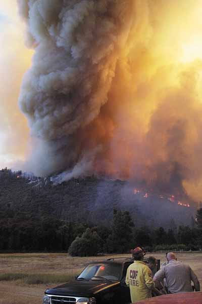
Not sure who to credit for this pic. It wasn’t mine. File says August 2004 but that may be when I first filed it. It is of the French Fire near Redding, CA. It was a CalFire incident. They probably have info if someone wants to research it.
I looked all over for that photo the day the Carr fire Broke. The gentleman in the CDF shirt is known to those I’m the North state as JB, or brother John!
It appears the video from Kern county shows plume spinning in opposite direction. Doubt they could turn different directions, I’d imagine the video is flipped during upload.
Um!? I know it’s real…but …was that video real!?
Thank you @TheBrushSlasher. I think those were 60’ spruce trees( intact) flying thru the air WITHIN proximity to the ASM.
Australia might be another place to look for fire whirl footage. With the fires they get, their is bound to be some footage out there somewhere. Be interesting to see and compare.
There are several videos out there with large rotating columns, not super rare but don’t happen often in front of ground resources. As mentioned Aviation get a front seat to them more then those in the dirt. Not talked about very much in fire behavior courses as there isn’t a whole lot of research on the large bad boys that I’ve seen. Let alone build in course work truly diving in to them (because of limited occurrence??) I heard conversation that some believe they come to life from rapid rates of spread creating horizontal vorticies then catching a disturbance to spin it vertical. Wish we had video from birth of these things. Remember the firewhirl with the CDF engine getting burned over on hwy 395 back in the 90s. Its on youtube. Not quite a large rotating column but very impressive. Battling winds of the Sierra Crest I believe???
I’ve been looking for that video but UTL. As far as causation, it’s s local “wind” caused by the escarpment. Air pours from the Sierra’s to the geat basin. Just so happens this area along 395 is the “Rim” of the glass ,as the air pours over the edge toward the low around the 4 corners, or micro- locally, as the dry lake beds and adjacent deserts warm up, cool air pours off of the Sierra’s to replace it.
Yup, exactly. We see this all the way down to through the so cal counties as cool air is getting pulled off all the mountain ranges to the deserts. I’ll find the video for you when I get a chance
Havent been able to find the longer version for a few years. I remember it showing the fire whirl before it came off the hillside down to the hwy. Lots of good indicators, like the Indians fire, etc…