When are you teaching that?
I asked Zeke in a PM if he had the Harlow fire of 1961 all by itself. It didn’t dawn on me that when he said he “simplified the polygons” that the fires were actually still in separate files. I just thought it was one file so I didn’t explore and keep clicking and digging and clicking.
This is an amazing piece of work that I don’t think most, like me, understand the implications of if you dig into it!! This is a complete walk back through my 30 year career being able to look at all the fires I have been on.
It is amazing! This is like the ultimate historical Christmas present!
Zeke, great job!! But do you realize how long its going to take me to go through all the names? I have to admit, each time I find another one it puts a smile on my face and brings back memories (and a cringe or two).
Thanks, @IMT_Geek
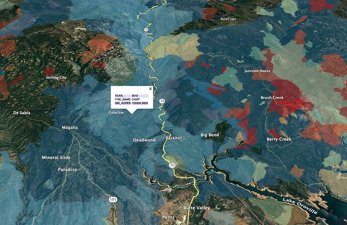
He is referring to the fire history KML layer I shared awhile back:
http://deercreekgis.com/files/California_Fire_History_1927-2019.kmz
If you open the file in Google Earth, you can copy and paste individual fires into your table of contents, or save the individual fires as their own KML/KMZ files. This can be handy for bringing them into Avenza or Cal Topo. The fire’s perimeters are simplified to be small enough to get them all into one file, so the geometry is not spot-on, can be off a few hundred feet.
Chief, you can always hit me up at HQ. I’m back there right now on light duty, doing my old job as a GISS.
I just created a new KML for the most up-to-date California Fire History layer (2021).
This is free for non-commercial use, with attribution (if you share maps made from it on social media, cartography projects, or in presentations, please credit Deer Creek Resources).
If you want to use this data on a commercial website or cartography project, please contact me for licensing.
http://deercreekgis.com/files/Ca_Fire_History_Thru_2021_DCR.kmz
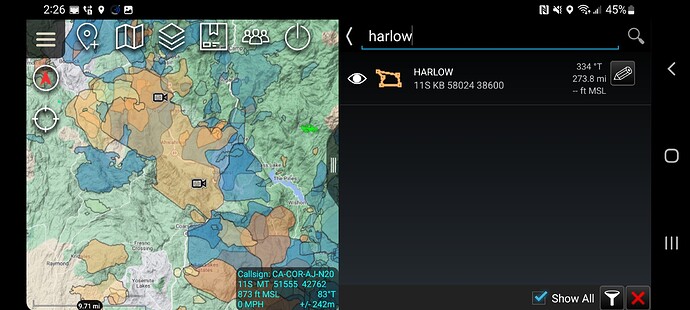
Thanks Zeke! Your web address a KML network link worked perfectly in ATAK and I easily searched for the Harlow incident.
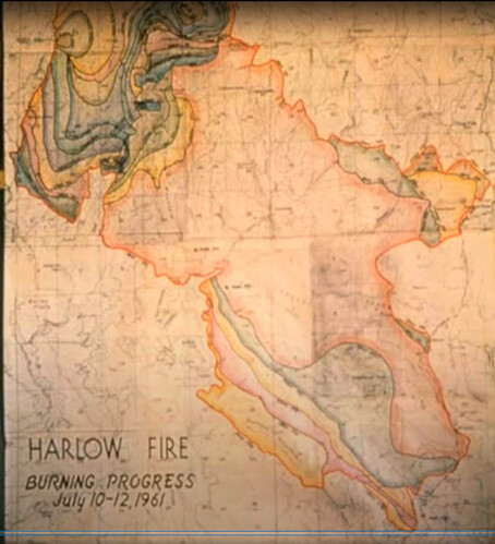
Yes, right there. I was hoping to get a progression map but one may not have been done. There is an image on a movie about it, but it was all hand drawn cartography (high tech for the '60’s!) and probably doesn’t exist outside of that map.
Once I figured out the treasure trove of incidents I kinda got distracted. I’ve been finding and copying the fire files I was on literally from A (Angora) to Z (Zaca).
I’ve thought about making a map of all the fires we have helped map between NorthTree Fire and Deer Creek GIS. At the end of 2020 we were up to over 200 Type I or II GIS assignments since 1999, in 10 states. A lot of mouse clicks and headaches have gone into all of those fire perimeters!
Here is a way back machine view of what your grandparents did, before GIS, computers, and everything else besides a good box of colored #2’s. This is the fire progression map of the July 10 through 12th 1961, Harlow Fire in Mariposa-Oakhurst area. We know the fire will someday repeat itself, so we are trying to get traction with the Firewise program in our neighborhood.
That’s some art, there.
Here is a prescribed fire history layer made from CAL FIRE/FRAP’s interagency fire history layer, updated thru 2021. http://deercreekgis.com/files/Ca_Prescribed_Fire_History_Thru_2021_DCR.kmz
This dataset is known to be incomplete, but the best data I can find online. We simplified it to make it web-ready.
If you need more detailed datasets for planning purposes, you can download the original data from FRAP.
Operational Update
The gdb isnt posted on the McKinney, they have their products but not the daily gdb. I see all other fed/state posting it. Not sure if the ftp is screwed up or what. I plan to make mbtile maps of just the event polygon,line,point, labels but need that gdb of course to make it happen. Guess will.wait until.morning before i make some inquiries. Anyone know of any issues with posting the gdb zip?
Other people definitely have bigger problems than me right now, but Mills Fire is an example of where CAL FIRE Intel Shop restricting access to their realtime intel is resulting in public being less informed. I was able to download open-access FIRIS and broadcast it via Youtube livestream to 2,000 people in 2 hrs, but FIRIS plane left once Courtney/CAL FIRE plane arrived and now there is no public access to the CAL FIRE/Courtney intel. I have many followers who are first responders, volunteers, horse rescue people, etc without access to the NIFC EGP or other portals where the CAL FIRE IR gets shared. It is hard to see how it is in the interest of anyone to restrict access to this data, which mainly has value in the first hour or two it exists.
Following up on this topic:
How are current fireline folks getting access to and using the realtime IR products from FIRIS, Firewatch, and Courtney? Is there a CAL FIRE COP/App, or are people accessing it via the NIFC EGP website? What levels of firefighter/leadership have access to the data? Is it easy for State/LG FFs to get access to the NIFC EGP?
Do local and State LE partners have access to CAL FIRE intel products in the field? Other cooperators?
Removed comment
I will start with a COP rant.
The OES-SCOUT program for CA has been available for years but poorly advertised IMHO. It had a lot of great features as an all risk tool but the code got a bit stale, the company that originally deployed it after it came from MIT struggled with it. That code is still alive under DHS S&T as NICS-NATO. I seriously see this as a missed opportunity from FEMA to have a national all-risk COP for everyone to use but that is water under the bridge. The OES SCOUT program is now going to use Intterra SA just like the Feds and many other local government agencies.
All cooperators with the Feds can get access to EGP/Intterra SA. It is very easy and has access to FIRIS and Firewatch. I have logged into Intterra with a local government account and I do see the Courtney data. Since my NIFC EGP/Intterra password is locked up I don’t know if the Courtney data is across all environments.
Cal-Fire is using Technosylva’s Tactical Analyst as their COP and is populating many data sources. Since Courtney is under contract I am sure their data is coming in. I believe contract counties have access to TA.
I will end the COP thing with we will never get everyone on the same COP. Even with my dream of the NICS program being a national COP all these programs are for the willing. Nothing is forcing participation.
Now I will start on my data rant. These IR products in my opinion should be openly shared. We share the location of a hurricane in real time, why not a fire? Some say the data needs context to be explained to the public. Some say the data needs to be vetted before being shared. I have heard all the excuses and none of them hold water. People and the media will make their own assumptions with public data like VIIRS and MODIS so why not get them accurate data? The FIRIS program has a two year plus record of sharing the IR data publicly. I am not aware of any issues with the perimeters being shared so you have to ask why dont all agencies share them publicly?
So let everyone use the COP they want as we all have our preferences and then lets all share key elements of data between our COPs.
Let the IR data from the feds and cal-fire be open to everyone.
Feds-Intterra EGP (can be accessed by mobile browser)
OES-Intterra All LG personnel can get accounts. Fed and state personnel can as well. (Mobile browser access as well)
CAL FIRE- TA (Mobile app), WFA from Technisylva. They can get accounts from other COPS as well.
It’s very accessible to all fire personnel. Becoming more mobile friendly as the COPs evolve.
Amen. Share the data.
For a mobile experience on a phone for tactical applications, the Android Team Awareness Kit is above anything else I have used. I have tested them all. It will ingest all the data, has sat com capability, great offline capability, etc etc. I understand why folks use other products but if you want connectivity anywhere TAK is really where its at.


