Try this website.
https://bigislandnow.com/
I’ve seen videos of the banyan tree. I wouldn’t give up on that old girl. As you all know, many trees can take quite a relatively hard short hit and come back. Thinking positive thoughts.
Hey everybody, this isn’t Cali or any other continent destination. It’s a relatively small island destination.There is literally no where left for you to vacation at for the time being - short/med term. Be grateful you’re not in the middle of it!
Peace!
Thanks bootstraps for the woods of advice.
I’m trying to get lodging for my son and his girlfriend, who live there. Her boss’s business is gone and their house.
Wish you the world during your recovery and rebuilding!!
Death toll now up to 36:
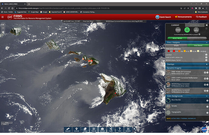
This morning’s NASA/LANCE/FIRMS image. Different from yesterdays, MODIS Aqua instead of MODIS Terra and symbolized as Time-Based. My question is: Is there NIROPS capability in Hawaii?
No real heat showing on the GOES satellite overnight.
https://rammb-slider.cira.colostate.edu/?sat=goes-18&sec=full_disk&x=6972.25&y=6462.1875&z=7&angle=0&im=24&ts=3&st=0&et=0&speed=130&motion=loop&maps[borders]=white&p[0]=fire_temperature&opacity[0]=1&pause=20230810140021&slider=-1&hide_controls=0&mouse_draw=0&follow_feature=0&follow_hide=0&s=rammb-slider&draw_color=FFD700&draw_width=6
Any word of Cal Fire headed to Hawaii? You may laugh but it wouldn’t surprise me
FEMA Region 9 IMT 2 is assigned. Arrives today about 1800.
Maxar photos, before and after
I heard a rumor that some OES engines may be sent . Not sure if it will actually happen or not .
Having taught classes over there it is more likely that they would ferry engines over from the other islands
I’m speculating that this is the FEMA IMAT, not IMT out of Oakland. Whoever picks up the management assistance for this has a heavy lift. Good luck to all!
A primer for FEMA IMAT orientation:
Major disaster declared.
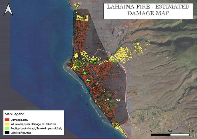
Spent a couple hours interpreting the before after pictures and helo footage from Lahaina. Here’s my thorough and educated guess on where the extent of damages were using Maui County building footprints from 2020. The green buildings among the red were seen via the Maxar-provided before and after images. The eastern, southern, and northern ends of the fire did not have that imagery so the interpretation was from other photos and helicopter footage from the scene.
Looks like about 2,000+ affected structures, eh?
That’s exactly right, by count I had 2100 red building footprints. That whole north end of town didn’t have satellite images but the video showed it just as badly hit. There will be some random structures in tact in there. There may be more damage from the ‘Unknown’ group I’ve marked as well. Anything in the middle of the action left standing will be heavily smoke damaged as it is.


