
2 USAF Hurricane Hunter flights scheduled for the storm tomorrow:
6 Likes
East Pacific hurricanes are not like their Atlantic cousins… They fall apart much faster and do not have the same energy. Typhoons( west Pacific ) hurricanes are a different story. Much of this has to do with not only with water temperature and depth of the water temperature but the atmosphere as well. The Gulf of Mexico has much warmer water and a different climate that is more conducive to large storm development. The waves that come off of Africa and are the genesis for hurricanes develop a lot of energy over the warm waters of the Caribbean and the Gulf. They then enter an atmosphere that has higher dew points and more humidity. We have deserts here… that dry air tears the storms apart.
You can watch dry slots of air during Atlantic hurricanes, high pressure in the right spot will tear the storms apart or “destructively” phase with the storms and cause them to fall apart.
While the SST off the coast of Baja are warm they are no where near what the Gulf of Mexico is.
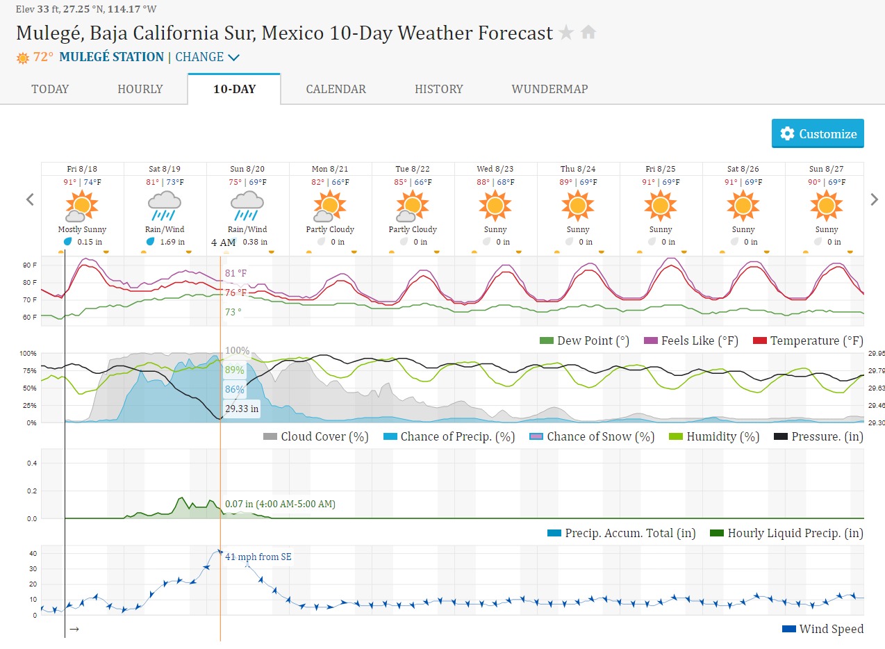
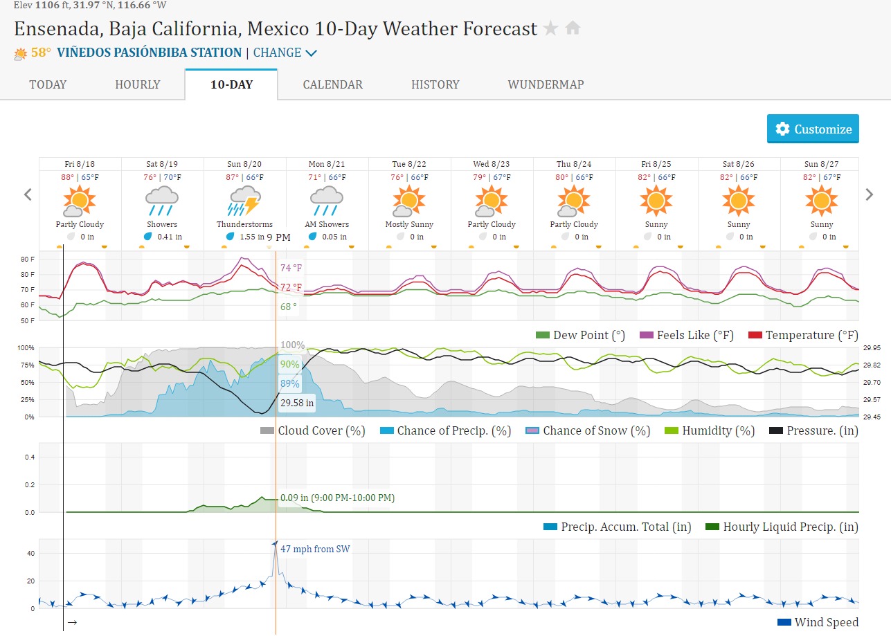
This will be impactful and will cause some damage from flooding but will not be anything like the storms that hit the SE.
7 Likes
“Strong” storms in the SE made me recall this. This was attention grabbing to my layperson eyes - to think that even more extreme storms occurred under a cooler climate than today! Yikes! #BeforeRecordKeeping
3 Likes
Thanks to Alex Tardy for this.

5 Likes
The storm is likely to put on another round of rapid intensification tonight, as the SHIPS-RI index is pretty high.

Hilary is currently going through an eyewall replacement cycle, which could explain the pause in intensification. If the storm completes the EWRC in the next few hours, it will likely reach category 5 status at some point tomorrow.
8 Likes
I’m not sure Hurricane Doreen in 1977 impacted the fires you mentioned.
Marble Cone started 8/1/77 I believe. Pondosa and Scarface started 8/3/77 (I know, I was there) and I’m not sure about the Mt Diablo Fire you referenced, but I don’t think it lasted too long.
Those fires had made their significant runs and were in pretty good shape well before Hurricane Doreen even formed off Baja on 8/13/77.
Now there was a significant fire outbreak on the Klamath starting around 8/11/77 similar to this year. They may have been affected by the Hurricane, but I don’t know.
8 Likes
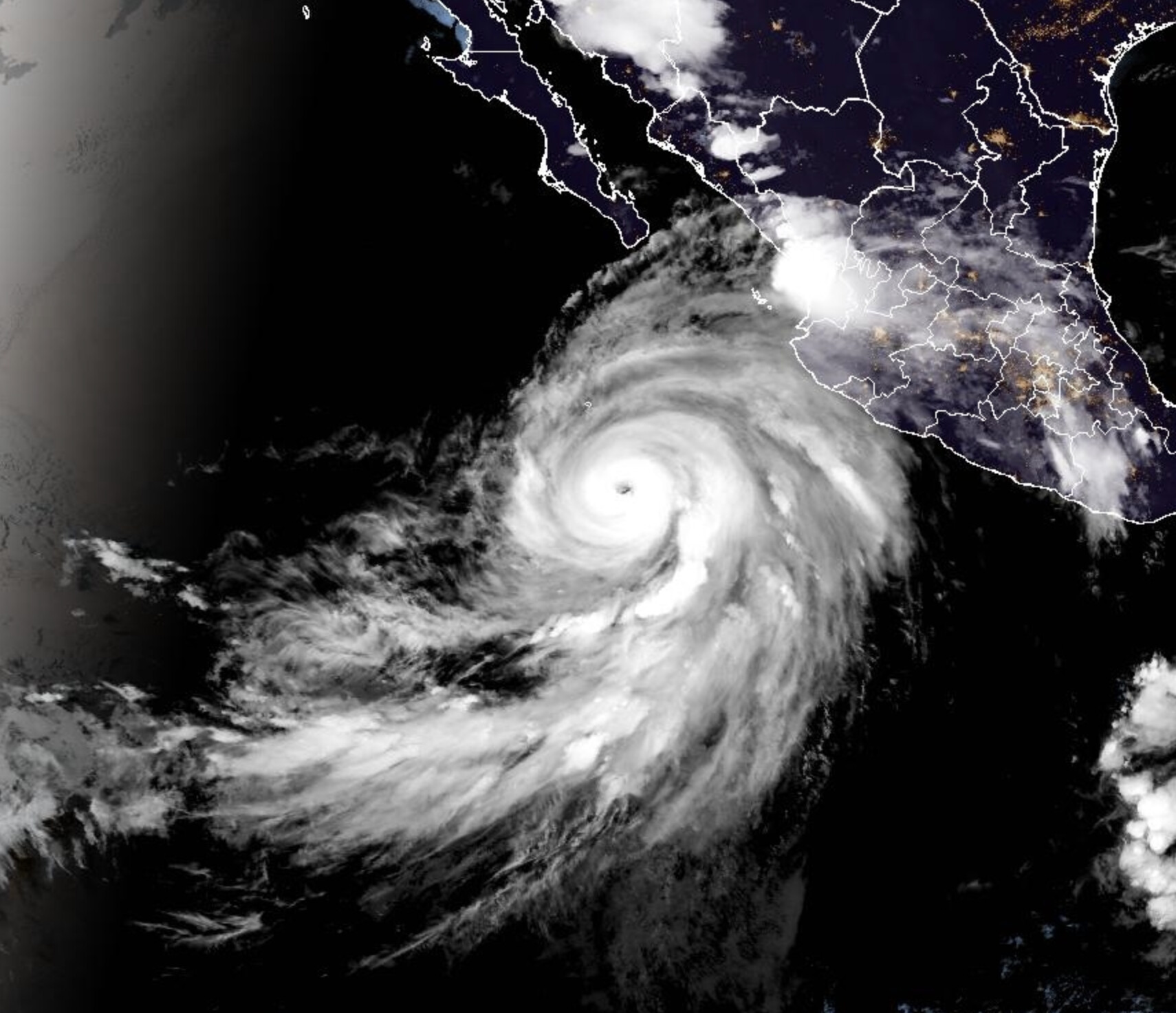
8PM PST update……Hilary has now strengthened again to 125 MPH and a central pressure of 953MB. Tomorrow morning will tell us so much more after the 1st hurricane hunters get involved
9 Likes
I’m hearing rumors of OES standing up multiple USAR RTF’s for potential flooding and damage to structures with debris flows possible.
9 Likes
ORC/OES Type 6 strike team will be inservice 0900, Sunday. And I’m sure that’s just the beginning.
5 Likes
Woohoo. Trudging through snow in the mountains around the Bay Area all winter wasn’t fun enough!
4 Likes
12:00 AM MDT Fri Aug 18
Location: 16.8°N 110.4°W
Moving: WNW at 14 mph
Min pressure: 942 mb
Max sustained: 140 mph
10 Likes
List of California hurricanes - Wikipedia
A very rare event, will be interesting to see, looks like a big rain event " I know Duh", significant run off…going to be a long miserable weekend… I appreciate the contributions to this thread…some very smart folks…I have learned a few things…thanks…
5 Likes
5 Likes
Hilarys wind has strengthened slightly early this morning. Up to 145 MPH
6:00 AM MDT Fri Aug 18
Location: 17.3°N 111.0°W
Moving: WNW at 13 mph
Min pressure: 942 mb
Max sustained: 145 mph
6 Likes
Man, baja is gonna get hit hard! Hillary is going to cause some massive damage.
4 Likes
Storm surge and waves will be rough on the beach towns. Probably wanna stay off the rocks and jettys and stuff. This ain’t their first rodeo on the ocean side.
7 Likes
It’s all the rain landing in the mountains and coming down the arroyos. The transpenisular will get major damage.
4 Likes

Hilary continues to strengthen and now has a min pressure of 939 mb
9:00 AM MDT Fri Aug 18
Location: 17.9°N 111.4°W
Moving: NW at 10 mph
Min pressure: 939 mb
Max sustained: 145 mp
6 Likes