State ID: ID
3 letter designator: SCF
Fire name: MOOSE
Location: 21 miles N/W of Salmon, ID
Reported acres: 12,238
Rate of spread:
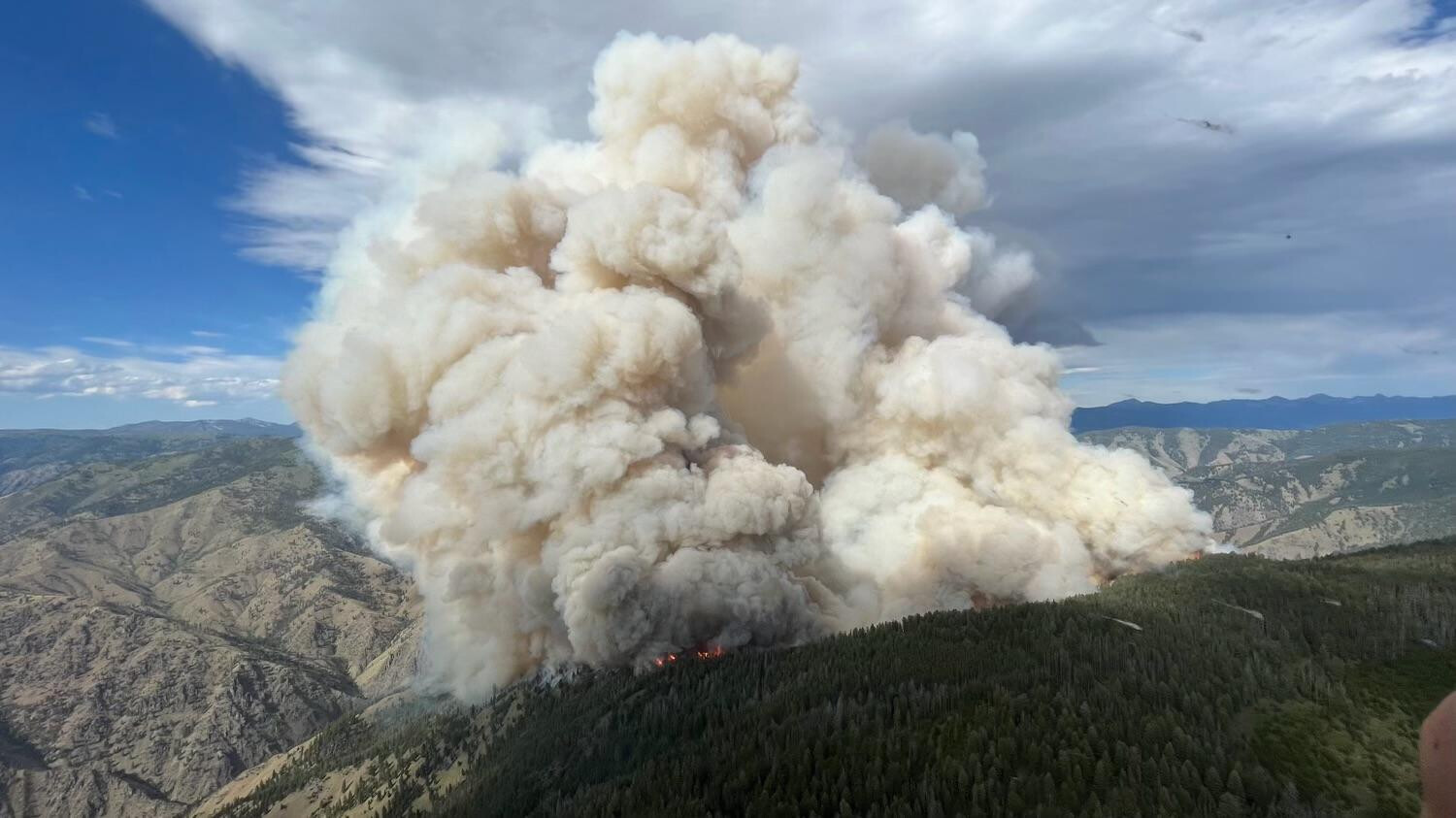
Report on Conditions: Extreme Fire behavior with uphill runs & long range spotting, Fire is burning on both sides of the Salmon River, Expected movement to the south east towards the town of Salmon and north east into the Hwy 93 corridor in the North Fork area.
Structure threat: Still evaluating
Resources: 190 personnel
Hazards:
Weather: Very dry conditions are expected today for the entire area with humidity values in the valley bottoms dropping into the 5 to 10 percent range. After relatively light winds early in the morning, breezy conditions will take over midday through the evening. Winds will be lighter than Monday, but sustained west winds around 10 to 15 mph can be expected with gusts around 20-25 mph in the afternoon. Humidity values will slightly improve Wednesday and Thursday, but similarly breezy conditions will remain.
Radio channels:
Scanner link:
Webcam link:
Agency Website: www.fs.usda.gov/scnf
A Type I Incident Management Team has been ordered and will in-brief with Forest Officials today. Yesterday, crews assessed values at risk in the vicinity of the fire and implemented point protection for those values as necessary. Aircraft was used as weather permitted, the high winds limited the use of aircraft. There was a spot fire east of Highway 93 yesterday afternoon, crews were able to quickly contain the spot fire to an area approximately 50’ X 50’. Crews conducted a burnout late yesterday behind the North Fork Ranger Station to help slow fire growth to the east. Today, crews will continue assessing values at risk and implementing point protection as necessary with aircraft being used as weather permits.
Inciweb is reporting this morning the fire has increased to 16, 581 acres with 0% containment. Great Basin Incident Management Team Two is now managing the fire. Yesterday extreme fire behavior was observed, with uphill runs, short crown runs, and long range spotting with similar fire behavior expected today. The weather for today is expected to have similar conditions like yesterday with very dry conditions for the entire area, humidity values in the valley bottoms dropping into the 9 to 13% range. Winds will be relatively light in the morning, breezy conditions will take over midday through the evening with winds 10-15 mph with gusts to 20-25 mph.
Total Fire resources assigned:
Personnel- 376
Crews- 13
Engines- 24
Helicopters- (5) Type 1, (1)Type 2, (2) Type 3
As of Thursday July 21, 2022, the fire is now at 20,648 acres with 517 personnel committed. Significant Events: Active fire behavior with uphill runs, group torching and spotting. The fire became active in the afternoon on the west, south and east flanks with smoke clearing and westerly flowing winds. High instability allowed for column development and continued fire growth.
Weather:
Thursday will continue the hot and dry weather with the airmass a bit more unstable and ridgetop winds a bit stronger. Slope and valley winds will dominate the lower elevations and generally be less than 12 mph. Highs will be in the 90s on the river bottoms and midslopes and upper 80s at ridgetops. A Fire Weather Watch has been issued for critical conditions on Friday.
Moose Fire map July 21 2022.pdf (3.2 MB)
Very sad news indeed, I hope the crew is safe and their injuries were not serious…definitely have my thoughts and prayers for the family and the crew.
NBC news is reporting the two pilots of the Chinook Helicopter did not survive the crash, this saddens me to hear this news, god speed and prayers to you and your families, rest in peace brothers and thank you for your service.
The Moose Fire is now 23,620 acres with 0% containment, they have 690 personnel assigned to the incident, 19 hand crews and 39 engines.
WEATHER: A Red Flag Warning has been issued for hot, dry, windy conditions
28,839 acres, 0% contained, cause undetermined. About 5 miles southwest of North Fork, ID. Grass, brush and timber fuel types.
There will be a VIRTUAL PUBLIC MEETING TONIGHT AT 5:00 P.M. on the Salmon-Challis National Forest Facebook page: Redirecting...
Yesterday’s Red Flag weather conditions increased fire activity along the top of Napoleon Ridge. Firefighters patrolled the Highway 93 corridor to seek and extinguish spot fires. North of the Salmon River, firefighters succeeded in holding line built during the last several days. Last night, the fire continued burning actively, spreading west as far as Kayak Camp and reaching the west bank of the Salmon River in the North Fork area.
Today firefighters will continue holding and improving line around the north end of the fire. Structure protection will continue along Salmon River Road and Highway 93. On the southeast side of the fire, crews and heavy equipment will work on building an indirect line along Diamond Creek Road from the Highway 93 corridor up into Five Corners.
Moose Fire Daily Update
- 32,330 acres, 0% contained, cause undetermined. West of North Fork, ID. Grass, timber, and brush.
Yesterday, firefighters continued holding and improving line around the north end of the fire. Structure protection continued along Salmon River Road and Highway 93. On the southeast side of the fire, crews and heavy equipment worked on scouting and building an indirect line along Diamond Creek Road from the Highway 93 corridor up into Five Corners.
Today fire behavior is expected to increase the likelihood of spread on the western side of the fire perimeter, south of the Salmon River towards Spring Creek. On the eastern flank, fire is expected to spread east towards North Fork with potential spotting to the north side of the Salmon River. Fire growth is also anticipated to the south towards the Moose Creek area. Firefighters will continue structure protection along Salmon River Road and Highway 93 to protect values at risk using a point protection strategy.
WEATHER: Yesterday, an inversion held smoke in through the early afternoon before partially lifting with northwest ridgetop winds up to 15 mph. The smoke kept temperatures cooler with humidity higher than previous days, expect similar conditions for today with slightly higher winds and stronger instability with a weak trough moving over the area.
EVACUATIONS: The Lemhi County Sheriff has placed Zone 2 (residents on the west side of Highway 93 from Tower Creek to North Fork) in a “GO” evacuation status. The latest updates from the Lemhi County Sheriff’s Office can be found at https://www.lemhicountyidaho.org/site-home/urgent-alerts/latest-updates-moose-creek-fire. The fire remains very activity and all residents in proximity of the fire should follow the Ready!Set!Go! guidance.
TOTAL FIRE RESOURCES ASSIGNED : 722 personnel, 19 hand crews, 36 engines; helicopters: four type 1, two type 2, two type 3
When California Type 1 Team 5 was there for the Mustang Fire we put together a very comprehensive structure protection plan. Hopefully it is still there and being used. It would save a lot of ground pounding and time.
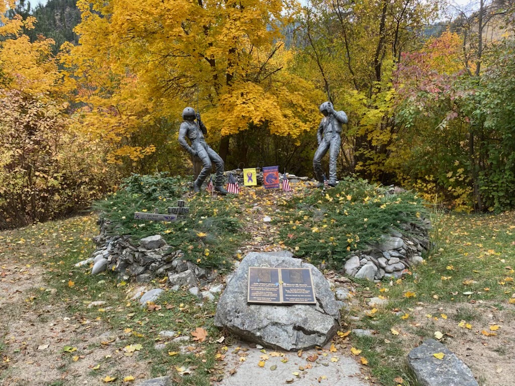
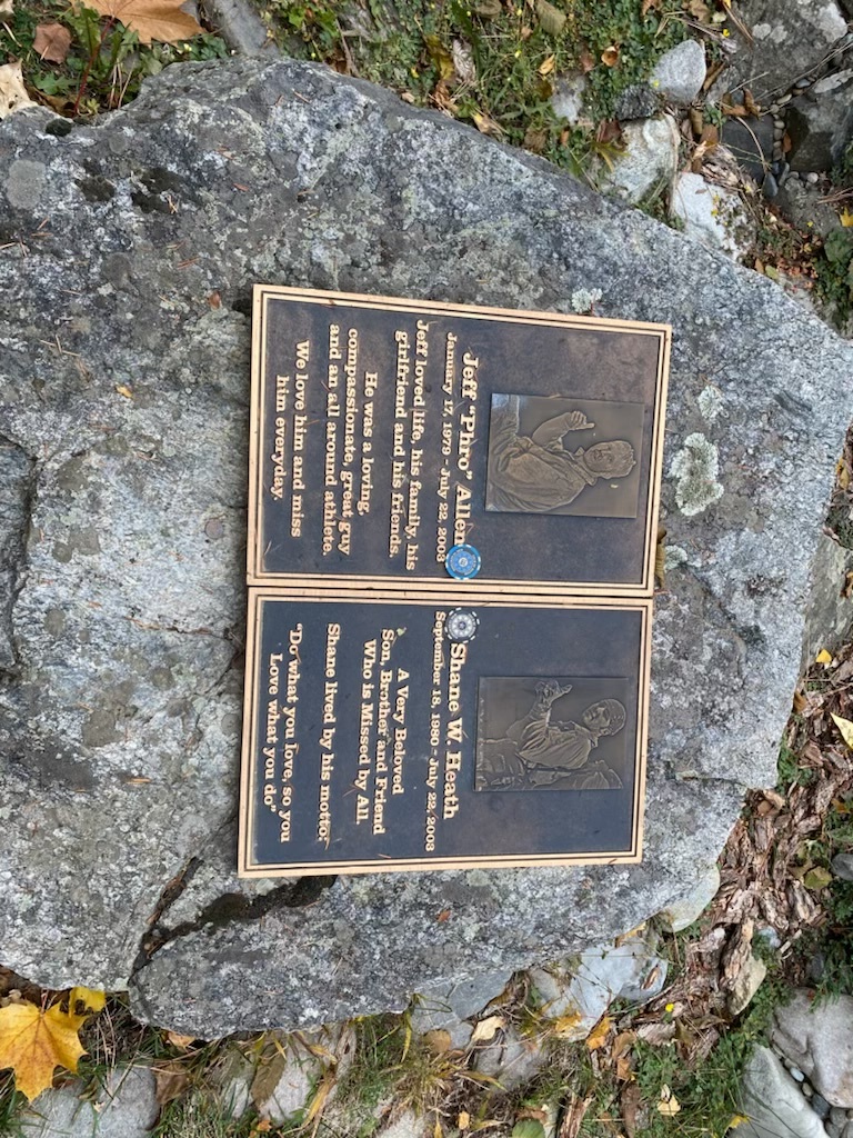
Blue-Green, hopefully that plan is being used to facilitate structure defense, I love this area as I have vacationed, and hunted extensively the North Fork of the Salmon for many years. I know the area has, quite the fire history in the past 25 years. The steep terrain of the Salmon River Breaks can be very challenging, to say the least. I know in the early stages of the fire, the USFS fired out around the Indianola FS station, which I was glad to hear, because each time I visit the Kramer Fire Memorial at the Indianola Fire station, I’m reminded how precious each and every life is of firefighters who have lost their lives, doing what they love.