hey guys,
The Weather Service called it particularly dangerous along the U.S. 395 corridor from Susanville to Mammoth Lakes. Downslope winds could reach 60 mph in those areas while humidity will drop to less than 10 percent. Some winds will continue into Monday afternoon.
Most areas will see southwest winds of up to 30 mph with gusts to 45 mph, the Weather Service said.
These conditions will result in extremely rapid fire growth for any new fires along the 395 corridor,” the Weather Service said. “If you are in a wind prone location, have an evacuation plan ready in case a new fire threatens your location.
The Weather Service also asks people to avoid outdoor activity that can spark fires.
thanks and regards. shareit vidmate apk
There always seems to be one last “ripper” with the frontal winds just before the rain…
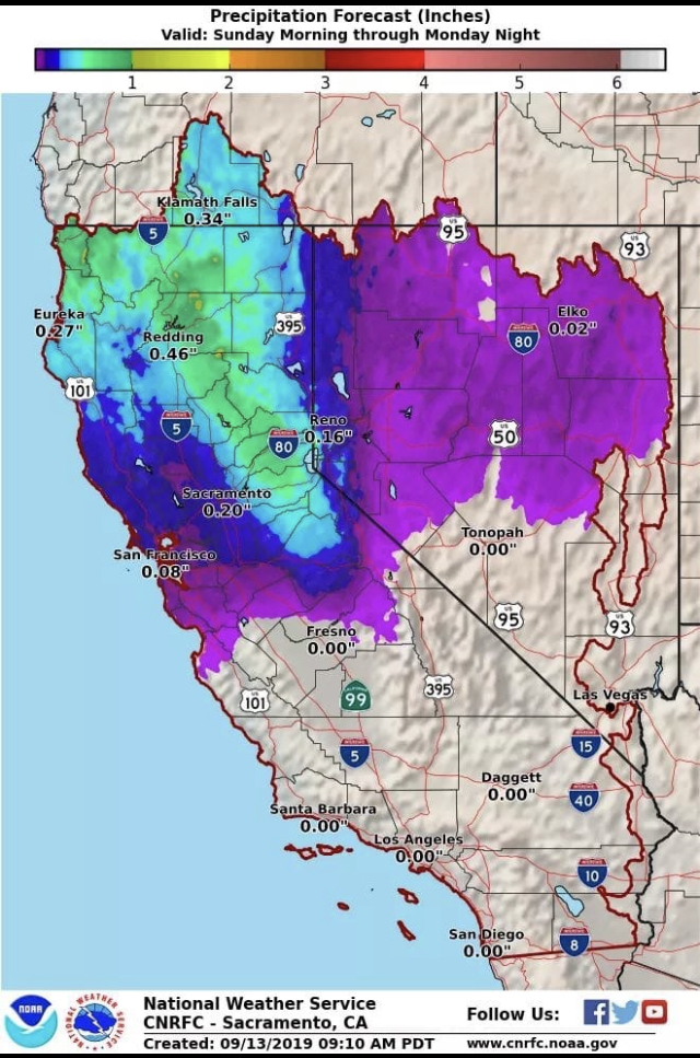
.51" since 0200
1800’ elevation, east of Redding.
Dumped here in Grass Valley most of the morning, now letting up but still coming somewhat, el. 2600
What areas did not get significant rain?
BTU/LNF/PNF have a few smokes on the fire cams it looks like. Big Bend area, midslope up Grizzly Dome up 70, and north of Flea Mtn. NIFC lightning map last 24hrs shows strikes right where the smokes are. (technology is awesome)
Fire Weather Watch issued for Sac Valley and foothills for North winds Monday to Tuesday night.
Fire weather watch for the north bay and east bay hills starting Monday https://www.weather.gov/mtr/
Upgraded to RFW’s now
The Fire Weather Watch has been upgraded to a Red Flag Warning for the North Bay Mountains, East Bay Hills, and Diablo Range from 9 PM Mon to 5 AM Weds. Gusty offshore winds and dry humidities in the teens will create critical fire weather conditions
A post was merged into an existing topic: 2019 staffing patterns
This is a cool site for looking at large-scale winds.
That site is also good for particulate matter, and even the Auroras
Looks like the front will be bringing some good amounts of snow to higher elevations
Interesting weather comming this week. Back up to 90 degrees in the Redding area.
With those warm temps we can go outside and listen to the new crop of grass grow.
There is some pre-positioning planned for Friday-Sunday around NOPS. Sounds like crews and engines- not sure if OES is doing anything but CAL FIRE is.
If models are correct could be a more impactful event next week that could be a strong NE wind event for much of the state… still a ways out.
Red Flag Warnings for North Bay Hills Saturday Night.
https://forecast.weather.gov/product.php?site=mtr&issuedby=MTR&product=RFW