A post was merged into an existing topic: Prescribed Fire Theory/discussion
Looking at the extended forecast, North wind event upcoming this week. As well as the following.
1 Like
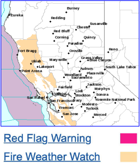
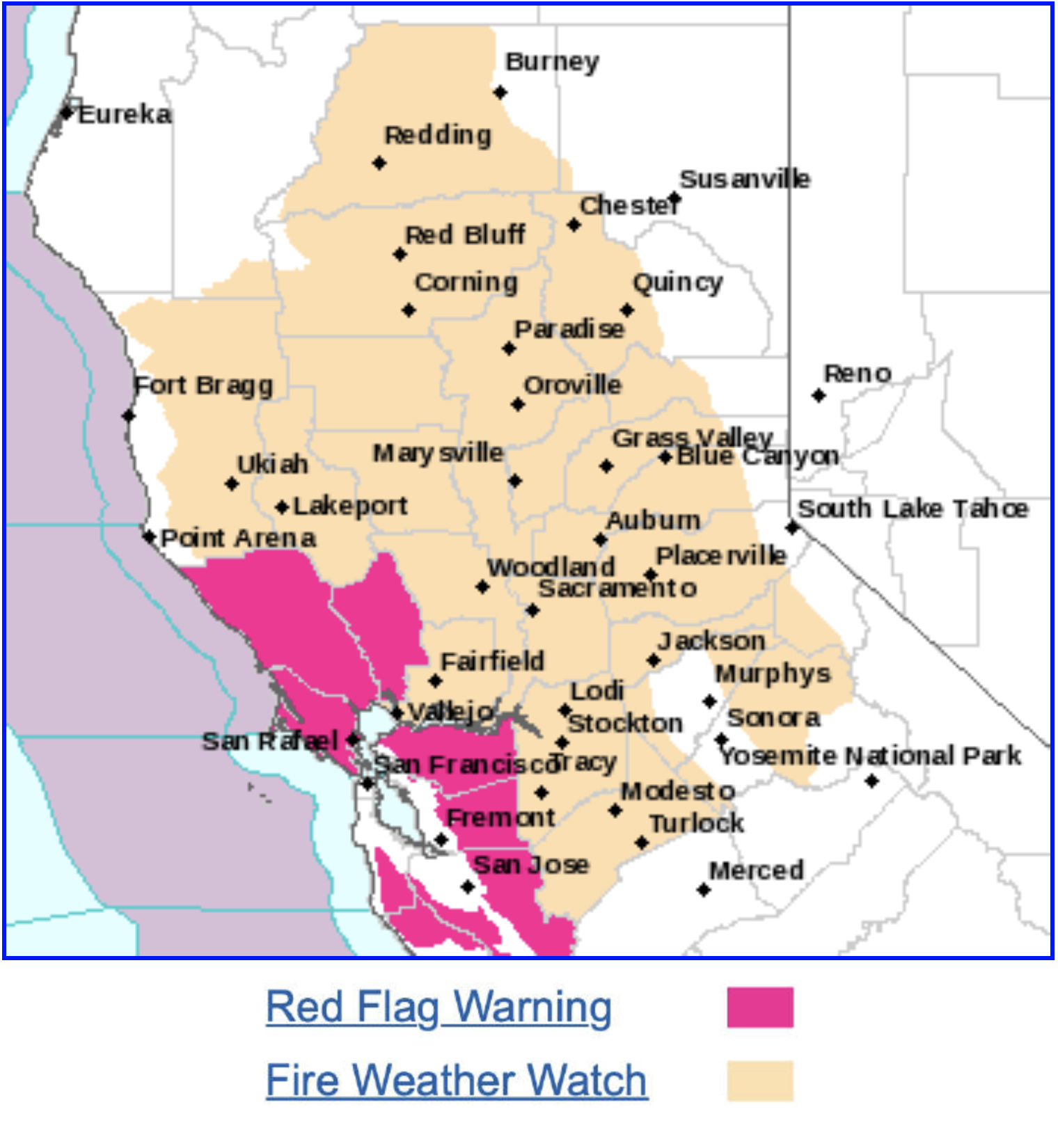
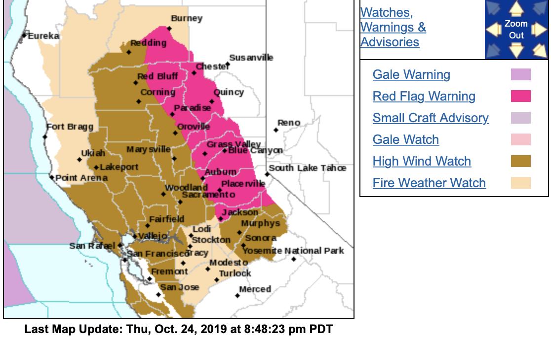
NWS - San Francisco CA - 127 PM Mon Oct 21
…Fire Weather Watch for North Bay Mountains, East Bay Hills and
Santa Cruz Mountains Wednesday and Thursday…
-
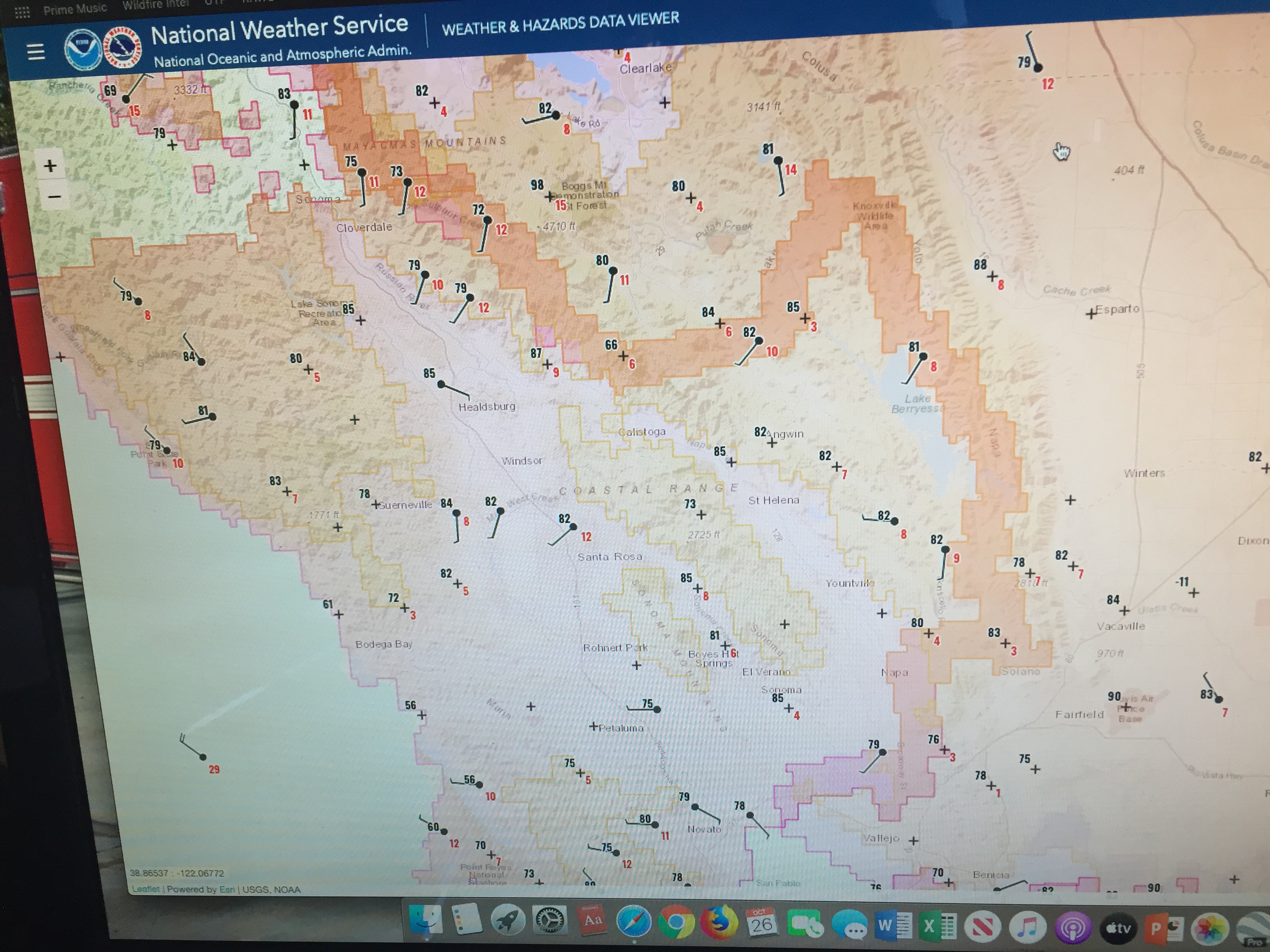
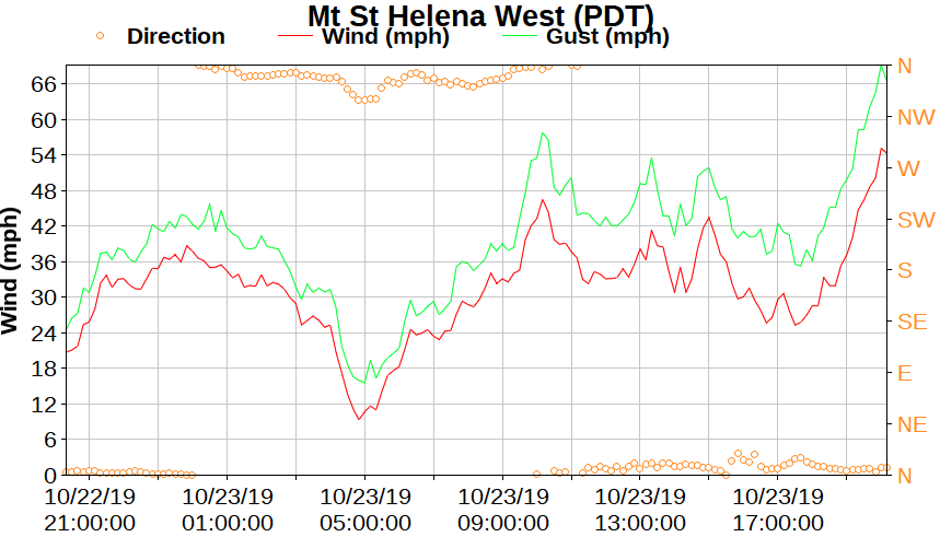
WIND…North to northeast winds 15 to 25 mph with gusts 30 to 40
mph. Locally higher gusts to 60 mph over the highest peaks. -
HUMIDITY…Overnight humidity recovery of 25 to 35 percent.
Widespread minimum daytime humidity values Thursday in the upper
single digits to teens. -
HIGHEST THREAT…Higher terrain, particularly the peaks and
ridges in Napa and Sonoma County.
NWS - SF: 9:27 AM Tue Oct 22
Red Flag - Wednesday afternoon into Thursday
- North Bay
- East Bay Hills/Valleys
- Santa Cruz Mountains
.Warm and dry weather will develop by midday Wednesday. Strong
north to northeast winds will then develop over the North Bay and
spread southward over the East Bay and Santa Cruz Mountains
Wednesday Night into Thursday.
Another even stronger wind event is forecast Saturday Night into
Sunday across the Bay Area that may bring another round of fire
weather headlines.
1 Like
In the heart of the wind event now. But if you all have time to look for the projected event Sat and Sun. All I can say is holy crap NorCal.
3 Likes
No weather data available from Carpenter Ridge, Jarbo Gap, or Cohasset RAWS stations this morning. Guessing due to no power? Calm in Chico right now.
I thought all the RAWS were solar/battery powered, if they were Fed sites?
1 Like
There is a national issues with WIMS as well.
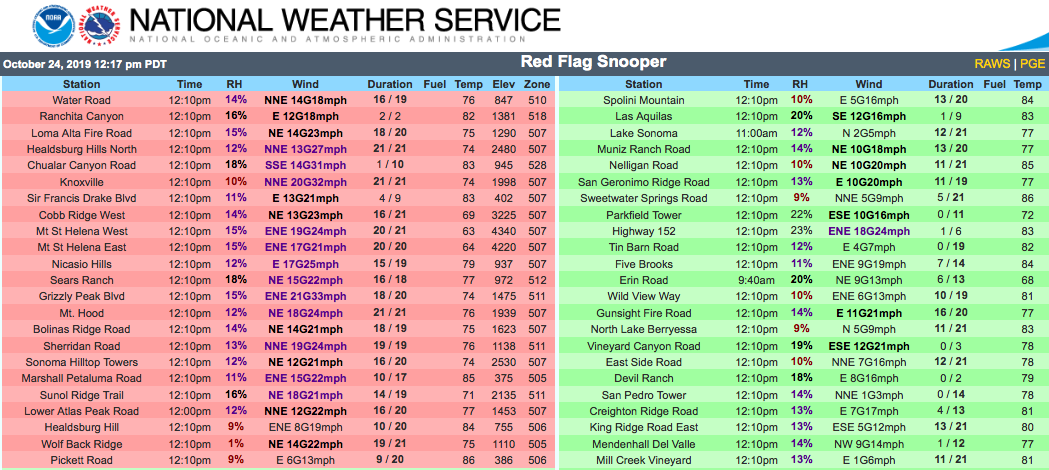
Do you have a link for the snooper?
1 Like
Thank you!
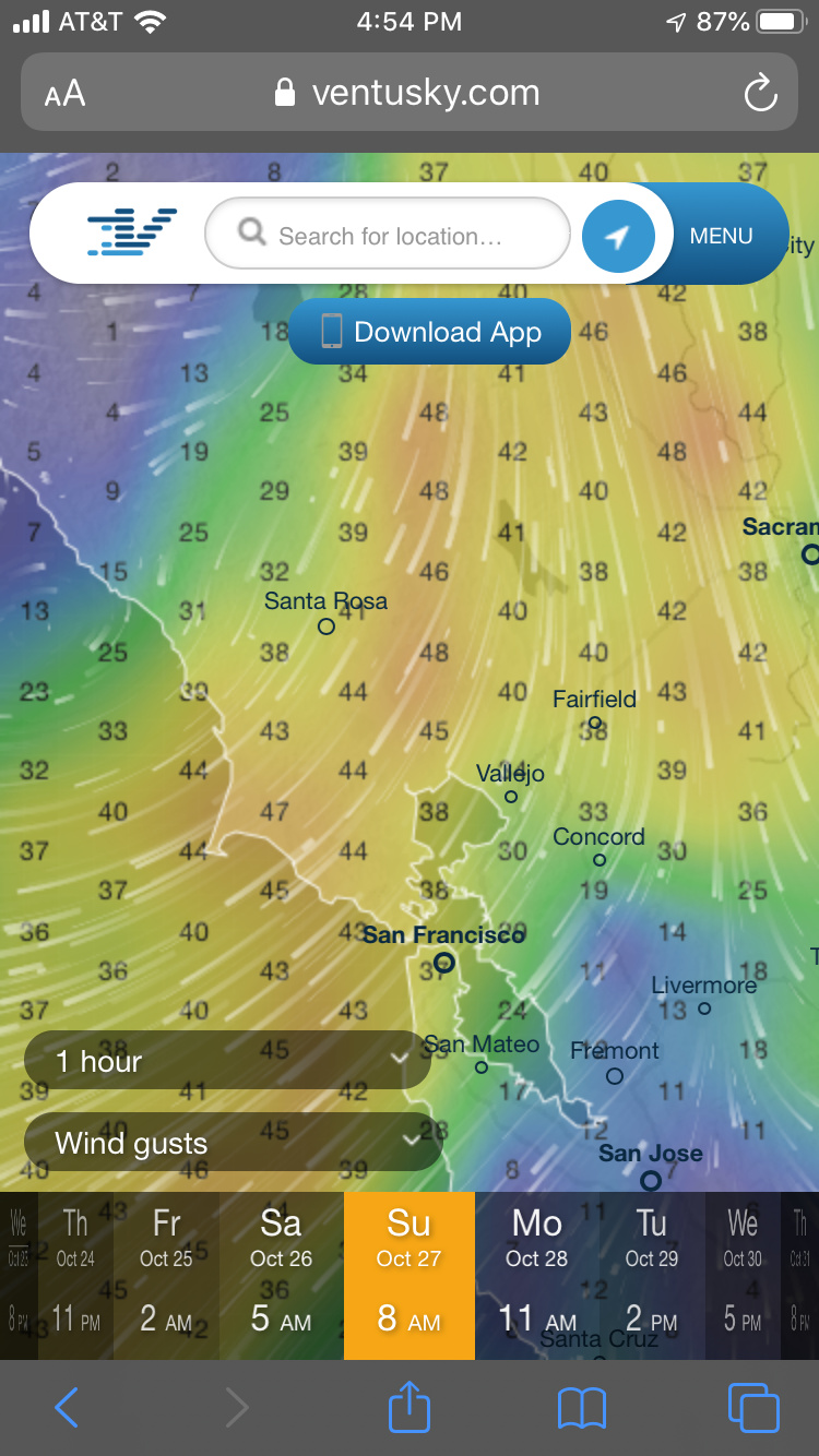
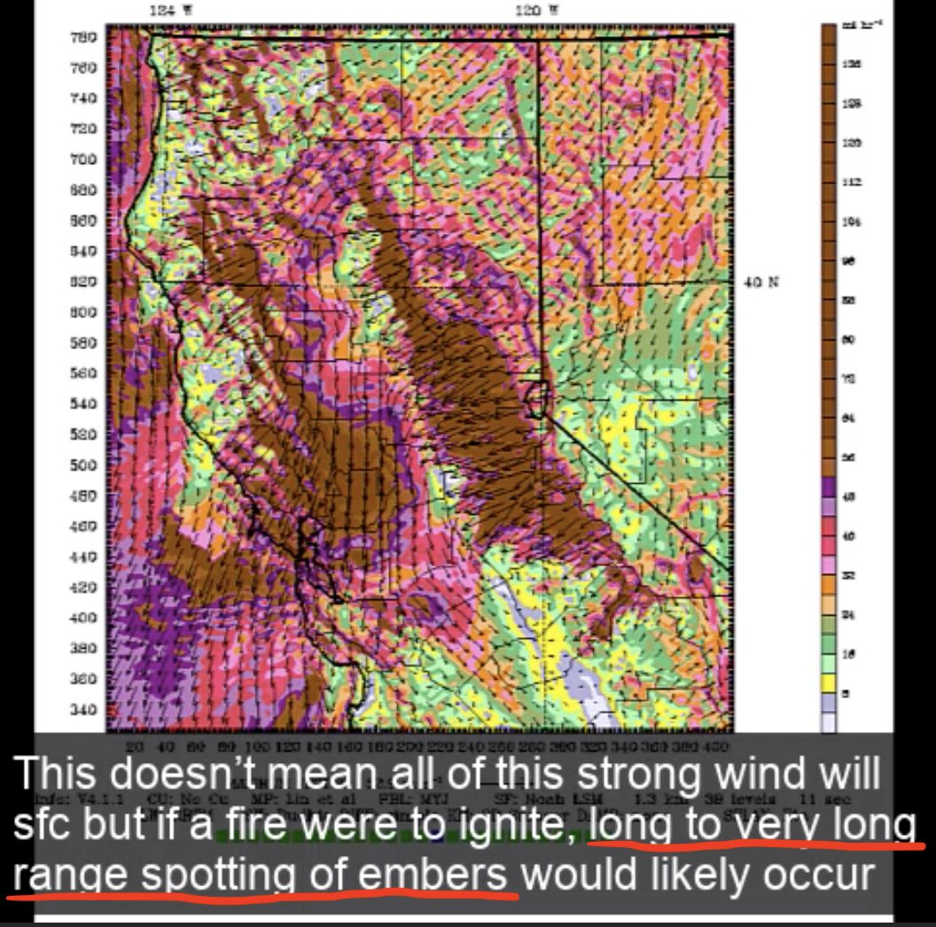
Now that todays offshore wind event is winding down, all operational focus has shifted towards this weekends offshore
wind event. Confidence is high that the strongest offshore wind
event yet this season will take aim at a broad swath of Northern
California late Saturday into Sunday. Internal confidence **
** statistics indicate offshore winds on the order of 4.3-5.2 **
** standard deviations above the norm (3.5+ usually is record **
** territory) will occur late Saturday into Sunday. This aligns with
forecast model data which shows the development of 60-70kt low to
mid level offshore flow during the same time frame. 70kt roughly
translates to 80mph, which is currently the top of end of forecast
gust range overnight Saturday into Sunday across the highest
peaks. In addition, these winds are anticipated to cover a broader
area across most of the San Francisco Bay area and Santa Cruz
mountains, with a higher likelihood of seeing these winds make it
to the lower elevations. Winds are forecast to taper down in
intensity with elevation, however, downsloping/mixing down of
winds could bring rather gusty conditions to areas downwind of the
hills/peaks particularly into Sunday. This downslope/mixdown phenomena
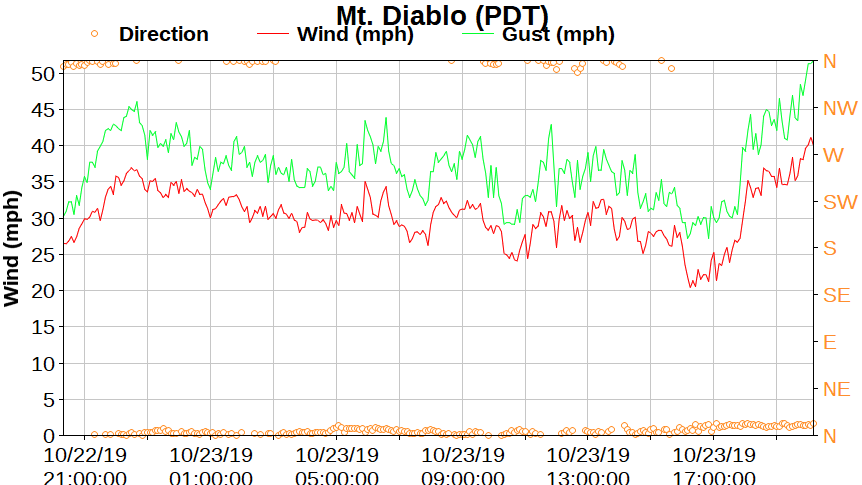
was particularly evident today, with gusty winds along the lower
slopes of the East Bay hills, downwind of the Marin headlands, and
particularly near Half Moon Bay, which was gusting to 50mph
around 7am this morning. As a result, may see some wind damage
impacts from this weekends offshore winds across a broader area,
such as downed trees, localized power outages, debris in
roadways, difficulty driving high profile vehicles, etc.
6 Likes
The Fire Weather Watch has been upgraded to a Red Flag Warning for the N/E Bay (8 PM Sat-11 AM Mon), SF Peninsula Coast and Santa Cruz Mountains (3 AM Sun-11 AM Mon). Confidence is high for dangerously strong offshore winds and critically low RH. Some weather Folks are calling this a potentially Historic offshore wind event. Time will tell.
1 Like
From @NWSBayArea: “This will be a long-duration and potentially extreme/historic event across the #NorthBay.” Can’t stress enough that this event will bring strong northeasterly winds to lower elevation places that rarely see them. #CAwx #CAfire
3 Likes
North Ops webcast - very interesting discussion about today’s wind event.
Watch video with weather images here: https://gacc.nifc.gov/oncc/predictive/weather/brief_files/brief.mp4
4 Likes