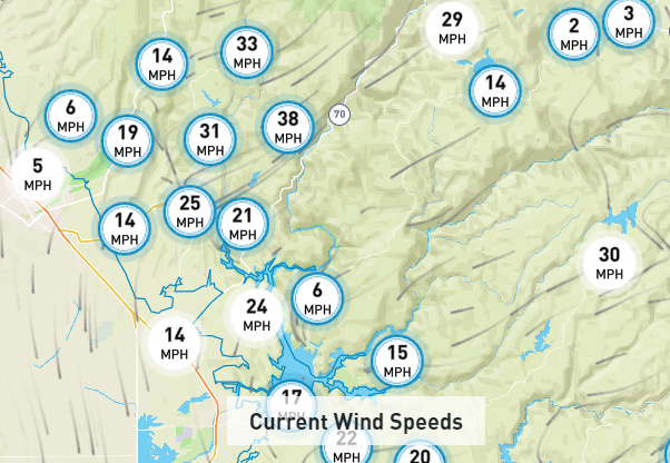
Wind is coming hard thru Jarbo Gap tonight. You can hear trees coming down around us in Paradise. Hundreds of thousands of burned trees out there in this mess. Wind is much harder tonight than last.

Wind is coming hard thru Jarbo Gap tonight. You can hear trees coming down around us in Paradise. Hundreds of thousands of burned trees out there in this mess. Wind is much harder tonight than last.
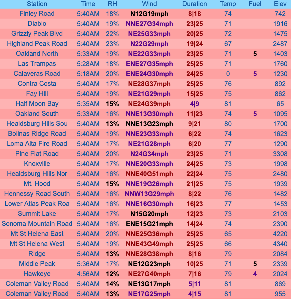
Wow, get your Speedo out and hit the beach in Half Moon Bay this morning!
Half Moon Bay Airport (KHAF) Severity:75
| TIME | RH | WIND | TEMP | FUEL |
|---|---|---|---|---|
| 05:15AM | 14% | NE26G43mph | 82 | |
| 04:55AM | 14% | NE21G41mph | 82 | |
| 03:55AM | 14% | NE25G39mph | 82 | |
| 02:55AM | 16% | NE16G28mph | 82 |
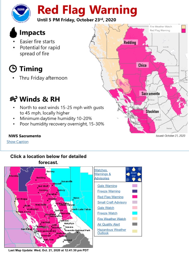
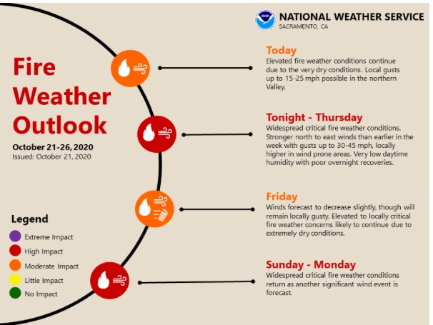
NWS SF Friday: First and foremost the Red Flag Warnings have been extended through this evening. A very dry airmass, and well above normal temperature are present. Persistent offshore flow continues as high pressure remains anchored over the Great Basin with lower pressure along the coast. Latest offshore gradient from SFO-WMC is -15mb to -16mb, which is a moderate to lower end strong offshore event. Resulting offshore winds look to have peaked earlier in the night with gusts of 60 to 70 mph in the North Bay Mts. Since then wind speeds have dropped ever so slightly - 45-60 mph. Winds are breezy to gusty in the East Bay Hills and Santa Cruz, but not the magnitude of the North Bay. Winds are struggling to hit the valley floors, but definitely making their way into the foothills (500-1000 ft) with gusts 20-30 mph. The downsloping flow has led to some mild temperatures overnight temperatures and no humidity recovery. Winds will weaken even more by mid-late morning, but the very dry airmass will remain.
29 Red Flag weather stations now and 95 RF and flirting.
Last Nights wind gusts in the Jarbo Gap/Concow were over 60 MPH with sustained winds over 30 . This kept up the rest the night . At sun up the gusts had dropped into the mid 40’s . The Red Flag Warning for high fire danger has now been extended through 6PM tonight for the valley, foothills, Northern Mountains, and a portion of the Sierra. Gusty north to northeast winds will continue to be the main driver in fire danger today, but the low humidity and well above average temperatures are also playing a big role. Sustained winds up to around 20mph are expected today, with gusts in the valley up to around 35mph. Gusts in the foothills and canyons are still over 50mph in some reporting sites this morning, and will be a big concern through at least early today. Humidity will dip to below 20 percent across most of our region, with some areas dropping into the single digits later today. High temperatures are projected to top out in the mid to high 90’s in the valley, in the 80’s to around 90’s degrees in the foothills, and in the 70’s to 80’s in most mountain areas this afternoon. The hot, dry, and windy conditions will result in high to critical fire danger today.Winds will finally diminish tonight as low pressure to our east moves further east, and high pressure in the Pacific builds into the West Coast.
Doug, Do you have the link for that one. Mine showed different listing
Thx
Offshore flow will continue but will weaken into tomorrow. This will result in continued above normal temperatures, localized breezy north to east winds, and low relative humidity values. Therefore, the National Weather Service still has Red Flag Warnings in effect for portions of Northern California through Saturday morning. Weak onshore flow is then expected to take over on Sunday, and temperatures are expected to trend down through the middle of the week. There is still a chance for breezy to gusty offshore winds again mid-week, but details on strength and timing are still quite uncertain, Winds Thru Jarbo Gap calmed by mid morning. A fair amount of storm damage to deal with in regards to down and broken trees in the area . A lot of flying firewood last night
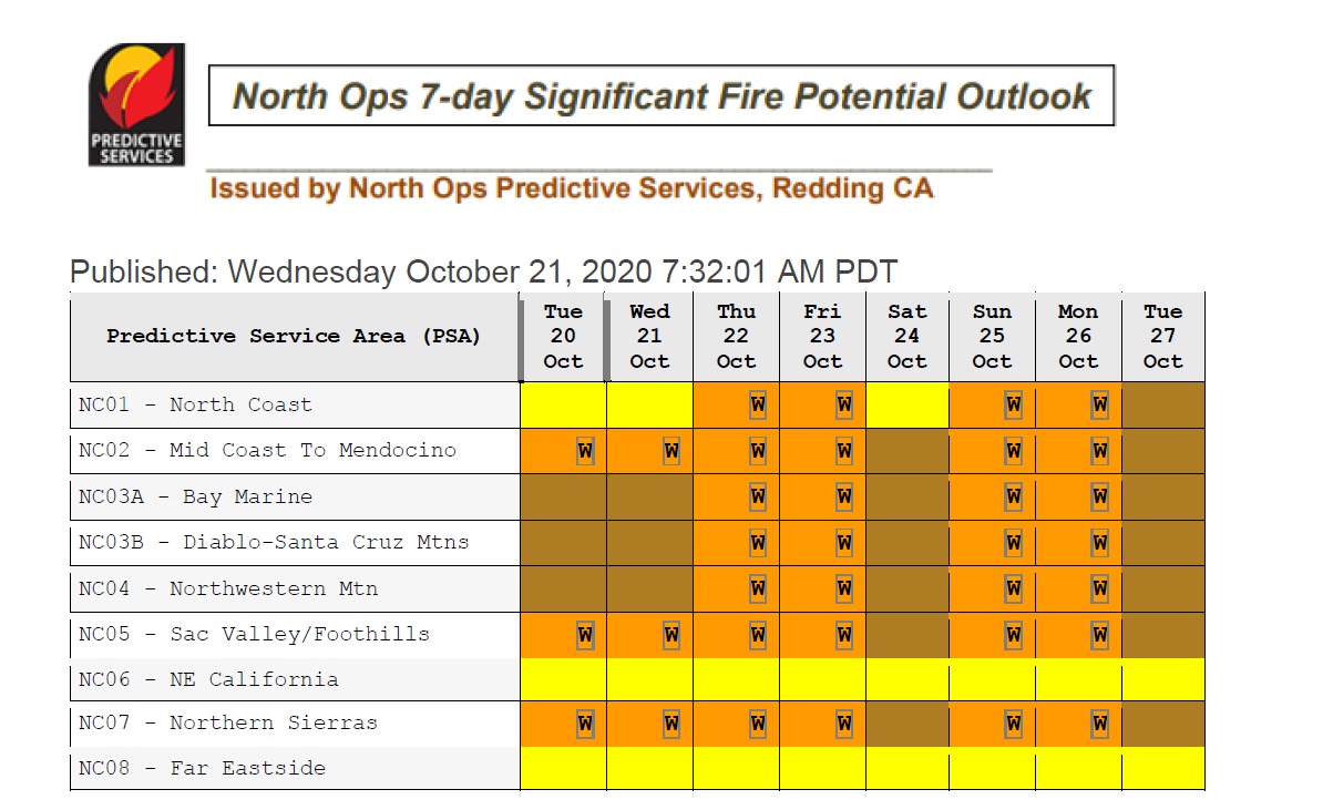
A tightening offshore gradient through Wednesday/Thursday should bring critical fire weather conditions to widespread areas of Northern CA.
Not set in stone but the most dangerous offshore wind event of the season looks to occur next weekend into early next week, especially for the Sierra Nevada. Early wind potential shows winds in the 35-45 MPH range, with gusts to 65 MPH.
Fair and dry weather with unseasonably warm temperatures will continue today, although cooler weather is forecast for this afternoon near the coast and into the coastal valleys as the sea breeze increases during the day. Interior areas will remain unseasonably warm through mid-next week with temperatures remaining in the upper 80s and 90s. Light northerly or offshore winds are expected through Monday across the northern interior before the winds increase Tuesday and into Wednesday. Wind gusts are currently expected to be mostly under 30 mph and primarily focused across the western Sacramento Valley and Northern Sierra in addition to the highest terrain in SF North Bay. Some, but not all, forecast models suggest a potential Diablo wind event starting Wednesday night and continuing through Thursday. The winds in this type of event focus primarily across the Sacramento Valley, Northern Sierra, and elevated terrain of the North and East Bay
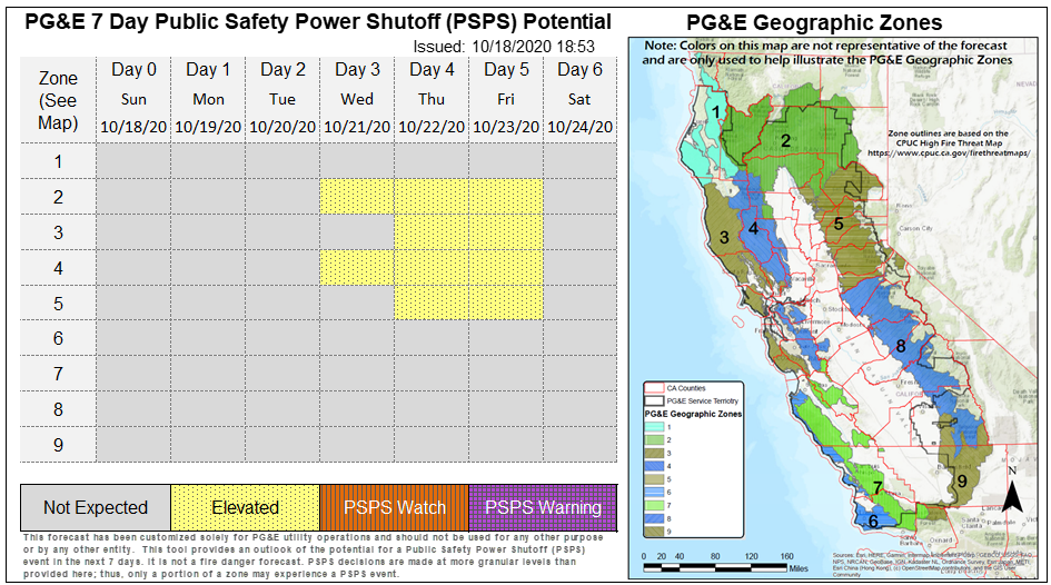
I checked PGE’s website. They have not showing a PSPS event for next week… Yet.
NWS is reporting…Critical Fire Weather Conditions Possible Late Monday Night
through Wednesday Morning…Gusty north to east winds are possible late Monday night through
Wednesday morning. Low humidity and poor overnight recoveries are also expected during this time frame. The combination of low humidity, dry fuels, and gusty winds may result in critical fire
weather conditions. Extreme caution should be taken to prevent new fire starts. Additional periods of strong, gusty winds are possible this week, particularly on Wednesday night through
Friday morning.
So it looks like a mixed bag at this point as far as this next week . Last Thursday
nights winds caused a lot of Havoc . Downed /snapped trees are everywhere you look
another session of 60 mph gusts will certainly not help anything…
**** UPDATE*** 10/18 *** 9 PM *****
Events seem to be unfolding as @anvilhead had posted . The crystal ball is still not totally clear on Severity of the winds but I found this online tonight
PGE is posting a warning for a Diablo wind event this week
At this time, the highest probability areas for observing a PSPS are in the Northern Sacramento Valley and adjacent elevated terrain, the Northern Sierra Nevada generally north of I-80, the North Bay mountains and near Mt. Diablo in the East Bay Area. At this time, the weather event is expected to begin Wednesday night and continue through Friday morning
It looks like we are on track to a blustery Mid to late week.
Dry weather will continue across the territory this week with temperatures trending slightly cooler along the immediate coast today, while interior locations will remain around 10-15 degrees above-normal before cooling later in the week. Light offshore flow is expected to return across the northern interior late in the day before increasing overnight into Tuesday morning and continuing into Wednesday. Wind gusts are currently forecast to remain under 30 mph and will be primarily focused across the western Sacramento Valley and Northern Sierra in addition to elevated North Bay terrain. A stronger offshore wind event is anticipated to develop Wednesday night through Friday morning as a weather system shifts into the Pacific Northwest before dropping south into Nevada. Periods of breezy to gusty north-northeast winds, 15-35 mph gusting up to 40-50 mph, are expected across the Sacramento Valley, Northern Sierra, and elevated terrain of the North and East Bay with potential for gusts to exceed 60 mph over favored peaks and ridges. Offshore flow will gradually diminish throughout the day Friday as high pressure weakens in response to a low-pressure trough dropping into the territory resulting in cooler temperatures, increasing humidity and a slight chance for light showers across the North and along the Sierra. High pressure will look to rebuild behind the departing system on Sunday, which may result in another round of breezy to gusty offshore flow through early next week; however, details are still limited at this time.
URGENT - FIRE WEATHER MESSAGE
National Weather Service Sacramento CA
300 AM PDT Tue Oct 20 2020
### Red Flag Warning
…Critical Fire Weather Conditions Through Wednesday Morning and
again Wednesday Night into Friday For Gusty Wind and Low Humidity…
.Gusty north to east wind combined with low humidity and dry
fuels will result in areas of critical fire weather conditions.
Extreme caution should be taken to prevent new fire starts.
Another potentially stronger period of gusty wind and low
humidity possible Wednesday night into Friday afternoon.
### Fire Weather Watch
…Critical Fire Weather Conditions Through Wednesday Morning and
again Wednesday Night into Friday For Gusty Wind and Low Humidity…
.Gusty north to east wind combined with low humidity and dry
fuels will result in areas of critical fire weather conditions.
Extreme caution should be taken to prevent new fire starts.
Another potentially stronger period of gusty wind and low
humidity possible Wednesday night into Friday afternoon
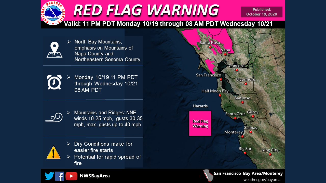
NWS SF Wed: Thursday morning will be stronger than the Wednesday, and more widespread with moderately strong offshore winds. North to northeast winds will increase in the North and East Bay Hills tonight then peak early Thursday morning with frequent gusts of 40-50 mph across the higher elevations of the North and East Bay. At the same time, RH values will plummet as an even drier airmass arrives from the north overnight. Gusty winds are also expected reach the higher ridges of the Santa Cruz Mountains then crash down towards coastal San Mateo early Thursday morning. Red Flag Warnings go into effect for the North Bay Mountains as well as the East Bay Hills and Interior Valleys starting at 10 PM this evening and for the Santa Cruz Mountains and SF Peninsula Coast starting at 1 AM Thursday morning.
A second burst of winds then occurs Thursday night into Friday morning, this time with RH values exceedingly dry around 10-20% and NO night time humidity recovery. For now this round of Red Flags is set to end Friday at 8 am.
We are then watching for a potentially stronger wind event sometime late Saturday night but more likely Sunday into Monday. The potential for a strong and damaging wind event is in the cards should the worst case scenario pan out, with strong cold advection and support through the troposphere where strong winds from aloft could mix down into the valleys, and not stay confined to the hills as often occurs. This all will occur with fuel moisture readings at record dry levels.
In the Sacramento Valley and Northern Sierra. Dry weather and above normal temperatures will continue today, with temperatures reaching 15-20 above normal across parts of the Delta and Interior. Light offshore flow will also continue with wind gusts remaining under 30 mph and will be primarily focused across the western Sacramento Valley and Northern Sierra . Tonight through Friday morning a stronger offshore wind event is anticipated to develop, as a weather system shifts into the Pacific Northwest. This will result in two periods of breezy to gusty north-northeast winds, with the first expected to produce sustained winds of 15-35 mph gusting 35-50 mph, across the Sacramento Valley, Northern Sierra, with potential for gusts to exceed 50 mph over favored peaks and ridges. With a second weaker peak Thursday evening into Friday morning, with winds expected to be around 5-10 mph less than the first push. Offshore flow will gradually diminish throughout the day Friday and become onshore overnight into Saturday. This will result in calming winds through the day Friday and seasonable temperatures. An additional weather system is then expected to move through the region Sunday into Monday. This may result in another round of breezy to gusty offshore flow increasing through the day Sunday, peaking Sunday into Monday, possibly lingering in regions through early Tuesday. However, details are still limited at this time and forecast models are not in alignment on strength and timing.
Be prepared to deal with high to critical fire danger through the end of the week, and much cooler temperatures overnight. Temperatures are finally cooling down across our region for the rest of this week. The Red Flag Warning for high fire danger has now been extended through 5pm Friday for the valley, foothills, and a portion of the Sierra. The Fire Weather Watch that was set to go into effect tonight in Trinity County has now been upgraded to a Red Flag Warning from Thursday morning through Friday morning. A Freeze Watch will go into effect overnight tonight in Trinity County, and then will go into effect for Lassen and Plumas County areas for Friday morning.
I have been reading about the Sunday event, so far it’s looking to be the first cold air activation event and potentially the strongest yet.
No rest for the weary… Flying Firewood season is in full swing or will be tomorrow again up here in the mountains
Incredible all right… I got a few other words for it @##@$
Just for the ducks of it I grabbed the text that went with your table. A little crazy to read thru it. Just bad to worse however you look at it. Headed out to help a neighbor cut out two 100 foot plus burned pines . There was 3 but the 3rd broke off last week and missed the house by a couple of feet. … We are going to try to guess what falls next and take it down today if we can… It is like a ticking clock waiting and watching once the wind kicks up
Weather:
*** High Risk Due to Gusty Winds and Low RH from the Lower Western Cascade-Sierra
Slopes to Eastern Ridges of the Mid Coast PSA Today ***
*** High Risk Due to Strong Gusty Winds and Very Low RH from the Cascade-Sierra Crest
to the Coast Wednesday Night until Midday Friday ***
*** High Risk Due to Strong Gusty Winds and Very Low RH from the Cascade-Sierra Crest
to the Coast Saturday Night Through Monday ***
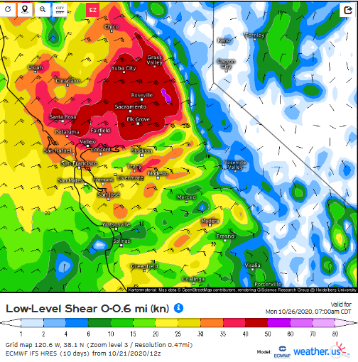
Strong Diablo wind event Sunday night into Monday. Mountain wave activity could bring about an extreme wind event to isolated-scattered areas especially along the Sierra Nevada foothills as mixing ratios are very high.
Low level shear:
This is the ECMWF extreme wind index for this day: 93 percentile for much of the area.
Can you explain what the significance is of a 93% rating? Does that reference potential speed?