NWS - SF Friday: A series of shortwave disturbances are expected to drop into the northern Rockies and Great Basin throughout the week resulting in offshore flow across
the hills, ridges and peaks of the Bay Area and Central Coast. These
offshore winds look to develop as early as Sunday night into Monday,
especially over the higher elevations of Monterey and San Benito
Counties. Periodic episodes of dry offshore winds are then expected
through the remainder of the week with Wednesday night into Thursday
looking to be potentially a moderate event. “The period from roughly Columbus
Day to Halloween is peak fire season for the Bay Area when some of
the most devastating fires have occurred. It`s been a long and
brutal fire season but we are not out of the woods yet.” This
pattern will be closely monitored in the coming days as critical fire
weather conditions may develop, especially given the lack of wetting rains.

A weather system currently approaching the territory has resulted in extensive low clouds this morning, with steady onshore flow and cooler than normal temperatures expected for today. Although no precipitation is expected with this system, a trailing weather system will bring rain to Humboldt tomorrow with a slight chance for light rain elsewhere across the far North. Otherwise, dry and mild conditions continue tomorrow for most of the territory. A warming and drying trend will then commence next week as high pressure builds across California. This pattern could also lead to the development of offshore winds around the middle of next week and will be monitored closely. Although the cooler weather and potential for precipitation this weekend will allow fuels to recover some moisture, fuels are expected to quickly dry out once warmer conditions return next week. Long-range models continue to suggest potential for a Diablo wind pattern to develop near mid-month; however, details regarding strength and timing are very unclear at present
Forecast models have been very frustrating, not in agreement with their ensembles. An extremely bizarre pattern will continue across CA, with a strong hybrid subtropical ridge across much of the state with weak surface high pressure just to the east of the ridge. The shape of the ridge makes it such that the upper level support and cold air remains east, which is causing only weak gradient driven offshore winds but with much above average temperatures. Because northern CA is much closer to the cold air and upper level support than the rest of the state, stronger offshore winds will be more likely than the rest of the state through the next week. Forecast models continue to suggest that much stronger surface high pressure may develop in a traditional fall pattern across CA, but have kicked that can further down the road with each run.
From NWS Bay Area:
" The strength of next week`s offshore flow is important for temperature forecasting, but is more crucial for the potential for another round of critical fire weather conditions. The 00Z NAM has decreased 925 mb northerly winds for Sunday night and Monday morning compared to the previous run, and the latest GFS forecasts mostly light offshore flow in the hills except for a brief period of moderate northerly winds on Wednesday night and Thursday morning. For now have alerted the fire community about warmer and drier weather next week along with light offshore flow, with the potential for stronger offshore flow at times, especially around midweek. The magnitude of offshore flow next week will be the primary forecast concern as we move through the weekend and into early next week."
So there is still so much variation for this upcoming Diablo wind event next week, and even more variation further south for Santa Ana winds. For example, the latest runs of the CMC and ECMWF would bring in a moderate-strong Diablo wind event, while the GFS is quite weak. Confidence of offshore winds is HIGH, confidence of the strength is LOW.
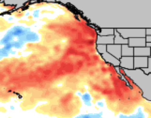
My opinion: the longer this unusual set up of an anomalous hybrid subtropical high continues, the stronger the traditional cold air driven offshore flow will be when it finally does arrive… and a huge reason is because sea surface temperatures are MUCH higher than average along much of the CA coast… which will keep the pressure lower here until a legit offshore wind event up-wells colder water.
Water temperature anomaly map (different than normal). Taken Oct. 10th. The warm “blob” of water is huge. From NOAA.
NWS SF - 0925 Mon Oct 12 North Bay Mountains-East Bay Hills and the Diablo Range- Santa Cruz Mountains-
…FIRE WEATHER WATCH IN EFFECT FROM LATE TUESDAY NIGHT THROUGH FRIDAY MORNING FOR GUSTY OFFSHORE WINDS AND LOW HUMIDITY VALUES
-
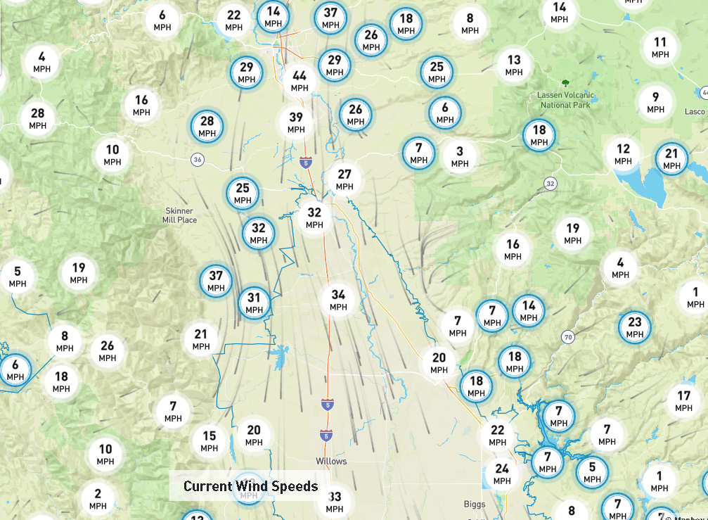
WIND…North to northeast winds 15 to 30 mph with gusts of 30 to 40 mph. Higher peaks and ridges can expect gusts of 45 to 50 mph. Strongest winds are anticipated Wednesday evening into Thursday morning.
-
HUMIDITY…Daytime humidity values will drop as low as 10 to 20 percent with little to no nighttime recoveries.
-
HIGHEST THREAT…Mountains of northeastern Napa and Sonoma Counties.
Sacramento NWS in Fire Weather Watch
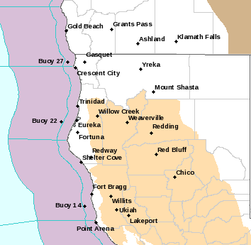
NWS Eureka
Added much of Mendocino and Lake Counties
"…FIRE WEATHER WATCH IN EFFECT FOR GUSTY EAST AND NORTHEAST WINDS
AND LOW RH FROM LATE WEDNESDAY NIGHT THROUGH FRIDAY MORNING FOR
UPPER SLOPES AND RIDGES AT ELEVATIONS ABOVE 2000 FEET…
The National Weather Service in Eureka has issued a Fire Weather
Watch, which is in effect from late Wednesday night through
Friday morning.
-
AFFECTED AREA…Fire weather zones 211…212…264…276…277
and 283. -
WIND…East and Northeast wind 15 to 25 mph with locally higher
gusts to 35 mph. Strongest winds will occur around sunrise
Thursday and Friday. -
HUMIDITY…Daytime 10-20%. Very poor recoveries each night and
morning 20-30%. Better recoveries in drainages and valley
floors. -
IMPACTS…Any ongoing or new fires will likely spread rapidly.
PRECAUTIONARY/PREPAREDNESS ACTIONS…
A Fire Weather Watch means that critical fire weather conditions
are forecast to occur. Listen for later forecasts and possible
Red Flag Warnings."
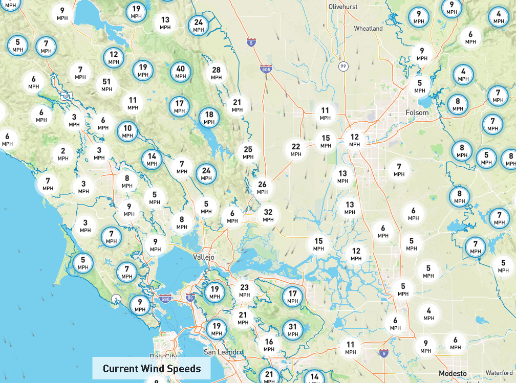
A warming and drying trend is expected this week as high pressure builds in across the state. Temperatures will reach the mid to upper 80s away from the coast today with light offshore winds generally below 20 mph. Temperatures will continue to rise through the middle of the week with daytime highs in the upper 80s and 90s for most areas by Thursday. On Wednesday, breezy northerly winds will develop through the Sacramento Valley during the day and will shift to the north/northeast Wednesday night and continue into Thursday or Friday across the northern interior. The strength of these winds remains somewhat uncertain, but gusts at or above 50 mph are looking possible in elevated terrain in the North Bay and Northern Sierra. Lighter winds return this weekend along with cooler conditions near the coast. Fire danger will rapidly increase mid to late this week as dead fuels quickly dry out under warmer and drier conditions and offshore winds.
pge is reporting to prepare for a potential Diablo wind event lasting from Wednesday through Thursday aside from the Northern Sierra that may experience Diablo winds through Friday morning. The current forecast shows PSPS Watch in Zones 2, 3, 4, 5, 6 and 8 for the upcoming event.
At this time, the highest probability areas for executing PSPS are the Northern Sierra Nevada foothills, the mid and higher elevations in the Sierra generally north of Yosemite (northern portion of Zone 8), the North Bay mountains near Mt. St. Helena, small pockets in the East Bay near Mt. Diablo, the Oakland Hills east of Piedmont (generally between highway 24 and Upper San Leandro Reservoir), the elevated terrain east of Milpitas around Calaveras Reservoir, as well as portions of the Santa Cruz and Big Sur mountains. This is not expected to be a widespread event in the Bay Area at this time. The weather event is expected to begin Wednesday evening and continue through Thursday morning. A second period of winds may develop Thursday evening through Friday morning in the Northern Sierra
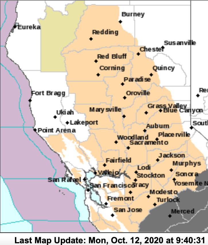
Fire Weather Watches are being upgraded to Red Flag Warnings currently.
Synopsis: the big trough over the upper midwest will erode the eastern side of a large subtropical ridge over CA. The latest run of the ICON & CMC bring a large swath of record snowfall to the upper midwest, as far south as Nebraska. The long wave trough over the midwest will continue, shifting slightly west which will promote offshore flow and dangerous fire weather conditions across Northern CA through much of the rest of the month.
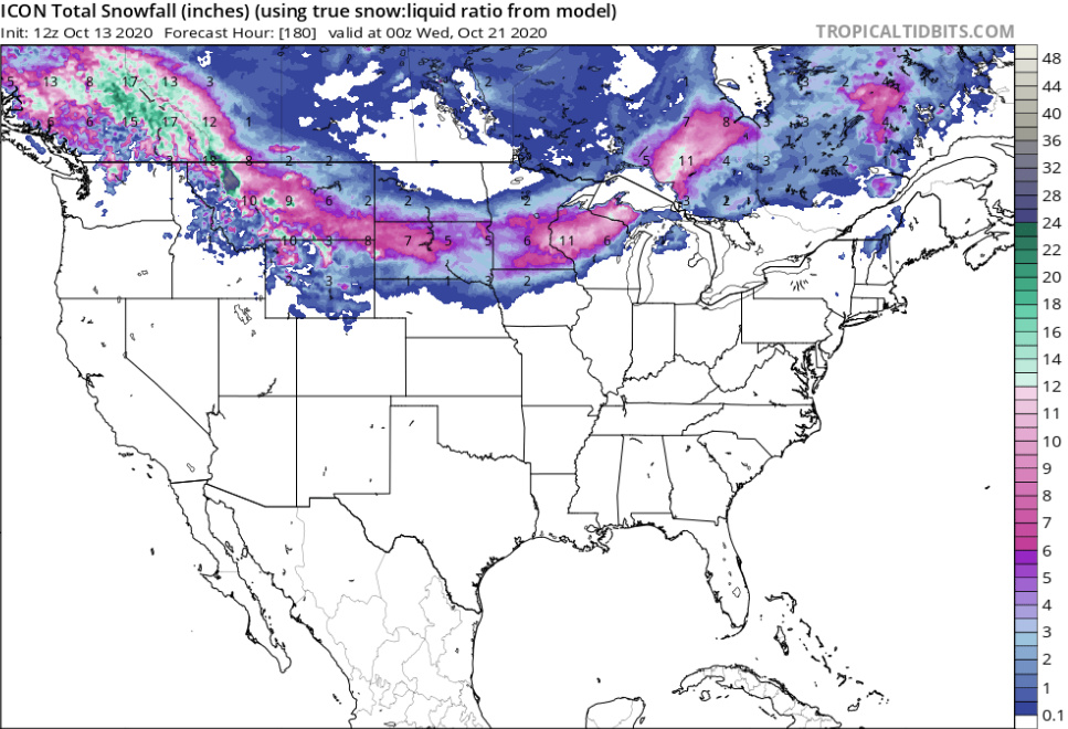
This record breaking snowfall through the next week will promote constant surface high pressure across the upper midwest. Later this month the trough axis continues to erode the high over CA and provide upper level support and advect that cold air from the early season snowfall in that region, across the Great Basin.
For Friday a critical gradient will be present across Northern CA with SFO to WMC as high as -16.5 mb by 12z Thursday. Red Flag warnings are in place and terrain favored areas above 3,000’ could see wind gusts approach 55-60 MPH.
After this weekend please monitor fire wx conditions because no rain is anticipated and the trough over the midwest deepens further west allowing for possibly extended critical fire weather conditions, likely favoring the Sierra Nevada for the worst fire wx conditions later this month.
Prepare for a Diablo wind event lasting from Wednesday through Friday morning. There is now high confidence in a Diablo wind event occurring and Federal forecast agencies are aligned this will be a high risk event. The National Weather Service has issued multiple Fire Weather Watches from Wednesday through Friday, which will likely be upgraded to Red Flag Warnings in the next 24 hours. The Federal Northern Operations Predictive Services is also forecasting high risk of significant fire potential for most of Northern CA Wednesday through Friday as well. The NOAA Storm Prediction Center (SPC) is also showing critical fire weather in Northern CA starting tomorrow.
The highest probability areas are the Northern Sierra Nevada foothills, the mid and higher elevations in the Sierra generally north of Yosemite , pockets of elevated terrain adjacent to the west side of the Sacramento Valley, the North Bay mountains near Mt. St. Helena and Morgan Valley, small pockets in the East Bay near Mt. Diablo, a pocket of the Oakland Hills east of Piedmont (generally between highway 24 and Upper San Leandro Reservoir), the elevated terrain east of Milpitas around Calaveras Reservoir, as well as portions of the Santa Cruz and Big Sur mountains. Portions of Humboldt County are also being considered generally between the communities of Bridgeville and Blocksburg. This is not expected to be a widespread event in the Bay Area at this time. The weather event is expected to consist of two periods of winds. The first period of wind starts Wednesday during the day and will strengthen after sunset and continue into Thursday morning. After a brief lull mid-day Thursday to afternoon, a second period of wind develops Thursday evening through Friday morning across Northern CA. Forecast models have trended a bit stronger for the second period of winds Thursday and Friday. Winds are expected to relax by mid-day Friday. The start of the event is more than a day away so event details may change as forecast models evolve.
And May I add that the possibility of fire season running on and on is not a pleasant one. Living up in the trees in one of these fire/wind prone areas is just a different experience than it used to . Everything I read points to your conclusions. Can I be polite and still hope you/we are wrong. Living with one eye always on the horizon gets tiring 
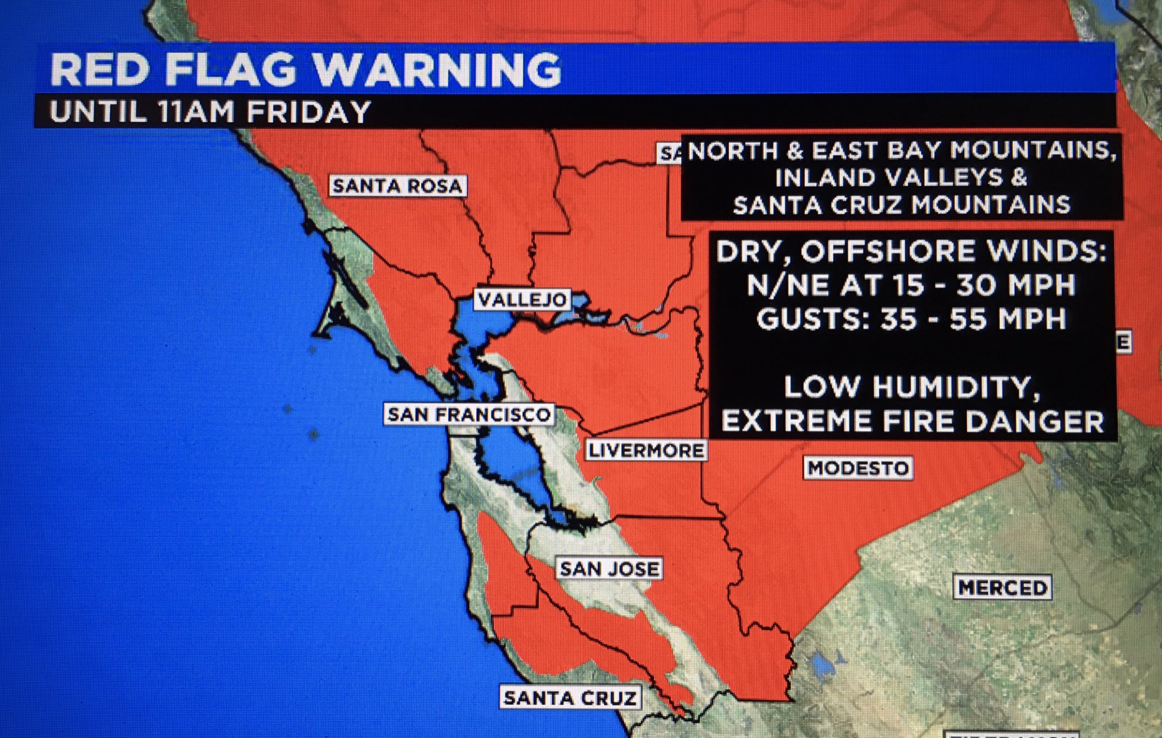
Many red flag warnings already posted
https://forecast.weather.gov/wwamap/wwatxtget.php?cwa=rev&wwa=red%20flag%20warning
Model output indicates the KWMC to KSFO pressure gradient could reach 16-17 mb during this time frame. In addition, an extremely dry air mass is projected to move in from the north and northeast beginning this afternoon. The net result will be critical fire weather conditions, beginning with the increased offshore flow this morning and then becoming significantly more extreme this evening into Thursday as relative humidities plummet and winds ramp up. Relative humidity values are projected to drop into the single digits and teens, with very poor overnight recoveries. A Red Flag Warning remains in effect for the North Bay mountains and valleys, the Diablo Range and East Bay hills and valleys, and the Santa Cruz Mountains from 5 AM PDT today to 11 AM PDT Friday. That said, some model output soundings over the North Bay indicate possible development tonight of a wind and thermal structure consistent with mountain wave amplification and resulting enhancement of downslope winds. Basic set-up does not appear as conducive to this as that associated with the October 2017 Wine Country Fires, but will nonetheless need to continue to monitor.
In the upper Sac Valley and the eastern edge of August NE Zone, saw some great recoveries last night but already by 7am some of the IRAWS are already showing 30% drops from evening peaks. IMET on August NE is expecting RH down to the teens on the incident, with northerly winds through the day and then around 1700 winds shifting out of the NE and growing more intense with gusts to 25 over night.
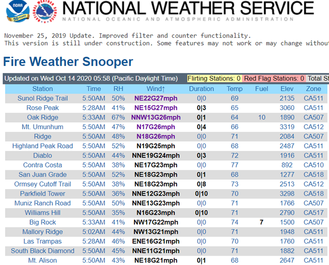
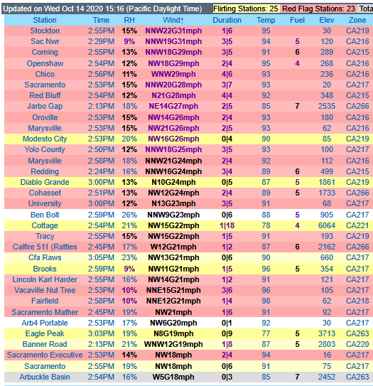
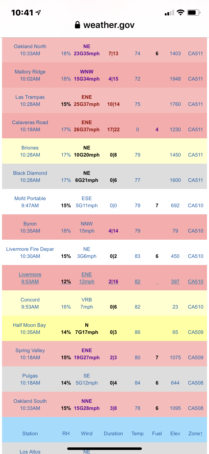
NorCal snooper - https://www.weather.gov/lox/fwmV3?wfo=sto&net=1,2
Underwater volcano erupt??
Last evening, we observed several weather stations report wind gusts in excess of 50 mph with peak gusts near 65 mph. Confidence remains high that this diablo event will continue with a second wave of gusty winds this evening into tomorrow morning, and Federal forecast agencies are aligned this second period of winds will be a high risk event. The National Weather Service has several Red Flag Warnings in effect through Friday due to a combination of gusty offshore winds and critically dry conditions. The Federal Northern Operations Predictive Services is also forecasting high risk of significant fire potential for most of Northern CA today through tomorrow as well. At this time, the highest probability areas for continuing is in portions of Humboldt (generally between the communities of Bridgeville and Blocksburg), and the Northern Sierra Nevada foothills, the mid and higher elevations in the Sierra generally north of Yosemite , The west side of the Sacramento Valley, the North Bay mountains near Mt. St. Helena and Morgan Valley, small pockets in the East Bay near Mt. Diablo, a pocket of the Oakland Hills east of Piedmont (generally between highway 24 and Upper San Leandro Reservoir), the elevated terrain east of Milpitas around Calaveras Reservoir, as well as portions of the Santa Cruz mountains. The weather event is expected to consist of two periods of winds, with the first period of winds having past overnight and expected to continue through this morning. After a brief lull mid-day today, a second period of winds develops this evening through tomorrow morning across Northern CA. Forecast models indicate this second period of winds should be generally weaker, especially for areas south of the I-80 corridor. Winds will begin to diminish tomorrow morning, and all areas will return to seasonable conditions with cooler temperatures through the weekend