
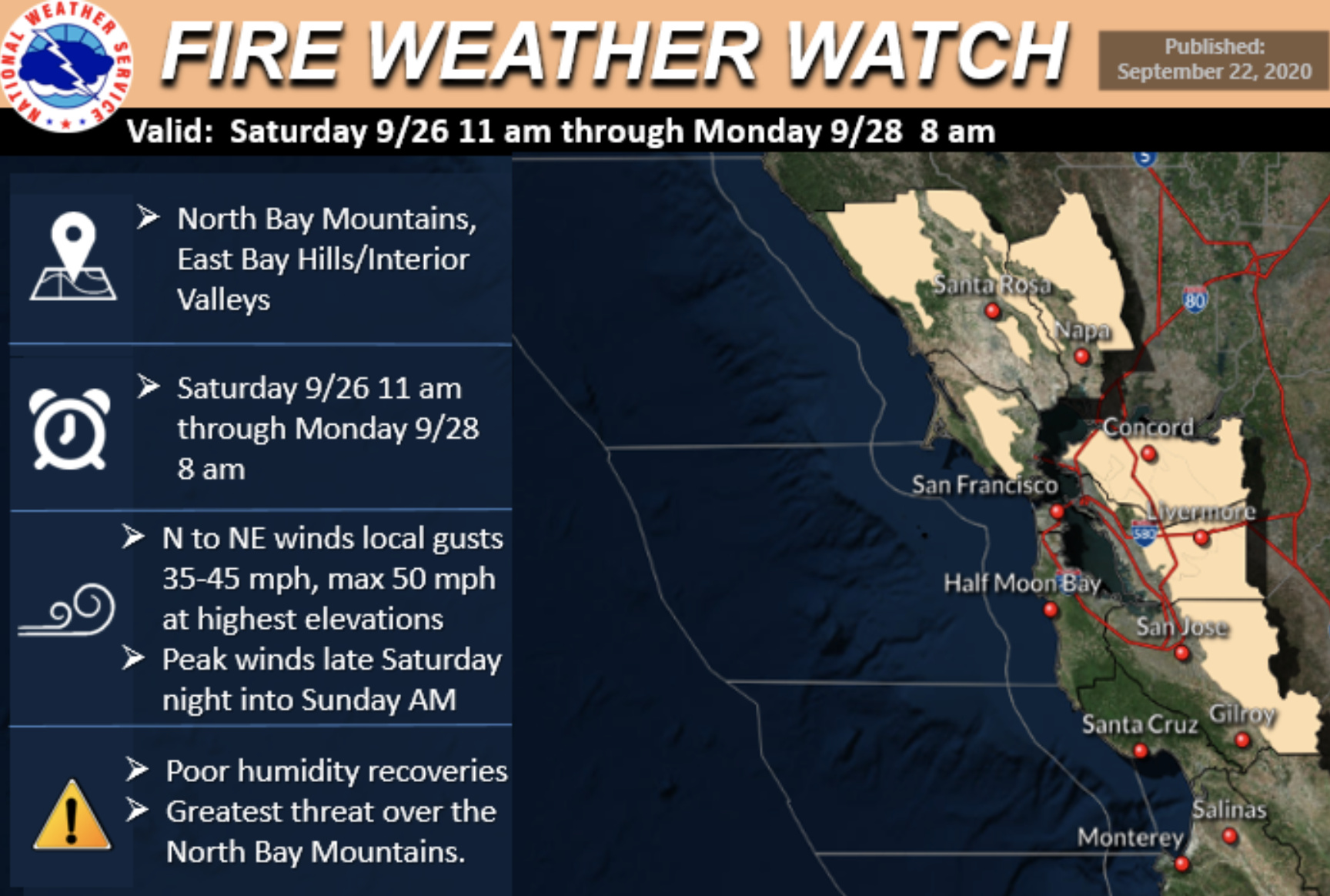
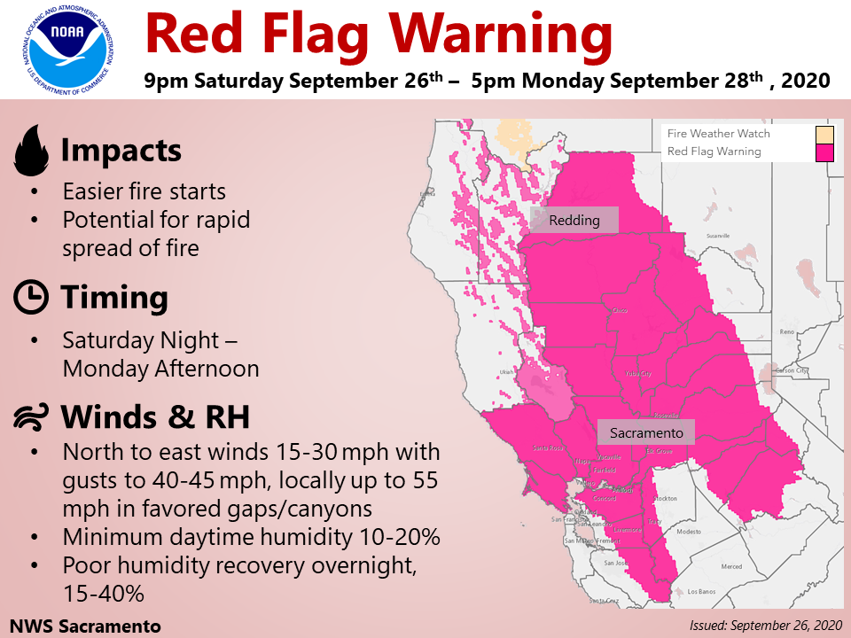
NWS Sacramento:
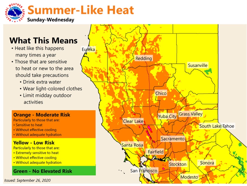
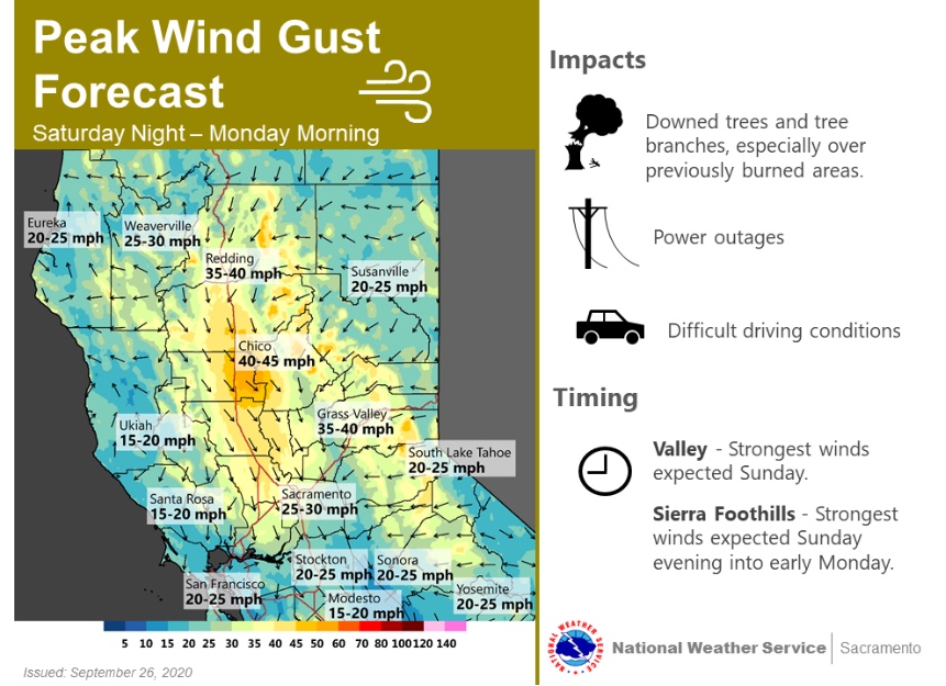
“High pressure builds over interior Northern California over the weekend into early next week. This will result in a warming trend with above normal temperatures. Highs by Monday/Tuesday in the Central Valley will be in the upper 90s to around 102. Moderate heat risk is possible in the Valley and surrounding foothills. This heat could impact sensitive groups. Breezy north to east wind develops Saturday and continues into early Tuesday. Combination of wind, hot temperatures and low humidity will bring elevated fire weather conditions. A Fire Weather Watch is in effect from Saturday morning through Monday morning including the west side of the Sacramento Valley, the Coastal Range, the Sierra Nevada foothills and the Delta. Please practice fire safety.”

Forecast on track starting Saturday afternoon for above average temperatures 10-20 degrees above normal, combined with RH 10-20%, and offshore winds above 3,000’ 15-25 MPH, strongest in the Sierra Nevada… where gusts could approach 45 MPH.
This is a gradient and subsidence driven event. There is no cold air and upper level wind support so winds will not mix down to low elevations. The lack of winds at low elevations and aloft will probably contribute to very little smoke distribution // or different layers of smoke. Plume dominated fire behavior with rotating columns where wind aligns could occur.
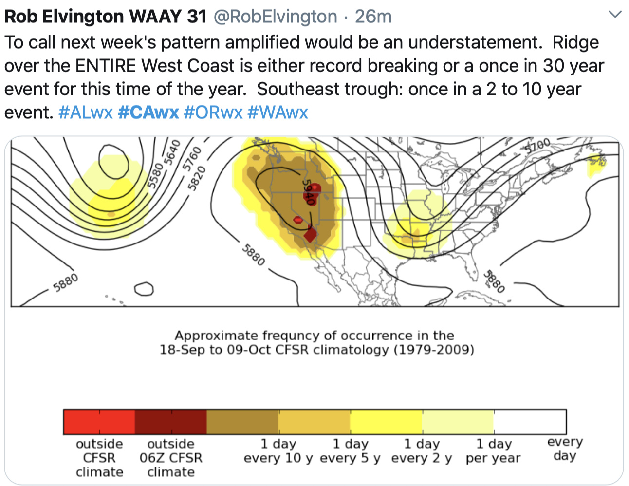
There is significant questions to be asked about what happens after this ridge builds in, and not enough consistency to decipher what comes next.
I am very sorry for posting again and sounding redundant, but the 12z run of the ECMWF has shifted the trough about 300 miles west in a dramatic shift over the last two runs. Check out this comparison. If this trend continues we could see some additional upper level support and cold air advection for stronger winds.
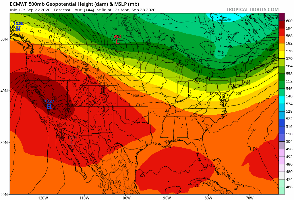
This run also now shows the hottest day on Wednesday… wow

PG&E Meteorology is closely tracking the potential for dry northerly winds to develop Saturday evening and continue into Monday morning across Northern CA. The event start is still about 60 hours away from this time (Sept. 24, 8 am) and as we get closer, some details regarding strength, timing and location of the event may change if models evolve. The northerly winds will coincide with very hot temperatures and the National Weather Service has issued a Fire Weather Watch for portions of Northern CA valid from Saturday through Monday. The Northern Operations Predictive Services has also forecast ”High Risk” for strong and dry offshore winds combined with dry surface fuels.
Last time there was a PGE PSPS event the bear fire jumped it confines. Without power most of us have loss the ability to see what is going on or receive warning . Brought some pretty big problems for those in the affected areas.
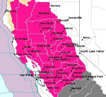
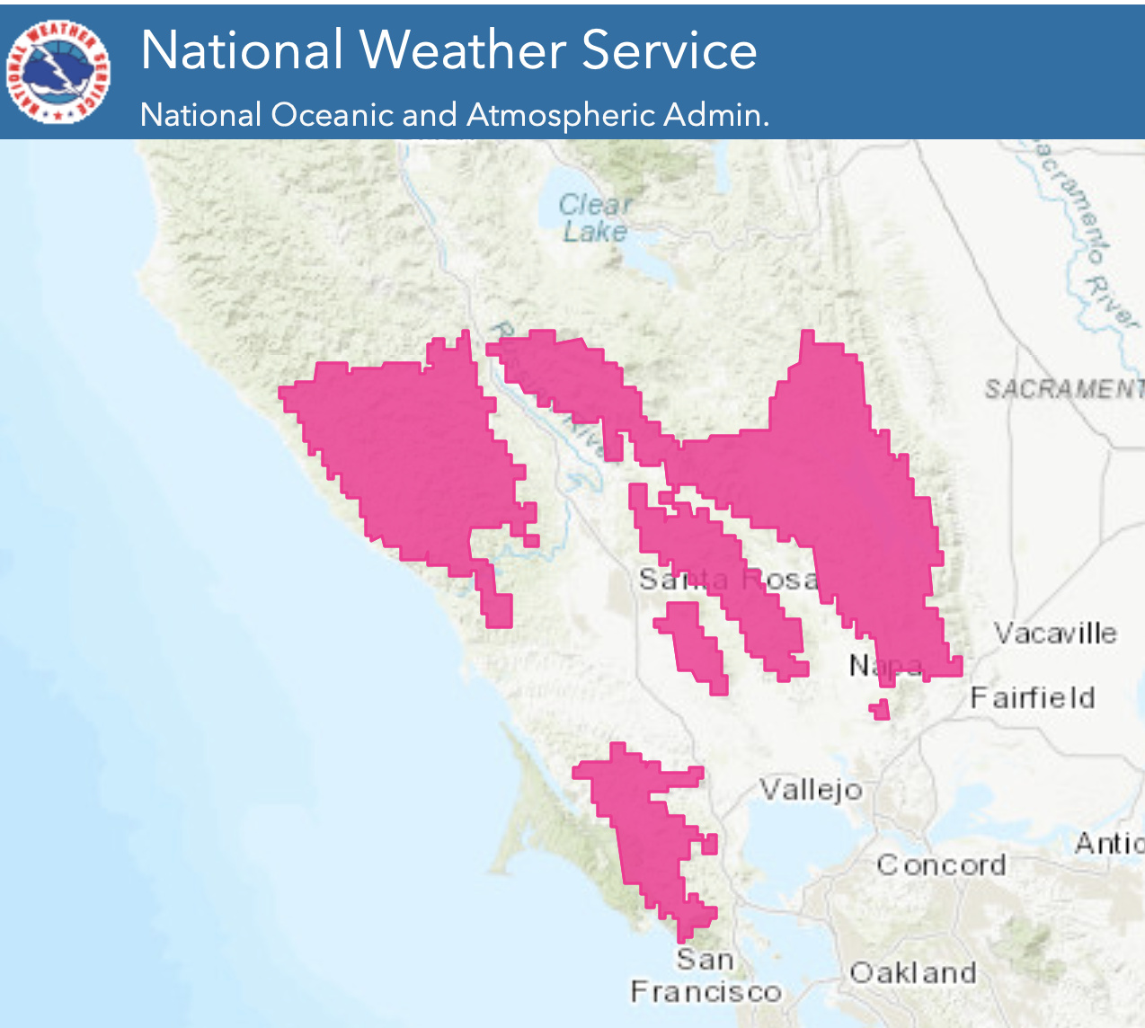
NWS SF: 01:50 PM Thursday… Anticipate for the current Fire Weather Watch to be upgraded to a Red Flag warning sometime early Friday
The GFS and ECMWF are in agreement that the PAC mid-level ridge will begin building Saturday and introducing 591dm heights to portions of our CWA that day before becoming more widespread on Sunday and Monday. Once mixing has gone into full effect, offshore flow will quickly dry out the higher terrain locations along the East and North Bay as a tight pressure gradient sets up over northeast California. Both the MTRWRF and NAM runs today pick up on both the drier air advection and the wind shift picking up Saturday evening, with 925 hPa winds progged around 35 mph and some locations like Mt. Saint Helena, Mt. Diablo, and Mt. Tamalpais progged to reach gusts of up to 50 mph. Expecting the North and East Bay hills to experience gusty conditions Saturday night and into Sunday morning as a result. Poor overnight humidity and temperature recoveries will carry over through the rest of the weekend and into Monday, with Sunday and Monday progged to be the warmest days of this initial part of the warming trend. This upper-level ridge is expected to continue to build through Monday and into the early part of next week, allowing for interior temps to reach the 100-105 F range, while coastal locations will run between the 76F-86F range. Anticipate for the current Fire Weather Watch to be upgraded to a Red Flag warning sometime early Friday as a result.
More of a longer range outlook here but the La Nina setting up in the Pacific is starting to look stronger rather than the weaker prediction. We could be going into drought models for NorCal and SoCal by next summer.
NWS SF - Friday
Have upgraed the Fire Wx Watch to a Red Flag Warning, set to
start at 9 pm Saturday night for the North and East Bay hills as
well as the East Bay interior valleys. The 00z/06z NAM runs have
trended slightly stronger with widespread 925 mb winds pegged at
40 kt. As is usually the case these winds will first show up
across the Napa hills sometime around 9-10 pm Saturday night.
Humidity values will start out fairly moist, above 30% but drying
will persist all night. Please note most locations below 2000 feet
will feel little or no wind Saturday night but the winds aloft
will be blowing strong and acting to dry the airmass out. By
Sunday morning the dry air will really be filtering into the Bay
Area as north winds come down the Sac valley and spill into the
Bay Area. Expect no fog Sunday morning, except perhaps from
Monterey southward. The offshore winds will keep drying things out.
The models have trended stronger with winds on Sunday night and by this time humidity values will be in the teens, almost regionwide.
The main trough axis is now progged farther westward over the
Rockies. This is dropping a little more cool air into the Great
Basin but more importantly giving some upper support. In
addition, the stronger surface pressure gradient is over the
Sierra. And finally the 595 dm high to the northwest of Cape
Mendocino will induce some subsidence aloft as well. Model cross
sections now show north to northeast flow through much of the
depth of the troposphere. To be clear this event is nowhere near
the strength of the 2017 wine country, 2018 Camp or the 2019
Kincade fires. However the setup is still critical. In fact by
Sunday night with the main sfc gradient over the Sierra we will
get a pure east wind event.
Though not progged explicitly by the models as east winds come off the Sierra they will make a beeline towards Mt Diablo and the North Bay. Again there will be no humidity recovery Sunday night and the models show east winds driving all the way to the coast and offshore. The setup is lacking cold advection but this is the type of pattern where we can see winds mix down into the I-880 corridor/Berkeley hills by Monday morning as well as to the lee of Mt Tamalpais with coastal gaps such as Hwy 92 to Half Moon Bay seeing locally strong east winds as well.
All that to say the Red Flag Warning goes through 8 am Monday.
In case it hasn’t been posted yet… All of the fire watches have been upgraded to Red Flag warnings with the exception of far North West CA. I have been watching closely over the past few days for interior Mendocino County to get a warning. It seemed as if we were going to not get one, but as of 5 pm most of Mendocino County has a Red Flag. PGE has also updated there PSPS watches to include zones 2,3,4,5,8,9. No idea yet where the PSPS is going to effect as of the time of this post.


NWS - SF Tuesday: The large upper level high remains anchored over the West. This upper ridge is much stronger than normal for this time of year. In fact, the latest EPS and GFES depict it being several standard deviations above normal. Its also interesting to note that the ridge is robust and extends northward into W Canada and E Alaska. The 00Z runs also show a re-strengthen of the ridge by Wednesday and more so on Thursday. This building upper ridge will help to squish any remaining marine layer. 850 mb temps remain above normal and warm a few more degrees. So what does this mean for the Bay Area? The brief cooling near the coast today will be reversed on Wednesday and Thursday. Inland heat will increase over the next few days. Temperatures across the interior were bumped up a few degrees on both Wednesday and Thursday. Could see a few more places reaching the low 100s on Thursday than previously forecast. Some of the MOS guidance pushes temperatures to near 106 for Livermore on Thursday. Heat Risk concerns increase on Wednesday with interior locations in the moderate to high category. By Thursday, a heat advisory may be needed for the interior. The bigger story for the next few days over the Glass Fire will be the re-building of the ridge midweek. Hot and dry conditions will get turned up a notch Wednesday and a little more on Thursday. Additionally, winds at 2500 increase Wednesday night and Thursday, especially the Napa/Sonoma county line. Minor cooling is expected on Friday as the ridge eases a tad. Additional cooling expected over the weekend as the ridge breaks down even further.
Delving into fantasy land the ECM/GFS get rather interesting late in the weekend and next week. Newly formed Tropical Depression 18-E (S of Baja) tracks northward on the western periphery of the weakening ridge. As this happens an anomalously low upper level trough moves into the PacNW next week. The leftover tropical moisture gets advected eastward and possibly into over CA as the PacNW trough moves eastward. If youre having a flashback its eerily similar in the broader sense to the second push of moisture that brought a few lightning strikes to the region around August 22/23.
Fresh round of Fire Wx Watches for the Dolan and Glass Fires:
https://forecast.weather.gov/product.php?site=mtr&issuedby=MTR&product=RFW
@anvilhead Looks like there is potential for rain in the forecast for Northern areas. (specifically around the Glass Fire)Do you know if this is a potential lighting scenario like we had in August or does this system show more precipitation?
Per Dr. Swain on Weather West about 5 hours ago…
Everything from a bust to a major precip event remains on the table, and there’s no more clarity than yesterday. (Also, still a slight risk of dry lightning on Tues/Weds before the possible rain event Fri-Sun).
He did mention more recently that he’s thinking I-80 north the best chance for good rain.
RFW just issue for now through 0600 tomorrow for areas of Glass Fire in Sonoma County.
North Bay Mountains-
403 PM PDT Sat Oct 3 2020
…Hot, dry, and locally gusty conditions will persist through
this evening with poor recoveries and gradually weakening winds
overnight…
…RED FLAG WARNING IN EFFECT UNTIL 6 AM PDT SUNDAY FOR DRY
CONDITIONS AND GUSTY WINDS ABOVE 1000 FEET FOR FIRE WEATHER ZONE
507…
THE NATIONAL WEATHER SERVICE IN San Francisco HAS ISSUED a Red
Flag Warning…WHICH IS IN EFFECT until 6 AM PDT Sunday.
-
AFFECTED AREA…North Bay mountains above 1000 feet.
-
WIND…Northwest 10 to 25 mph with gusts 25 to 35 mph.
-
HUMIDITY…15 to 25 percent but locally 8-12 percent with
little or no nighttime recovery in the hills. -
HIGHEST THREAT…Active portions of the Glass Fire or those
areas with unsecured or open fire line.
There is a slight chance of dry lightning along the warm frontal boundary probably Wednesday night-Friday time frame but a solid chance of wetting rains mainly from the Bay Area and points north. I would expect the models to continue to trend this big upper level trough towards more of an inside slider with less precipitation.
Regarding hurricane Marie, located approx 1,200 miles west southwest of the southernmost Baja Peninsula, the cyclone continues to weaken as it moves northwest at 7 mph while crossing over cooler sea surface temperatures (per 8 am NHC discussion). Earlier global model output had showed potential entrainment of remnant moisture into the mid-latitude deep layered long wave trough arriving late this week, however the 00z ECMWF and 12z GFS have backed off on this forecast. Progression of the mid-latitude jet stream and advancing long wave trough reaching the West Coast late this week appears to be too fast
to allow entrainment of remnant cyclone moisture. There is still a
fair amount of sub-tropical/mid-latitude moisture in the long wave
trough thus offering good rain potential when it arrives here late in the week with a strong jet stream push behind the trough with a
neutral to negative tilting of the 500 mb trough. Thus current
forecasts advertise a chance of rain for late week over the Bay Area and north Central Coast, for the near to medium term this is of
course excellent news for fire suppression efforts. Though still
have to watch for returning offshore winds, warming and drying
though through October as is often the case in the fall season.
