North Ops Weather-2020

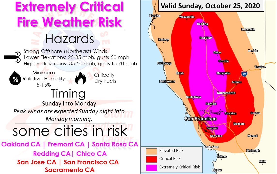
NWS SF Saturday: Very cold air will spill into the Great Basin setting up a strong surface pressure gradient across the Sierra. Pressure gradients rapidly increase to about 18-19 mb over the next 24 hours. Initial shot of north winds will work down the Sac Valley today and should reach the Napa hills by early afternoon. Strong wind gusts in excess of 50 mph will hold off until 4-7 pm.

We dont often get to see true synoptic frontal boundaries that are so clearly defined. The airmass change will be abrupt as very dry air filters over the region and it wont discriminate between the hills and valleys.

The northeast winds will howl across much of the Bay Area. Models show strongest wind potential will be with the initial burst of winds. Model cross sections show very strong winds aloft with downward sinking air.

There wont be any inversion of note to keep the strong winds from mixing down. In terms of magnitude if memory recalls the models were showing perhaps stronger wind strength during the 2017 wine country and 2019 Kincade fires but this event looks to be more widespread. Another noted difference is the strong east winds over the Sierra region west of Tahoe. During these setups those winds take a straight beeline towards Mt Diablo and then under the right conditions will drop down into the East Bay hills region above the 880 corridor. Wind damage still appears likely overnight as the high momentum wind gusts will take out drought and fire weakened trees/limbs/powerpoles across the region.

Unlike normal offshore wind events we dont expect the strongest winds to be confined to the hills as the atmospheric profile will be conducive to mixing those winds down.

Wind gusts 40-50 mph at lower elevations, downwind of the hills (East Bay hills, coastal Marin, Pacifica/Half Moon Bay) with expectation for gusts 60-70 mph for the higher elevations of of the North and East bay hills, roughly above 2500 feet. Heavy fuels remain at or near record dry levels.

Long range spotting, record dry fuels, wind gusts 50-70 mph and humidity in the teens would all be valid model inputs along with a highly turbulent/unstable boundary layer. Expect egress to be blocked and normal comms to potentially be disrupted.

4 Likes

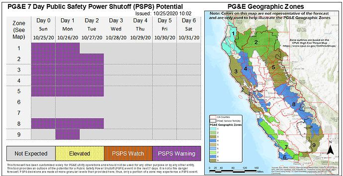
he latest PSPS forecast now indicates PSPS Warning status for all zones except Zones 6, 7, and 9 today, 6 and 7 tomorrow, and 1, 6, 7, and 9 Tuesday. Forecast confidence is high that this event will be stronger and more widespread than previous events this season. The areas with the highest probability of being affected by PSPS for this event are the adjacent terrain surrounding the Sacramento Valley, almost all of the Sierra, as well as higher terrain of the Bay Area, including the Santa Cruz Mountains, and portions of southern Kern.
Quiet weather to start this morning with marine clouds along the coast and neighboring coastal bays and valleys that should rapidly mix out from north to south today as dry air begins to filter in across the state. A strong fall weather system is on track to move through the territory starting this afternoon and into Monday, with Zones 2, 3, 4, and 5 experiencing breezy to locally gusty winds into Tuesday morning. A few isolated showers are possible over the Southern Sierra and far South as the weather system drops south through the state, but continued dry weather is expected elsewhere across the majority of the territory. As this weather system moves in today from the North, strong and north-northeast winds are expected to increase during the afternoon and evening, peaking overnight into early Monday. Winds are expected to decrease by the afternoon on Monday, although the offshore winds will remain breezy into Tuesday morning, primarily across the Central and Northern Sierra in addition to the North Bay mountains. Sustained winds of 15-35 mph and widespread gusts to 40-60+ mph are possible during the peak of the event. Stronger winds gusts above 70 mph are possible across wind favored peaks and gaps in the Sierra and North Bay. Relative humidity values will also plummet to the single digits or teens during the onset of gusty north-northeast winds, resulting in critically dry conditions and receptive fuels for ignition. Winds and associated fire danger is expected to decrease on Tuesday afternoon, followed by lighter winds under fair skies for the rest of the forecast period. Fire danger remains seasonably high

4 Likes

Marin Add : 2nd LG TF + additional WT
MRN Charlie ST
2nd Dozer
NBIMT

2 Likes

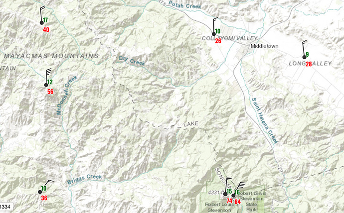
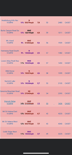
Mt. St. Helena - 74 mph and 15%.

5 Likes

It’s howling, no doubt, but I believe that is the peak gust.

Mt St Helena West (PG132) Severity:87

TIME RH WIND TEMP FUEL
06:50PM 15% N59G72mph 46
05:50PM 17% NNE31G43mph 47
04:50PM 23% NNE29G44mph 49
03:50PM 22% N32G39mph 49
02:50PM 43% NNE21G33mph 48
01:50PM 42% N18G26mph 48
12:50PM 55% NNE27G36mph 46
11:50AM 67% NNE30G34mph 44
10:50AM 82% NNE30G35mph 43
8 Likes

4 Likes

Alpine Meadows

3 Likes

PG&E site said it was only 105 mph :rofl:
(oops…they just changed it)

3 Likes

Where did you see this info I’m seeing low RH in the area where I’m looking

Scratch that

3 Likes

Dated Feb 09 2020?

Wow! Take a look at this mornings “humidity recoveries”!
https://www.weather.gov/lox/fwmV3?wfo=sto&net=1,2

7 Likes

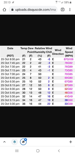
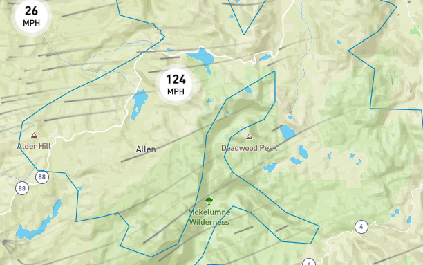
Kirkwood resort currently has 124 mph gusts

image

Strong, gusty north-northeast offshore flow was observed across the north half of the territory overnight and will continue through midday before diminishing this afternoon. However, locally gusty offshore winds will remain present across portions of the central and northern Sierra and North Bay mountains through tomorrow morning. Sustained winds of 15-30 mph and localized gusts to 35-50+ mph are possible through this morning and across the aforementioned locations again overnight. Relative humidity values will remain largely in the single digits or teens during the day with very little recovery across elevated locations overnight, resulting in critically dry conditions and receptive fuels for ignition. Winds and associated fire danger is expected to decrease tomorrow afternoon, followed by lighter winds under fair skies

6 Likes

A return to quiet weather for the next week or so in NorCal . And I for one am glad for a break from the winds of earlier this week. Fair and dry weather will develop today and continue through the weekend marked by cool nights and mild to warm afternoons with daytime highs running anywhere from 5-15 degrees above-normal. Apart from some residual northeast winds across higher terrain this morning, winds will remain light across the territory through the weekend. A shift towards cooler weather looks possible towards the early to middle part of next week with the passage of a weak weather system that may produce some light showers across the far North; otherwise, no significant precipitation is anticipated over the next 7 days.

9 Likes

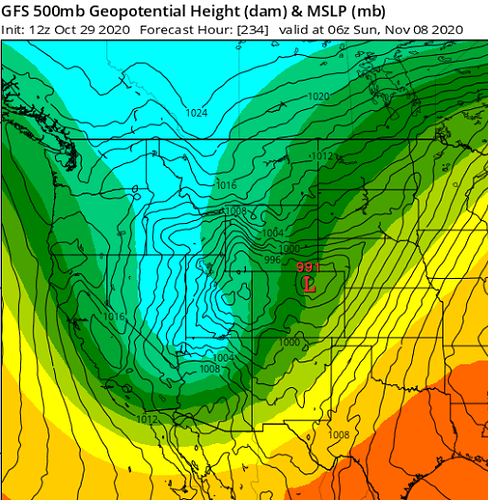
And a possible strong north/east wind event 11/-11/9. According to the Euro similar to the 11/8/18 event- strong wind event for the entire state…

8 Likes

Well we will hope that does not work out that way. Still cleaning up from the 11/08/18 event :worried:

10 Likes

This is so aggressive. Will have to see if it trends more inside.

3 Likes

So this plays out on Nov 8th? Nice…

3 Likes

What does that mean agressive ?

3 Likes