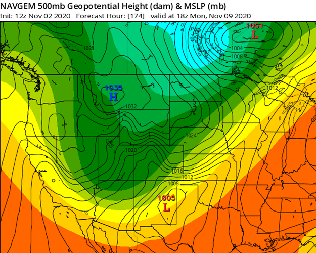
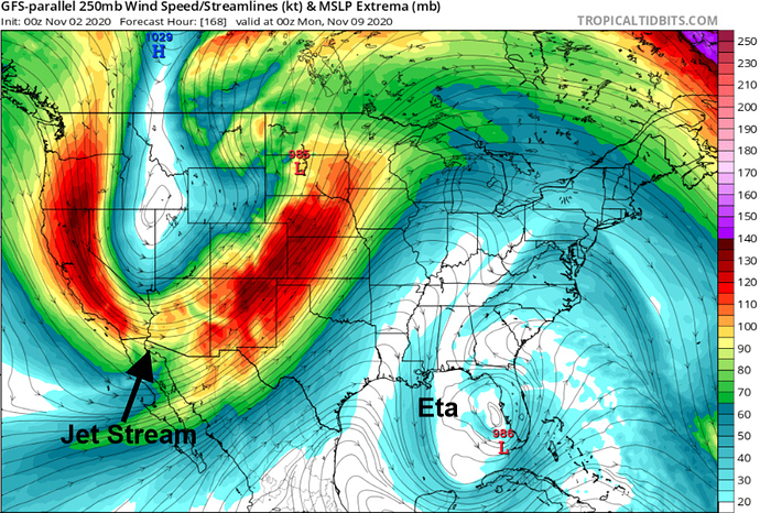
It means that the trough is very cold and very sharp. Sharp as in it digs south into Arizona, dragging the jet stream with it. We will need to monitor to see if models take it a little more inside for a possible severe offshore wind event.
Agree- not all of the models have bought off on it, the GFS wants to bring some light precip down the east side. I think there are two issues right now; one the hurricane- that will throw the models off and the strength of the current HP. If it does play out as depicted, it looks really strong for the entire state…
Ok make more sense , thanks for breaking it down
GFS is trending more towards the inside slider scenario. This would seem to mimic the last system that came through. Any precipitation would be confined to the NW portion of the state and the higher elevations of the Sierra and the Eastside. Following it would be a sharp offshore gradient with plenty of cold air support. Beyond that it appears the pattern re-loads and repeats… Still a lot of time before that plays out and there is a real chance that the pattern takes a more over water trajectory and brings some meaningful precipitation to the north state… I guess we will see…
Cast my vote for rain…
Fair and dry autumn weather continues through early next week as high pressure builds in and encourages a gentle warming trend for inland areas. Interior daytime highs are favored to climb to around 10-15 degrees above normal, with more seasonable but still above average temperatures closer to the coast. More moderate temperatures are expected by midweek as a weak weather system brushes the far North, bringing a slight chance of showers to the far North coast and the return of onshore flow. Long range models show a second, stronger system impacting the territory late next week, bringing significantly cooler weather and a chance for wet and unsettled weather. November, rain chances are on everyone’s mind and just might be in the forecast. A system will drop in from the north into NorCal on Friday & Saturday. What will it do, for sure? It will bring extra cloud cover and much cooler temperatures. What ‘might’ it do? Bring rain. Chances are still up in the air at this point. Both mountain & valley rain look ‘possible’ but not guaranteed. Only the latest weather models show rain chances in the valley so it could just be a coincidence, so don’t get your hopes up yet. But if future weather models that get released continue to show valley rain chances, then confidence in that forecast will become more clear. The coast will surely see something. Mountains in our area might see some showers and maybe even some snow but forecast amounts and timing are not precise enough yet but should be better in a few days. Lets all keep our eye on this! Regardless plan for a cool Friday and cold Saturday. Fingers crossed yet again for a little moisture in the air…
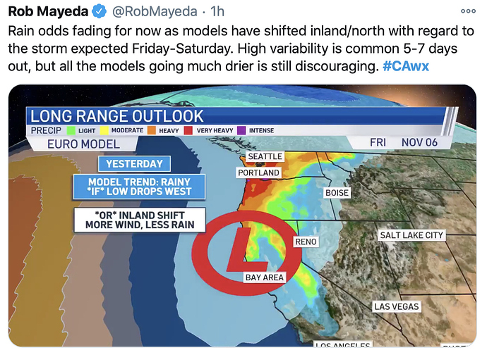
NWS SF Sunday: Yesterdays runs had a more westward track over the waters Friday and Saturday leading to better chances for precip. Todays runs are shifting a little more eastward (almost an inside slider vibe), which would be drier. As noted before, the flip flop runs on deterministic models is not that unusual so it`s wise to look at ensembles. Unfortunately, this round of ensemble guidance is also trending drier. Further digging into ensemble via WPC Cluster models (technique to pull out ensemble uncertainty/where members place) is showing more clusters leaning drier with a higher member count on the drier side. Therefore, updated longer range forecast downplaying rain chances Friday and into the weekend. As of now the forecast will reflect more of a scenario with 15-20 pct chc of precip with scattered showers. One part of the forecast that has remained consistent is the temp drop from Thursday into Friday. A solid 10-15 degree drop in temperatures is still likely. Longer range models do show additional rain chances possible next week.
GFS is showing the promise of some showers for the valley and and maybe some wetting rain for the foothills and coast range…
It also still wants to bring a sharp pressure gradient on or about 11/8. There does seem to be support for a possible Santa Ana as well.
Temps should cool down, perhaps enough to bring some snow flurries into the upper foothills.
We will see…
I would say more of a chance for north winds, the east component maybe lacking. PDS has highlighted strong winds for SB and Kern Counties…
Still not a fan of a wind event on Nov 8th… Deja Vu all over again… But Maybe a little moisture first could be a help…
A weak system will allow for onshore flow to return on Tuesday, bringing some minor cooling at the coast; temperatures there will still be above normal but not as warm as yesterday and today, while temperatures across the interior . Little day to day change is expected through Thursday, with warmth continuing before a stronger storm system moves into the NorCal area. Thursday night into Friday a substantial area of low pressure is expected to drop down from the Gulf of Alaska and take aim at northern California. This will result in a big drop in temperatures, and the potential for showers returning to the region. Valley temperatures will dip into the upper 50’s to lower 60’s from Friday through the weekend, while mountain and foothill areas mostly end up in the 40’s to lower 50’s during this time. Showers will be possible on Friday, Saturday, and Sunday. The current model outlook has the best chance for showers on Friday and Sunday. Most of the wet weather will end up in the foothills and mountains, but there is also potential for at least some light showers in the valley. We’ll also have a decent chance for snow in higher elevations,
For the first time in its history (dating back to the 1920-1921 water year) the Northern Sierra 8 Station Index has recorded 0.00” of rain for the month of October.
You can graph different water years at this State site to see how they compare
Good afternoon. The GEFS ensemble mean shows a wicked inside slider moving into the Great Basin on 10/7, with a shortwave rotating around the big trough axis slamming into the Sierra Nevada. The western portion of the trough is over Northern CA… however PWAT are extremely low due to the extreme cold nature of this storm.
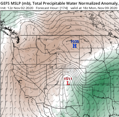
The EPS (Euro ensembles) are slightly further west and wetter, but trending towards more of a dry solution ever so slightly.
The NAVGEM is the driest with almost no precipitation… and has a very clear offshore wind signal, it has been reliable for offshore wind events this season.
A feature that almost all models are missing is Hurricane Eta and this trough evolution will be influenced greatly by where Hurricane Eta is, how strong it is, and how it’s subsequent anticyclone influences the upper level pattern.
So far only the old GFS has it initialized where it probably will be during that time period.
The models all missed Eta becoming a category 4 hurricane today and this changes things as it will likely track north over the next few days.
And a Fine good afternoon to you @anvilhead . None of your graphics look promising for good weather (rain) this weekend. The old GFS with the jet stream running so far south looks particularly troubling . Just more of the same only colder… the tease of rain and the promise of another wind event. Am I looking at these right? 
Like I said… it really depends on what happens with ETA downstream as it moves into the Gulf. If I am a betting entity I say a strong offshore wind event with snow on the eastern side of the mountains and possibly spillover into the west side of the mountains. The GFS also drags another potent shortwave across the Great Basin on 11/12. Will see what happens but being in the medium range of the forecast window there is a 75% chance that precipitation is overdone this early into the season for this type of setup.
Looks like a potential re-load… somewhat of a bad scenario… Much like Camp and Thomas where the pattern remains persistent for an extended period of time…
Not really looking forward to a reload of anything. This Fire season has already had its share of bad scenarios, crazy winds and fires that have consumed everything in their path. I think I am ready for a change of season and a change of what has become the new normal . Tho I think there is a lot of maybe to much measurable rain coming with the front moving thru you can always hope for the best . A system moves in Thursday night into Friday. This front will bring the chance for some rain and high elevation snowfall to the North Coast and the higher terrain of the Shasta/Trinities and the Sierra Nevada. A few showers may also cross the lower elevations of the Sacramento Valley and perhaps the Bay Area, however significant precipitation is not expected for these areas. A weaker trailing system may bring some reinforcing light rain to the North and down the Sierra on Saturday night into Sunday, while the lower elevations likely stay dry. Snow levels will dip down to around 3000’ on Friday. High temperatures will top out in the upper 50’s to low 60’s in the valley on Friday, while mountain and foothill areas end up in the mid 40’s to lower 50’s on Friday afternoon. A lull in the showers is expected on Saturday, Another round of rain and snow showers will track through our region on Sunday, and snow levels could dip to as low as 2500’. Rain and snow totals look lower on Sunday, We’ll start to see north winds picking up late Sunday into early Monday, and dry weather will return for the start of next week. We’ll continue to have below average temperatures through at least Monday, but we’ll more than likely stay cool through the middle of next week. Another wet system will also be possible for the middle of next week. Still a day or two away from the crystal ball seeing this clearly as has already been noted previous posts. Hopefully we stay away from extended patterns of wind ,drops in the jet stream to Mexico… and hurricane Eta … whatever that throws at us. The chance of rain is improving in forecast I have read thru this afternoon versus yesterday.
I would agree, the second front looks more robust than it did 36 hours ago. The wind event looks to be more short lived. I do think the worst impacts maybe in CSR.
Warm frontal boundaries vs sharp cold fronts should be the hope everyone- any sharp boundaries with narrow cold fronts or steep lapse rates with thunderstorms is not what is needed…
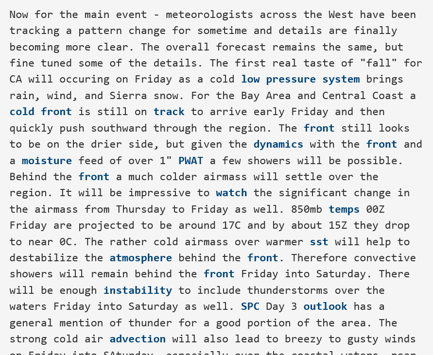
From NWS Bay Area AFD:
It is starting to look really good for precipitation chances, at first I was skeptical
Models have flipped to a more progressive solution, with storms every few days. Big change to the overall pattern, will definitely slow things down in North Ops…
The infamous crystal ball is finally getting a little clearer. Not a real soaker with predicted totals around a half inch ,but it may be a beginning of a couple of fronts and more seasonable weather. Low pressure dropping down from the Gulf of Alaska will start in northern California late tonight and will spread showers across NorCal by early to mid day on Friday. Bringing the first precipitation of the water year to many. The most significant rainfall will come to the North Coast, Shasta/Trinities and the Sierra Nevada, with more scattered shower activity for the Sacramento Valley and Bay Area. This system will shift southward on Saturday, bringing showers to the Central Coast, San Joaquin Valley and the Tehachapi mountains. Along with the rainfall, the system might also bring high to mid elevation snowfall. A period of breezy north to northeasterly winds is then expected on Monday. The pattern may become unsettled again early next week with a cold front dropping into the territory, potentially allowing for scattered showers across the North. Overnight low temperatures won’t change much, but a cold front moving through will result in a substantial drop in high temperatures. A Winter Storm Watch has been issued for areas above 5000’ in Shasta, Lassen, Tehama, Plumas, and Butte Counties from Friday morning through 5pm Sunday for the potential for moderate to heavy snowfall. Snow levels will be down to as low as 4000’ on Friday. We’ll also have a Winter Weather Advisory in effect for northern Trinity County from 10am through 10pm on Friday. 3 to 6 inches of snow will be possible in areas above 5000’ from Friday morning through Saturday afternoon. We’ll also have a moderate threat of thunderstorms in lower elevations on Friday.
A second wet system will bring more rain and snow showers to the area on Sunday, and models are showing this second round of rain and snow could be heavier than the first. Snow levels will be down to around 2500’ on Sunday. Showers will mostly wrap up late Sunday evening,we’ll have another chance for showers returning for the middle of next week. Finally some weather to look forward to! Maybe enough to send some firefighters home at last.
Evening Update
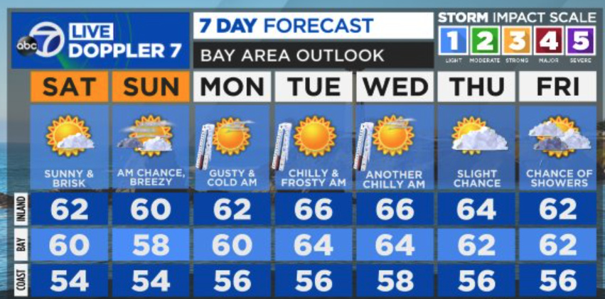
It is beginning to look a little hit and miss for our weather weekend. The is not going to be a big rain maker for most of us . Mostly on the coast line and up in the sierra’s and not so much in the Valley area. Mostly scattered showers with the possibility of thunderstorms. The only thing that seems for certain is it will be colder and a bit breezy… with little precip. Forecasts changed from up to .25 to less than .10 tonight Tho some models show a possibly wet pattern developing in a week or so…
NWS SF Saturday: In a somewhat odd setup we will need to watch for some possible fire weather concerns as gusty north/northeast winds will develop Sunday night as an offshore pressure gradient sets up as the trough ejects eastward. Worth noting that for places that receive no rainfall this weekend that fuels remain at record dry levels.
No rest for the weary I guess. Sort of a disappointing day yesterday as we received very little to no rain in these parts . It was cooler with a little breeze but not many clouds and this morning is scattered clouds. The snow in the mountains looks a little sparse when I look thru the cameras of the Northern Sierra and Lake Tahoe . Just not the day we were hoping for.
Tonight, the next wave will move over Nor Cal which means another round of rain and snow showers. This is expected to be more potent than the first wave, which will bring heavier bouts of snow Saturday night into Sunday morning. A Winter Storm Warning remains in effect from late Saturday afternoon through Sunday afternoon for higher elevations of the Sierra Nevada and mountains of Western Plumas County above 4,000 feet. Total snow accumulations of 6 to 12 inches are expected, locally higher. Breezy north to east winds also return to the region Sunday into Monday as the low gradually exits the region. Gusts in the 15 to 35 mph range are possible. Relative humidity will be lowering as well, but generally stay above 25 percent. We have a 20 percent chance of showers with predicted total of less than .10 of an inch. The fuels here are brittle they are so dry… With no PSPS called for Sunday nights winds you have to cross your fingers and hope for the best

