I think it was pretty spot on. Here at my house we received a trace of rain and snow just below 4000FT(Twain Harte). Ground was wet but drip line under trees stayed dry. Now I have a 10 to 15 mph w/gust to 20mph wind blowing out of the east. Mount Elizabeth in the last 2 hours wind 25 gust to 42. Thats at 4942FT a mile or two from the house. I for one wouldn’t want to be chasing Debris Burn escapes tonight…It’s freaking cold and windy out.
2 Likes
Forecast & Warnings
https://www.weather.gov/wwamap/wwatxtget.php?cwa=sto&wwa=all
National Forecast Map
2 Likes
Ya, it might change the burning characteristics of the 1 hour fuel by a whole 15 min
2 Likes
http://ferix.water.ca.gov/webapp/precipitation/
Give this tool a try does not look good
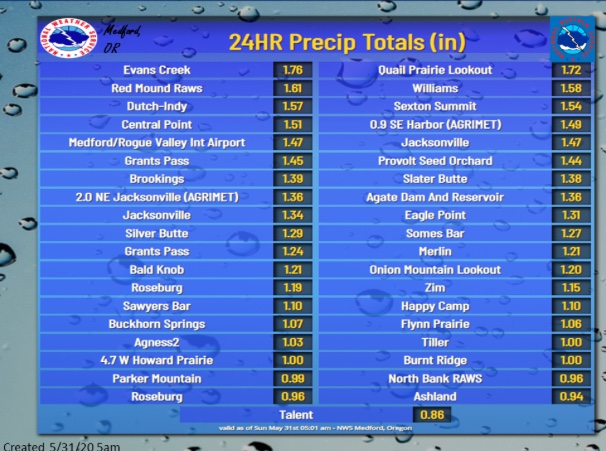
Just to put things into prospective, yesterday helped a friend burn 28 piles. 20 were made last weekend with a excavator and 8 yesterday. Live oak and Manzanita. Did 20 pile with just two dip torches and these are good size pile on 30 acres. Most of the piles complete consumption of fuels. Manzanita was starting to flower. Most of the fuel size was 10 to 100 hour with some piles had 1000. Fuels were way to receptive for this time of year. Stays like this with very little precipitation in the near future, going to be a long Summer and Fall for the crews. Elevation was 2500 ft Sonora area on south facing slope. . At Twain Harte in my rain gauge yesterday .15…Where we were burning just enough rain to keep the fine fuels(ground litter) from skunking around. .
6 Likes
Current Forecast
Warnings & Watches:
https://www.weather.gov/wwamap/wwatxtget.php?cwa=sto&wwa=all
National Forecast Map
4 Likes
It’s needed!
1 Like
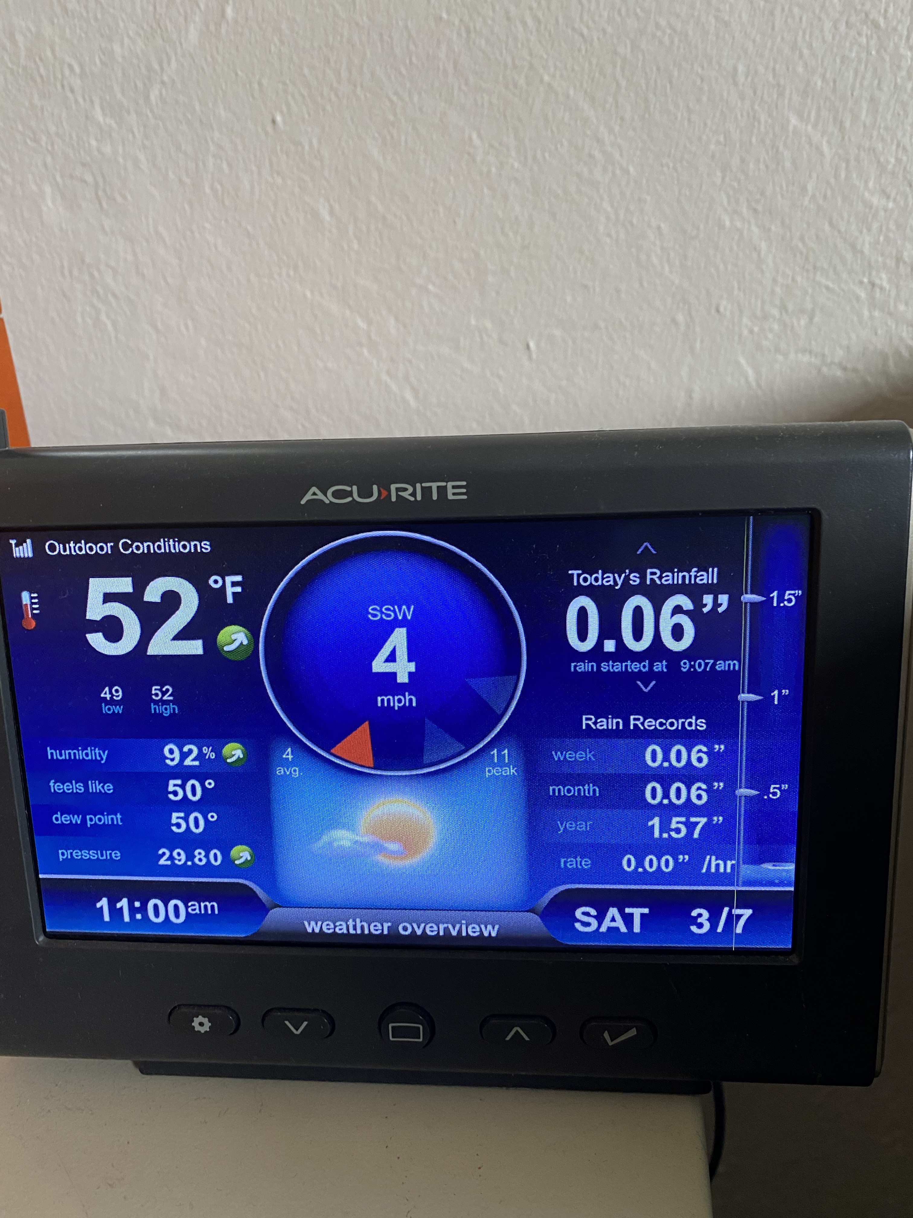
So far at 3800’ 5 inches of rain in the gauge from this storm. Spitting snow now and then but not sticking. Raining hard and steady as I’m typing. Looks like for the time-being we lucked out.
3 Likes
Forecast Outlook
Weather Advisories
https://www.weather.gov/wwamap/wwatxtget.php?cwa=sto&wwa=all
National Forecast Map
1 Like
North Ops Seasonal Assessment Video:
1 Like
Regional Forecast
Weather Outlook

Fire Weather Forecast
https://www.wrh.noaa.gov/fire2/?wfo= sto
National Forecast Map

1 Like
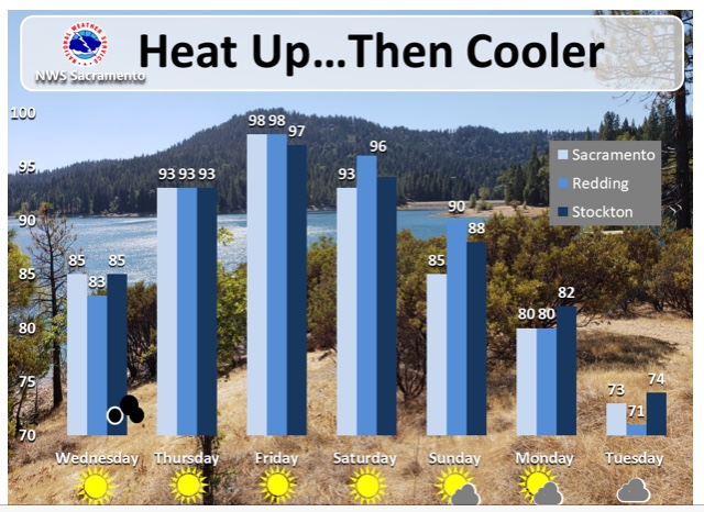
Looking like a good NOPS heating trend coming up this week!
Regional Forecast
Precipitation Totals
GOES West Imagery
https://www.star.nesdis.noaa.gov/goes/sector_band.php?sat=G17§or=wus&band=AirMass&length=12
National Forecast Map
1 Like
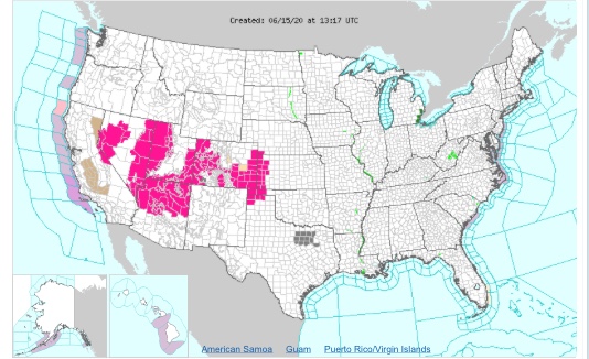
Red flag through Saturday for some of the sierras https://www.weather.gov/rev/
1 Like
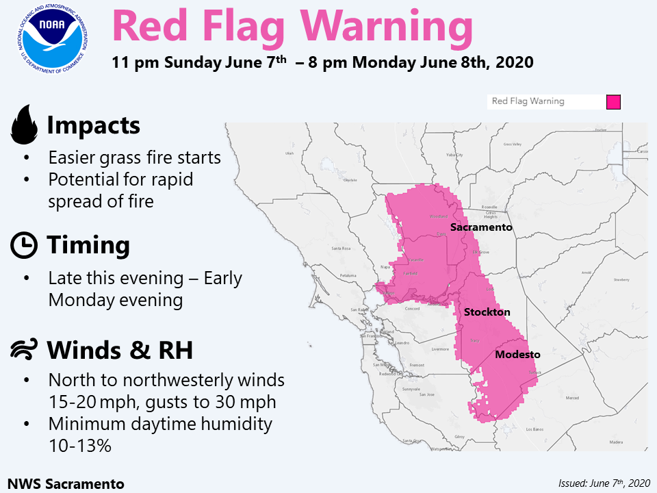
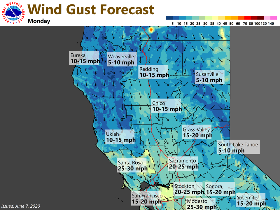
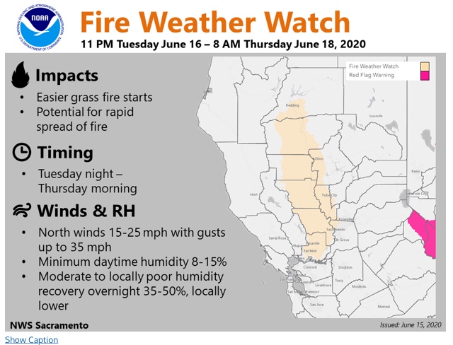
RED FLAG WARNING IN EFFECT FROM 11 PM THIS EVENING TO 8 PM PDT MONDAY FOR LOW HUMIDITY AND BREEZY NORTHERLY WINDS
Red Flag Warning issued June 7 at 9:54AM PDT until June 8 at 8:00PM PDT by NWS Sacramento CA
…RED FLAG WARNING IN EFFECT FROM LATE TONIGHT THROUGH MONDAY
EVENING…
.An upper trough passing to the east will bring a period of breezy
northerly winds to the region tonight into Monday. These dry winds
will lower daytime humidities into the 10 to 13 percent in many
areas accompanied by moderate to locally poor overnight
recoveries. A number of grass fires have already started, while a
larger wildfire is currently impacting Solano County. Elevated
fire weather concerns exist across the Red Flag Warning area. This
includes western portions of the northern San Joaquin and
southern Sacramento Valleys, as well as the Delta region through
Monday evening.
The National Weather Service in Sacramento has issued a Red Flag
Warning, which is in effect from 11 PM this evening to 8 PM PDT
Monday.
-
AFFECTED AREA…Fire weather zones 217, 218, and 219. The
northern San Joaquin and southern Sacramento Valley, as well as
the western side of these Valleys into the Delta region. -
WIND…North to northwesterly winds 15 to 20 mph with gusts up
to 30 mph in some locations. -
HUMIDITY…Daytime minimum humidities 10 to 13 percent with
moderate to locally poor overnight recoveries in the 30s to 50
percent. -
HIGHEST THREAT…Near any existing wildfires.
-
IMPACTS…any fires that develop will likely spread rapidly.
Outdoor burning is not recommended.
A Red Flag Warning means that critical fire weather conditions
are either occurring now, or will shortly. A combination of
strong winds, low relative humidity, and warm temperatures can
contribute to extreme fire behavior.
3 Likes
Regional Forecast
GOES West Imagery
https://www.star.nesdis.noaa.gov/goes/sector_band.php?sat=G17§or=wus&band=AirMass&length=12
National Forecast Map
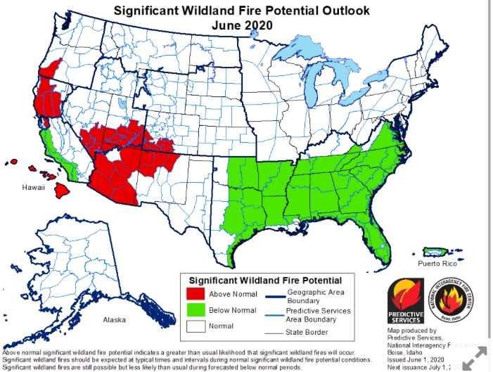
June Outlook
1 Like
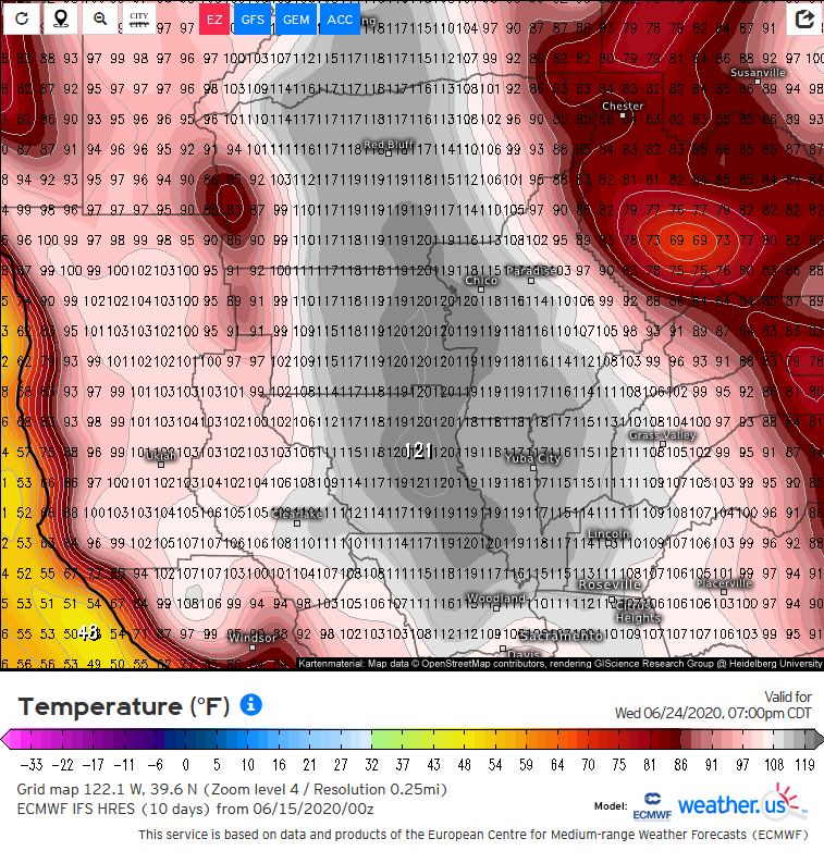
These temperatures will not verify as it’s essentially a 1 in 100,000 chance, but check out this ECMWF output for next week. There is growing model consensus for a prolonged, potentially dangerous heatwave across the San Joaquin Valley next week. I would expect temperatures to be in the 105-112 range at least.
2 Likes
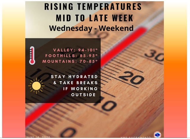
Tomorrow night into Wednesday a Diablo wind event sets up across Northern California. The combination of drought, RH 10-15%, temperatures 85-95 degrees, and N winds of 15-20 mph will likely create critical fire weather conditions for several hours in terrain favored areas. After which, ECMWF continues to indicate a prolonged heatwave as weak surface high pressure builds into the Great Basin and a ridge of high pressure builds overhead. The European model output is much warmer than the GFS, temperatures would be about 10-20 degrees above normal through Tuesday of next week. The GFS would be about 5-10 degrees above normal.
2 Likes