No adverse weather is forecasted for the Labor Day weekend and extended forecast period (thru Sept 7th). Temperatures will be monitored in the Bay Area for stress on the electrical grid, but nothing on the horizon for fire weather.
Middle to the end of next week in the models right now shows a mult-day run of temps over 100 in the valley and single digit RH’s. If the thermal low develops with single digit RH we could see a period of winds similar to the start of the Park fire.
5 Likes
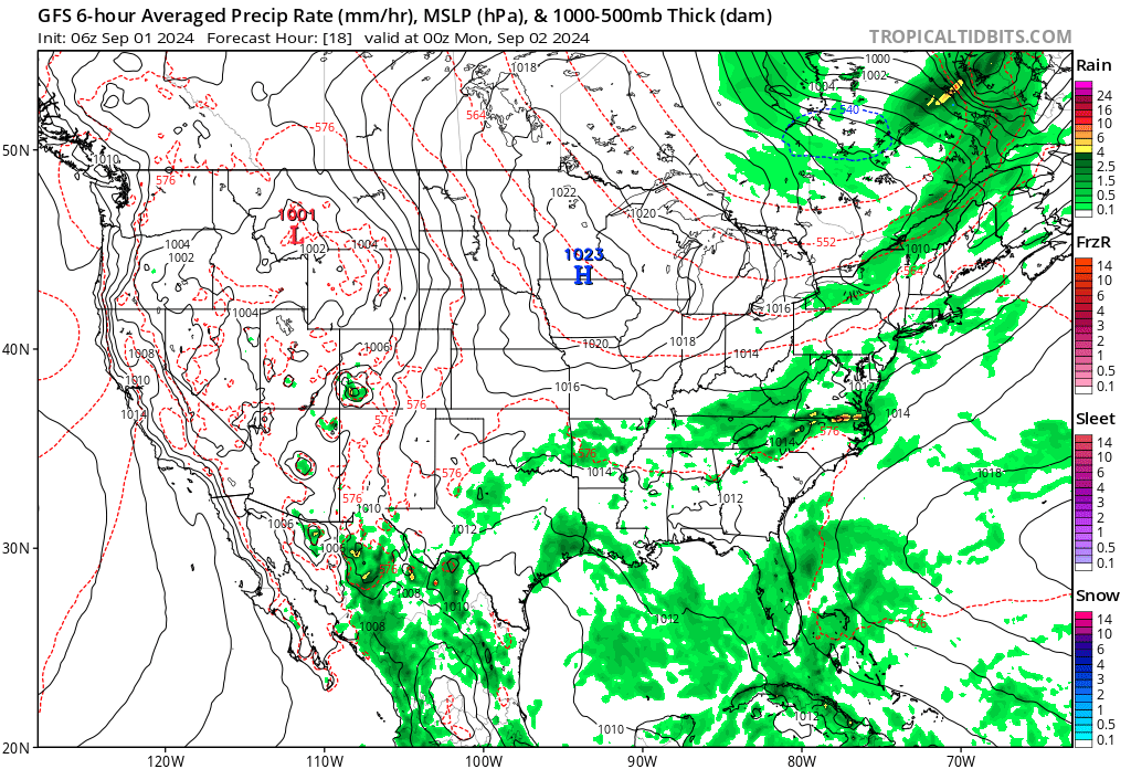
A weak low-pressure system is forecast to move through the territory Sunday and Labor Day with temperatures across the far interior decreasing back to near or slightly above average and into the 90s. Coastal areas and valleys should also be slightly cooler and mostly seasonable. That low pressure system may also produce scattered showers and very isolated thunderstorms over the Sierra and northern mountains Saturday and Sunday, generally away from assets. High pressure will then rebuild next week resulting in fair and warmer weather, including hot temperatures across the interior. Isolated afternoon showers and thunderstorms will also be possible again over the high Sierra by mid-week. Cooler weather is favored to return to the territory by the end of next week for the coastal and Bay regions and across the interior over the following weekend. No adverse weather is currently forecast for the Labor Day weekend and extended forecast period
4 Likes
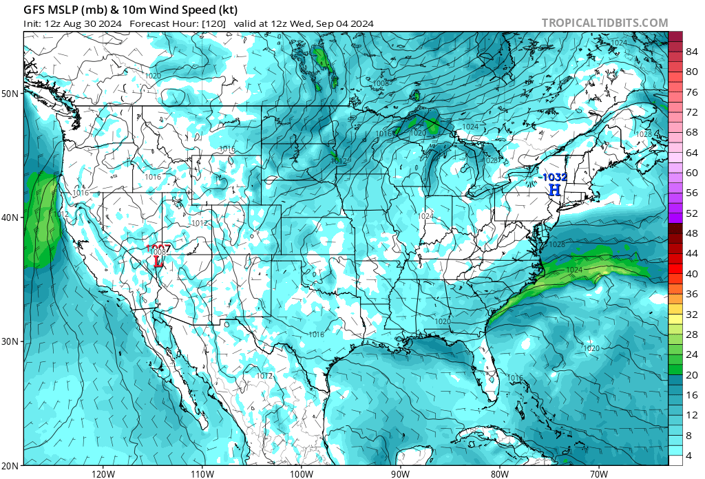
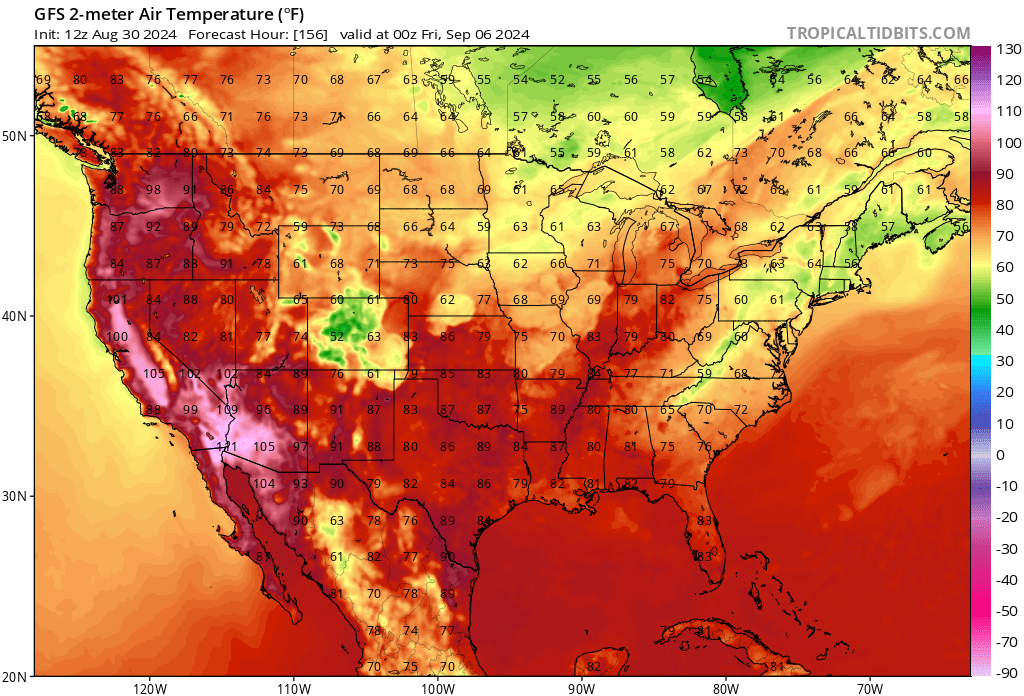
I would point out that the trough passage will bring about an offshore wind pattern that will focus the low end winds on the usual spots in NOPS. That gradient will enhance down canyon winds in the typical spots. The large scale result will be warming and drying across the region. By Wednesday temps in the valley will be above normal and remain there through the end of the week. RH will approach single digits at times. The models diverge at the end of the week with regard to the strength of the next trough, the Euro brings about more robust cooling while the GFS remains warmer with a second heat wave to follow. The ensembles( blend) tend to be more along climatology with a middle of the road approach.
What does stick out is the changing patterns. Saturday-Monday will feature some very strong winds and a Haines of 6 in the NW mountains and that has been highlighted for the Shasta Valley and areas of the Modoc. The temps there are above normal now and will remain there through Saturday mitigating any effects from the recent rain. There are slight chances of lightning from some convection but most of that seems to be confined to areas east of the Cascades.
As the trough moves inland it does appear that some strong on shore flow will accompany it as would be expected. That transition is where the adverse weather will appear. Hot temps this week, strong winds over the weekend into Monday and then a transition back to offshore flow and hot temps again by early next week. Add in the holiday effect…
If you really want to dig into the details… a thermal trough looks to establish by Wednesday. This sinking air will enhance some downslope winds at night and can cause a very dry slot of air above the inversion to reach ground level. These scenarios help to bring about the “second” burn period which occurs overnight. This has had serious impacts on existing fires.
The thermal trough can enhance downslope winds at night and in am, only to have the normal dirunal winds arrive by mid afternoon. These are not uncommon or a situation that shouts watch out… unless you have an established fire.
As for the end of the week… kind of muddy right now, but it does look like another transition to a cool down… more wind.
I would also state… I am not an IMET… my information is derived from NWS Medford, Sacramento, and Monterey AFD’s and the weather discussion from PDS. Attached are two graphics, one of the wind direction( 850 mb charts) and offshore gradients mid week and the other of the temps. If you would like I can add the RH and graphics showing the formation of a thermal trough.
9 Likes
So why did the NWS issue a Fire Weather Watch???
1 Like
I suspect your information is coming from a utility based perspective, that observation is based on the word"assets".
There is a contrast between threat to infrastructure and critical fire weather. Not all critical weather patterns are a direct threat to infrastructure until a fire begins.
I am not sure this event will rise to a FWW but if the RH and temps last long enough it might. If it did not, it would be based on duration of event( a limiting factor).
Looking at all the models it does appear that some periods of enhanced fire weather will be present across NOPS this week. While it might not rise to a watch or warning level… it should be noted. Not sure I would go out on a limb and state that any product is better than the NWS… they are and should be the default voice on fire weather products. They spend a lot of time working with local FBANS and PDS in the respective regions when they issue a fire weather product.
10 Likes
Norcal, thank you for a very informative and detailed explanation of our wx in NOPS. For a guy who isn’t an IMET, you are pretty spot on. Sometimes the wx explanations can get pretty deep. Thanks for bringing it down to a level the typical fire service professional can understand. From my 2 cents, I think your posts do address the topic of this fire wx thread…
10 Likes
It’s a very positive thing that we still have power. Most people’s electricity bills are between $500-$1,000 dollars last billing cycle and the state is about to dish out $500 million in refunds… So my intuition is very much correct. Irregardless of causality/policy causing the high bills, the long duration and high levels of heat have made individual households and businesses electric bills almost unaffordable to the point of bankruptcy. We need to continue to manifest positive outcomes rather than doom.
10 Likes
I’m fairly certain it’s still summer and we’ll see a few more warm/hot days yet with with some ‘fire weather’. Won’t be long and Fall will settle in followed by cold rain and snow… Then come Spring/early summer we’ll start it all over again. It’s been that way for a ‘few’ hundred years now… Easy guys 

9 Likes
Because there’s going to be wind 15-25 mph in northeast Cali and northwest Nevada for a duration of 3-6 hrs on Monday.
https://forecast.weather.gov/showsigwx.php?warnzone=CAZ071&warncounty=CAC035&firewxzone=CAZ278&local_place1=15%20Miles%20E%20Eagle%20Lake%20CA&product1=Fire+Weather+Watch&lat=40.6184&lon=-120.4559
1 Like

Funny how it happens year after year with a cycle. It always cracks me up how we report it likes it’s groundbreaking that we hit 100+ in the summer and it gets really windy in the fall. Then we have this deluge of water that ends it all.
16 Likes
2 Likes
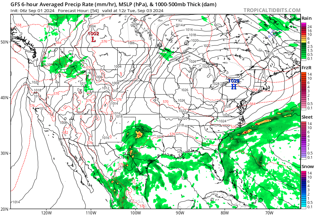
Forecast looks to remain on track for the early and mid week period. Cool down across NOPS today to average and below average temps. The area of LP will track north of Ca over Monday. This will take us across NOPS to below normal temps and an increase in RH. Winds crank up though… and will be gusty across the expected areas of the Bay Area, Central Valley and Shasta Valley and Modoc. East side will see some wind as well. That area has the potential for some strong down slope winds.
By Monday night the LP trough swings inland and moves east. This will usher in the first change, weak offshore flow will begin late Monday-Wednesday am. Peak looks to be Tuesday. This weak flow will bring warming temps and lowering RH. Temps bounce to above average for the middle of the week, with temps in the valley over 100 for much of Wed-Friday.
Some low RH will be likely. A thermal trough will establish and keep RH recoveries poor at night and overnight minimums in the Foothills will be on the mild side.
One new wrinkle in the models appeared this am… possible convective activity by the end of the week. This is shown on a couple of models… but I would still consider it fantasy land but more on the legit side of fantasy land.
As one of the IMET’s I respect always says in am briefings… “In fire weather it is the Delta( change) that we look for”.
This week and Fall in general is about the Delta. A lot of changing conditions through the next 7 days.
Yup… weather happens every day, every week and every year. The Chinese warrior Sun Tzu said famously…" if you know yourself and you know your enemy in 100 battle’s you will be victorious 100 times". The advances in meteorology allow us to cheat…we get to predict what type of fight we will be in.
Attached… 3 graphics. First gradients showing 4-6 mb onshore flow on Monday, then the reverse flow to offshore by Tuesday/Wednesday.
Last… sounding for some moisture by Friday. This shows the spread between the DP and temp. This is a single sounding but shows an inverted V profile which would indicate storms could be on the drier side. Steering level winds look to be moderate which could indicate faster storm motions. I would keep that in the "fantasy land " category. Perhaps someone with more formal education than I have can weigh in on that period.

14 Likes
Coming back from Wyoming last night about the Bear River Reservoir road on HWY 88 it was 67 Degrees at 0100. That’s around 6000 FT.
6 Likes
Fire season is still on for NOPS. Here’s the predictive services fresh seasonal outlook:
5 Likes
3 Likes
3 Likes
4 Likes