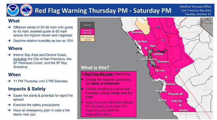
Watches have been upgraded to Red Flag Warnings:
https://forecast.weather.gov/product.php?site=mtr&issuedby=MTR&product=RFW
I wish they gave elevation estimates, I know sometimes they isolate to “above 1500 feet” sometimes though we get zero wind on the valley floor during red flags
The warning says including San Francisco, so a safe assumption will be NE winds at the surface at least on the coast.
A post was merged into an existing topic: California Fire News & Weather
@FireGuy1985
You promised this wouldn’t happen!
https://www.youtube.com/live/T0DRb8SlW6E?si=Q-_TRsvIKhtBcKV1
Daniel Swain is Live stream now discussing this wind event
Everything got real wet here the last couple days on the east side of the valley. What happened in the red flag areas?
What? The end of fire season?!?!
It’s over bud just accept it.
Just stand-by…the south will rise again. Maybe even one more part way up toward the north.
Snow above 7500ft in the tahoe basin and down to 6000ft in Western nevada with red flag warnings for bay area. 
It was spitting snow this afternoon between Susanville and Lassen Park in 44 as I came through.
Not sure.20 inches is real wet. A wetting rain must be .10 so, 2/10s is not enough to change anything. By Friday am it will be as if it did not happen.
No. Just the wind event and critical fire weather you said we weren’t going to have. Because your data is better than NASA.
It was a joke. You don’t have to get chipped and have an attitude.
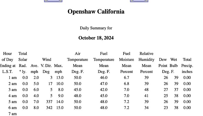
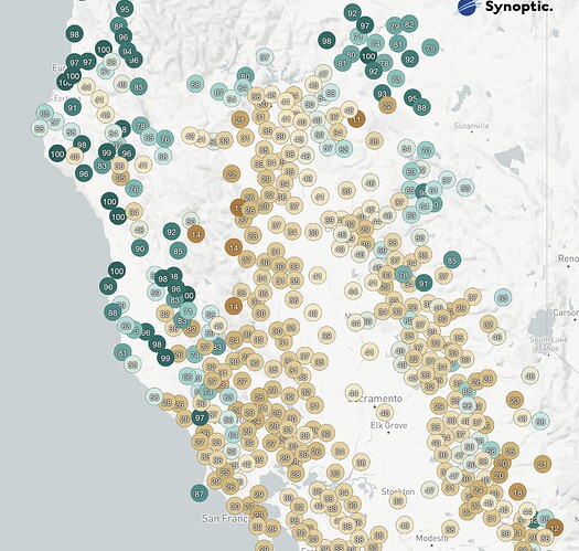
Dead calm in Chico this morning, and it looks like humidities haven’t cratered, yet, though they are low west of I-5 and North Bay.
Openshaw RAWS is on Valley floor between Chico and Oroville.
RH map is from 0600 today.
I am in Santa Cruz County between Santa Cruz and Felton. Sustained wind of roughly 5 mph with occasional gusts to roughly 30.
https://www.wrh.noaa.gov/map/?obs=true&wfo=sto
You can watch the winds move across the valley from west to east. The cold air will allow for stronger winds to develop in the larger drainages. The coastal mountains have already seen some really strong winds.
How does the cold air support stronger winds in the drainages? Is it because we aren’t going to get diurnal winds due to lack of heating in the mountains?
The colder air is denser, falls faster and in effect disrupts the normal diurnal flow and rising air from slope heating.
As the jet stream moves to the south the patterns change and we see more cold air influenced subsidence. This is a more “easterly” based event driven by the Low moving down the GB towards the 4 corners.
In the summer months May-September we typically see more H pressure dominated events, tend to have more north wind and less east winds. The colder based events are more efficient at moving air down into the valley and sustaining it overnight.
This is the reason the 2008 Camp Creek Fire did not jump the WB and go into Paradise.
The air funneled down drainage along the WB, as opposed to the 2018 Camp Fire( similar pattern to the current one… but much stronger) the easterly winds pushed out after day break and only briefly subsided before increasing again after the sun went down.
This cold air will begin to pool up in the GB and set the stage for SOPS to get its first real SA at some point.
Simply put, the cold heavier air is good at finding the quickest way to lower ground.
Zero wind in Forest Ranch or Magalia right now.


