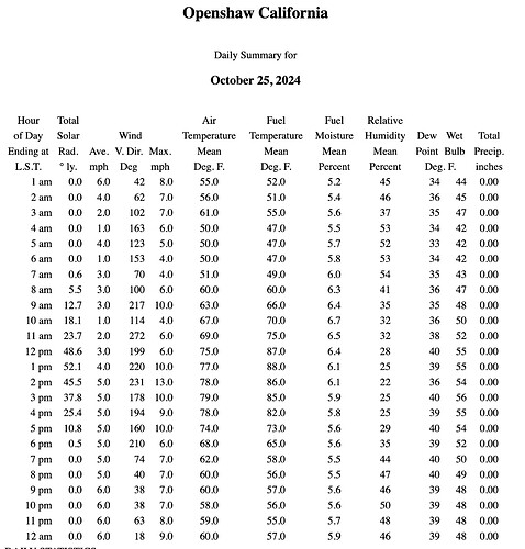
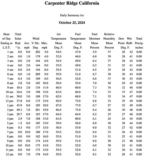
Woke up at 01:36 to wind strong enough to rattle doors and a temp of 76 with a humidity of 13%. At 06:15 it had cooled down to 64 with a humidity of 26%. This is in Sonoma where I’ve been wearing a jacket or vest in the morning for the last week. The temps seem to be about 10 degrees above what was forecast. The warm winds this morning very much remind me of the morning that the East Bay Hills fire took off back in the early 90s.
Which started 33 years ago today
Far North and the coast Mendo North, but that’s about it.
The season has felt over in Butte County for awhile now. RH and temp in the hills are into rx-prescription weather, no big fires for most of NorCal since the Park Fire, and we’re supposed to get a cool down and showers through the week.
Bay Area has had hardly any rain but the temps are dropping, lows in the 30’s next week, still potential but low probability for anything
Just a light sprinkle in el dorado county.
Fall weather on tap for the next week. Whiplash would be the best descriptor… Small but significant from a precipitation perspective is on tap for late tonight through Saturday pm. Significant from the perspective that the precip while modest , totals have been trimmed back, but it will blunt two periods of offshore flow.
The first will arrive Sunday and be moderate, typical places will see winds in the 25-30 mph range( west side of the valley and Delta). East-West canyons will also see some gusty winds.
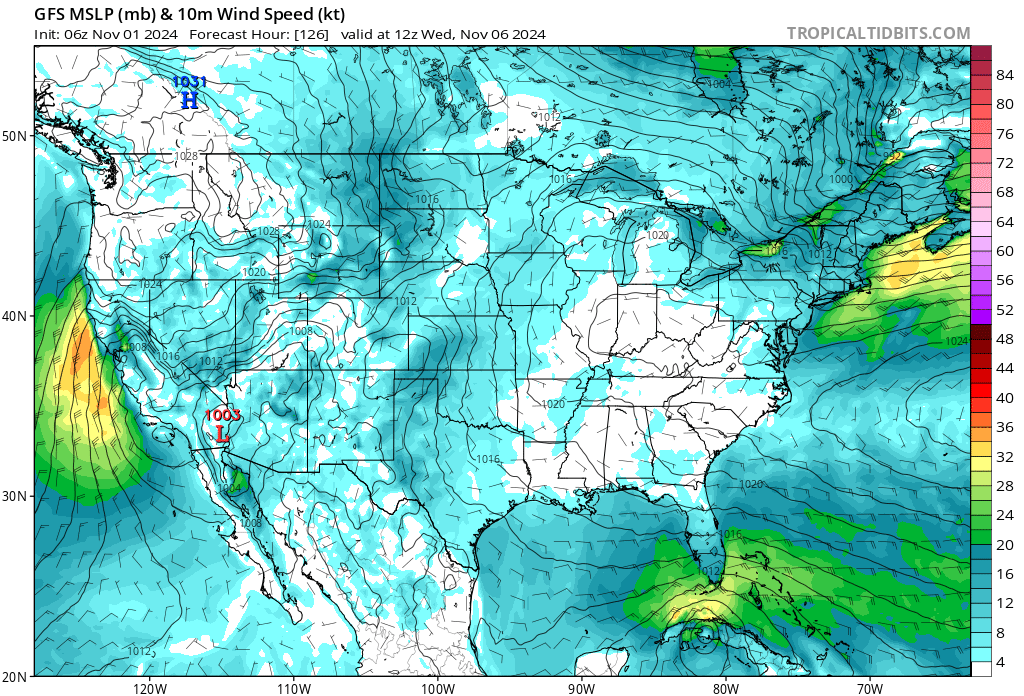
Tuesday another trough will brush past the state to the north. This trough will be mostly dry for areas south of Redding( for now). Once it swings through a sharp gradient will build in with a a period of 48-60 hours of strong offshore winds. On Wednesday these winds could reach advisory levels in the Delta and west side of the valley. Sac AFD mentions possible fire weather concerns with the event.
While the wetting rain will help reduce the IC it will only take the edge off the BI. The live fuels are at their driest and the dead’s will respond to the desiccating wind and low RH.
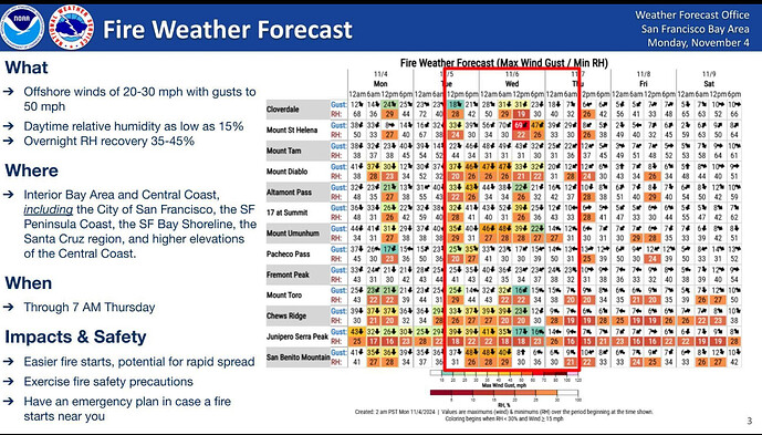
Looking at the models… I would not be surprised to see a FWW or RFW issued for a greater area in NOPS. Possibly expanding to areas of the Sac Valley and Foothills. Strikingly similar set up to events in the past which had serious outcomes. Concurrent SA event with Jarbo and Diablo wind events. Right now the bullseye of strongest winds appears to the be in the North Bay hills and Delta but all areas in the Sac Valley will see a 48-60 hour period of offshore winds and low RH and a 24-36 hour period of possibly advisory level winds. RH’s in the coastal areas are running at 30% already this am and the peak drying has yet to arrive.
Peak period will be Tuesday night through Wednesday at noon… will be interesting to watch how it plays out…
https://forecast.weather.gov/wwamap/wwatxtget.php?cwa=STO&wwa=red%20flag%20warning
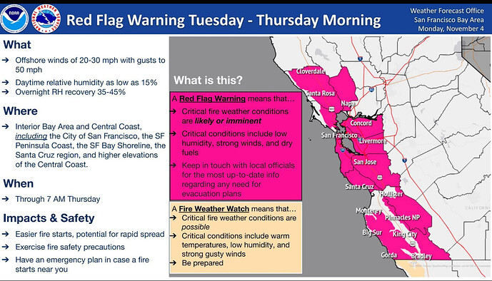
NOPS … now a RFW for much of the valley and lower foothills.
I don’t know how to really phrase this, and I understand the need to inform the public they need to be careful with fire when it is windy, but it seems like RFWs are a pretty blunt tool, and that the NWS often overstates the true hazard.
We know big offshore wind events have brought us our biggest tragedy fires, but the upcoming RFW for the North Bay is coming under dramatically different conditions than say the 2017 Wine Country fires.
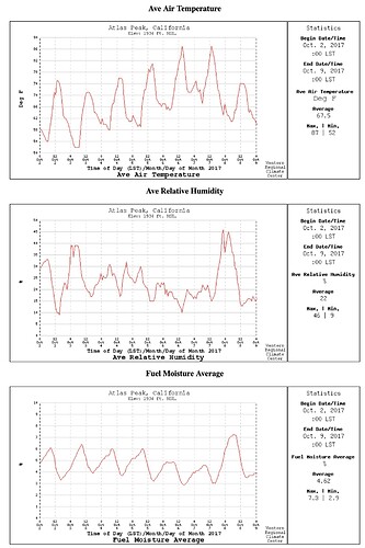
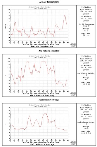
Here are 7-day weather graphs for Atlas Peak for the week preceeding the 2017 Tubbs Fire vs the past week, in 2024:
2017 - Daily temps over 70 degrees, min RHs 10-20%, 10hr FM 3-6%.
2024 - Daily temps below 65 degrees, min RHs 30-70%, 10hr FM 9-24%.
ERCs across NorthOps are average and forecast to bump up to 40% at the peak of this event.
100 and 1,000hr fuels are both above average.
https://gacc.nifc.gov/oncc/fuelsFireDanger_Erc.php
It seems like we could be more precise with our messaging around high-risk conditions - if nothing else, because often in the past, RFWs anywhere in NorthOps have resulted in shutting down prescribed burns region-wide, during our already narrow underburning windows.
Zeke- good feedback and fair assessment. The struggle with how the fuels are different this year makes this event challenging. When looking at the current map of where the Red Flags are I think its about as well coordinated as possible at this time when we have to balance county lines, utility interests, CalFire units, USFS units, topography, climatology, etc. Often times when we try and get surgical a fire outside of the area of the RFW creates confusion or distrust with public and even fire agencies. Quite frankly if this shuts down some Rx burns for 48 hours that may be a good thing so we dont see a repeat of some of the recent escaped Rx fires in New Mexico and elsewhere. Without having the opportunity to dig too deep I will say acecdotally the meteorological setup with this has similarities to the Camp Fire, Kincade, Wine Country (as you noted the Sept drying leading into that after long term drought was different and it was a month earlier). Down south the Santa Anas that result could be similar in strength to 2003 and 2007. If no new ignitions occur this event fades to black. If anyone recalls the 2004 Power, Freds and Rumsey fires this event looks similar as well. Anyway, at the end of the day the utility mets, gacc mets and NWS mets are all seeing the same things and doing their best to coordinate. The forecast BI for the Bay Area hills is the second strongest of the season with the other one associated with the trough/wind event that occurred when the Park Fire first went bananas. https://services3.arcgis.com/T4QMspbfLg3qTGWY/arcgis/rest/services/ONCC_ERC/FeatureServer/1/4/attachments/14
Zeke,
The RFW, in my opinion, has evolved to be a Great tool in informing the public and public officials who are tasked with making decisions based on “the greater good” regarding the increased RISK created by these (and similar) windy conditions.
While this event my be exponentially less severe than the conditions of 2017’s North Bay Fires please remember that even a few “Grass” fires in the populated areas of the North Bay will trigger very disruptive and potentially dangerous evacuations.
(While the cube root of the measure of the tragedy of the 2017 would just be a few homes lost and a few deaths, not even making big news these days, it is still a small tragedy worthy of preemptive measures like a Red Flag Warning and it’s inconvenient fallout)
At the present many people most vulnerable to wildfire, like seniors, the disabled and their caregivers are making ready for potential evacuation. This pleases me as it’s proof the RFW works.
I’m ok with putting off your Rx fire and my burn piles if this keeps North Ops public resources available to keep most and hopefully all fires that do occur over theses next few days in NorCal contained during their Initial Attack.
Zeke,
Staffing isn’t what it was even 5yr, let alone 10yr ago. CF has extended staffing of EU aircraft, as have the Feds. The BDF is 24hr staffed, yet has had 5-10 out of region severity engines on the forest all year since May. NoOps has moved several strike teams of engines and crews south to preposition for this event. Finally, social media( specifically Watch Duty) has provided more SA and almost real time info for the public at large (good or bad) the optics aren’t even close to being able to take advantage of real or perceived burn windows.
And just observation as it may be fairly close to the old wheelhouse, there’s going to be 48 to 72 hours of Ideal burn window directly behind the rfw with both a northern and southern flow depending on your prescription. I’d say you’re more likely to have to compete and beg with your AQMD… and I’d far rather be doing that than begging for forgiveness from the public due to four optics. It’s a micro perception not a global intent!
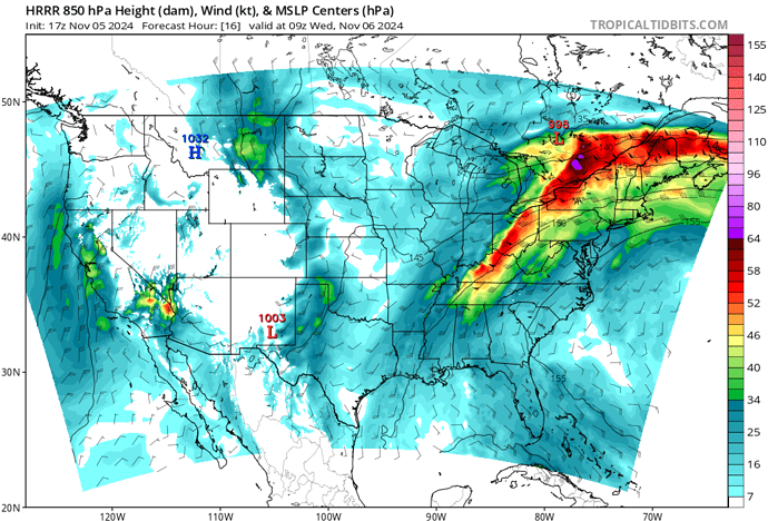
HRRR showing a burst of strong winds for both the North Bay and the Sierra Nevada Foothills tonight for about 4-6 hours. These could lead to the potential of a “Mountain Wave” forming at the base of some of the steeper slopes. Typical areas for this would be below the Geysers, and potentially some areas around Butte and Yuba County where air is funneled down the larger river canyons and opens up to the valley floor.
With this i’m crawlin out on the limb to declare the Dogday’s of Oct/Nov 2024 have ended. It felt like Autum happend on Thur/Fri/Saturday and yesterday was Fall. This a.m. once the warm front passes its going straight to winter!? #bringit!

