Looking at the Hawkins peak camera activity has been reduced quite a bit and getting blown back into itself at least on that section. It did rain.
4 Likes
Any threat to South Lake Tahoe? We have a vacation home up there.
No no threat to South lake at all
1 Like
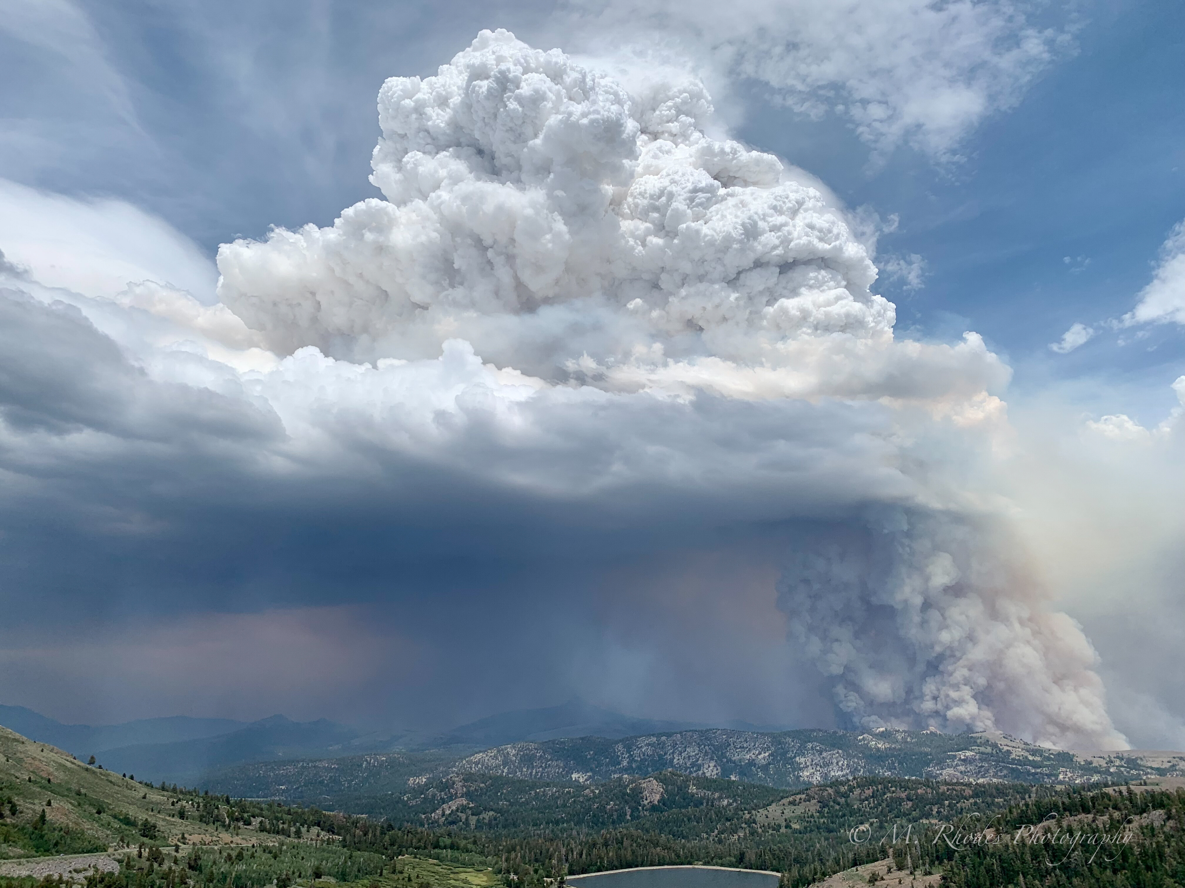
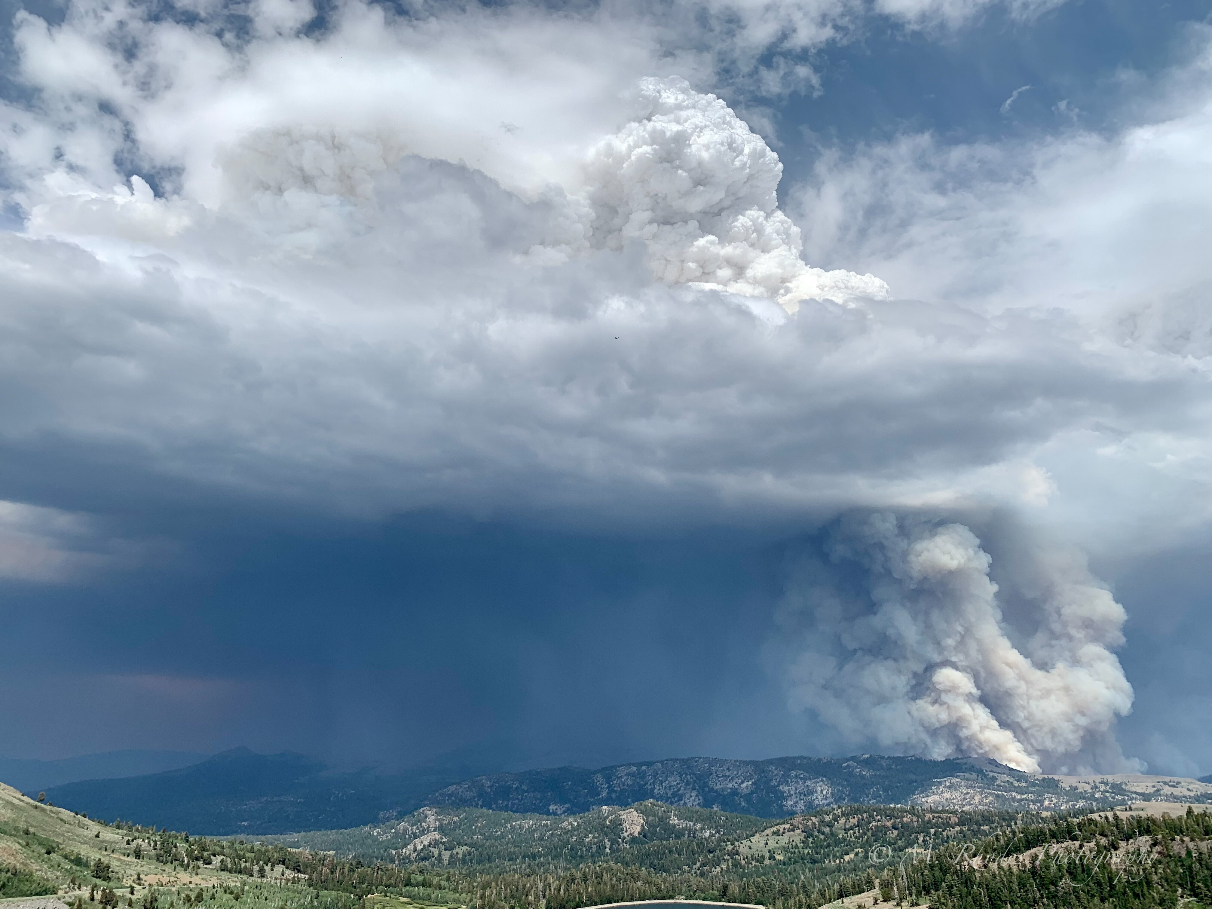
I took these from Carson Pass just as a thunderstorm was developing over the fire. Lots of showers for a bit, but also lots of lightning.
33 Likes

Must have been! I stayed a got a bunch until the column collapsed and smoke obscured everything.
1 Like

Matthew, that is one of the most spectacular photographs I have ever seen. Thank you.
4 Likes
Any meteorological stats on how the elevation of the thunderstorm?
They’ve stopped posting on nifc and switched to new system with user ID and password. Much harder to get info since they did the switch in April.
1 Like
From observing 6 hour play on Hawkins and on Sierra @ Tahoe Cams a cell came over between 1400-1500 with precipitation. Also noted a tanker trail drop in the Hawkins at 13:32 no where close to active fire line. I’m wondering if that is where they want to hold it up and that was prep…or just an accident. Looks like a little convective lift in the column starting now otherwise it’s been a pretty chill day fire behavior wise. Seems like more push to the northeast.
2 Likes
Does anyone have a map with the East Fork overlay in it with Tamarack? I think the Tamarack has already burned up to East Fork (earlier this year) if I’m ready the maps correctly, but if that’s the case there has to re-burn going on. The 2015 Washington Fire seems to be holding up quite well as a natural barrier on the south east side. I was thinking they’d drive indirect from one fire to the other and use it to slow the burn to the east but it looks like it will go into Nevada today with the column forming already. Any feedback would be much appreciated.
1 Like
Couple of updates, it has burned past the East Fork Fire. It is now almost to Highway 395 in the Leviathan Mine area. Evacs being done from the mine area to Holbrook Junction. This is southern Douglas County Nevada. Per AA extreme fire behavior in PJ and sage.
4 Likes

Is it over Bryant Creek?
Yes. As of 3 hours ago it was cresting the north ridge of Nevada Hill, above Double Spring flat.
It has been burning pretty hard ever since.
395 just closed both directions, so it is probably at 395.
https://nvroads.com/
Traffic was flowing in the camera a few minutes ago.
Edit* Now the camera isn’t working. 

395 is basically at the base of Bald Mtn nv.
http://www.alertwildfire.org/blmnv/index.html?camera=Axis-BaldNV&v=fd40729
2 Likes
I am curious about impact to remediation structures/processes at the Leviathan Mine due to the fire. I am not sure just what is in play there now, but curious about possibilities.
1 Like
per scanner traffic, fire has spotted across 395…
1 Like
Its not to the mine area…yet…primarily headed the other way for now