Intel assessment for 8/29. https://youtu.be/46fbppcuwFs?t=749
1 Like
Multiple CA OES strike teams type 3 and 6 deployed today. On the road now.
4 Likes
I heard LNU dispatch for a planned need strike team to meet up at Hwy 20 and 101. Would this be the incident? I was thinking preposition, but this also crossed my mind. I didn’t hear an incident name.
Probably headed North to HUU they have several fires up on the Klamath River Hwy 169
3 Likes
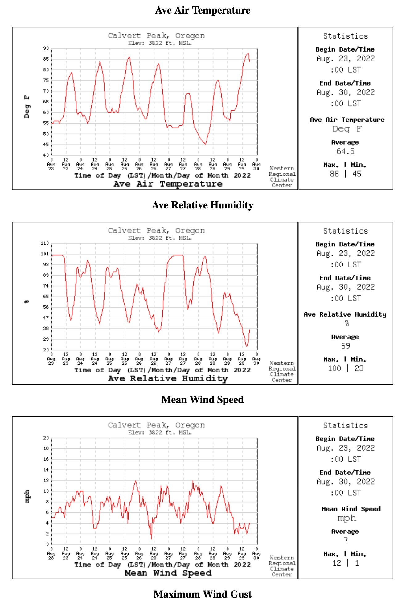
Been watching the weather for this fire. The Calvert Peak weather station shows today is hottest and driest of the week, but winds are the lightest. 8/29/2022.
Anyone got suggestions on better/more representative RAWs for this particular area? This one is 15 miles west, but 3,000 feet higher in elevation. Calvert Peak Oregon
1 Like
Fire growth was limited yesterday due to an inversion layer growth mapped at 986 acres.
Strike teams from EMAC request have begun to arrive today.
Weather forecast 8/30/22
Temp- 90-100
RH- 15-25% with 20-30% in some drainages
Wind- upper slopes and ridges- E 5mph with gust 5-10 in the morning, becoming SW 5-10 late morning, then WNW 10-20mph in afternoon.
Valley/lower slopes- downslope/down valley, easterly 5-10 gust 10-15 in afternoon.
Haines 5.
ERCs 87th-89th percentile
Inversion expected to lift around 1100 which may allow for more fire growth.
1 Like
This one is closer Merlin Seed Orchard Oregon
2 Likes
Where is ICP?
1 Like
In Merlin at the Sprague seed orchard
1 Like
Looks like this week is lining up for something big, Significant fire potential puts a High-risk trigger for ORCA Friday 9/2
3 Likes
1 Like
Is there an IAP link available for this incident?
1 Like
Thank you!
1 Like
Inversion has lifted current conditions are: Temp- 99, RH- 13% Winds - 3-6 gust of 8.
4 Likes
1 Like
1 Like
Fire reported at 14,940 acres with 1% containment.
Today is another day of critical weather- The persistent hot and dry conditions will continue again today with light and variable winds this morning becoming north-northwest this afternoon. The smoke remains a key player in the overall conditions. Clearing smoke this afternoon means more instability will build and critical fire weather conditions can be expected between 1500 - 1900 PDT. Near critical fire weather conditions will remain on Friday as a dry cold front passes the area in the afternoon, bringing gusty NW winds. After the front passes through, temperatures and humidity will moderate Friday night into Saturday morning.
Could be a busy day on the line today
Thursday (0600-1800 PDT}: • WEATHER: Partly sunny due to smoke. Smoke will reduce visibilities the most in the river canyon. •
WIND (20 FT): Upper Slopes/Ridges: SE 2 - 4 mph in the morning, becoming SW 5-8 mph late morning and NNW by early afternoon with peak gusts 14 - 18 mph. (24hr Trend:up 3 -5 mph afternoon) Lower SlopesNalleys: Downslope/valley, generally easterly 3 - 5 mph in the morning becoming upslope/valley 5 -10 mph with gusts 10 - 15 mph in the afternoon. (24hr Trend: Little change) •
MAX TEMPERATURES: 90-95F, except 96 -101 Fat the ICP. (24hr Max Trend: No significant change)
• MIN RH: 13 - 23% (24hr Trend: Down O -5%) •
CHANCE OF WETTING RAIN (> or= to 0.1 O"): 0% •
LAL: 1 •
HAINES: 5 (Moderate) • MIXING HEIGHT: 500ft AGL increasing to 4,000ft AGL late morning, then to 8,000ft AGL afternoon. • MIXING WIND: NNW 10 mph.
1 Like
3 Likes