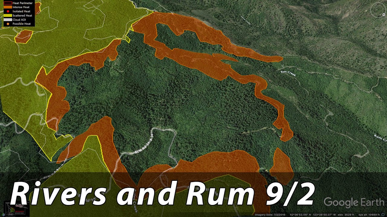
Red flag on the fire tomorrow 11-2300 with a dry cold front moving through.
Our 9/2 Lookout Livestream covers the SRF Lightning Complex and Rum Creek Fire.
SRF is still within control lines, portions of Rum Creek have some potential, still.
Much of Rum Creek hasn’t spread in past 24 hrs.
It seems the next 18 hours will be critical for the fire. Red Flag Warning 1400 to 2100 PDT
Behavior forecast- A rapid increase in fire behavior is expected in the afternoon hours, during the peak burning period associated with a red flag warning and the passage of a dry cold front. The frontal passage is likely to be able to scrub out the lingering smoke cover and expose fuels to the full potential of the weather conditions. Large fire growth with an associated well developed convection column will allow for the most extreme spotting conditions to occur, up to 2 miles. Expect sustained active backing and flanking, with winds shifting from the SE to the NW in the morning and early afternoon hours. Once the system passes, and the air clears, fire behavior will increase very quickly, transitioning from mostly surface fire to crowning fire, especially where terrain, fuel, and wind are in alignment.*
WEATHER DISCUSSION: A dry cold front will move through in mid-afternoon through the evening with gusty northwesterly winds. The dry conditions, combined with the gusty NW winds will produce critical fire weather conditions during the late afternoon and evening. After the cold front moves through, a push of marine air will increase RH values overnight with cooler and more stable conditions expected on Saturday and Sunday …
Friday (0600-1800 PDT): •
WEATHER: Partly sunny due to smoke. Smoke thinning in the afternoon with the passing dry cold front. •
WIND (20 FT): Upper Slopes/Ridges: SE 3-5 mph, becoming SW 5-10 mph around noon, then WNW 8-15 mph in the afternoon into the evening with peak gusts 20-25 mph. (24hr Trend: Up 5-8 mph afternoon)
Lower SlopesNalleys: Downslope/valley, generally easterly 3-5 mph in the morning becoming upslope/valley 5-10 mph in the late morning to early afternoon. Late afternoon and evening WNW 8-12 mph with gusts 17-22 mph (24hr Trend: Up 4-7 mph in the late afternoon) •
MAX TEMPERATURES: 86-91 F, except 91-96F at the ICP. (24hr Max Trend: down 3-5 degrees) •
MIN RH: 13-30% (24hr Trend: Little change) •
CHANCE OF WETTING RAIN (> or= to 0.1 O"): 0% •
LAL: 1 •
HAINES: 5 (Moderate) •
MIXING HEIGHT: 500ft AGL increasing to 4,000ft AGL late morning, then to 8,500ft AGL afternoon. •
MIXING WIND: SE at 5 mph in the morning turning SW 5 mph then WNW 15 mph in the afternoon. Friday Night (1800-0600 PDT): •
WEATHER: Partly cloudy due to a smoke layer and high clouds. Generally smoke is thickest in the river canyon. •
WIND (20 FT): Upper Slopes/Ridges: NW 10-15 mph with gusts 18-23 mph in the evening, becoming NNW overnight 5-8 mph with gusts 10-14 mph.
Lower SlopesNalleys: Upslope/valley 4-8 mph with gusts 9-13 early evening, then downslope/down valley 3-6 mph overnight. •
MIN TEMPERATURES: 54-64°F, warmest at mid-slopes/thermal belt.
• MAX RH: 70-90%, highest on the northern ridges, lowest in the thermal belt. •
CHANCE OF WETTING RAIN (> or= to 0.1 O"): 0%
• LAL: 1 •
MIXING HEIGHT: 6000ft AGL early evening, then falling to 1000ft AGL or less overnight.
One thing they have going for them is that the populated east side of the fire is pretty much sloped out, without a lot of terrain left to climb. Fire is established in Rum Creek on west side, has more potential for slope-driven runs.
Fire size mapped today at 16,940 acres with 12% containment
Thanks for sharing Cap
Does anyone know the names of the T-shirt vendors on this fire? I’d like to buy one for my daughter who is on a Hotshot crew.


