The model runs are showing high pressure at the surface. The red is higher pressure. The blue is low pressure. The black lines are called isobars and that is the rate of which the pressure changes. Whenever you see red like this east of the mountains there is potential for offshore winds in some form
10 Likes
Foothills/mtns of Orange, SB, Riv and SD Counties got .75" to 2" of rain. Mtns above 6,000’ got 1-2 feet of snow. LA County, Ventura didnt do so well. We’re not quite out of fire season just yet but looking at decent chance with potential of more unsettled pattern next week. So yeah, maybe a chance of offshores but besides LA County we’re looking 95% better than we did 1 week ago. To be far, the brush can get a wind driven fire even when we’ve had multiple storms, due to slow LFM recovery and high dead component
7 Likes
@Desertrat welcome to our community! Within these forums there’s an absolute wealth of knowledge. This knowledge stems from some of the best and brightest in our related fields with an amazing amount of overall combined professional experience. The strength of these forums comes from those who possess theses skills and abilities and openly share their expertise with us so we all can learn and become better; but we must remain open to new information and be true students of this profession in order to grow.
5 Likes
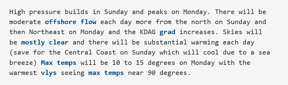
From NWS Los Angeles AFD
“There will be moderate offshore flow each day more from the north on Sunday and then Northeast on Monday”
Looks like at least some upper level support and cold air advection to go along with it.
7 Likes
Fire season is over in MMU and residents can start pile burning on the 23rd. it’s over on the east side of FKU as well just waiting for them to lift burn restrictions.
1 Like
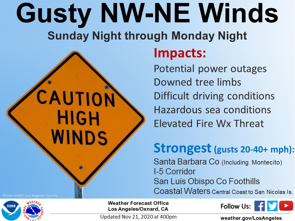
Local offshore winds today-tomorrow for some elevated fire weather in the typical wind favored locations. Gradients are strongest from the north at -5 so this favors the Central coast for elevated fire weather.
A weak and dry cold front drags across the area Monday in the broad NW flow, which will bump up the sundowner winds.
Forecast models bring in an aggressive inside slider into the Great Basin next week. The ridge is oriented N-S on model runs so it would be a critical offshore wind event. The often lameduck GFS shows LAX-DAG gradients peaking at -7.6 and a 24 hour pressure trend of -8.5.
The CMC and ECMWF suggest the low may cut off some, while the GFS is more progressive and flings it out of here quickly. It’s too far out to exhibit confidence right now, so will update in 2 days.
The climate models show anomalous ridging across the area through December, a grim sign for any precipitation potential.
4 Likes
Live Fuel Moisture:
1 Like
Thanks for the update on Fuels…Just one good Santa Anna to be back to where the were or close.
2 Likes
Models are all still on board for two offshore events this week- second appears to be stronger, while the first appears to be a little longer in duration…
6 Likes
And the hits just keep coming…
From NWS LA discussion:
ECMWF ensembles have been consistent with a moderate Santa Ana wind event by late Thursday and Friday. Newhall Pass ensemble data even has a few high wind members showing, but averaging between 40-45 mph. All medium models indicate a cold, deep trough will move across the Great Basin and central Rockies, but some uncertainty lies with the strength and placement. The ECMWF and GEM have trended stronger overall with a closed low over northwest AZ. There is plenty of time to build confidence in this wind event, but fire weather concerns could be a significant threat by late Thanksgiving Day and continuing through the weekend as very dry and warm conditions are likely to follow the winds. The GFS PWAT values drop below 0.15 inch Friday night to Saturday, which has a return interval of 2-5 years on GEFS ensemble data. Extremely dry for late November. The duration of dry and warm conditions could persist for a concerning multi-day period right into the first week of December. In fact, deterministic models show a stronger trough digging over the Great Basin and Rockies around Dec. 2nd which could reinforce Santa Ana wind impacts. Ensembles have a long period of gusts over 34 kts in the mountains that week which could be a critical fire weather stretch.
Another drier than normal month is looking likely to start our La
Nina winter season.
7 Likes
Huh
Talk about the beatings will continue until moral improves.
Wonder which IMT is on call this week too:thinking:
6 Likes
Forecast models and their ensembles in general agree on a moderate strength Santa Ana wind event starting Thursday night.
While this is not looking as strong as the event we had a few weeks ago, this will likely be a longer duration event. The chance of this becoming an outside slider is low, around 25%.
Highlights: at the peak, NE winds 20-30 MPH with gusts up to 45 MPH.
Offshore flow continues through the extended period, but upper level support slacks off by Saturday.
Some model runs drop another upper level low into the Great Basin for the beginning of December.
With no meaningful precipitation expected, the risk of having the strongest winds of the season overlapping a dry fuel bed is higher heading towards winter.
5 Likes
CF IMT3 this week CF IMT4 starts next Monday
1 Like
PS has High Risk days for this event in SoCal!
4 Likes
Good forecaste. I do concur based only on unscientific data, sort of like pain in the joints of us old folks. temps in Wrightwood, 6000 ft, canyon in the San Gabs, drop and we get no winds during a NE wind event. Looking at the temps during that period, it goes along with this wind event. while it will be a good thing for Mt. High Ski Resort to blow snow…it is not a good event for potential fires and behavior. So Cal is nowhere near to be out of a dangerous fire season…just on old guy with weather joint…more of a conformation only.
10 Likes
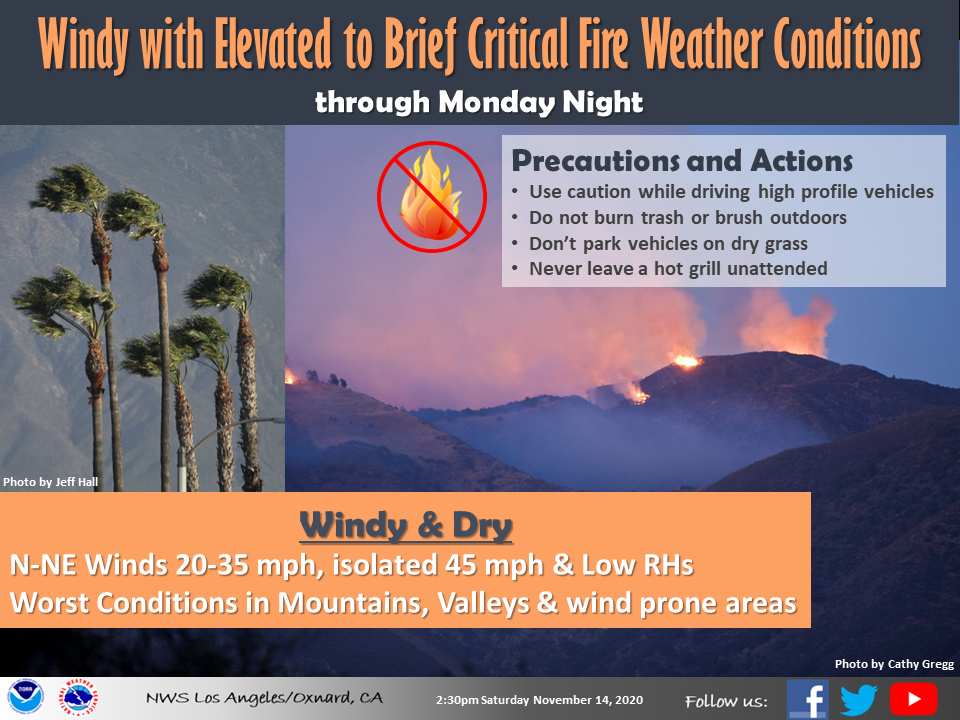
NWS LA: Increasing confidence that a moderate Santa Ana wind event with further drying will bring widespread elevated and possibly critical fire weather conditions for Los Angeles and Ventura counties Thursday afternoon into Friday, with the potential for needing a Fire Weather Watch. During the peak of the Santa Ana wind event Thursday night to Friday morning, preliminary estimates indicate the potential for wind gusts of 45 to 55 mph across the Los Angeles and Ventura county mountains, 40 to 50 mph across the valleys, and 35 to 45 mph across coastal areas. Offshore winds will diminish some by Friday night and Saturday, but humidities in the single digits and lower teens will potentially maintain elevated to brief critical fire weather conditions into Saturday across portions of Los Angeles and Ventura counties.
There is no precipitation in the forecast for the next 10 days.
7 Likes
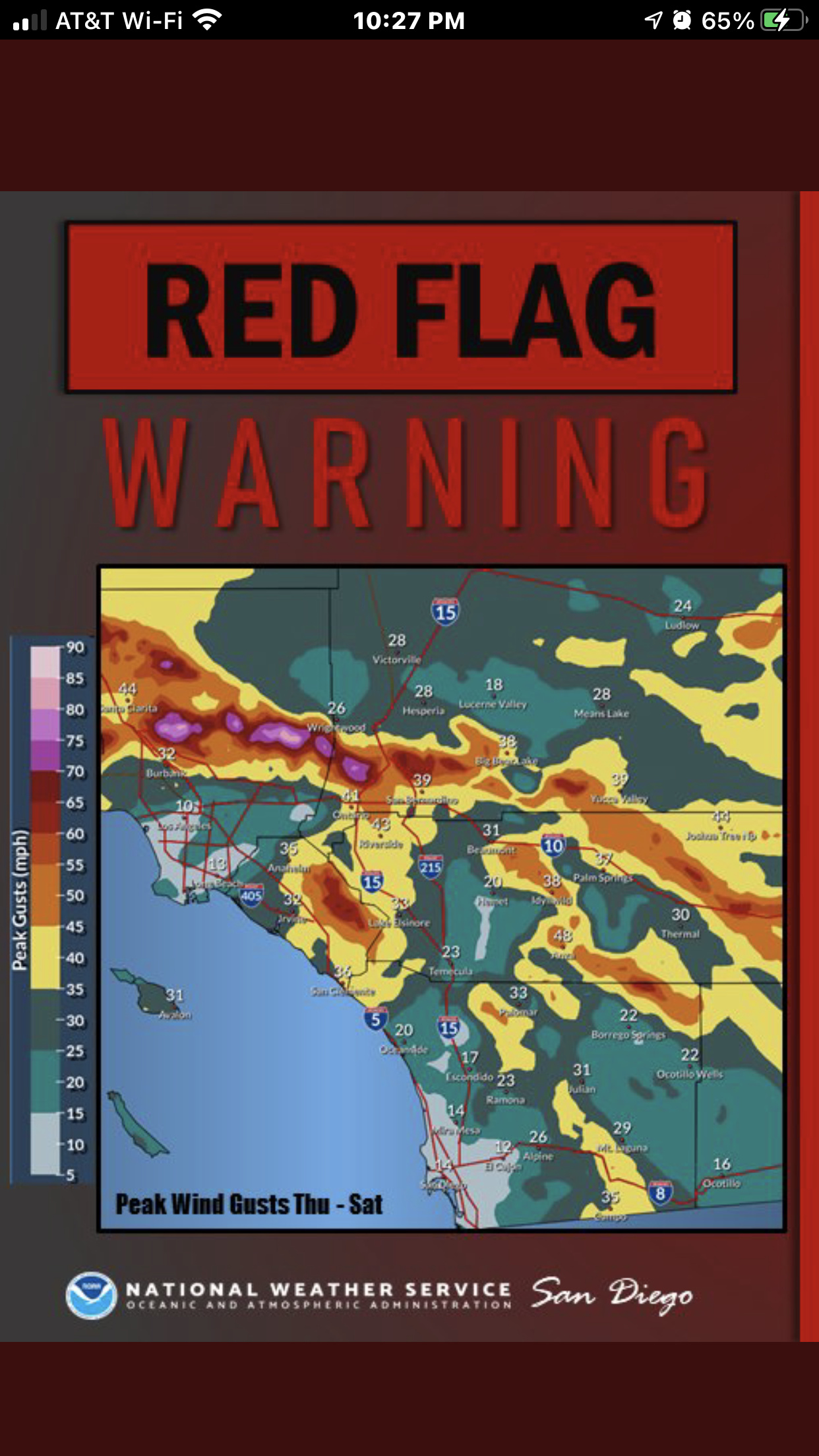
Red Flags flying for most of SoCal!!!
5 Likes