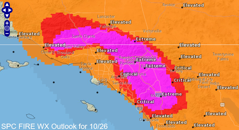
Good morning. The Storm Prediction Center has added “EXTREMELY CRITICAL” risk delineations for Monday, October 26th.
7 Likes
From the western edge of the creek fire in meadow lakes.
https://www.wrh.noaa.gov/mesowest/timeseries.php?sid=PG218&num=72&banner=gmap&raw=0&w=325
2 Likes
SoCal observations:
https://weather.sdgeweather.com
1 Like
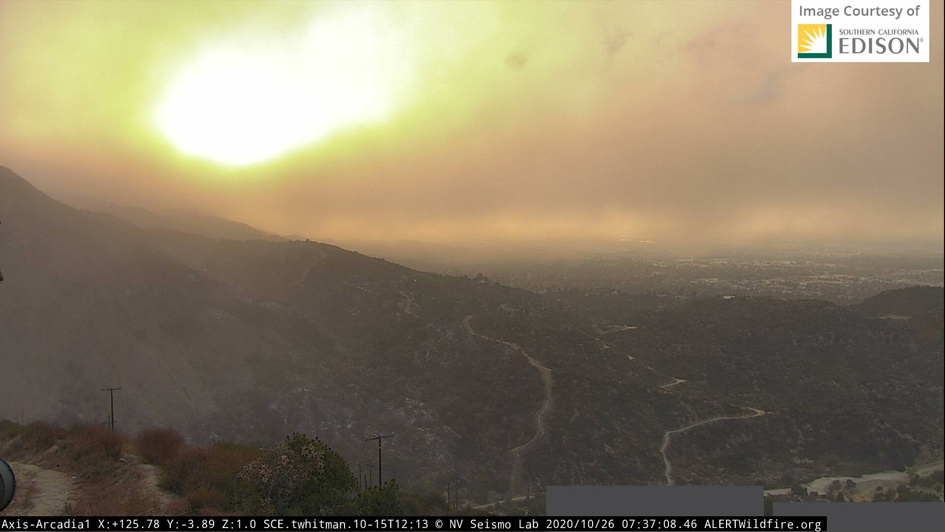
Significant ash plume with onset of offshore over the Bobcat. If you use the timelapse it reminds me of when the El Dorado pushed out into the flats this summer.
2 Likes
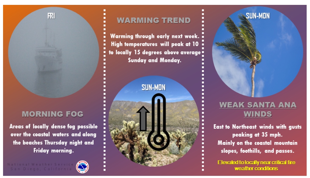
Interpretation of the upcoming forecast: flat ridging replaces the upper level low across CA through the next few days. Temperatures will climb slowly this week. Light offshore flow continues through the week battling onshore flow. A shortwave is going to dig into the upper midwest and eastern US on Saturday which amplifies a strong ridge for this time of year overhead of CA. Temperatures will be above average this weekend into Monday with gradients trending offshore. Weak-local moderate Santa Ana winds may develop however at this time there is no trough axis or cold air advection to boost winds.
Storm prediction center highlighting Santa Ana potential this weekend:
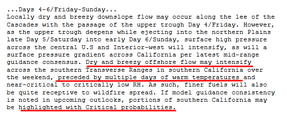
A bare bones cut off low is just offshore Southern CA and if another inside slider digs aggressively across the Great Basin it could interact for a repeat scenario of this Santa Ana wind event. Most models though have Omega blocking across the Central US through election day with above average temperatures and no cold intrusions into the Great Basin through the next 7-10 days.
Update: this matches up with NWS SGX AFD.
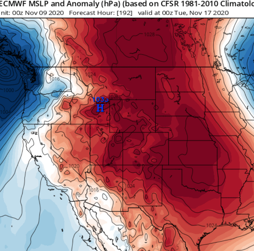
Extended outlook hazards: after an extreme pattern of omega blocking from Mexico into the northern plains through the 3rd of November ensemble means agree that a very long wave trough will develop from Washington state into the east coast with individual shortwaves embedded within the flow.
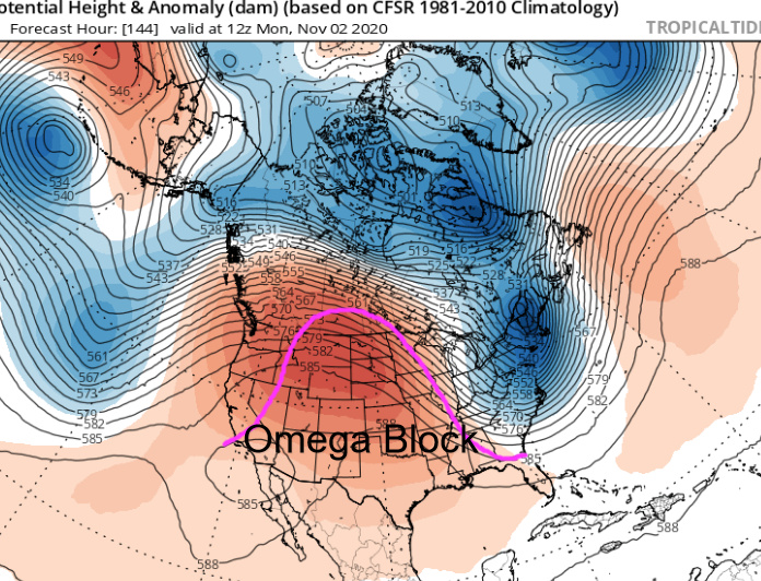
The amplified pattern will continue as it is likely the intense ridging across the Southern US will split and allow another cold air intrusion into the Great Basin perhaps starting on the 7th. The next storm system will either bring CA’s first widespread precipitation event of the year or an extended period of offshore winds. There is a lot of runway between now and then but w/ the mindblowingly amplifed pattern across the US (almost seems like a weather machine or simulation) the chance for a long duration, strong offshore wind event is higher than average.
10 Likes
SoCal Forecast
Current Local Weather:
https://sdgeweather.com
Wind Data last 48 hours:
https://nwschat.weather.gov/p.php?pid=202010272215-KSGX-NOUS46-PNSSGX
4 Likes
Interesting if this will progress into a Fire Weather / Red Flag Event.
1 Like
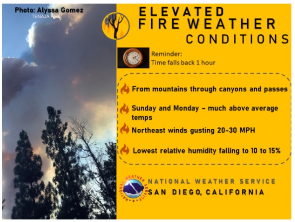
Fire Weather Forecast
5 Likes
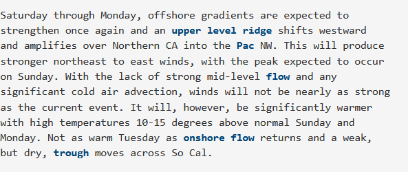
The GEFS continues to advertise an inside slider on the 8th of November. Operational model trending towards an inside slider as well with cyclonic flow producing a deep marine layer precipitation beforehand. While the big trough moves over the Great Basin into the plains a nasty shortwave rotates out of Canada around the trough and could bring a reinforcing shot of offshore flow. It could also bring decent rain/snow to CA. Could go either way at this point. We are starting to get into the higher resolution data points so will help clear things up soon.
11/2 latest runs of the GFS and ECMWF would bring a potentially damaging onshore wind event with this aggressive inside slider followed by an offshore wind event as a shortwave rotates around the trough and drags a surface high pressure with it. As this occurs a 140 kt jet moves overhead for excellent upper level support. Latest GFS run shows good potential for mountain wave activity.
8 Likes
I vote for rain and snow.!!! Tired of the PSPS and running off the generator. Everyone and everything is stressed form people to equipment to trees and wildlife. It’s time for some weather, not windy weather!
14 Likes
GFS seems to me to be trending wetter the last few runs? Also, unsettled pattern seems to stick around for a while. I know inside sliders are very finicky up to a day or two before storm but is it looking promising for the storm door to be open for showery weather the next 1-2 weeks? NWS CPC 6-10 day outlook seems to support this.
3 Likes
All models trending wetter today. Fingers crossed.
Increasing confidence of a damaging onshore wind event on 10/7 and 10/8… With chaotic showery cloud pattern. GFS has onshore gradients + 7.1 LAX-DAG but also -3.0 LAX-BFL. A strong NW wind with cold air advection & upper level support.
From NWS Los Angeles:
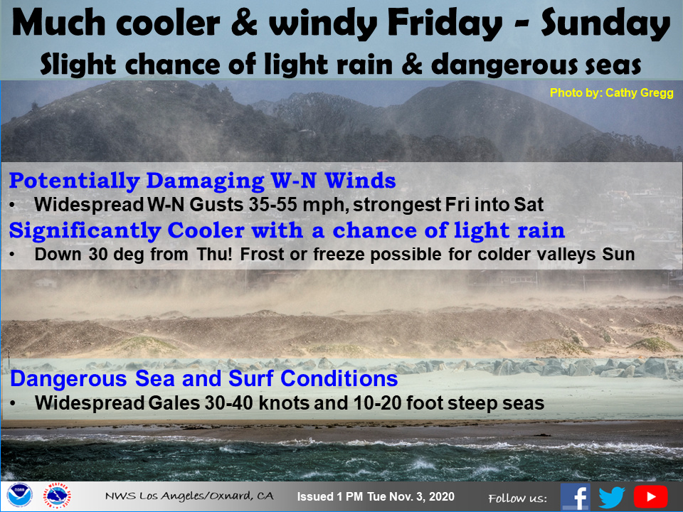
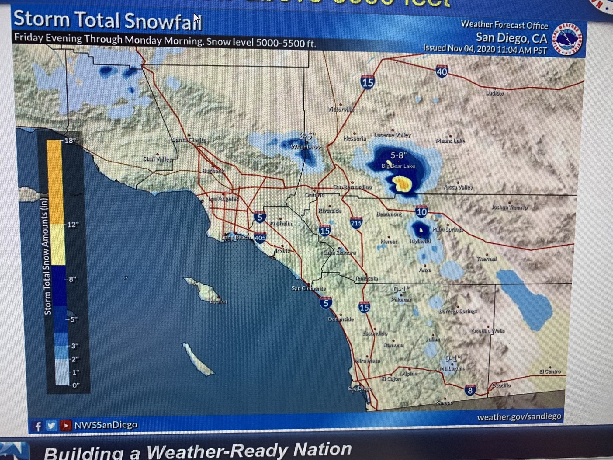
The Sierra Nevada could see some decent precipitation in the upper elevations. The NW flow into Southern CA cuts down on precipitation. Whatever rain falls likely won’t be fire season ending.
10 Likes
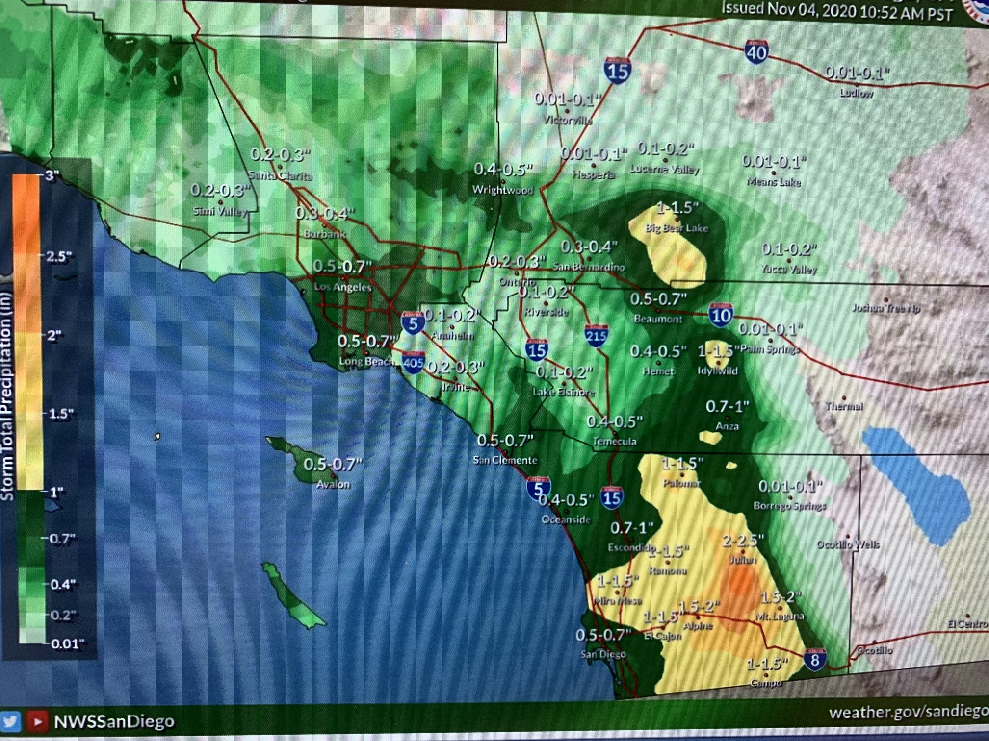
Weather discussion… so far the outside slider is under performing in regards to precipitation up north. I was kind of skeptical that this would be a big rain maker for anywhere across the state. We will have to watch and see if daytime heating kicks off any thunderstorms. This set up really favors the San Diego Mountains for precipitation due to the NW cyclonic flow aligning with the mountains/most over water track. The second colder shortwave will be further inland so if the first low fails to deliver expected precipitation the second one will likely as well. Will have to watch. Tricky.
Damaging onshore winds will occur on the desert slopes and increasing fire danger there, despite the higher humidity and low temperatures. Models are pretty impressive with onshore winds across all of Southern CA.
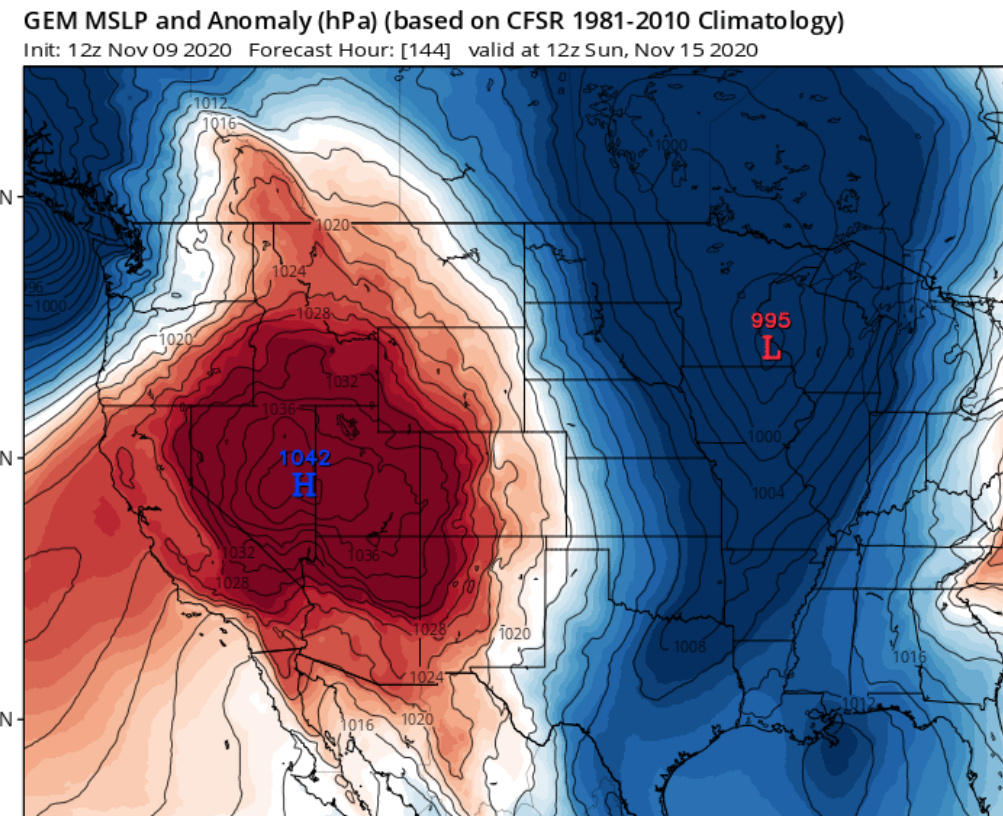
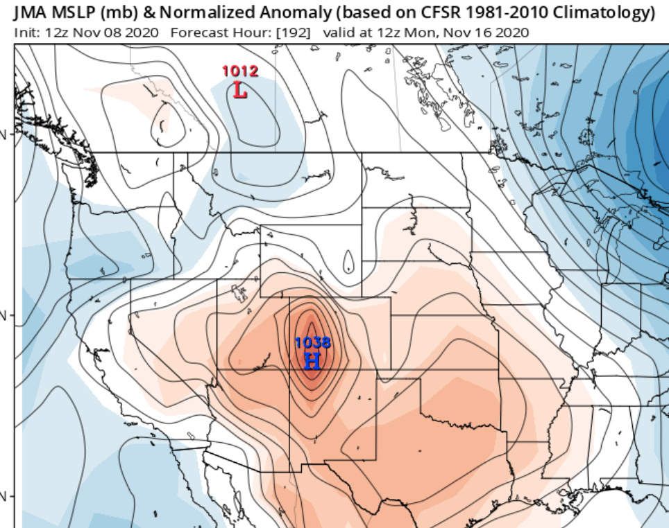
After the trough axis moves into the Great Basin several shortwaves rotate around it, dragging a surface high pressure with it. Instead of the initial trough axis being unclear of where it sharpens and digs, it is very clear that the big trough will settle across the northern US and sharpen shortwaves across the Great Basin. Therefore, instead of the low-medium confidence that was displayed for a Santa Ana wind event for 11-7-11-9, the potential for offshore winds during the 11-12-11-16 time period is medium to high. The strength of these winds are still in question, but the general pattern is very favorable for cold air advection and upper level support
So we should hope for as much wetting rain as possible from this disturbance this weekend, because probably no rain for the next 10 days unless things change.
10 Likes
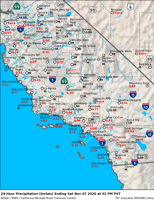
Snow just above auberry and it’s been raining off and on through out the day.
After a period of broad NW flow across South Ops and drying through the extended period, and the aforementioned possibility of a Santa Ana wind event… forecast models are suggesting a weak atmospheric river moving through at least the Central Coast next week… which if it comes to fruition would likely delay fire season for 2 weeks
The CMC is an outlier which suggests the potential for Santa Ana winds all through out next week.
3 Likes
I am not an expert at weather, but I know how to read all the weather models and there is no East wind event forecasted for SoCal.
1 Like
The GFS shows a more progressive pattern with N-NW flow rather than the ECMWF and CMC showing some offshore flow.
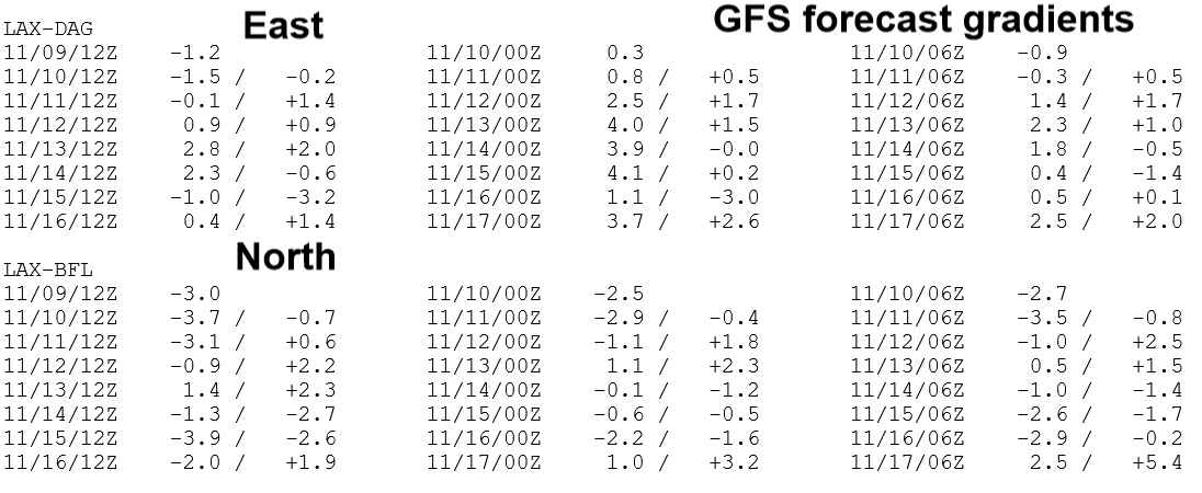
The EC is about -4 offshore LAX-DAG and the CMC is severe at -9
4 Likes
I wish I understood the graphs and charts.
4 Likes