We here in SoCal are going to have our own red flags flying come Monday!!
5 Likes
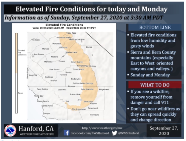
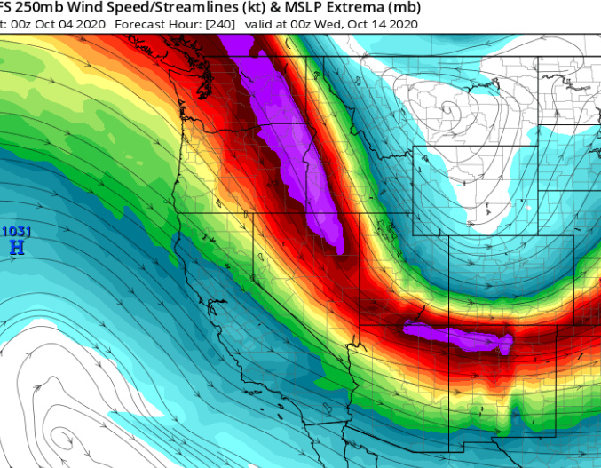
Should see some critical fire weather conditions but the coverage level is in question. Ultimately the strongest winds could be on Monday or Tuesday… the challenge will be the strength/position of any shortwaves rotating around the big trough over the mid west, which models can struggle to pick up. Shortwaves are pieces of energy/vorticity.
From SPC:
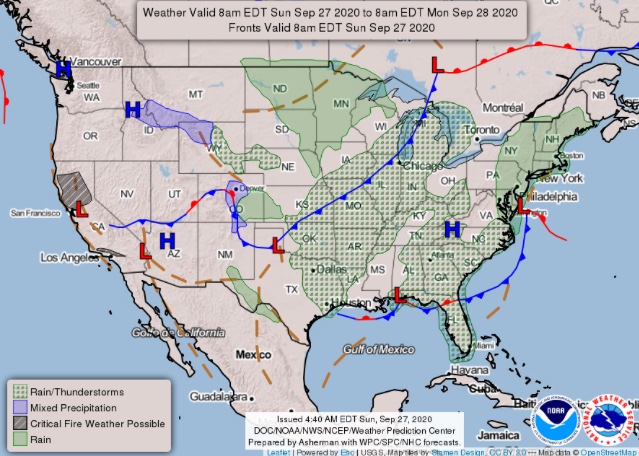
“…California…
The area of high pressure building into the Great Basin Day 3/Sunday
is forecast to support offshore winds across northern and Southern
California before shifting south through next week. Record warmth is
expected under the ridge, favoring hot, dry, and unstable conditions
across much of the West. Offshore flow is forecast to increase
through Day5/Tuesday bringing the potential for downslope and Santa
Anna winds to much of southern California. Low humidity and gusty
conditions are expected, with poor humidity recoveries overnight.
While models remain somewhat uncertain on the most favored corridors
at this time, downslope winds, very favorable fuels, and record high
temperatures will likely support widespread critical fire weather
conditions early next week. Several 40% probability of critical
zones have been added, and will likely be upgraded in coming
outlooks.”
Will have to watch and see what happens because winds could overachieve.
7 Likes
https://gacc.nifc.gov/oscc/predictive/weather/myfiles/Webcast.html
Good webcast from this morning.
5 Likes
Regional Forecast
Watches and Warnings
https://www.weather.gov/wwamap/wwatxtget.php?cwa=sgx&wwa=all
Central Valley
2 Likes
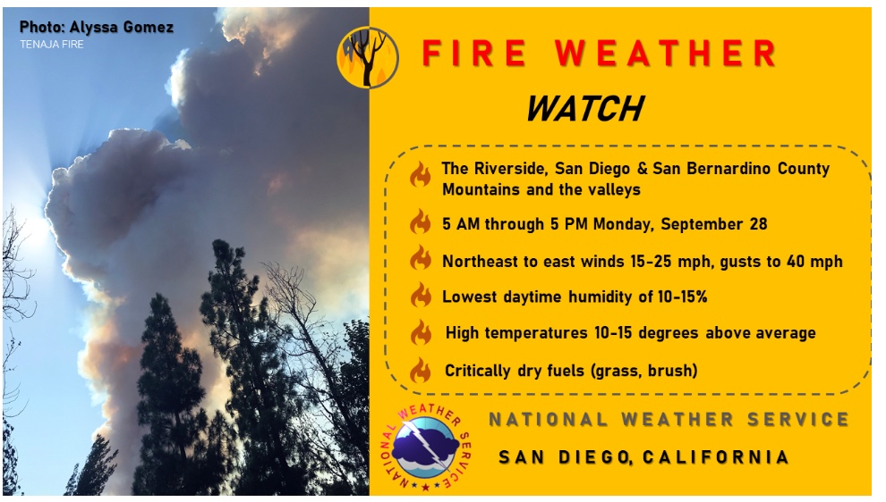
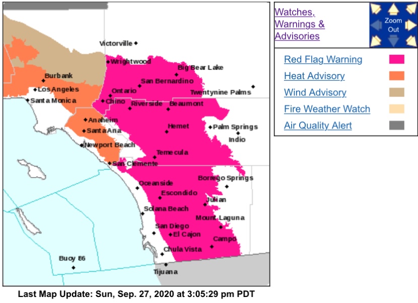
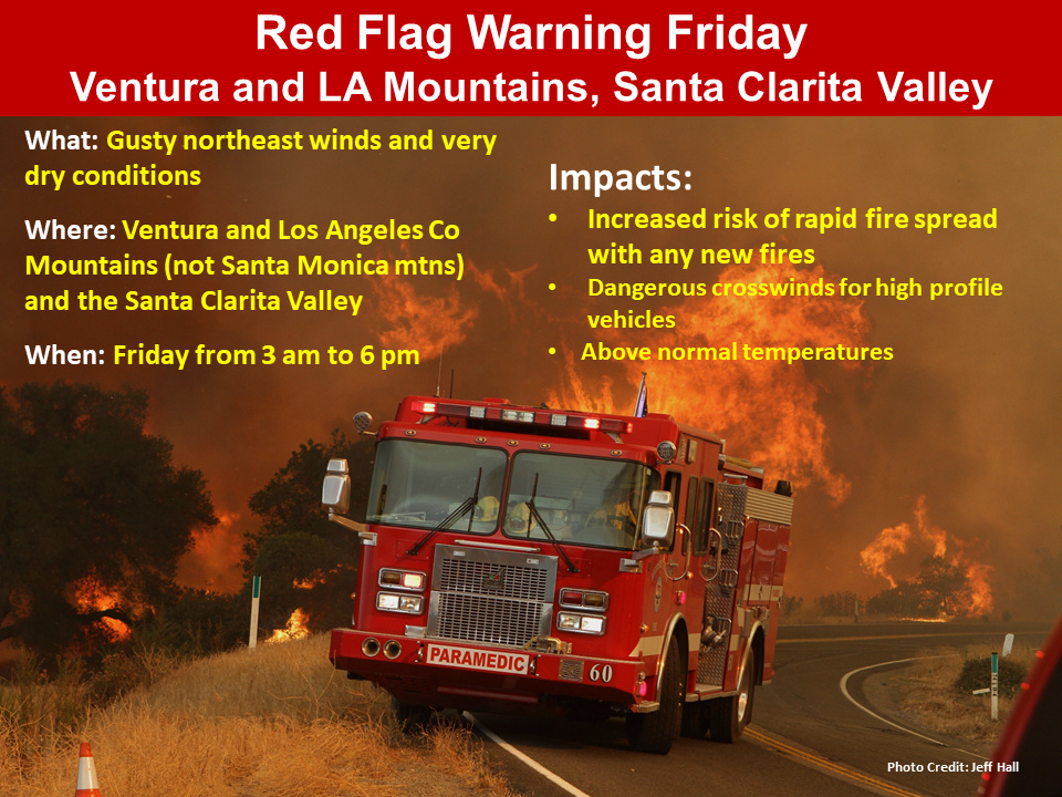
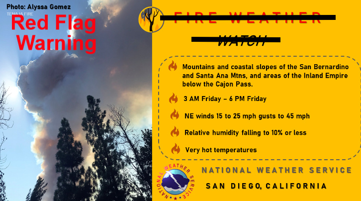
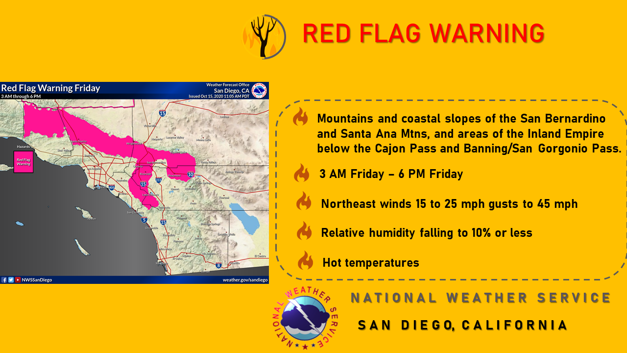
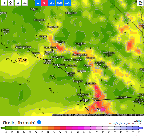
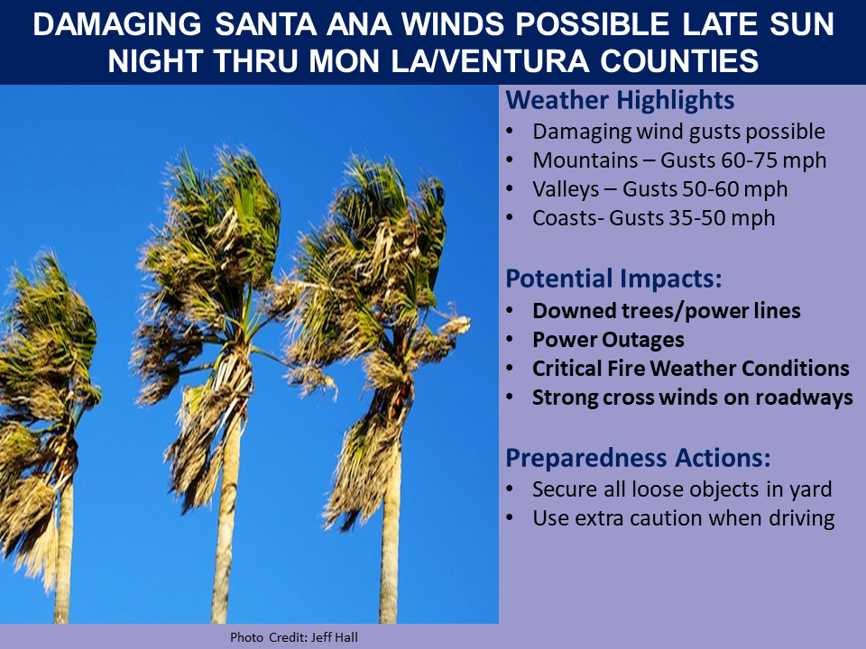
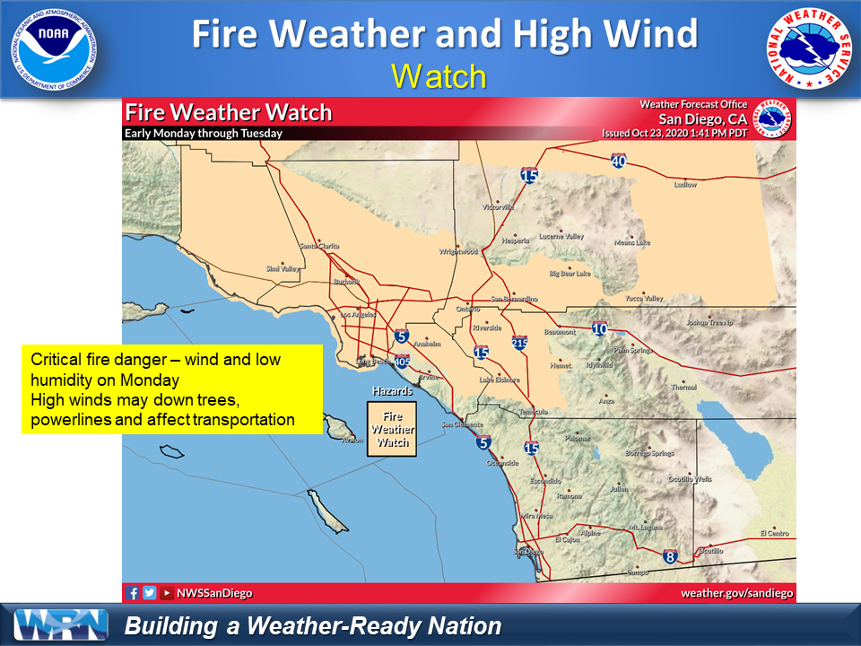
Fire Weather Watch has just been upgraded to RFW for SoCal!!
6 Likes
Gradients are trending offshore this morning and should ramp up a bit as the day time heating increases the gradient. The forecast for localized moderate Santa Ana winds w/ hot temperatures and low RH looks good.
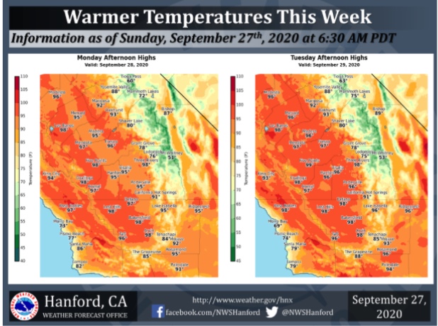
Ridging is going to continue all week for above normal temperatures enhanced by light offshore flow.
The long wave trough will continue over the Eastern US and we will have to watch to see model trends on if any shortwaves move further west around the big trough into the Great Basin.
If this pattern holds for the next 7 days I would expect a bigger Santa Ana wind event around the 6th-8th time frame of October, as the next Alaska low cycles into the jet stream.
7 Likes
Challenging forecast ahead.
Anomalous summer like ridge will persist across the western US through the end of the week, shrinking and flattening out into the weekend.
A tropical cyclone (Kujari) near Japan in the Western Pacific is forecasted to be absorbed by the Alaskan low and help enhance the trough across the Central Pacific. At the same time, a hurricane forms in the eastern pacific and moves NW through the weakness in the ridge at the same time the trough is picking it up.
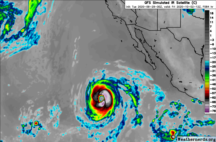
The last two runs of our global models (ECMWF and GFS) have this storm getting flung at Central or Northern CA, or Oregon as a subtropical cyclone… around 10/9. On the latest model runs it legitimately makes landfall as a sub-tropical cyclone.
This is a very rare scenario, and there is a possibility that the trough misses the cyclone and this post is hogwash… but the most logical impacts on our weather is may be some cooler weather, clouds, and this circulation could destabilize the Arctic airmass leading to a cold snap across the Great Basin or midwest towards the middle of the month.
This is all just grasping at straws at this point but this tropical cyclone has a 90% chance of developing in the next 48 hours and if it recurves as depicted by models it will impact our weather significantly.
10 Likes
Great post. How will this affect So Cal and Nor Cal? Precip? Lightning? Hail?
2 Likes
A long way out but hints of rain south to Fresno 2 weeks out…
2 Likes
Very very challenging forecast continues.
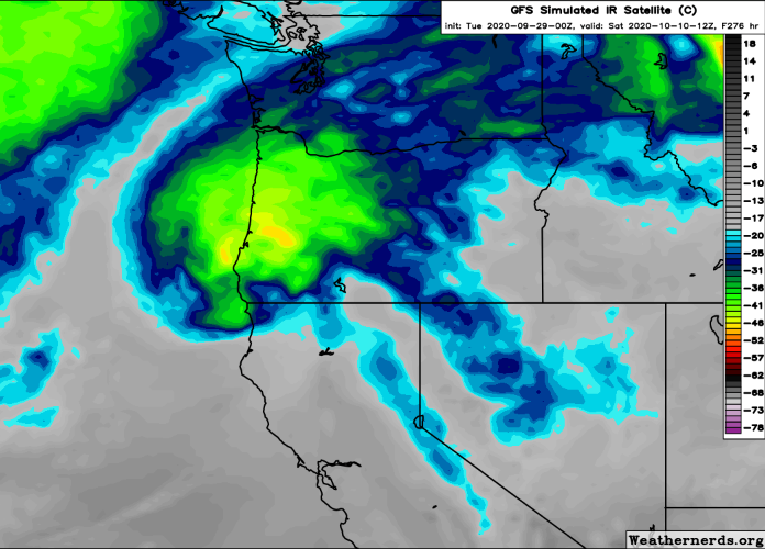
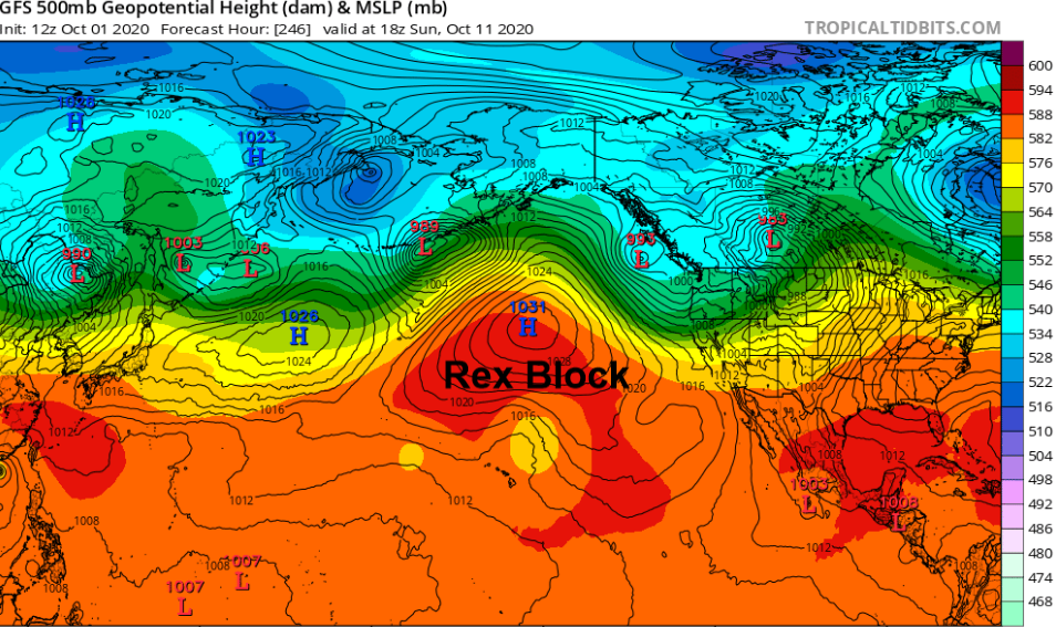
Instead of Marie being recurved out towards the CA coast latest model runs show the trough cutting off into a cut off low and absorbing Marie well offshore. This upper low interaction develops a rex block in the Central Pacific. This scenario would open up the door for a deep trough along the west coast. Models continue to trend towards this scenario. Early season depictions of troughs across the Western US tend to be too far west. Any precipitation depiction in Southern California more than 5 days out this time of year should be discounted. 15-30 degrees of cooling looks good for most areas along with a deep marine layer, starting around the 10th. The exact track of the trough will determine offshore wind potential. Because models show this monstrosity of a trough developing it is slower to move into the area and offshore winds are no longer expected on the 7th-9th time frame.
7 Likes
I know this is very far out (10 days) but my confidence for a Santa Ana wind event with good upper level support, cold air advection, and a solid gradient is increasing… for the 10/13 to 10/15 time frame.
Tonight (10/3) run of the GFS continues to trend towards a Santa Ana wind event with the trifecta of ingredients needed for a moderate to strong & long duration wind event.
Pressure gradient: Let’s call it -7 LAX-DAG & -14 LAX-TPH as of right now.
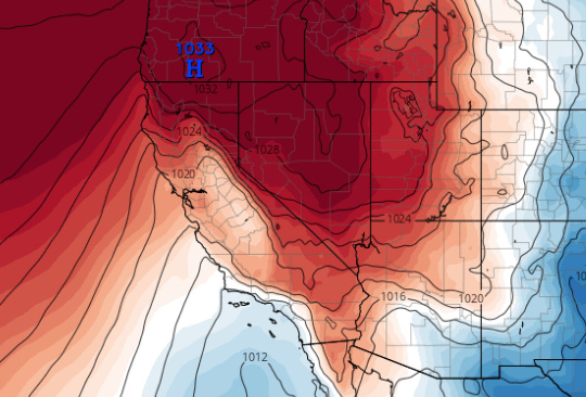
Upper level support: jet stream is right over the surface high pressure area
Cold air advection: model shows cold air advection and a classic Santa Ana thermal gradient east of the mountains (below average) and west of the mountains (above average)
10/6 update
This mornings run of the ECMWF is ultra aggressive with a multi-day moderate-strong Santa Ana wind event. Global model ensembles continue to show a Santa Ana signal. Operational runs continue to see-saw between intensity.
15 Likes
Deleted a reply above so I can post again.
The NAM peaks offshore gradients at -7.4 Friday morning which is a critical gradient for the typical Santa Ana favored locations.
On the extreme opposite the GFS peaks gradients only at a mere -1.3
The EC peaks gradients somewhere in between the two.
An extended period of offshore flow with hot temperatures (10-20 degrees above normal) and breezy conditions + low RH will lead to elevated to critical fire weather conditions through Saturday. The ridge did not end up changing it’s shape as earlier model runs have indicated and have kicked that can down the road further… so we won’t be getting cold air advection and upper level support to drive a strong Santa Ana wind event. We will see locally moderate Santa Ana winds and locally strong Sundowner winds in the terrain favored locations. Red flag thresholds with NE winds 15-25 mph & gusts to 35 MPH and RH 8-15% may be met Friday… so be on the lookout for that
The persistence of the strong subtropical ridge has been incredible, but models continue to erode the eastern side of it verrrrrryyyy slowly… which would open the door for stronger offshore winds the second half of the month. I would be shocked if this strong of a ridge continued into the second half of the month because it’s pretty unheard of even for early October. We should be firmly into a fall regime with upticks in offshore winds through the rest of the month. There is no precipitation signal in the next 10-14 days.
7 Likes
Here’s your ticket for 3 more excellent posts in a row. Thanks! cough now do north ops cough
9 Likes
Tonight’s sundowner winds on the fire wx snooper:
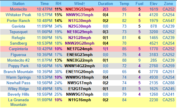
5 Likes
LAX-DAG gradient peaked at -5.1 today, kudos to the NAM-WRF for modeling the pressure gradient the most accurately. This gradient was above what was forecasted. Since the Santa Ana winds were mostly gradient driven they were not that strong or widespread.
Looking ahead… the long wave trough will continue to persist across the upper midwest and Great Basin through much of the week. The ridge above us is flattening out… so gradients will not trend strongly offshore at least for the next few days. The flattening ridge will promote cooling and higher RH.
After about 5 days things get interesting. A very weak upper trough leftover from the remnants of tropical storm Norbert will move in from offshore, at the same time a sharpening and very cold trough moves in from the barren north. The weakness in the ridge will allow this trough to move further west into the Great Basin, potentially bringing a record type cold event to the Great Basin and Western Plains. The extremely vigorous and cold trough moves over an airmass that has already seen record cold air, doubling down on the chill. This could bring our first traditional cold air driven Santa Ana wind event of the season.
This situation is only in the mid range of the forecast window (pattern starts around 10-22) and will definitely need to be monitored on a run to run basis. Like usual, the differences between models currently is the placement of the trough and the cut off low offshore of CA.
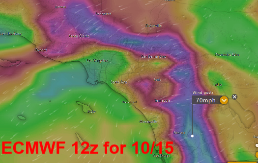
Quick update 10/20… CMC and ECMWF have trended the upper level trough into Southern CA which would bring cold weather and possibly rain. The GFS and ICON bring a sharp trough just east of the mountains for a classic Santa Ana wind event.
ICON
I think the CMC and EC are a bit far west… due to climatology and would expect an eastern adjustment. If this upper level low cuts off as EC suggests, but east of the mountains we could see some decent mountain wave potential due to significant upper level support and cold air advection for a long period of time.
The key points: differences in model runs continue but expect a dry set up/back door cold front with maybe some drizzle. The mean between all models and their ensembles is potentially volatile for offshore winds… and we will get a model consensus for upper feature positions as we get within the 96 hour range and have more data points to work with. So continue to monitor.
10 Likes
Nothing like Nor Cal, but So Cal will get some winds as well. There may be some precipitation before the wind arrives, so we will see how this plays out. As usual Simi Valley looks to blow pretty good.
5 Likes
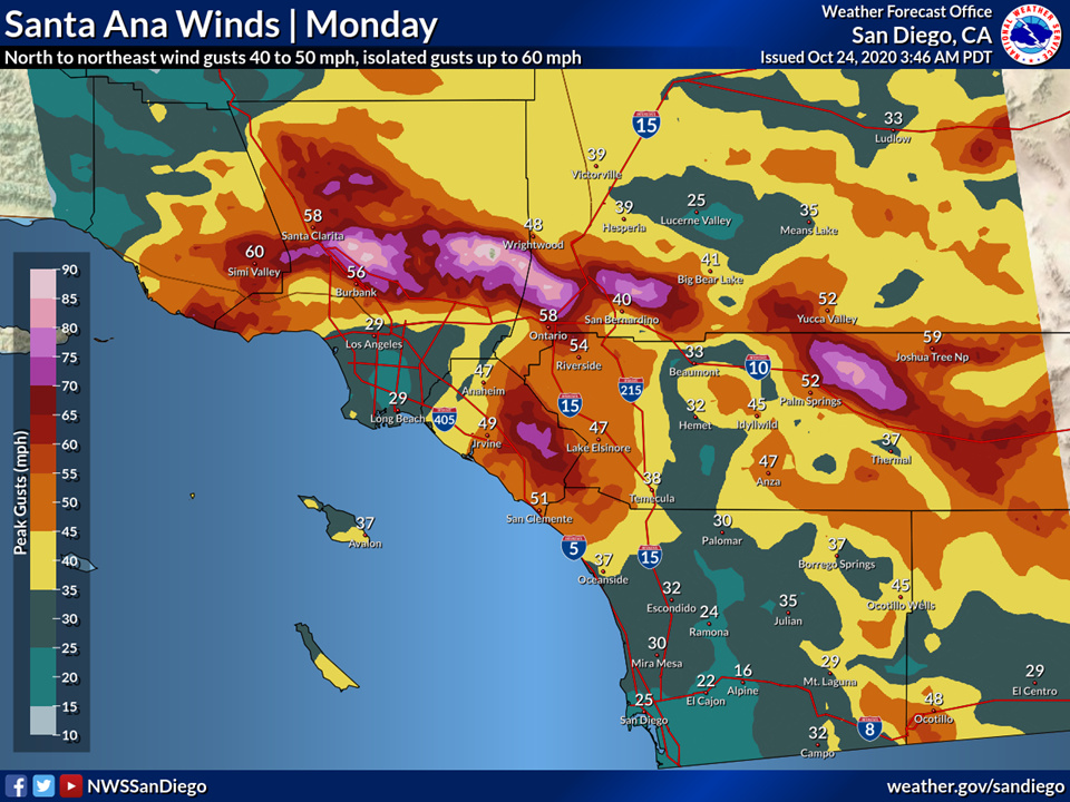
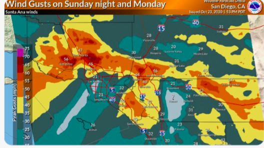
A high wind watch is now in effect for the Los Angeles County Mountains, Ventura County Mountains, Santa Ana mountains, San Bernardino County mountains, Riverside county mountains, and Inland Empire.
8 Likes
Thank you.
1 Like