Kinda reminds me of a thermocline(spelling?) or whatever the warm air layer in a valley is called that’s pleasant(5 degrees or so warmer) to pitch your tent in at night… not at the floor but not too high, just usually about 20 feet or so up…
yes, could be from fires in different air masses.
1 Like
When the air is calm, (unmixed) the atmosphere tends to develop many layers (“inversions”) within the larger inversion that we call the troposphere (the lower atmosphere). If you have a chance look at the temperature plot from an atmospheric sounding (Weather Balloon). There tend to be many little ripples in the temperature line. Those are all little “inversions” where warmer air is trapped under cooler air that is sinking because it is heavier.
Pretty fascinating.
5 Likes
Do you see the possibility of a possible 6 day event of NE winds next week???
1 Like
I see the possibility of some weak offshore winds next weekend. Nothing major at this time. The sundowner wind event might be an advisory level wind event.
More bullish for Diablo winds up north. Due to Omega blocking across the Southern US the trough does not dig south into Nevada… it just heads east in the northern part of the US.
4 Likes
thank you for your more up to date interpretation. mine was from the older guys that taught us that Santa Ana winds TEND to blow in 3 day cycles. worked most of the times but technology has moved a bit forward in the last 40 years. always willing to learn new things. again, thank you for your insight.
2 Likes
Everything is tied together. The next 10-12 days looks pretty benign for us… but these tropical cyclones will be moving north, destabilizing the Arctic airmass and eventually re-amplifying the pattern across the US breaking down the Omega block. The amount of tropical cyclones (possibly 5-10) over the next 2 weeks moving into the north pole region is pretty insane. The ridge tends to be on a 10-14 day cycle for us. We just had one of the most amplified high pressures in history… and we are on the down cycle of the amplification cycle… the problem is that as of now heights are still very high so when the pattern reamplifies & you’re adding all of these tropical cyclones into the north destabilizing the Arctic airmass it’s looking like a pretty insane end of the month and/or beginning of October.
Essentially, the longer this Omega block continues across the Southern US… and the more tropical cyclones that cycle north into the Arctic… the higher the potential becomes for a strong destabilization of the Arctic airmass becomes.
6 Likes
I admit that I do not fully understand your technical jargon…but it in layman’s terminology means bad fire weather ahead…possibly.
2 Likes
Let me know what you are confused about and I’ll break it down… but yes, it’s looking like a brutal offshore wind season.
10 Likes
you as usual you answered it. thanks …looking forward to your next post
learning…slowly…be patient
8 Likes
I suggest following Weather West, it is full of weather nerds like me that are eager to learn.
1 Like
I think that the trough moving into the Pacific NW will likely bring some rain to far northern CA, and drizzle along coastal slopes. Forecasted precipitation has trended drier then it was a few days ago though, but the impact here in South Ops will be pretty minimal. A couple degrees cooler and stronger onshore winds.
Some remnants of Karina will be picked up and move into the area early this weekend. With any tropical remnants there is always the chance of a trigger not picked up by models that could initiate some isolated convection, but the chance is probably less than 15%.
All eyes on what happens with Hurricane Teddy. I am leaning towards Teddy moving close to the eastern US and interacting with a trough, with the model guidance showing a category 4 hurricane. Whatever happens with the Teddy-trough interaction could greatly influence our weather at the end of the month as the low (ex-teddy) moves back around the globe.
3 Likes
The latest sea surface temps in the 3.4 region of the Pacific seem to be dropping quicker than predicted. I wonder how quick a mild to moderate La Nina would influence the Atlantic. The atmosphere definitely seem to be in alignment, what with the five named storms and all. This is a good time to see where the Madden Julian Oscillation is right now.
3 Likes
Sundowners begin this afternoon…
Santa Barbara County South Coast-Santa Barbara County Mountains-
Including the cities of Santa Barbara, Montecito, Carpinteria,
San Marcos Pass, San Rafael Wilderness Area,
and Dick Smith Wilderness Area
929 AM PDT Fri Sep 18 2020
…WIND ADVISORY IN EFFECT FROM 4 PM THIS AFTERNOON TO 9 AM PDT
SATURDAY…
-
WHAT…North winds 15 to 30 mph with gusts up to 45 mph
expected. -
WHERE…Santa Barbara County South Coast and Santa Barbara
County Mountains. -
WHEN…From 4 PM this afternoon to 9 AM PDT Saturday.
-
IMPACTS…Gusty winds will blow around unsecured objects and
make driving difficult, especially for high profile vehicles.
Tree limbs could be blown down and a few power outages may
result. -
ADDITIONAL DETAILS…When driving, use extra caution. Be
prepared for sudden gusty cross winds. Gusty cross winds may
impact roadway such as Highways 101, 154 and 192…as well as
the Gaviota and San Marcos Passes.
2 Likes
Regional Forecast
Central Valley
Watches and Warnings
https://www.weather.gov/wwamap/wwatxtget.php?cwa=hnx&wwa=all
National Forecast Map
2 Likes
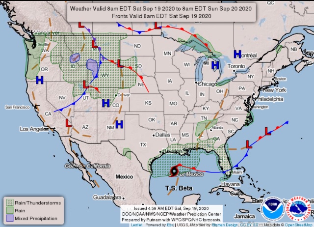
Watching the potential for Santa Ana winds around 9/27. It’s still far out and models are not resolving some other issues namely TS Beta very well. An anomalous trough is going to move into the Pacific NW, what happens with it is still unknown as some runs it is sharp through the great basin, other runs it is farther north, and some runs it cuts off over NM. Taking the middle ground, light offshore winds and rising temperatures west of the mountains look good… for now.
5 Likes
Large trough is forecasted to move progressively over the north 9/25-9/26 and then sharpen in the Eastern US. This amplifies a 598-602 DM ridge over California, which is an event that has a return interval for this date around 1 in 50 years (might be even longer).
This type of set up is difficult for us to get strong Santa Ana winds because the surface high is too far north and east, as is the upper level wind support. This is a gradient driven event (not much cold air advection) and the most likely scenario is HOT temperatures (possibly 110 in hottest areas) low RH, and offshore winds in the 25 MPH range above 3,000’. Other than record breaking temperatures… plume dominated fire behavior as well as restricted visibility due to lack of smoke dispersal will be a major challenge.
Now to the big picture: my intuition tells me this big trough in the eastern US is going to carve away at the ridge and possibly open the door for a major inside slider further west, between 9/31-10-4.
Things will likely change a little as we are still 5 days away.
10 Likes
Pretty ominous sign for what the entire fall might be like!!
2 Likes
Same thing I posted in North Ops applies for South ops. Still not a clear widespread strong Santa Ana signal yet but each model run has nudged further and further west with the trough over the midwest… so will need to watch this trend.
7 Likes
With the upgrade to red flags for not cal how’s that going to effect us in so cal?