The next chapter begins.

South Ops fire perimeters 2020
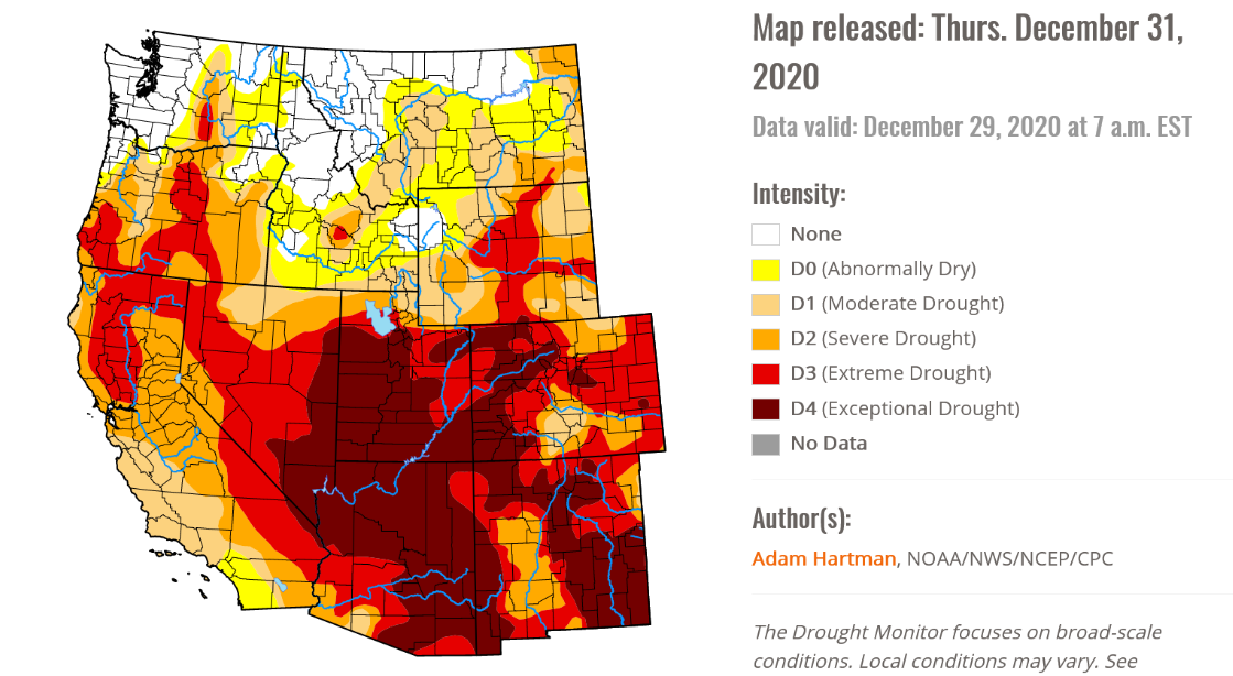
Southwest Drought Monitor 12-31-20
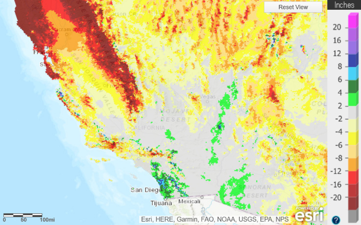
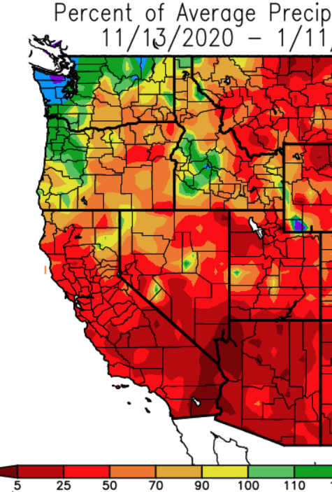
Departure from average precipitation 12-31-20 (full 2020, not hydrolic year)
The next chapter begins.
Southwest Drought Monitor 12-31-20
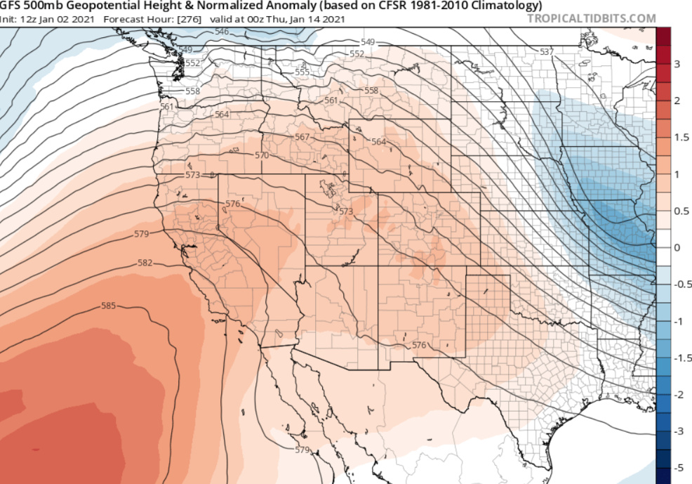
NW flow over Central CA will occur while a ridge noses from the Pacific into Southern CA. Several shortwaves in the flow will fluctuate temperatures a little each day, but overall a warming trend will occur. An amplified pattern will likely develop with strong ridging for this time of year just off the Southern CA coast through the middle of the month.
The amplified pattern will promote strong low pressure system over the Great Basin in the middle of the month, that leads to either cold continental backdoor low pressure system across Southern CA and/or additional Santa Ana winds.
Recent rains could sprout a small grass crop that cures quickly in the dry conditions. The precipitation forecast at this time is grim.
Weather Discussion:
A ridge of high pressure will remain centered west of Baja California through Monday.
This ridge of high pressure will strengthen and become centered off Point Conception
Tuesday through the end of next week.
North winds of 20 to 30 mph with gusts to 50 mph will surface across Santa Barbara
County and the Grapevine tonight.
Otherwise, there will be local north to east winds of 10 to 20 mph with gusts to 35 mph
across the mountains and below the canyons and passes of Southern California through
the end of next week.
Temperatures will remain 5 to 10 degrees above normal through Monday, with upper
40s and 50s across the mountains and mid-60s to upper 70s in the coastal valleys.
Temperatures will warm to 10 to 20 degrees above normal Tuesday through the end of
next week.
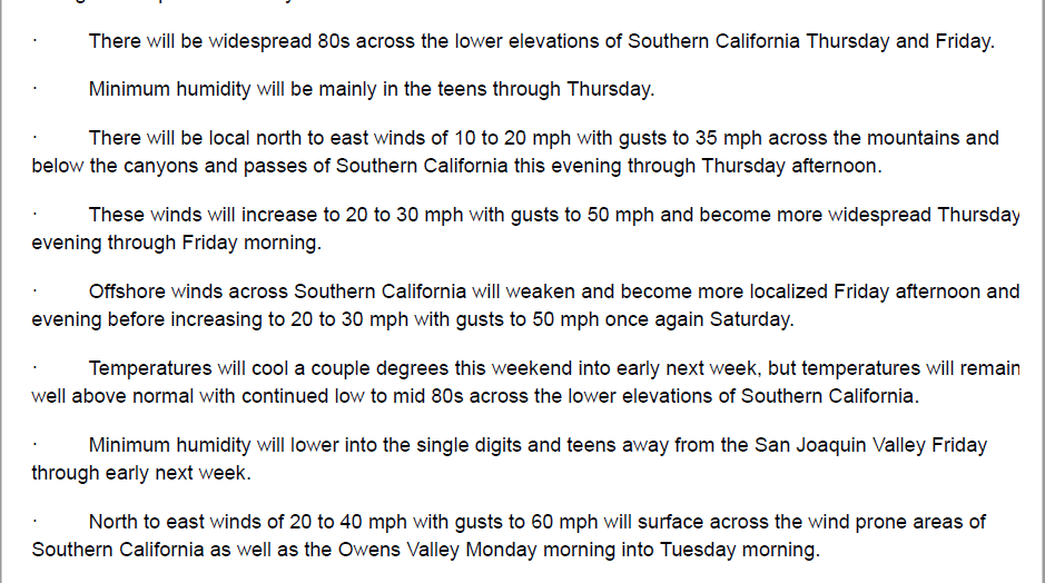
There will be widespread maximum temperatures in the low to mid 80s across the
valleys of Southern California Wednesday through the end of next week.
Minimum humidity will remain mainly in the single digits and teens away from the San
Joaquin Valley and coastal areas through the end of next week.
There will be no rain across the entire region through the end of next week.
Fire Potential Discussion:
Strong winds and fairly low humidity will bring an elevated threat for large fire to Santa
Barbara County tonight.
Even though it will be windy over the Grapevine tonight, the large fire threat will be lower
than across Santa Barbara County since humidity will be much higher.
Otherwise, the potential for large fire will remain low across the region through the end of
next week.
Warm and dry conditions will continue to cause the dead fuel moisture to decrease
through the end of next week.
Light initial attack activity will continue through the end of next week.
Highly amplified pattern will develop by mid week as high pressure moves from off the Southern CA coast into much of CA. High temperatures will bump up 5-20 degrees above normal during the next week or so. There is a solid chance of mid 80’s for much of the interior valleys.
Surface high pressure will develop over the Great Basin. Light offshore winds will compound drying across South Ops.
After the ridge reaches peak amplification around the 20th, a low pressure system will likely slide into the Great Basin setting the stage for a moderate to strong offshore wind event.
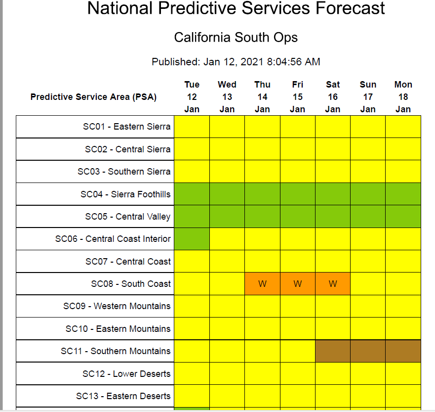
PS has just issued “High Risk” days for Thursday-Saturday for SoCal. A 2nd, potentially stronger, offshore is no looking likely for Monday-Tuesday of next week with more high risk days anticipated.
Could be an interesting staffing pattern with the mass layoffs the south just did. 
Good morning. Admins feel free to move this if this is the wrong spot to post this I’m curious to hear from some of the people who’ve been around for a while to see if these types of weather patterns are more “common” this time of year in SOPS? Are red flag events in January a sign of the times with a changing climate or is this not too outlandish to see in Southern California’s typically warm and dry climate? Thanks!
It is normal to have the threat of wind driven fire in the brush component for an extended period of time until fuel moistures surge up in Fed/Mar. Many times we don’t have to worry about it because there is wet weather to suppress the threat of wind. However, it is not “normal” to have this dry of winter. (That has been more common the last 10-20 years). Green up from our decent first storm in early Nov and the good one 3 weeks has caused a grass crop to start popping up in spots. It will especially sprout in the next few days with the unseasonably warm days and night. So hopefully that grass crop will help us out in some spots. The brush however is good to go when supported by wind.
Crest fire started Jan 28, 1984. when it went over us at 1130 PM, JPL clocked gust over 90mph. yes, with fuel conditions as they are, big fires can and have happened her in the South; some years never stopped having fires. Pray for rain
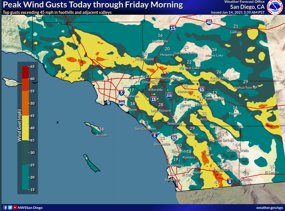
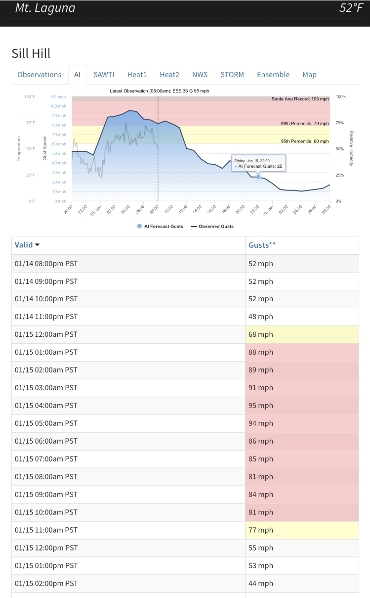
Some SoCal locations have experienced extreme wind gusts over 90 mph in the last 24 hours.
Forecast models are in decent agreement that an upper level low pressure system will amplify on the eastern side of the big ridge, and take the rare backdoor trek through the Mojave desert to offshore Southern CA Monday night. This is similar to the cloudy Santa Ana wind event of last month, which had a low pressure system take a similar track.
The GFS shows LAX-DAG (the east) gradients at -8 for more than 12 hours time, with a peak of about -6.6 from LAX-BLF (the north). Deep layered flow from the NE from 850 MB to 300 MB will be in alignment with offshore pressure gradients. Significant cold air advection will likely drive this deep layer of winds to the surface as a well established cold airmass is transported from the upper midwest. As the upper level low moves west of the mountains, precipitation may form in the deserts and eastern slopes in the form of snowfall… and the process of the precipitation moving over the mountains and evaporating may lead to Foehn enhanced winds with mountain wave activity.
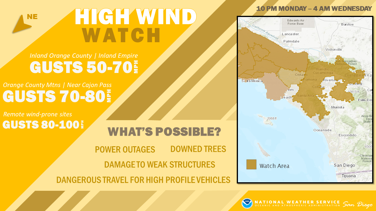
All of this leads to a damaging wind event where power outages are likely. Early forecast consensus supports high wind warning level winds of 30-40 MPH with gusts in the 50-70 mph range in the favored valleys, typical canyon and mountain locations that are favored for 40-50 MPH with gusts 65-85 MPH.
High resolution forecast models will be key in the exact strength of this rare scenario, and will be available tomorrow starting with the NAM.
And vacation can not come soon enough…
Stay hydrated my friends.
latest Live Fuel Moisture readings:
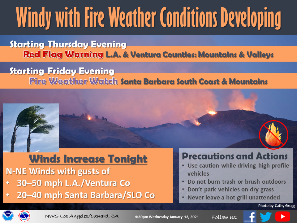
From NWS LOX
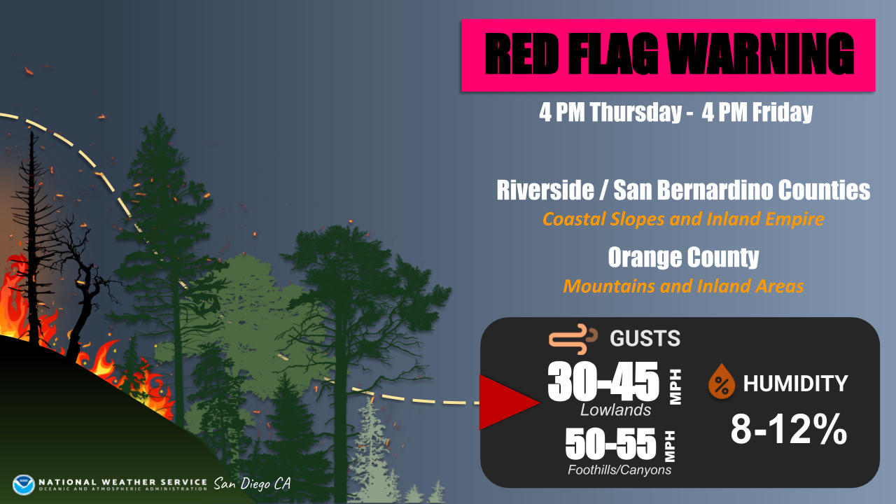
HAZARD DETAILS
Southwest California - Moderate-High CONFIDENCE in Wind and Minimum RH. Lower confidence in timing (event ending)
Fire Danger
Tonight-Sat or Sun Impacts include:
· Rapid spread and extreme fire behavior with any new fire start
· Brief critical fire weather conditions for southern Santa Barbara County
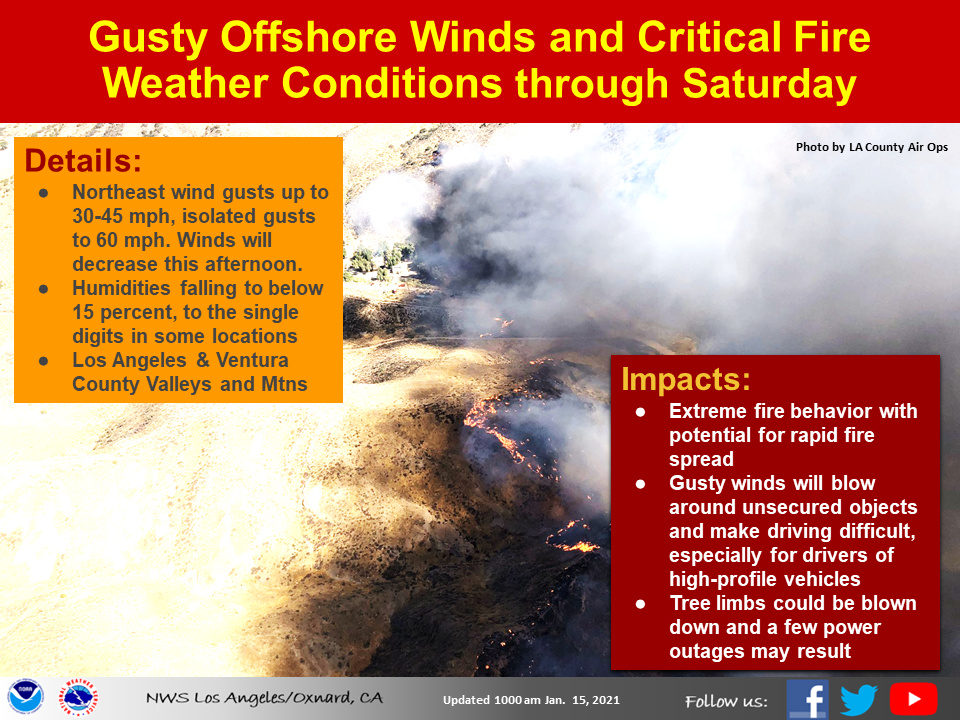
Details What: Gusty Santa Ana winds will continue through Saturday afternoon. Northeast winds 25-35 mph with gusts to 50 mph likely, local gusts to 60 mph in the mountains. Winds will diminish tonight but increase again on Saturday. Minimum RH 8-15% with isolated down to 5%. Poor overnight recoveries. Red Flag Warnings in effect through 4pm Saturday.
Where: LA/Ventura County valleys and mountains (except San Gabriel and Antelope Valleys). 3-4 hrs of critical conditions Santa Barbara County south coast tonight mainly above Montecito.
When: Through Saturday afternoon. May need to extend the red flag into Sunday.
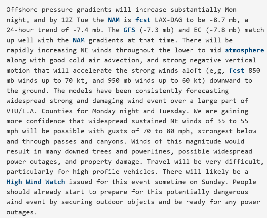
From this mornings Forecast Discussion from NWS LOXhttps://www.wrh.noaa.gov/total_forecast/getprod.php?afos=afdlox&wfo=lox&new :
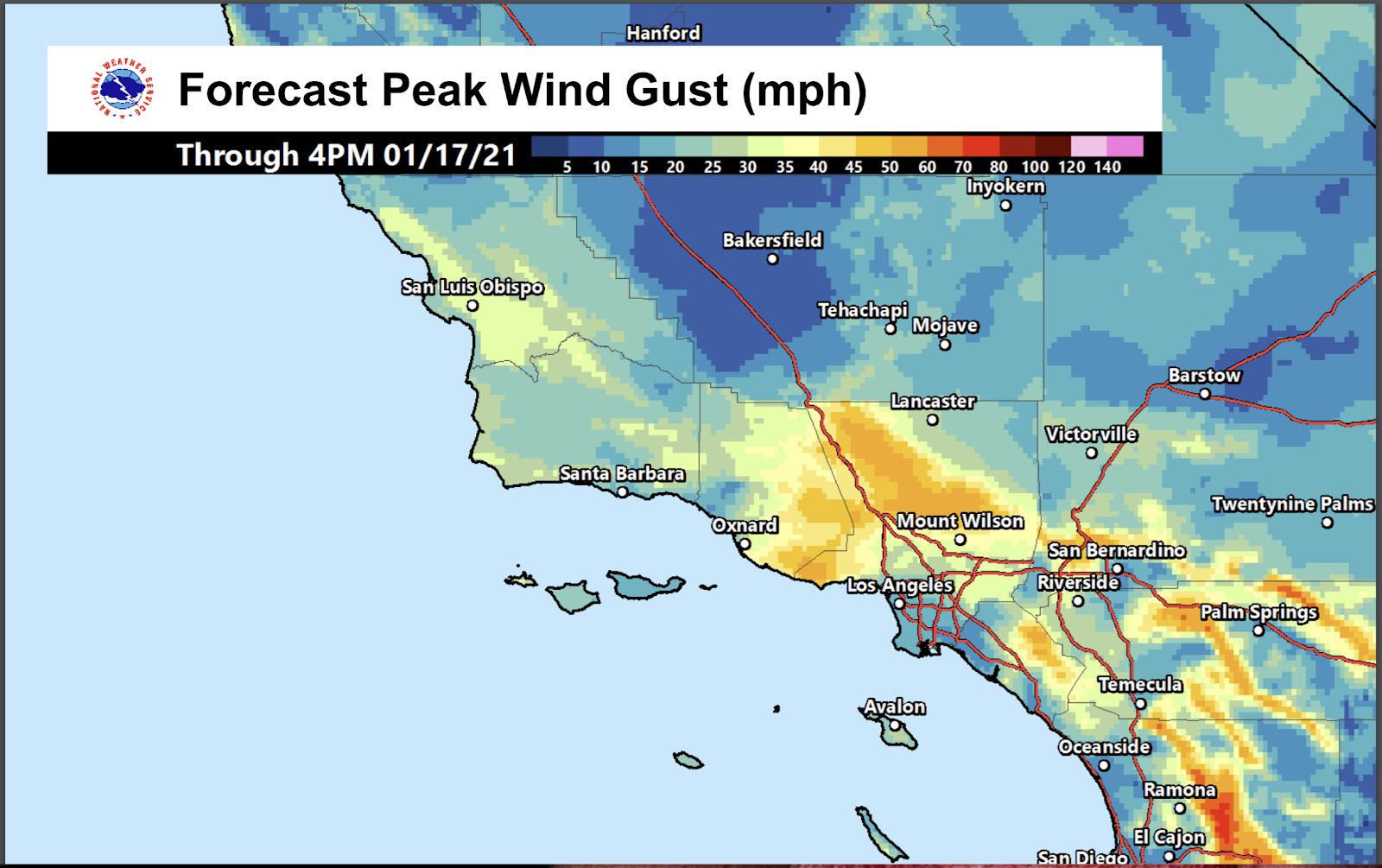
Several of the EC members are indicating peak wind gusts over 75 mph in the Santa Clarita and San Fernando Valleys Tue. Needless to say, this has the potential to be a very serious and damaging wind event, likely beginning late Monday or Monday night, peaking Tuesday into Tuesday night, and winding down on Wed. Wind gusts of 80 to 90 mph or even higher are possible in the windiest locations during the peak of this event. This is definitely the type of event that could bring strong northeast winds to the coastal waters and to Catalina Island and the northeast facing harbors of Avalon and Two Harbors.
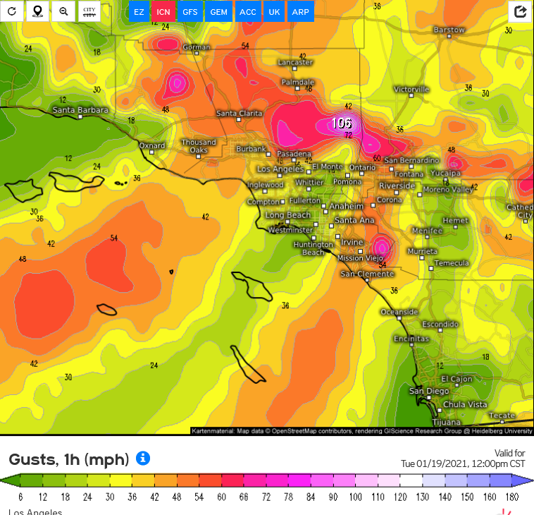
Damaging wind event for Monday night into Tuesday.
Pressure gradient peaks:
LAX-DAG: -8.2
LAX-BLF: -5.5
Upper level support: strong
Cold air advection: strong
Relative Humidity: 20-25%
Expected winds: widespread 30-40 MPH with gusts to 60 MPH.
Santa Ana favored 35-50 MPH with gusts to 75 MPH.
Mountains favored 45-60 MPH with gusts up to 90 MPH, locally 100 MPH.
Only a moderate chance of large fire activity due to the higher humidity and isolated showers/snow in the mountains, but isolated locations out of the moisture shield could see extreme fire behavior on any new starts.
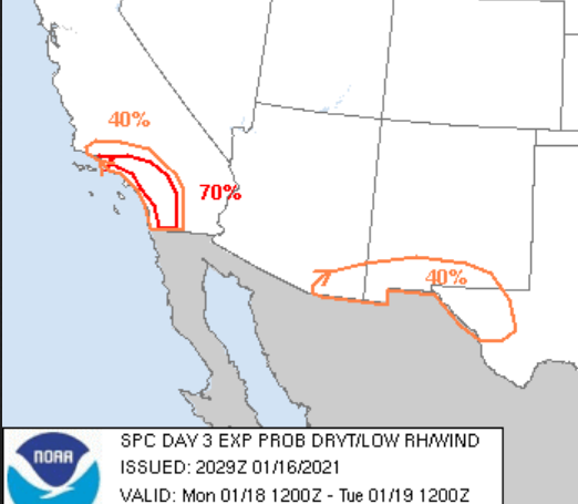
The storm prediction center will be issuing critical delineations despite South Ops not adding high risk days.
On a scale of maximum potential Santa Ana wind events possible for Southern CA I would rate this an 8.5/10.
Confidence on a scale of 1-10: 7
Now from NWS Los Angeles which matches well with my assessment: