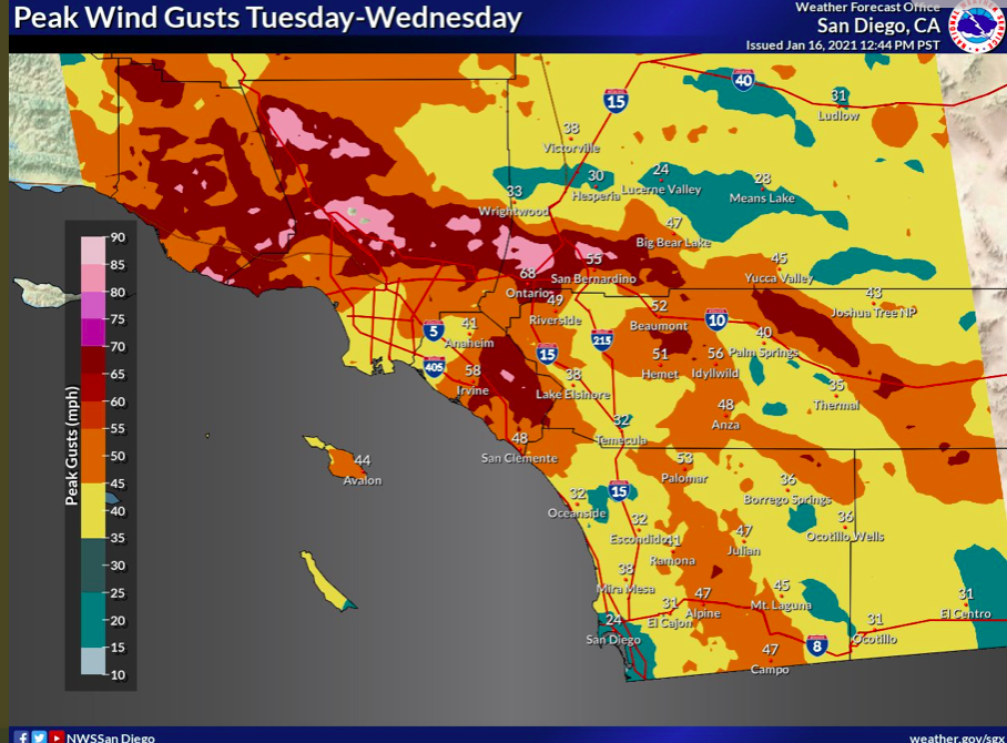
To tag on above, here are the projected wind speeds from NWS San Diego. But the caveat remains that humidity will be higher and some wrap around moisture and showers may be produced. So fire threat may not be as high but damaging wind impacts will be high. Downed trees, power outages, and blowing debris.
5 Likes
I don’t see how this is possible and seems extremely overdone to me…NWS doesn’t even have a wind advisory anywhere in MVU. Fake news???
5 Likes
I believe the NWS is under playing the wind conditions in SD county, depends where the low goes, it is trending further west, so dry and could enhance winds in SD.Time will tell…
4 Likes

For the ones who do not know what the “D” stands for, anyone out there who can explain it in layman’s terms…
1 Like
I believe it stands for “Day”
1 Like
That is correct.
1 Like
High Wind Warning
URGENT - WEATHER MESSAGE
National Weather Service SAN DIEGO CA
152 PM PST Mon Jan 18 2021
CAZ043-050-058-190600-
/O.CON.KSGX.HW.W.0001.210119T1500Z-210121T0600Z/
San Diego County Coastal Areas-San Diego County Valleys-
San Diego County Mountains-
Including the cities of Vista, Carlsbad, Encinitas, Chula Vista,
National City, San Diego, Escondido, El Cajon, San Marcos,
La Mesa, Santee, Poway, Julian, and Pine Valley
152 PM PST Mon Jan 18 2021
…HIGH WIND WARNING REMAINS IN EFFECT FROM 7 AM TUESDAY TO 10 PM
PST WEDNESDAY…
-
WHAT…East winds 25 to 35 mph with gusts to 60 mph expected.
Gusts over 70 mph possible in wind-prone passes and canyons. -
WHERE…San Diego County Coastal Areas, San Diego County
Valleys and San Diego County Mountains. -
WHEN…From 7 AM Tuesday to 10 PM PST Wednesday.
-
IMPACTS…Damaging winds will blow down trees and power lines.
Power outages are possible. Travel will be difficult,
especially for high profile vehicles. -
ADDITIONAL DETAILS…Highest gusts expected Tuesday night then
again Wednesday late afternoon and evening. Please report any
severe damage to NWS San Diego.
PRECAUTIONARY/PREPAREDNESS ACTIONS…
People should avoid being outside in forested areas and around
trees and branches. If possible, remain in the lower levels of
your home during the windstorm, and avoid windows. Use caution if
you must drive.
5 Likes
Mammoth mountain summit has reached 113 mph gusts.
https://www.wrh.noaa.gov/mesowest/timeseries.php?sid=MTH03&num=72&banner=gmap&raw=0&w=325
4 Likes
I remember the days when the winds were strong enough to blow the fire out. Hoping this happens if we get a start on the IE part of So Cal.
3 Likes
Apparently the wind gauge at cascadel heights a bit east of north fork 110 mph!
https://www.wrh.noaa.gov/total_forecast/getprod.php?new&prod=XXXAFDHNX&wfo=hnx
4 Likes
MOUNT ELIZABETH (noaa.gov)
Power flickering and hear trees falling…wouldn’t want to be driving or walking in the timber right now.
MOUNT ELIZABETH (noaa.gov)
Have not had wind like this in a long time.
4 Likes
Buckle up So Cal.
4 Likes
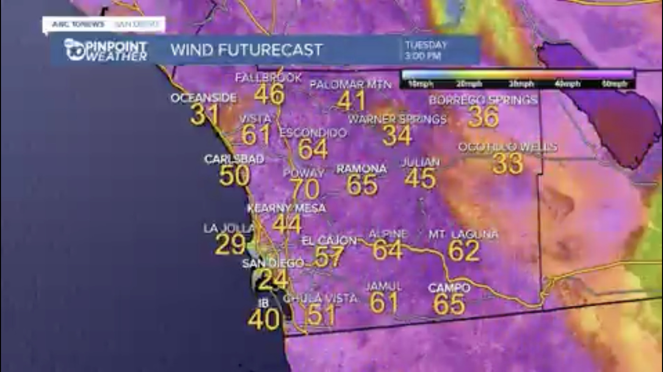
Slow start to the event. The low moved down and spun up marine layer in the LA Basin. NWS stating that the atmosphere is de-coupled and the winds are happening above 3700 feet. As the morning progresses the winds will drop into the valleys. Winds in the passes and canyons just now starting to trend from the NE. Porter Ranch in the San Fernando Valley is ratcheting up and has sustained winds at 27 and G of 48.
6 Likes
Warm Springs - 12:53 PM Winds: ENE 61 G 88 mph RH 22%
6 Likes
A trough of low pressure is phasing into South Ops, bringing low elevation snow and rain showers this weekend. An extremely cold trough is going to move south behind the first one on Monday, bringing some of the coldest air in many years.
NWS continues to take the correct, conservative approach to snow levels at this time with 2,500 ft being reasonable. However, if the NAM and GFS solutions do verify it is a fair assessment to say snow could fall as low as 1,000’ Monday night into Tuesday.
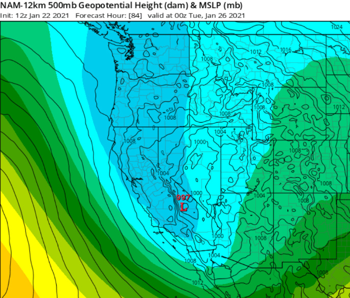
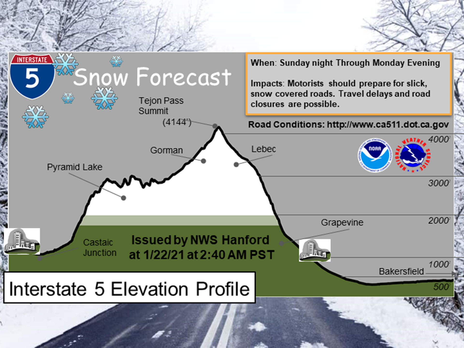
From NWS Hanford:
Another trough will phase into the area Wednesday, potentially bringing heavier precipitation. At this time, it would appear that fire season is over for South Ops.
7 Likes
Fire season 20 finally done. Keep the rain coming, we all need a some time to rest.
4 Likes
New wind events coming this weekend in SoCal. Santa Ana’s in the usual places plus unusual foothill wind event in the SGV possible.

Issued: 1130am Friday, Feb. 26, 2021
Point of Contact: NWS Operations
KEY POINTS
· Increasing risk of gusty North winds for the San Gabriel Valley foothill and nearby valley communities early Sunday morning, Feb. 28th
· Expected to be weaker than Dec. 2011 damaging event, but still potential for wind impacts
SUMMARY
Low pressure will rapidly deepen just south of Nevada early Sunday morning (attached graphic) and will align winds from the north over Los Angeles County. This weather pattern is extremely rare and difficult to predict exactly where or if winds will surface into foothill and valley locations. Plenty of uncertainty exists, but there is a potential for a short period (1-3 hours) of north wind gusts into non-typical areas of the San Gabriel Valley between 4am to 10am Sunday morning.
Locations possibly impacted include,
La Canada Flintridge, Altadena, Pasadena, Temple City, Arcadia, Azusa, Monrovia, Duarte, Glendora, and San Dimas.
HAZARD DETAILS
San Gabriel Valley areas - MODERATE Confidence in winds, LOW Confidence in wind strength
Gusty
North Winds
Early Sunday Rare North winds over the San Gabriel Valley foothill and nearby valley areas
· Potential for downed trees and power outages
· Potential damage to outdoor temporary structures, tents, and loose items
· Elevated to brief critical fire weather conditions
Details - What: A brief period of unusually gusty north winds 40 to 50 mph is possible. Uncertainty in the track of the system means that wind gusts could be plus or minus 15 mph of that range. Meanwhile, humidities will start fairly high but lower into the 5 to 15% range by Sunday afternoon leading to elevated to brief critical fire weather conditions.
- When: 4am to 10am Sunday, Feb. 28 (peak gusts lasting 1-3 hours)
- Where: San Gabriel Valley foothill and nearby valley communities

Mid-level low pressure (above) centered over west Arizona at 7am Sunday, Feb. 28. Warmer colors are associated with higher winds aloft (~20,000 ft) which typically enhance north winds at the surface.
4 Likes
Mono winds are moving through the san joaquin river gorge tonight! North fork raws is up to 41 mph gusts, Corrine lake hit 51, redinger lake hit 50.
Mammoth mountain hit 131mph and had sustained winds over 110mph.
https://www.wrh.noaa.gov/mesowest/timeseries.php?sid=MTH03&num=72&banner=gmap&raw=0&w=325
3 Likes