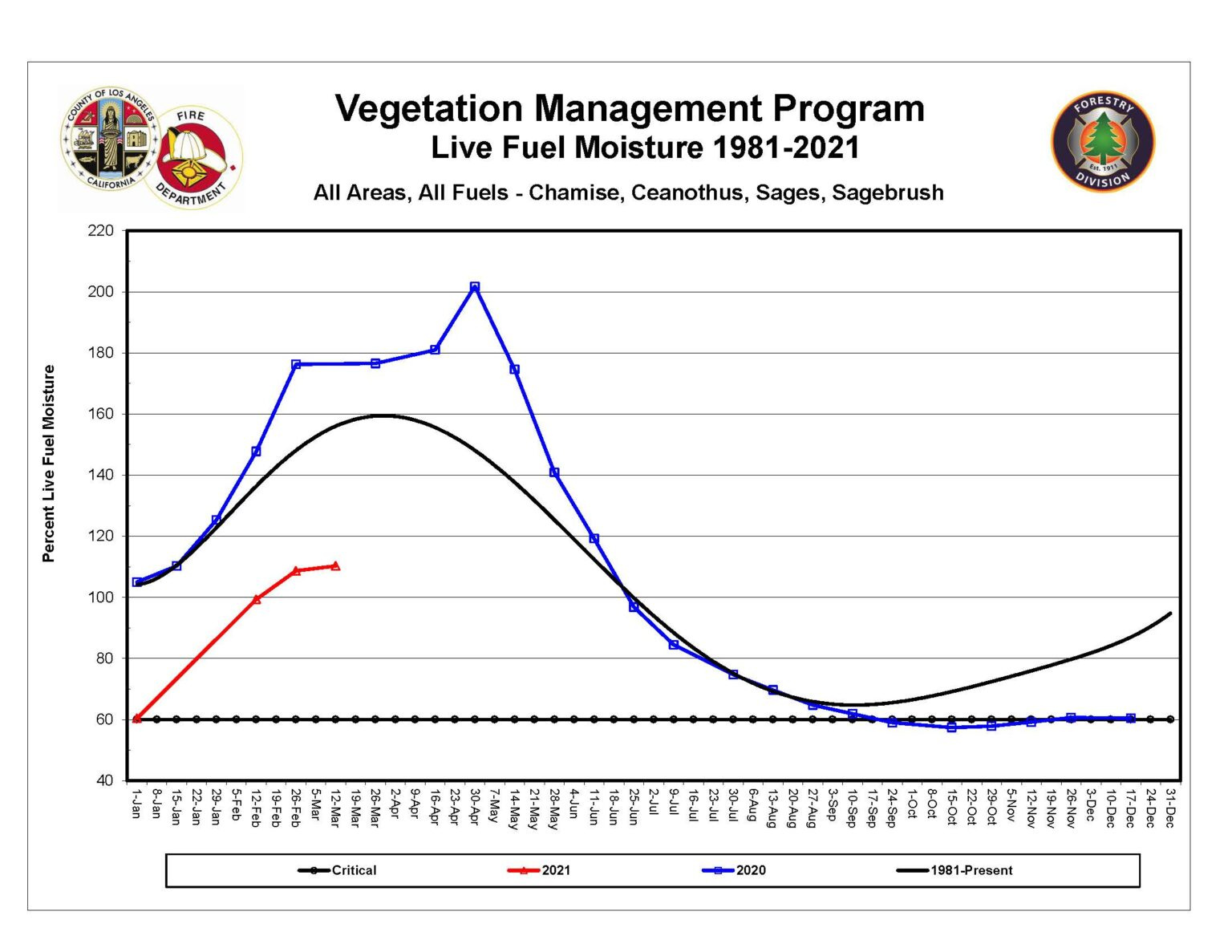
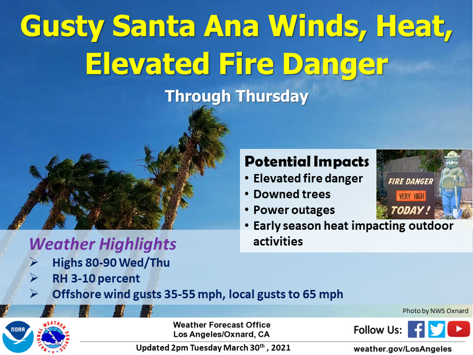
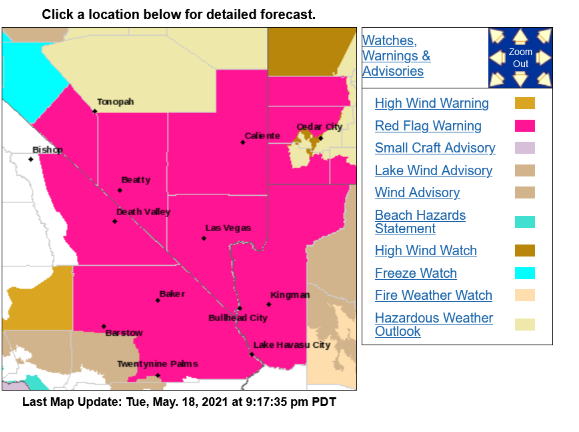
Elevated convection possible Thursday with dry lightning strikes. Live fuel moisture continues to struggle across much of Southern CA. The late March heatwave, Santa Ana winds, and very small grass crop already curing will lead to locally receptive fuel beds during the afternoon.
Are season creeks in the motherlode look pretty wimpy right now. New Melones Res for this time of year not looking the greatest. We are catching bass in about 30’ of water. Hopefully enough snow melt to bring our reservoirs near capacity. 23 acres between Buck Meadows and Groveland last Sunday. Upper 60’s and 70’s rest of the week in Twain Harte.
Thanks for sharing…I live between the Stanislaus and Tuolumne River Basins and it’s been looking terrible. Fished Melones last week and the south fork of the Stanislaus was a trickle for this time of the year coming into the lake. Two feeder creeks that flow into the lake which are Mormon and Coyote Creeks look dismal the amount of water coming in. We did manage to get an inch of rain from the last storm over the weekend. Lot of Digger Pines looking like hell right now turning brown. This is not a good sign for things to come.
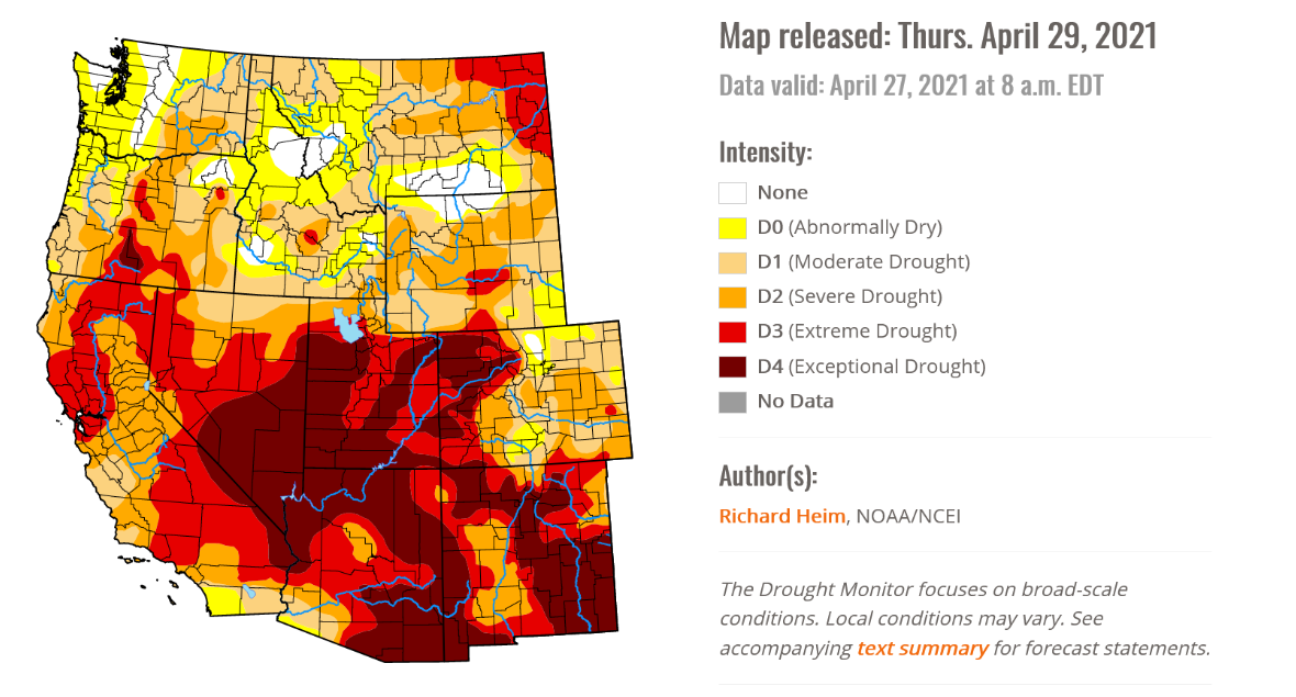
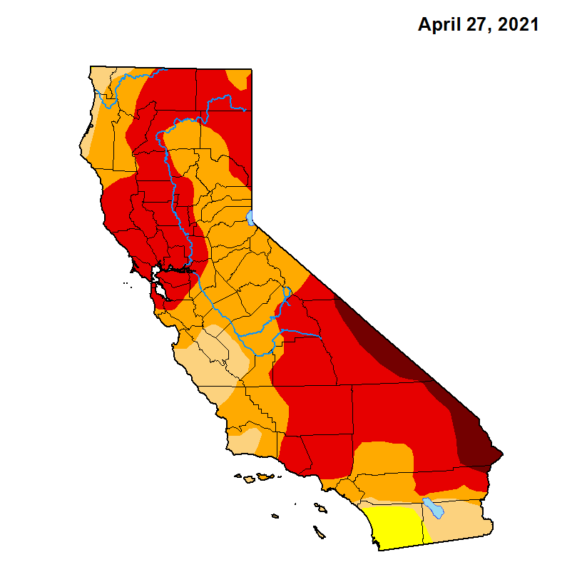
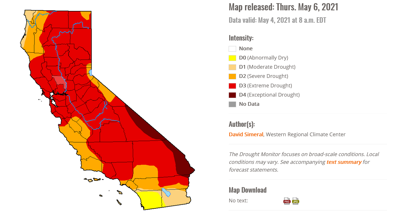
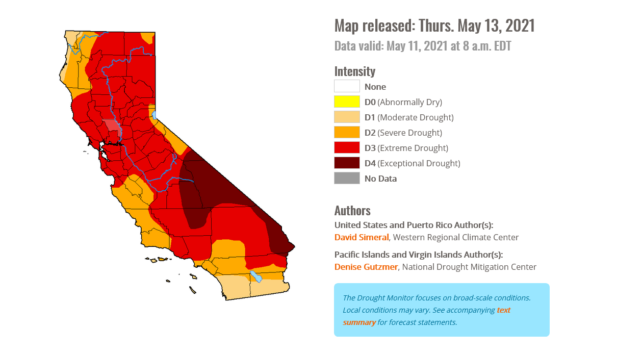
Severe to extreme drought across South Ops will continue to worsen through the spring time as dry conditions persist. Fuel moisture levels are running below average across most of the operational area. Grass and brush fires will continue to ramp up with large fire activity occurring 3-4 weeks ahead of normal. A smaller grass crop due to lack of precipitation could lead to a shorter window for grass fire season as the small grass crop decays earlier in the season. Modoki La Nina over the eastern pacific should promote a higher chance of monsoonal moisture influxes from the south this year, with the possibility of an early monsoon. However, extreme drought across the desert SW will limit the amount of low level moisture available. The Southern Sierra Nevada is reporting 11% snowpack or 14% of normal for this time of year. South ops major reservoirs apart of the aqueduct system are running an average of 72% of normal for this time of year, however with virtually no snow pack available there is a major threat for this number to drop to critical levels.
High pressure continues to build across South Ops with weak offshore flow at the surface. The winds are gradient and subsidence driven as upper level support has dropped off from yesterday. The anomalous upper level high pressure is causing near record heat across Southern CA along with RH in the 8-15% range. This is causing further drying of fuels through Saturday. Cooling begins this weekend as an inside slider deepens the marine layer and promotes strong NW flow across South Ops. The widespread deeper marine layer is short lived as the inside slider moves away and ridging builds back over the area into the middle of next week.
The highly amplified, see-saw pattern that has been occurring since last spring that brings cooler weather followed by much above average temperatures is continuing. This pattern promoted strong NW flow followed by drying offshore flow, which reduced the amount of marine layer coverage and days it was present plus dried fuels out. This is continuing through at least the middle part of May.
Long term…
Sea surface temperatures off of the Southern CA coast continue to be below average, whereas the Western and Northern Pacific continues to be above average. The increased SST in the West and North Pacific could promote stronger tropical cyclone activity and a robust jet stream in the N pacific this summer as a result. This could lead to an extremely chaotic weather pattern across the US, with increased tropical cyclone activity across the southern US, high pressure across the central plains, and severe weather across the northern US. The modoki La Nina could lead to stronger high pressure across the 4 corners region, allowing for increased chances for monsoonal moisture. We are overdue for an active season. Due to extreme drought across the SW, the beginning of the monsoon season could start off very dry.
It is too early to predict past 3 months regarding offshore wind season.
Their opinion is different in that the cooler SST off CA and Gulf of Alaska should lead to troughing and a deeper marine layer in May and June with normal large fire potential.
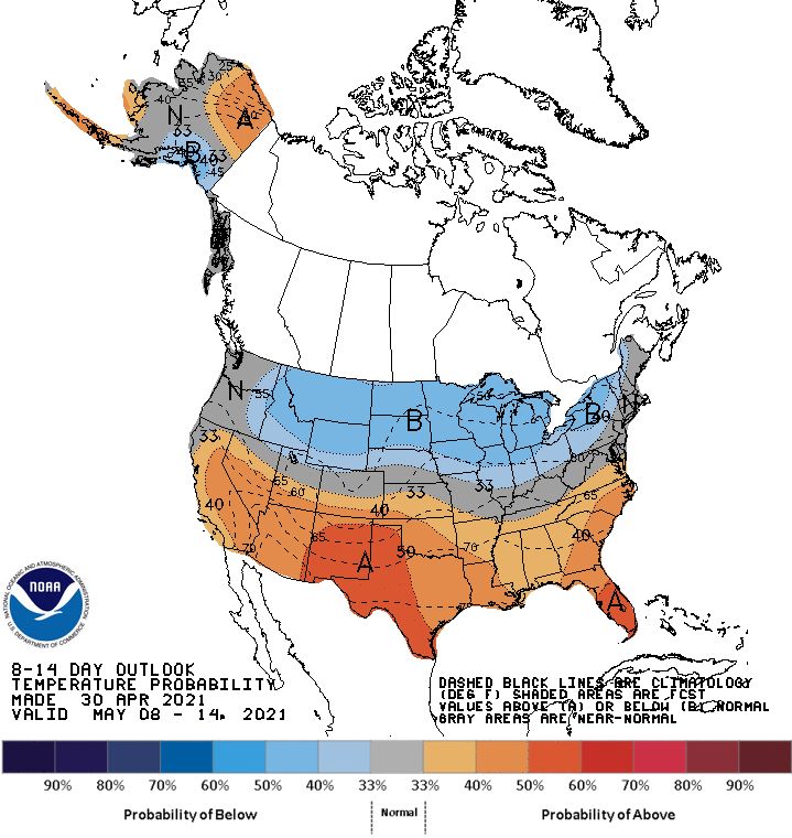
My opinion is different in that I think the extremely amplified pattern across the north should promote large temperatures swings and potential for offshore flow as more amplified high pressure builds in the wake of the more amplified low pressure troughs to the north, ultimately increasing the chance of heatwaves. The climate prediction center supports the idea of warmer than normal average temperatures across South Ops in the 8-14 day range
Forecast models are in agreement that transient ridging will move over the area through Thursday. Temperatures will be 5-10 degrees above normal with light offshore flow in the morning.
On Friday night a cut off low pressure system develops and moves down the breadbasket of CA. The exact track remains in question. If it takes a more over water track there could be some precipitation from a deepening marine layer on coastal slopes and convection in the mountains. An inside track could lead to a bit drier solution. Temperatures will knock down below average for the weekend.
This is not expected to be a major precipitation generating event. Weak troughing may linger into early week with a return to stronger ridging mid to late next week.
Catastrophic water deficit continues.
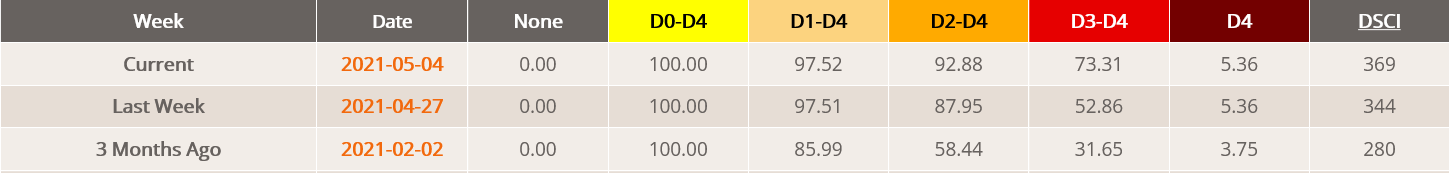
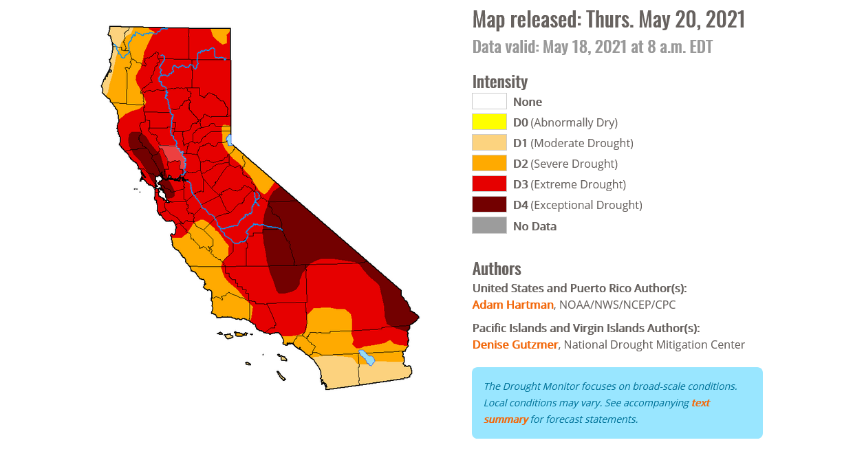
Exceptional drought increases to 13.53% of the state from 5.36% last week, now including the entire southern Sierra Nevada.
Transient ridging builds through Thursday and temperatures will bump up every day. A trough of low pressure drops into the Tahoe Basin on Friday according to all ensemble means and this drops temperatures, increases onshore winds, and deepens marine layer.
Fire danger should increase on desert slopes.
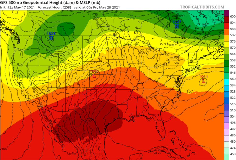
The low pressure system spins down and heights increase across the area. Early next week, zonal flow should begin to develop across the area which is the norm for late May and early June… however it looks like temperatures are going to be above normal due to a very strong subtropical ridge building across northern Mexico/Texas region.
GFS consistently builds in a very strong ridge into N Mexico/Texas next week
The amplified pattern continues, and if the strength of this early season ridge comes to fruition it’s a very grim sign for us as the subtropical ridge migrates north during June and July.
Chance of thunderstorms today across much of the area. Mountains and deserts greatest chance. With the wind situation any lightning outside of rain cores could be an issue.