LAC County Live Fuel Moisture
:
On 4/26/23 the Nob Fire burned 226 ac. with a rapid rate of spread; mostly terrain driven.
just S/SE of Wrightwood, we had 47 inches of rain and 8 feet of snow in Wrightwood…still this fire ran to the Ridge…pink snow assisted crews in containing it.
just a heads up; LFM does not tell the whole story, dead fuel carryover is still a factor
be safe out there
NE aspect as well…i think it surprised us all.
I did not see the fuel moisture around the time of the fire, does anyone think the live fuels were still dormant when that fire occurred?
The live fuels were absolutely still dormant. The fuels up in the Wrightwood area are just now starting to bud.
The Nob fire was in the Old-Grand Prix scar from 2003. That’s a 19yr old fuel bed. The brush in CA has a 14-18yr lifespan. Betting there was a heavy dead component to the fuel bed. That with dormant LFM and That’s what we get.
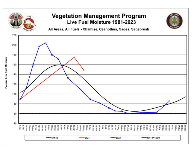
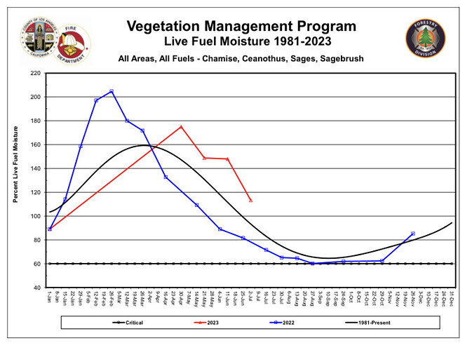
Seems odd that they started at higher values in 2022?
Does anyone collect live fuel and share it publicly from that area? Just curios what they were at.
San Bernardino County Fire reported a 60-100% dead fuel component inside the brush canopy.
We collect Yuciapa Ridge at the 3,000’ elevation
5/23/23
New 117.215 (down 29.87%)
Old 89.467 (down 18.85%)
Avg 103.341 (down 24.351%)
Fuel moisture peaked around April 2 at approx 160
It’s because they did not sample the vegetation since January 1st, so the data is missing
A permanent marine layer has been established as we head into the ice age.
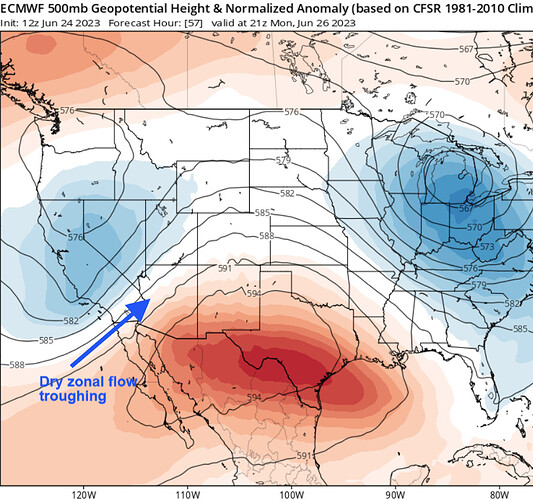
Kidding aside, warming temperatures and high pressure should shrink the marine layer through the end of the week, followed by a truly impressive trough entering the Pacific NW around Fathers day. This trough is well modeled on ensembles and will increase onshore winds significantly for elevated large fire potential in dry fuel beds on the desert slopes. Expect increased initial attack on the long holiday weekend, with the possibility for large fires due to wind on desert slopes.
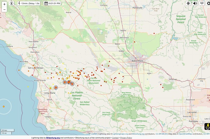
The enhanced suptropical jet stream has kept us under cooler than average temperatures, but it has also obliterated the SW monsoon. Zonal flow off of the ocean has kept the monsoon away across Arizona, CA, and NV. The center of a high pressure system is set to establish itself next week into early July across Northern Mexico. The descending motion of a high pressure system in this location will continue to keep moisture advection away from CA and AZ and keep dry zonal flow undercutting the ridge. If the high pressure stays in this area for the season, moisture will eventually become entrenched into the middle and upper layers, but the broad based zonal flow and descending motion could lead to shallow convection and very dry low level moistures, plus the added shortwave potential off of the Pacific could lead to more nocturnal lightning bursts than normal.
Early next month the Western trough finally moves into the midwest, and our weather could be dominated by the North Pacific ridge as surface high pressure builds into the Great Basin. This is a pattern that is seen in the fall time… and would keep the monsoon away through at least July 7th.
The full transition to a summer-four corners high could be delayed until mid to late July.
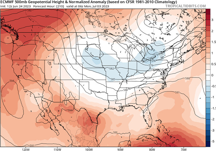
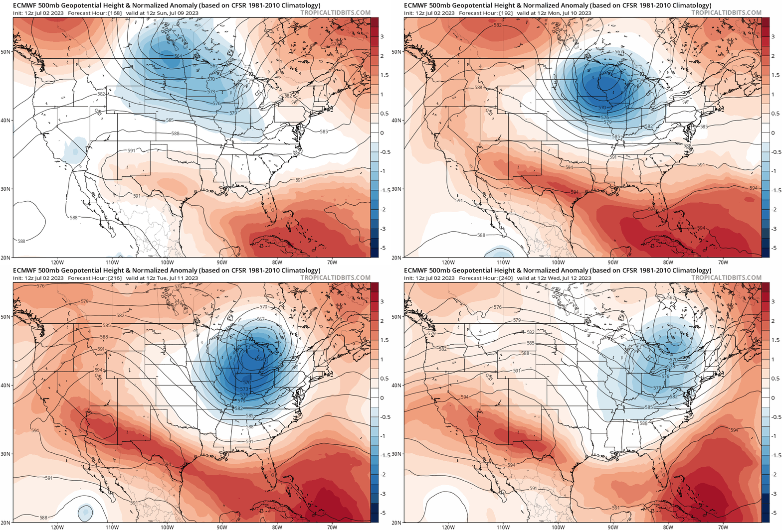
Update… increased confidence for a major heatwave for California for the first week of July as the ECMWF deterministic show 500 mb height anomalies.
Although this is still approximately 9 days out, due to the run to run consistency and climatology plus the existing weather pattern it is highly likely we are in for a major heatwave around July 11th-July 15th.
The ECMWF deterministic model continues a blocking pattern across Western Canada through the extended term which favors a deep Midwest trough, and thus subsequent high pressure amplification over the SW US.
The GFS deterministic model takes the troughing a bit further east before retrograding it into the SE, which delays the heatwave 48 hours, but the ECMWF is the favored model for long range forecasting.
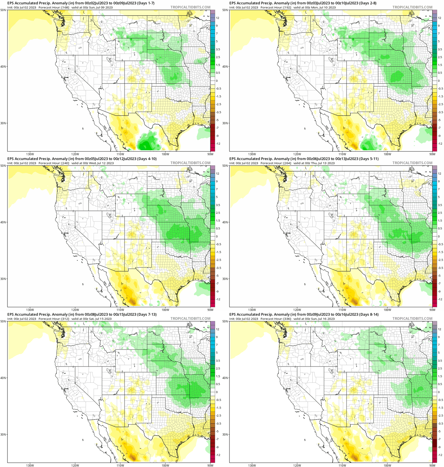
The expanding ridge should bring shallow monsoon moisture to the region by the middle of the month, however it is likely to be limited to the middle and upper layers of the atmosphere as there is huge deficiency in available moisture over Arizona, and Northern Mexico due to the record dry monsoon season thus far.
The large fire threat continues to increase across elevations below 3,000’ away from the coastal areas as the fuels dry. Even though it has been cooler than normal, it is a drier air and a lot of the excess moisture from above average rainy season has mixed out. So expect a larger potential for heavier fuels to become receptive at the same time as the heavier than normal grass crop because the heavier fuels tend to have a biological clock that causes dormancy irregardless of weather.
