Crossing fingers for a more moderate event.
But am I wrong in observing that this event saw more erratic wind directions on the lee sides and typically non-wind prone areas? I wont pretend to understand Mountain Waves fully. But with Thurs-Fri’s flow, can the wind corridors of LA and VTA counties expect more consistent wind direction?
It seems like just a month ago the Franklin Fire was staying pretty corralled by the wind direction. These ones are just seeming to be getting pushed everywhere
3 Likes
HWW and RFW extended a full 2 says for SDU per NWS San Diego office. Both run until Friday afternoon/evening now.
4 Likes
From NWS partner email:
Greetings Partners,
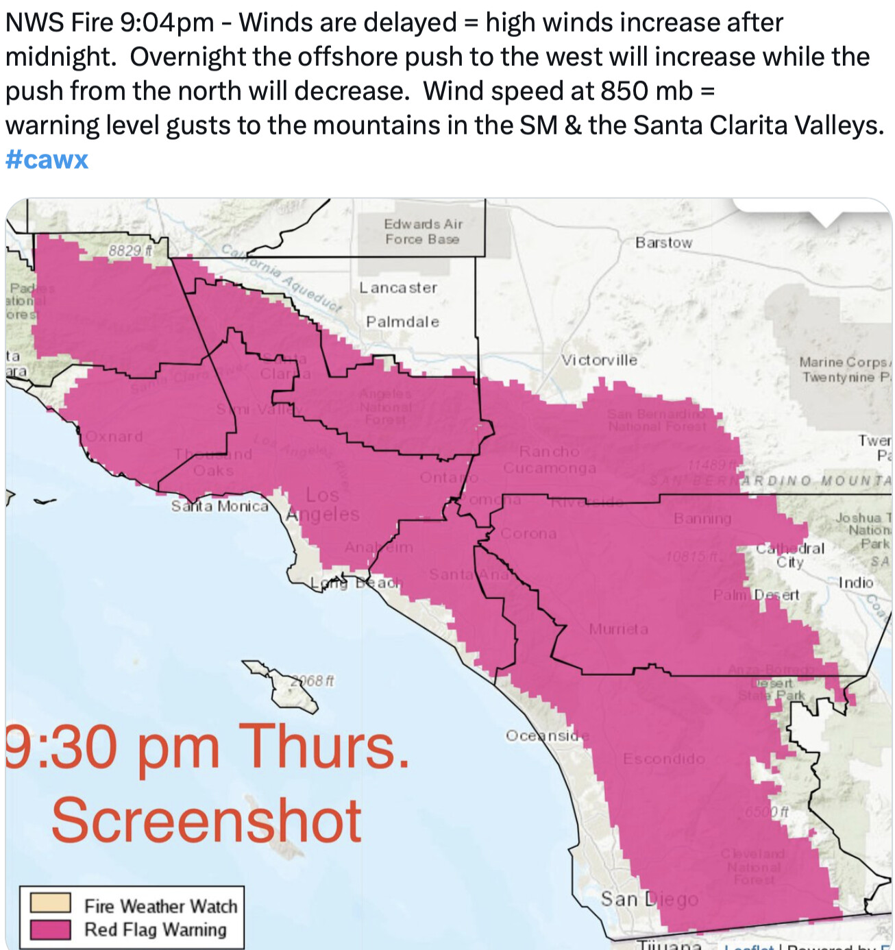
We are well underway with this extreme fire weather and windstorm event. Winds have trended downwards, with gusty conditions mostly confined to the mountains, foothills, and valleys of LA and Ventura Counties (and Malibu Coast).
- Northeast winds in these areas at 15-30 mph sustained with gusts of 35-55 mph through tonight.
- Thursday afternoon winds will bump back up along the Santa Ana Wind prone corridor, with northeast gusts 30-40 mph (mountains/foothills 50-60 mph, isolated gusts to 70 mph). Peaking Thursday evening into early Friday morning.
- Some onshore flow may return tomorrow near the coast for the Palisades Fire, which may alter the fire spread direction and increase smoke for nearby areas.
- Around south-facing foothills, winds are likely to be more erratic – which may lead to chaotic fire growth.
- Widespread humidities in the low-to-mid teens are currently common today, and will continue to trend downward, with single digit humidities possible into Friday.
With lower winds, the PDS tagline of the Red Flag Warning will drop off at 4 pm today. Regular Red Flag Warnings extended through Friday afternoon for portions of Los Angeles and Ventura Counties. Even as fire weather conditions improve somewhat tonight, we encourage residents to remain alert to the forecast and local officials, and make evacuation plans now!
The outlook for early next week favors weak-to-moderate offshore winds, with a 40-50% chance of a moderate-to-strong Santa Ana Event Monday into Tuesday.
5 Likes
I know the high wind warning/red flag warning for the Inland Empire and San Diego county is not a PDS warning, but it should probably be treated as such. Humidity values should be really low Into the single digits. The only thing is the duration is pretty short… However, there should be more offshore flow starting Monday, so any new starts can become campaign fires.
7 Likes
Not the time or place i get it but…
At some point can someone come on here and quantify the effectiveness, impacts on civilian behavior & how does the layperson tell/feel a difference between a PDS-RFW & “Normal” RFW? Asking for a friend…
4 Likes
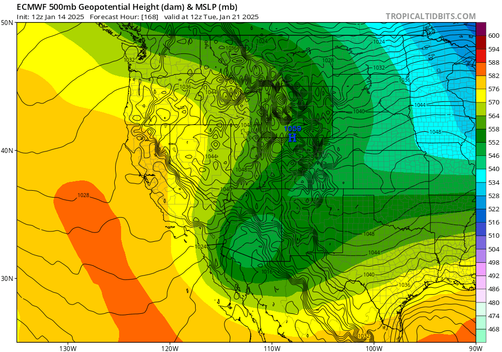
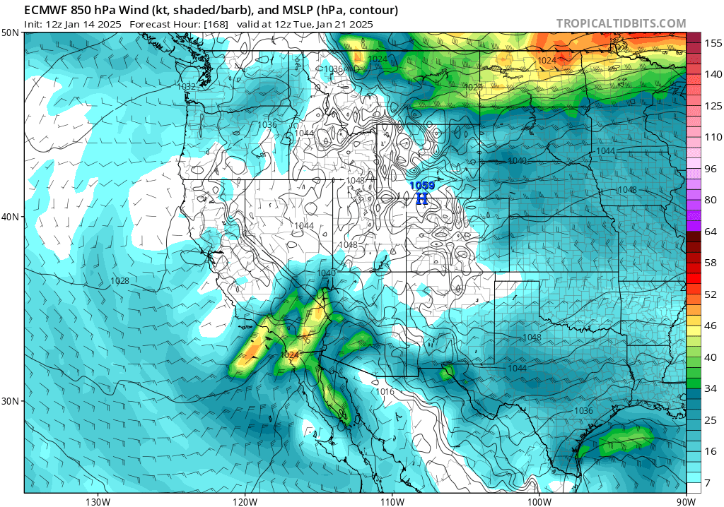
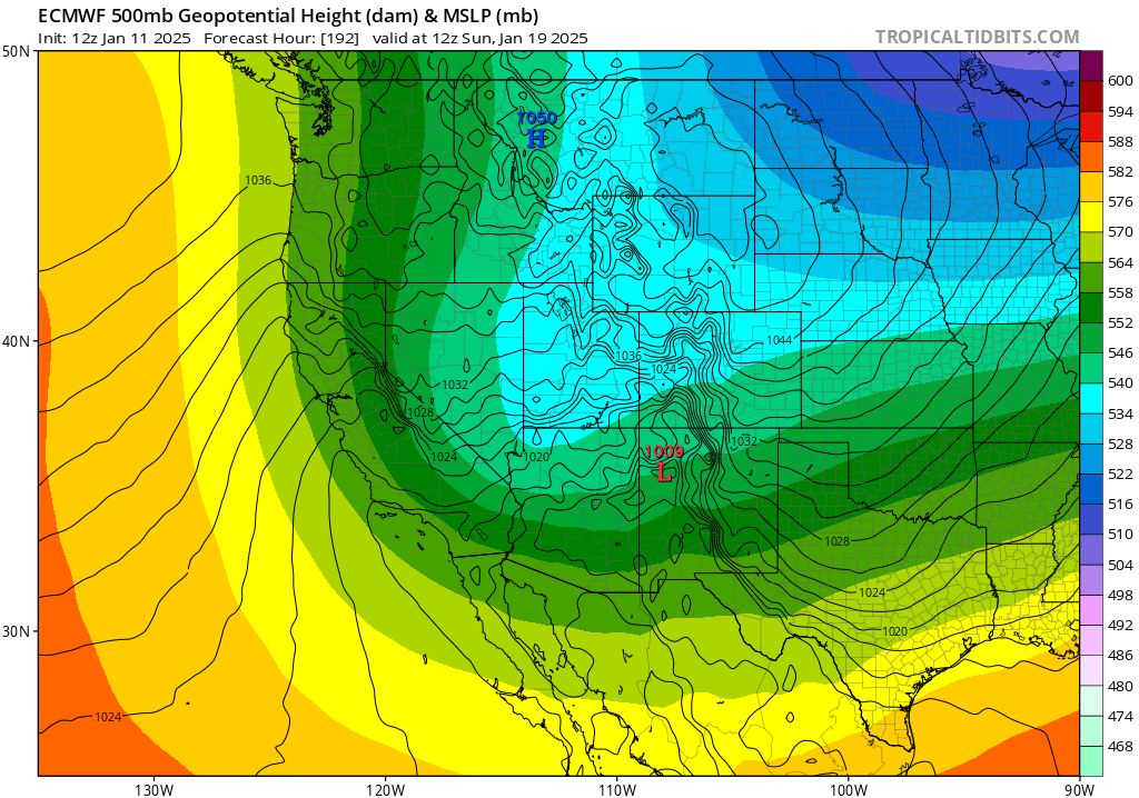
Forecast models bring a strong sundowner style wind event to eastern Santa Barbara County and Ventura County Monday night. This wind event would transition into a Santa Ana Wind event a few hours after onset. The upper level low is rotating around a much larger trough and is going to be directly overhead, the humidity values should remain above critical levels during the initial onset of northerly winds. This set up is different as this upper level low becomes an outside slider off the coast, cutting off from the main flow. The low pressure system is deepening at the same time which could keep offshore flow persistent and cold air advection from the great basin going. This could bring unusual peaks of offshore winds while the low remains to the southwest. Cut off lows are very difficult to forecast.
It will be interesting to see what happens with this cut off low as it could merge with the prevailing flow… either bringing us precipitation, or inviting another very powerful wind event.
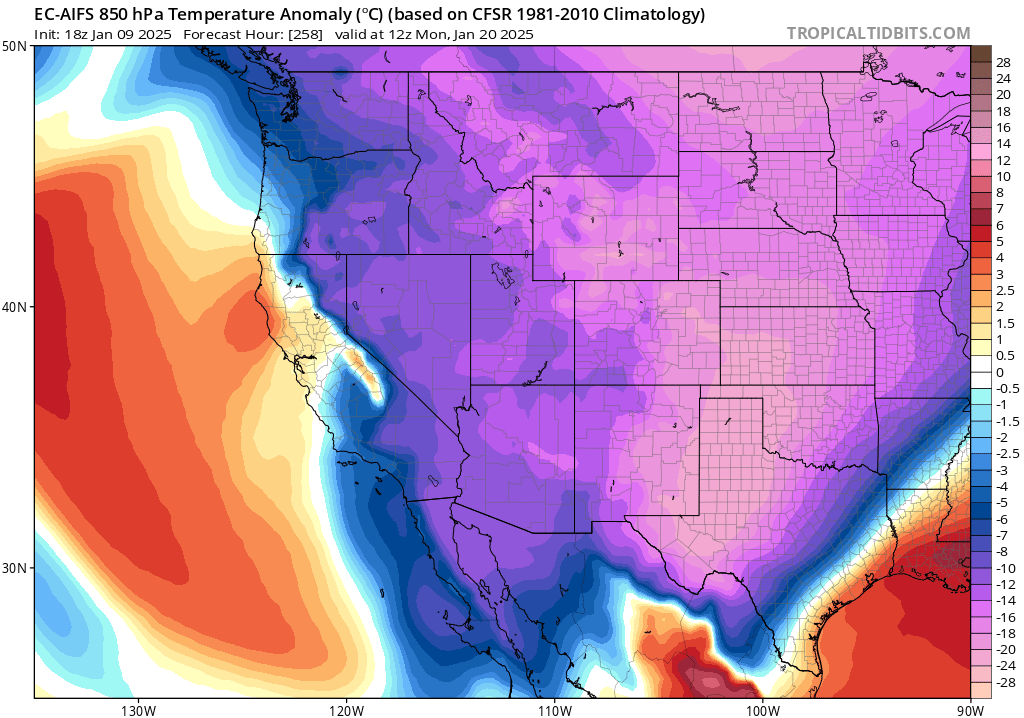
The AI European model is suggesting an even colder air mass entering the Great Basin around 1/18. This is too far out to forecast right now but should be monitored as it would potentially bring a maximum strength wind event, with a little bit of modeling adjustment.
18 Likes
Would you anticipate this wind event be more of a mass-scale but possibly moderate santa ana wind event or similar to what Los Angeles experienced last Tuesday?
2 Likes
Right. What type of winds we talking.
2 Likes
It’s still too early to tell. It looks like more of a ‘bulk’ situation rather than a focused jet streak right over LA County like the last wind event. The modeling will change the timing because the models rush cold air masses. How much upper level support will become clear as the resolution and data points improves with time. I’d bet on this being similar to an 11/8/2018 type event. Diablo winds then Santa Ana’s. We will see…
13 Likes
4 Likes
Tried uploading an image but getting error message on the website.
2 Likes
I’m having the same issue.
3 Likes
All-
The Mods are aware and looking into it. Most likely something above our pay grade and will need to be fixed by the site Tech Folks. Please be patient while a solution is figured out. Thank You.
Six
8 Likes
Yeah hoping its the same fix as last time -
3 Likes
Looks like SDU escaped a big one this past week.
2 Likes
Here is the 093l0 forecast discussion from the San Diego NWS office.
Gusty Santa Ana winds will likely return early next week but with
some model differences in timing and a wider and fairly even
distribution in intensity from weak to strong.
From Oxnard office;
Not the greatest confidence in the Monday forecast. Some solutions
do favor a another moderate offshore event, but more members
indicate just a weak event with a little bit of warming.
Take your pic!
4 Likes