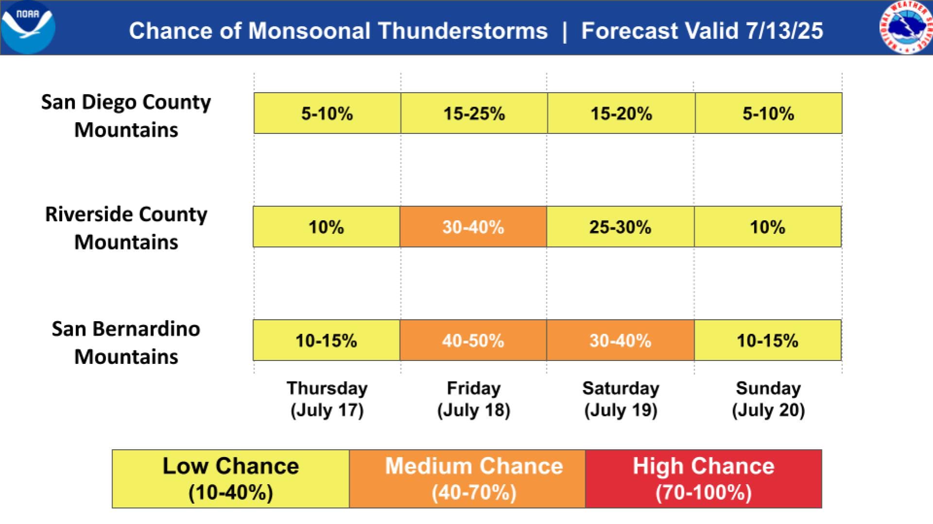
By the looks of things it’s mostly for the SD, Riverside and Berdo mountains. Don’t it will affect the ANF based on current forecast. It appears the moisture won’t venture the far north and west. Not much on this at all on the LA NWS site.
Thanks for the info! I’ve noticed that NWS San Diego tends to produce more graphics than NWS LA, and when NWS LA does, its typically much closer to the foretasted dates.
I looked this am and it does have some intrusion into Friday, and there is a signature for some spread between DP and Temp which would lead us to expect a mix of wet and dry storms. A lot goes into that type of forecast… steering winds, lift indices, PW’s…
There does look to be a decent chance of storms to the east especially in eastern SDU,RRU and BDU. The coverage level does not look very heavy at this time.
If an easterly wave does develop and some other ingredients come together that could certainly change the forecast….Still a few model runs to look at by smarter people than me…
The model used can make a HUGE difference
The GFS has been on the drier side till today.
The European has consistently been wet, to wetter.
What is different is the moisture is forecast to come up Baja on the Pacific Side with the High centered over the Yuma Area and not the typically Four Corners High that historically feeds the SW Monsoons.
Time will tell. @anvilhead will have the best information when the time is right.
Still monsoon moisture..the factor that will have greatest impact will be the strength and path of the disturbance. That will provide the trigger. At this point the high resolution models are the ones that are the most trusted, the broader lower resolution models are good for trends..the high res models are good for forecast.
Right now this does not shout watch out.. just the normal monsoon intrusion. It is worth noting there has been a suppression of the 4 corners high which has had dramatic effects on the SW water and fire season.
Hopefully this comes with some moderate rain the slow their season down.
Just because it peaked my interest a deeper dive this am does show some of the moisture making further west than previous model runs. Still too early for a solid run from the hi-res models. Both PDS and the NWS SD office mention the chance for some convection they also mention a cooling trend and increase in humidity with the system. Also no big heat signature following the event. This would keep the chance for success with any enhanced IA more successful.
The upper level low over northern Baja is reminiscent of a spring pattern versus the typical monsoon troughing. With the moisture being advected into the region sandwiched between the lame ridging to the east and the upper level low I would expect that there will be a chance of mid level convection with the initial theta moisture surge. The strength and details often depend on mesoscale complexes originating from the south and east. Please note that the low level of the atmosphere should remain pretty dry and without and monsoon occurrences this year there is no entrenched moisture source to quickly draw from. There should be a lot of middle level debris clouds during the day that can prevent convection from developing from the surface. As the upper low gets closer this weekend there should be a really good chance of surface based thunderstorms over the mountains, but the key is that this is not an overly widespread occurrence and as the upper level low ejects there will be dry air and subsidence in it’s wake that shuts down the precipitation potential next week. It’s a late start to the monsoon and I would expect a chance of lightning fires possibly with the initial mid level theta surge as is typical with early season monsoon, but it will not be overly warm out and likely occur during overnight hours.
Discussing the over all set up, really remarkable how persistent the ridging has been over Texas and the south. Because the high pressure system is over flat, near sea level terrain it is not nearly as amplified as it would be if it were over the high terrain of the four corners region… and thus the net result is flat ridging over us as the north pacific ridge phases with it. There is a lot of detriment as the air isn’t moving much and we’re not getting a monsoonal flow due to the net weak zonal flow between the north pacific high and the high pressure over the south. So the whole thing is annoying with stable air and subsidence above the ocean causing a pesky marine layer every day, and temperatures are down a very degrees from average but the caveat is the drier air with no monsoonal precipitation… so fuels will take a beating from this pattern.
If the high pressure persists over the south as is modeled I would not be shocked if a mega type storm ends up in the gulf, because under that heat dome the moisture is largely conserved and stores a ton of heat and energy plus the ocean and ocean heat content in that region is cooking. So maybe our monsoon break through will be from a big hurricane pushing from the east and bringing residual moisture or shoving the ridge up onto the higher terrain.
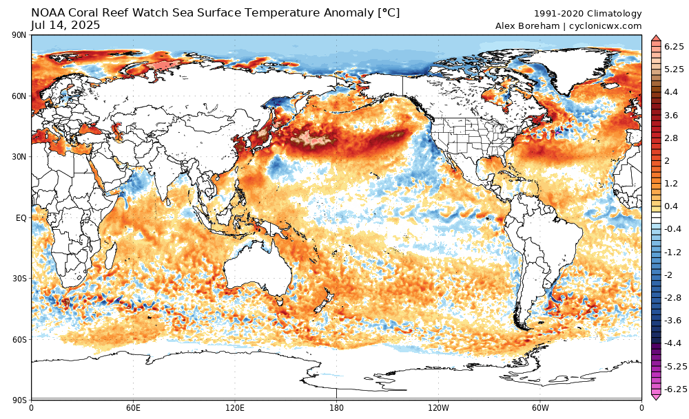
Really alarming though how much energy the upper layers of the oceans are absorbing right now, at some point the heat transfer process will occur later this summer. If I had to express it has to do with the ocean currents weakening: such as the AMOC and Pacific cold water currents becoming weaker and moving into a smaller footprint… so perhaps we are stuck in what you could describe as a perma-spring type of setup right now, with energy continuing to charge into the system.
And there folks is the response I was looking for.
@anvilhead
THANK YOU!!!
It was this type of deep level update I was looking for. 2025 is turning out to be a EXTREMELY weird year all around. With the summer in Jan in SoOps, the late start to “winter” the late/long 50-80% of normal precipitation depending on if you were North/South of the I-80. To now MAY GRAY, JUNE GLOOM, & NO SKY JULY in SoCal with the continuing marine layer. From a fishing standpoint, the Bluefin Tuna bite the last severl years has been great with the cooler SST. But those seem to flip on a dime. Or as was explained today during a meeting “it will be less of a dimmer switch, and more of a light switch” when then flip.
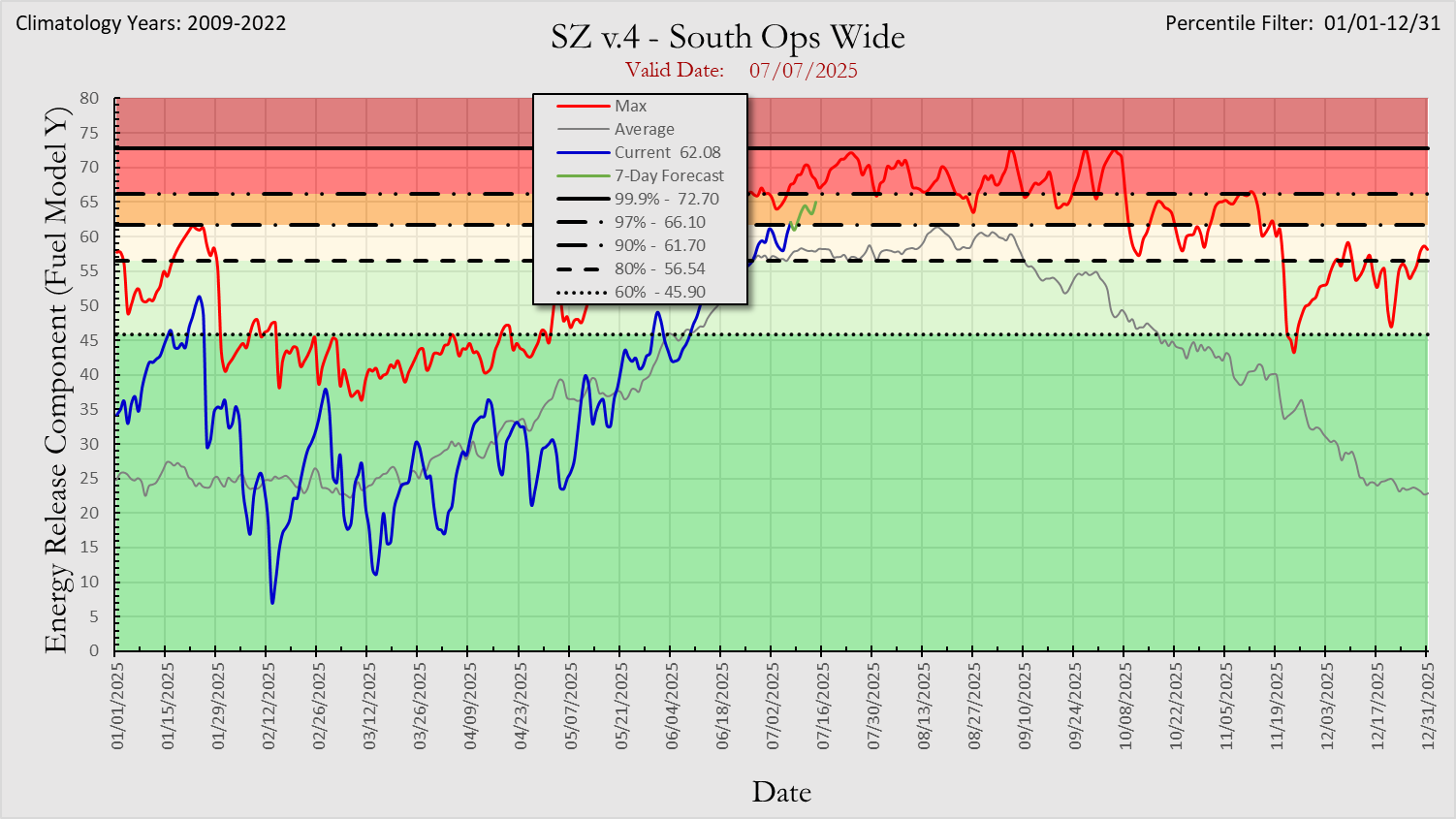
Meanwhile the 100, & 1,000hr DFM continue falling approaching critical levels, while the LFM continue to fall under the “summer like conditions”.
Spring time pattern should be coming to an end around August 4th. Thank you for your attention to this matter. ![]()
Pretty good show starting up right now looking up Highway 108 East of Sonora towards the pass…looks like lots of cloud to cloud but I’m sure the STF and TCU will be flying recon flights tomorrow. Doesn’t feel electric here at 2700 feet but is breezy and smells like rain so we shall see…
From deadwood near Oakhurst.

Piggybacking off my post from the SW area wx forum.
This is something that should never be seen on August 3rd.
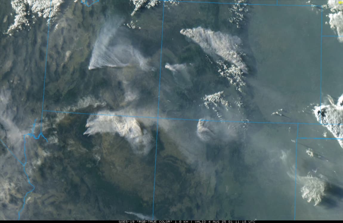
If there is no monsoon push and these fires establish the competition for air resources will further strain the situation going into the peak of fire season for CA.
Indeed, this is worrisome++
Another year of “Nonsoon” would have been helpful on my Grand Canyon River trip last June.. it showed up early and was active.