
And then there’s this –
1 Like
This is aimed at smaller drones that do add to the fight but IMHO we need more Type 1UAS with long endurance with data links and or more manned aircraft for 24 hour ISR with data links. I would
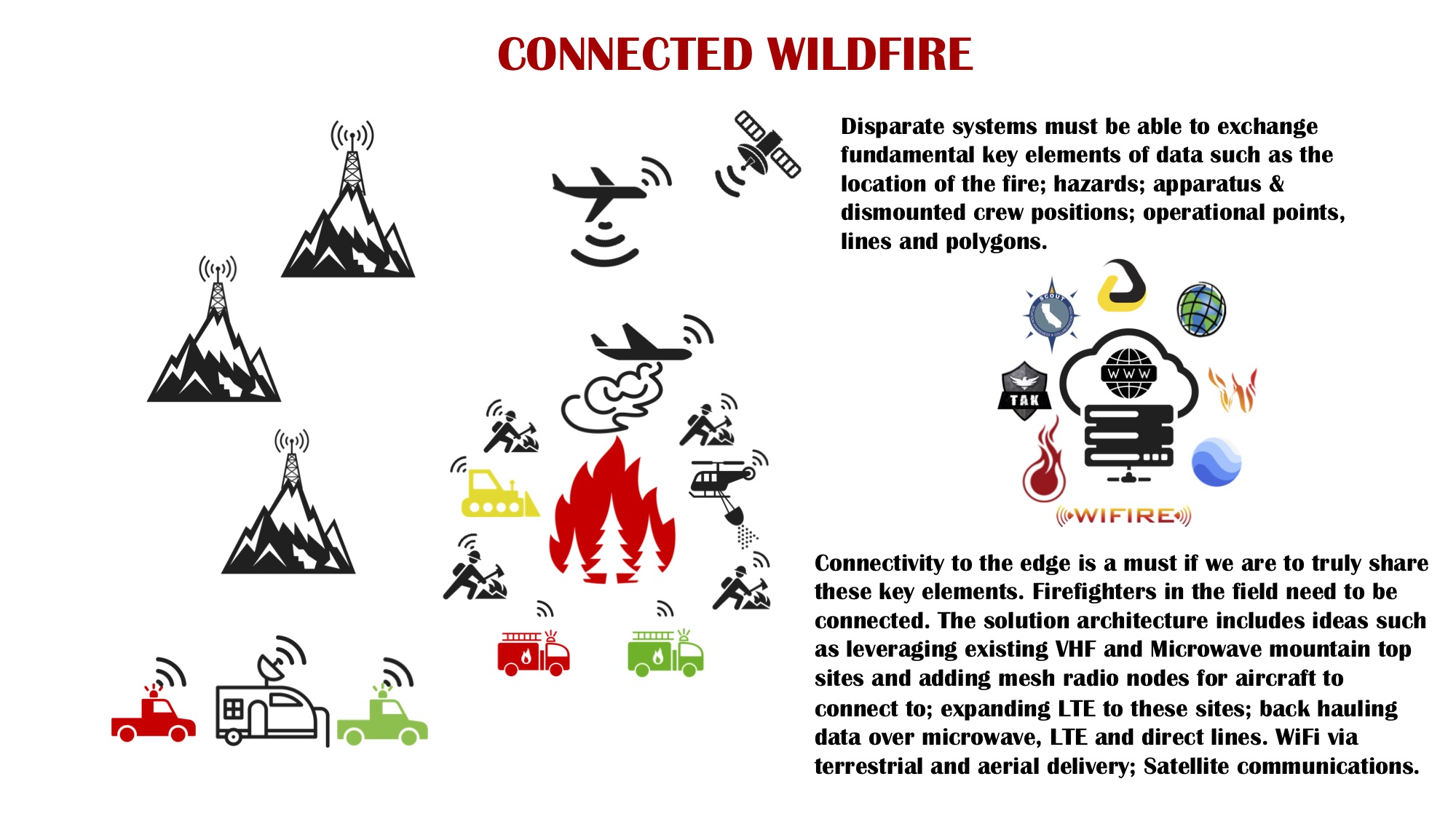
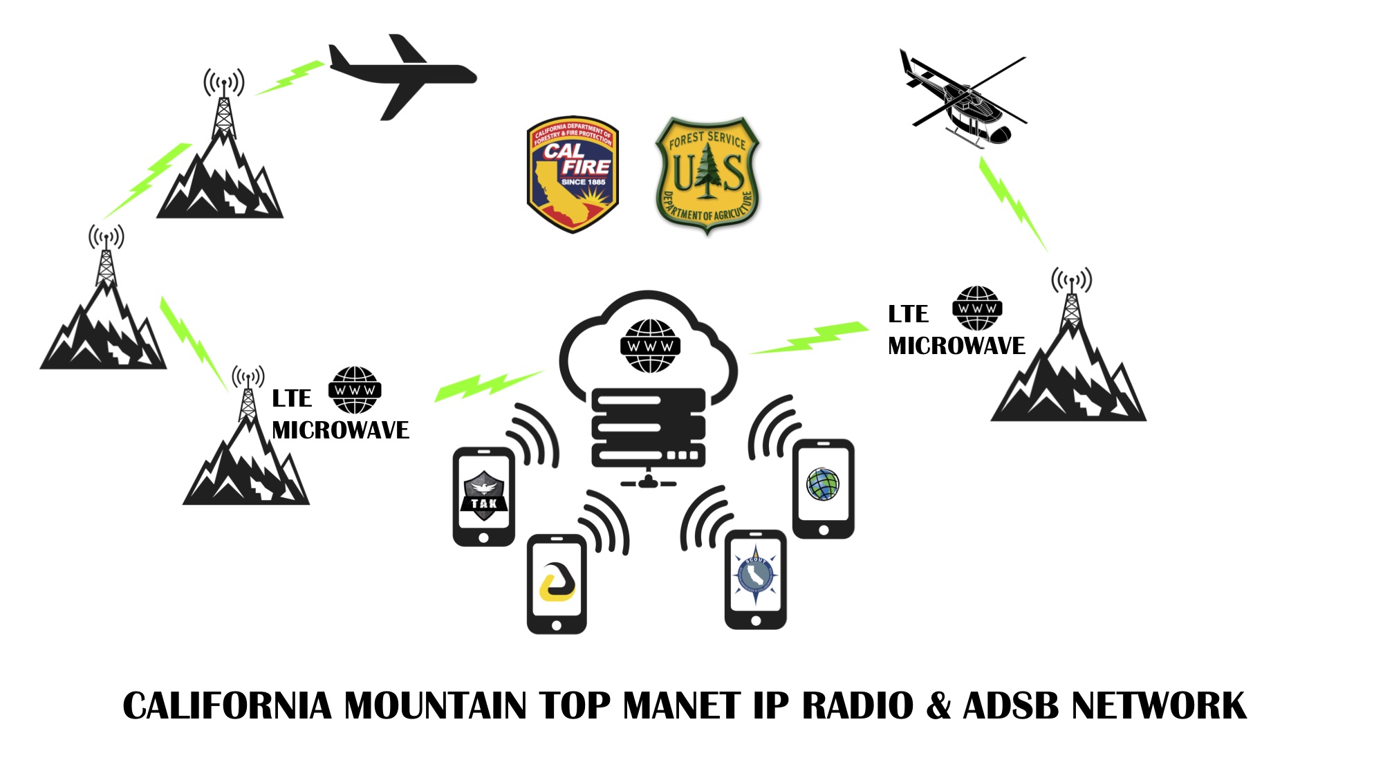
love to see a mountain top network of data links using L/S band radios on our existing repeater sites with a way to back haul to the web. No need for a data van to have to chase down an aircraft to get data. We could use the sat comms we have now but bandwidth is expensive for sending stuff like video. Lots of new sat networks coming on line though like starlink. However the radio thing could totally be done now as we have so many radio sites already. Made some schematics up a few weeks back.
5 Likes
Another big part of this is forecast modeling. So having the aircraft/satellite sensors, with weather data feeding modeling programs that can output a visual reference of where the fire will be going in certain time frames. We can take this output and export it to on scene commanders to help with their operational decisions for control and evacuation purposes.
2 Likes
That would certainly be an interesting mesh of public, and private infrastructure. (speaking for California) The only microwave network around for that is the state’s, and I’m sure that would be a pretty penny to jump onto. And then what would the handoff be between aircraft and mountain top? You have the state OV-10’s but federal ships and extended are typically contract aircraft. Adding external video capabilities (and/or mesh networking avionics) to those is a huge private undertaking. Courtney Aviation out of Columbia can pull video off and I think it’s a mixture of of cell and sat, but haven’t seen much demand on that this season. If they put it on the OV-10, how does that change their mission profile? They’re in a hard bank putting the aircraft in whatever position is needed to choreograph the airspace, now they need to worry about camera angles? Who wins the backseat pilot on that? ATGS or the IC on the ground? This is where that UAS at a dedicated orbit would be nice.
As much as this pains me to say this, a lot, this sounds like an excellent opportunity for expanding First Net deeper into the forest. There’s your already established private/public relationship. Bandwidth is there. Heck, site it on some state or federal towers and make it First Net only, or do that backroom trade deal ATT and feds have where public can be served off the cell as long as First net has full priority on bandwidth. Imagine that extra ounce of call/texting support in a Camp Fire evac situation deep up a river canyon in a beetle killed forest on a holiday weekend…  Imagine all that disgusting cell equipment and bottom-dollar install quality in the way of our state and fed radio techs.
I’m rarely a debby downer, and I sound like one here. There’s just, a LOT, of hurdles here. I’d fully support whatever, but for our terrain for now it sounds more like a Starlink goal…
4 Likes
@norcalscan thanks for your response all valid points.
- I would never task an ATGS for ISR. This needs to be a separate aircraft manned or unmanned top of the stack out of tactical aircraft traffic
- Courntey is pushing video but because of bandwidth they cannot push live unless connected to their mesh radio on their van hence my proposal for the mesh network radios as the hand off between aircraft and ground node. We could put these mesh radios on on our existing infrastructure so we can have good coverage and potential to build out the backhaul. USFS AA-51 and the Cobras also capable of video. AA-51 does video clips and sends them out via email and they are narrated. Pretty nice SA product but they have to get back to send it out. If they had high bandwidth could send it airborne. Cobras have a mesh downlink using persistent systems MPU5 solution.
- Airborne cell has potential and there are companies that can provide it to everyone on the ground and even push band 14. So like you mentioned this aircraft could be dual purpose overhead. Build the connectivity bubble and also send data. But they have to be overhead so if they have multiple missions the ground folks loose their network if they were in a cell void. I really think companies like Somewear labs is the answer for the dismounted position location. They have a plugin for ATAK and it can send position, chat, points, lines, polygons.
- Your not a debbie downer all things require 360 views, pros, cons but the discussions need to be had. If it is mesh radio the hardest part will be which solution we put on the mountain tops. The airforce does this over wide areas with persistent systems. Silvus also very popular.
4 Likes
Now you have me thinking more along mesh, and I could even see some “ad-hoc” mesh setups on mountain tops similar to NIFC portable repeaters. For aircraft you’d just need one mountain for an incident, for some ground coverage maybe two. Backhaul it to an area WISP, pre-established partnerships (fire cams cough cough), etc.
1 Like
If we built it correctly with existing infrastructure you would rarely need adhoc set ups. Most of these can push full bandwidth at up to 60 miles and these vans are parked on the ground. Imagine these radios up on an existing repeater site! Initial attack full ISR right our the door. I will keep dreaming.
3 Likes
USGS shows some fire and satellite stuff.

7 Likes
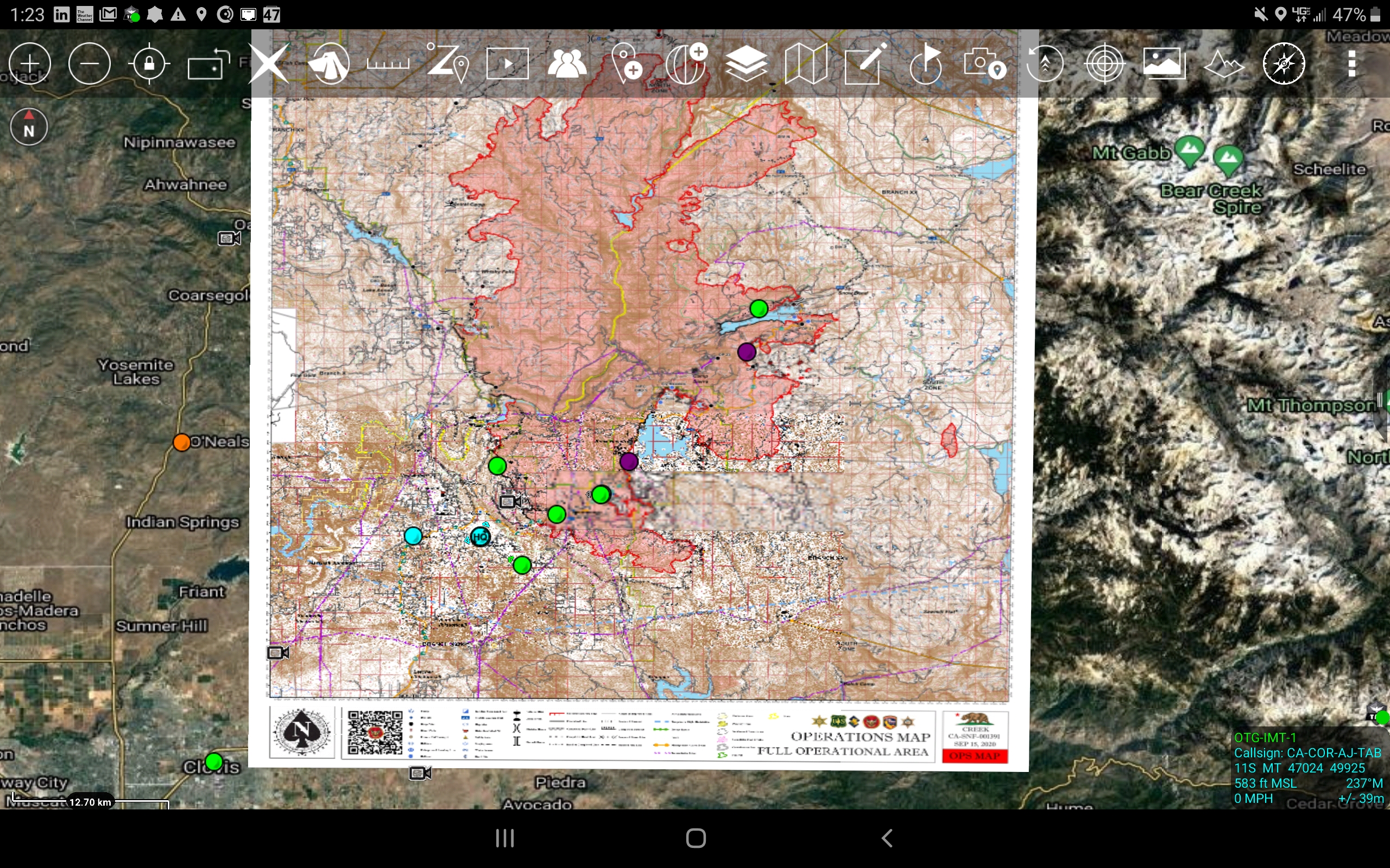
Cool screen shot of all the ATAK EUD markers on the Creek Fire. CAL-FIRE IMT-1 testing out this tech for tracking personnel and sharing data.
8 Likes
if i can figure out half of what this thing will do it’ll be a sucess 
7 Likes
New device released from Samsung. Kind of the sweet spot for on the line. Has a swappable battery.
6 Likes
If anyone wants to hop on the OPEN TAK Symposium its today. Sorry for the late notice , its started but havent missed much yet. I think you can still register and get right in. This is following last weeks “government” TAK Offsite.
https://register.gotowebinar.com/register/7983186002512775180
1 Like
A bit of cool news. In the next full release of ATAK it will support geopdf natively. I tested today successfully. No need to convert to geotif etc. IMT’s could create a zipped folder with all the data they would want to release for an op period (maps, kmz, IAP) and in one download/import you have it all on your device.
6 Likes
crosspost from CA-PNF_Adams about new emerging tech using Realtime.Earth. Recovering fire behavior and resource tracking from footage from the two Alertwildfire Cameras on the CA-PNF-Adams fire using our browser-based Realtime.Earth tool. Hoping to release RTE soon to folks in here to try and give feedback.

5 Likes
Realtime.Earth analysis of 4 Alertwildfire cameras on CA-LNU-LightningComplex fire capturing 40 lightning strikes from 630-730a on the morning of Aug 17, and relating them to 4 independent starts observed in cameras 10-30 minutes later. crosspost from CA-LNU-Lightning

9 Likes
Realtime Earth needs to be our WebTAK.
1 Like
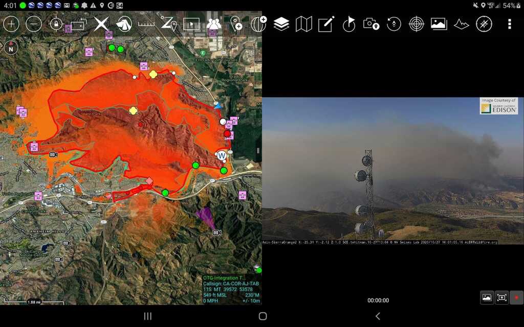
So we did some cool stuff this week with ATAK. Integrated the FIRIS (ISR Intel Proof of Concept) plane perimeter data as a streaming KML into ATAK. Then also integrated the Wifire modeling into ATAK as a streaming KML. Here is a shot from the Blue Ridge.
10 Likes
The International Public Safety Association is having an ATAK webinar on Novermber 12th 10am Pacific Time Zone.
https://register.gotowebinar.com/register/4068490301174270221
5 Likes
Here is a link to the video webinar for those that missed it.
https://drive.google.com/drive/folders/11OINlVIpYgSw0u6XiBOESOJqTUUmUwFA?usp=sharing
3 Likes
ATAK 4.2 is on the google play store. Biggest improvement that they did was at geopdf format. This was directly driven from the wildfire community. You can now import any incident geopdf into ATAK and even control the transparency of the map. No more need to convert to geotiff.
1 Like