Posted a new data package for cal trans cams. Not.all counties have full streams , this populates all cams that have full streams only. It’s in the data folder.
PBS and your local public television station play a crucial role in protecting communities by ensuring uninterrupted distribution of Wireless Emergency Alerts (WEAs), including severe weather warnings and AMBER alerts. This service is part of public television’s commitment to strengthening the safety of all our communities.
PBS WARN (Warning, Alert, Response Network) uses PBS’s unique reach, reliability, and local connections across America to provide a vital backup path for the FCC’s WEA system, which allows local, state and national government agencies (like FEMA) to instantly send short message warnings from geo-targeted cell phone towers directly to a nearby user’s mobile device.
If a cybersecurity incident or internet disruption to a carrier facility breaks the primary connection to FEMA, PBS WARN provides an immediate alternate source of inbound WEA messages.
So couple things. First the thread is dedicated to ATAK. Made another for emerging technology.
Second which im super excited about is the newest version of ATAK which dropped on playstore the other night has much improved processing of geopdf maps. The clarity is on par with avenza now. Try for yourself and download a pdf off the ftp site.
In ATAK open the point dropper tool, click on the Gear icon, click on “add iconset” browse to your download folder and import the GeoOps_2021.zip file.
Also working with the developers to see if we can get the export to KML, KMZ, Shapefile to include the PNG icon. This will be a nice add for the GIS folks.
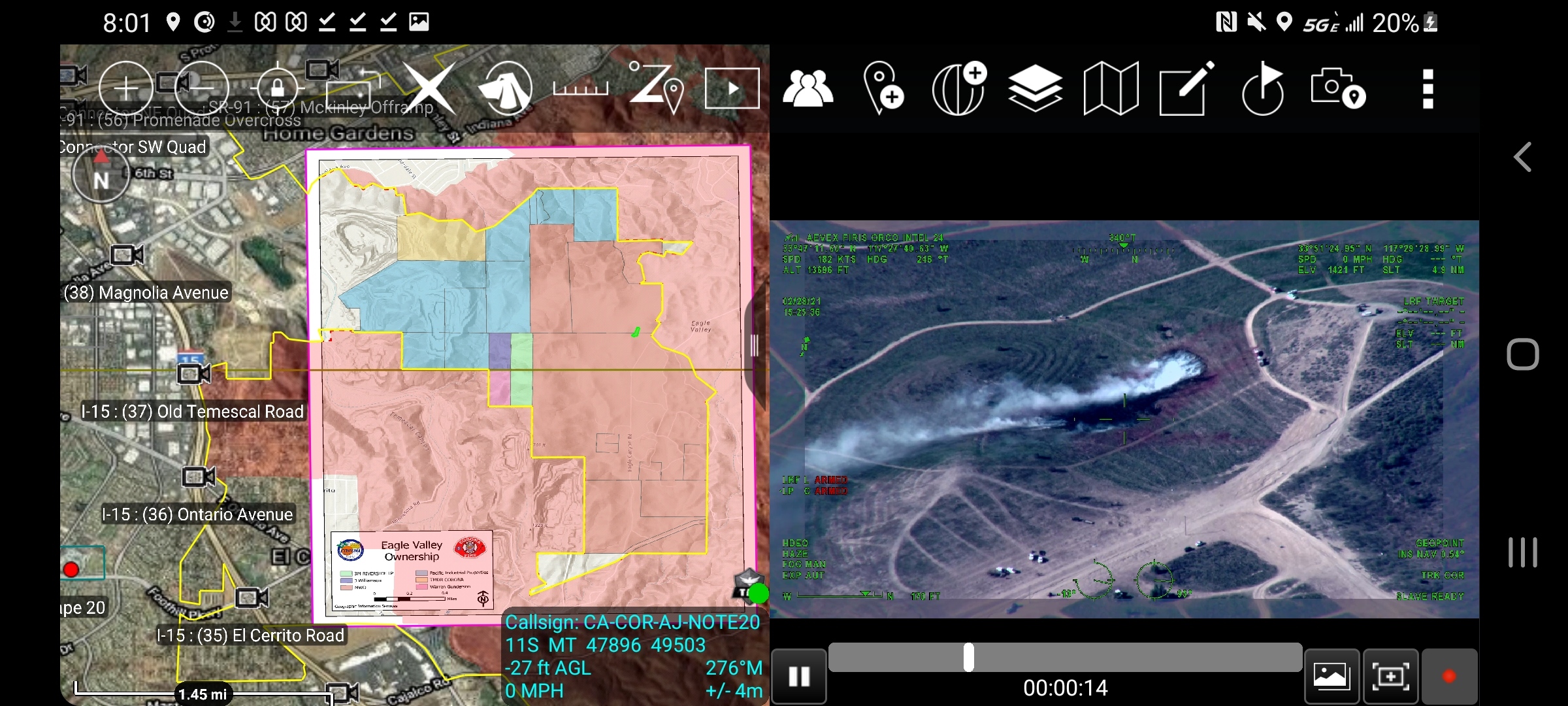
Had a little fire in town yesterday direct threat to SRA. Cool shot in ATAK, a geoPDF of the ownership in Eagle Valley, KML of our city border, DPA and the FIRIS aircraft generated perimeter. The Video i did have to download as its not live yet. Cant wait for that.
ATAK 4.3 launched playstore today. We got the PDF stuff fixed which was an unintentional by product of getting geopdf. Now ATAK treats pdf documents as well documents and pdf maps well as maps. This is beneficial because as you know with zipped files you can bring in one zipped folder with all sorts of different file types and ATAK will use them all where appropriate. So the shift IAP, All the MAPs, KML from last IR flight etc can all be packaged. as one zipped folder called a data package. You download and import this an voila one file to manage. When that data is no longer relevant just delete the whole data package and bring in the next shifts data package. Makes it real easy for teams to disseminate data versus QR codes with folders or QR code for each map. Super clean and easy and now that ATAK will render a geopdf no more need to convert to .tif format. Building data packages will be super simple.
The TAK product center has migrated to their new website https://tak.gov/ in a couple weeks it will be live with for log-in info to get apks and such. This is a great leap forward. More and more plugins will be released via the playstore as well.
Not really worth mentioning. Still in development for DHS. Improvements keep coming but its got a ways to go. If you really want to give atak a spin find a used S9 or better on craigslist and just go off wifi. If you like it and want to invest in something for the line the new Galaxy Tab Active 3 IMHO is the sweet spot.
We are taking our next step in our ATAK implimentation at work and I uploaded the ppt presentation on the basics of ATAK use.
You can ignore the stuff about TeamConnect etc.
This covers a lot of mapping information, including importing maps from FTP site. This same method of importing from FTP site is the same method you would import from the tinyurl site. So any data I have in there use the import tool to bring into your ATAK device. It starts on slide 130.
I am gonna make a video on how to create data packages for ATAK.
Once you register there is a whole catalog of training material on there but its protected behind the site.
Outside of the website there is some publicly available training and information.
There is an ATAK youtube channel with lots of videos.
If your looking for what the tools do once you download atak on to your device it does come with the pdf manual imbedded into the application. I just uploaded it to TAK_MAPPING - Google Drive
Here is a promo video that shows many of the capable features. It is pretty military driven perspective but we share so many of the same needs.
Here is a presentation I have last year at the TAK Virtual Offsite. It was to ATAK oriented people so just showing them how we are leveraging it. It does show off some capability.
Last but certainly not least from the great folks at the Colorado COE.
The training powerpoint i uploaded to the tinyurl shows off most of the basic tools and stuff you would use for wildfire. I have all those streaming service up in my tinyurl so you can download to the device use the import manger to bring them in. I am thinking about making a more generic ppt for folks who maybe arent connected to a server and how to browse to the data I have available and how you can get it up and running on the device. Also going to put in there how to create a datapackage outside of posting it on a takserver/teamconnect.
Also if you just scroll back through the beginning of this thread there are some posts on specific items etc. Many of those things I will incorporate into that generic ppt training slide deck.