Here is a great write up in storymap fashion on TAK / DART this summer. DART on the Caldor Fire
Is there a way to upload PDF text Files into ATAK from your phone and/or send them to people within ATAK?
1 Like
Yes you can do that. The cool thing about ATAK is the ability take a number of file types, zip them up in a folder as well and send them as one file. So a kml/kmz, geopdf, pdf, jpg etc and only have to send one file.
1 Like
So i did some testing in the new version 4.5 that just came out. Some caveats with pdf.
Geopdf you can bring in raw pdf.
Regular pdf document you cannot, it has to be in a datapackage aka zipped format.
This i guess was artifact from the request of finallly getting geopdf.
2 Likes
this is the coolest thread i’ve had the pleasure to read. yal are awesome as you are knowledgeable. thank you for the help.
is there also a way to send photos over tak chat and pop up on the message?
or am I just going to have to trust the data package transfer notification.
So you get a notification but it does not show up in the messages area. We can massage that out a bit more.
For now send the marker or pic you wanted and then follow up with a chat message to user but we can look at adding things to a chat mesaage.
Keep the ideas flowing
1 Like
Here is my presentation from this years TAK OFFSITE.

4 Likes
Good video from Bernalillo County Sheriff on how they are leveraging TAK. While we were there they showed me a video where they got a lat long of a fire and dropped it in TAK. Their flight computer on the helicopter can overlay that on the map and it will show up in the camera. They fly out to this reported fire and cant see anything on visual in the camera. Its just a smoldering fire. The put on the IR and boom there it is right under the TAK marker. Technology.
3 Likes
Hi,
This is fantastic. I know that this was posted over a year ago but do you by any chance still have the link? Thank you
it was posted 3 days ago, is it not working?
I haven’t seen it, are you able to forward it please?
Much appreciated
Click on the link above. It should work I just tested it.
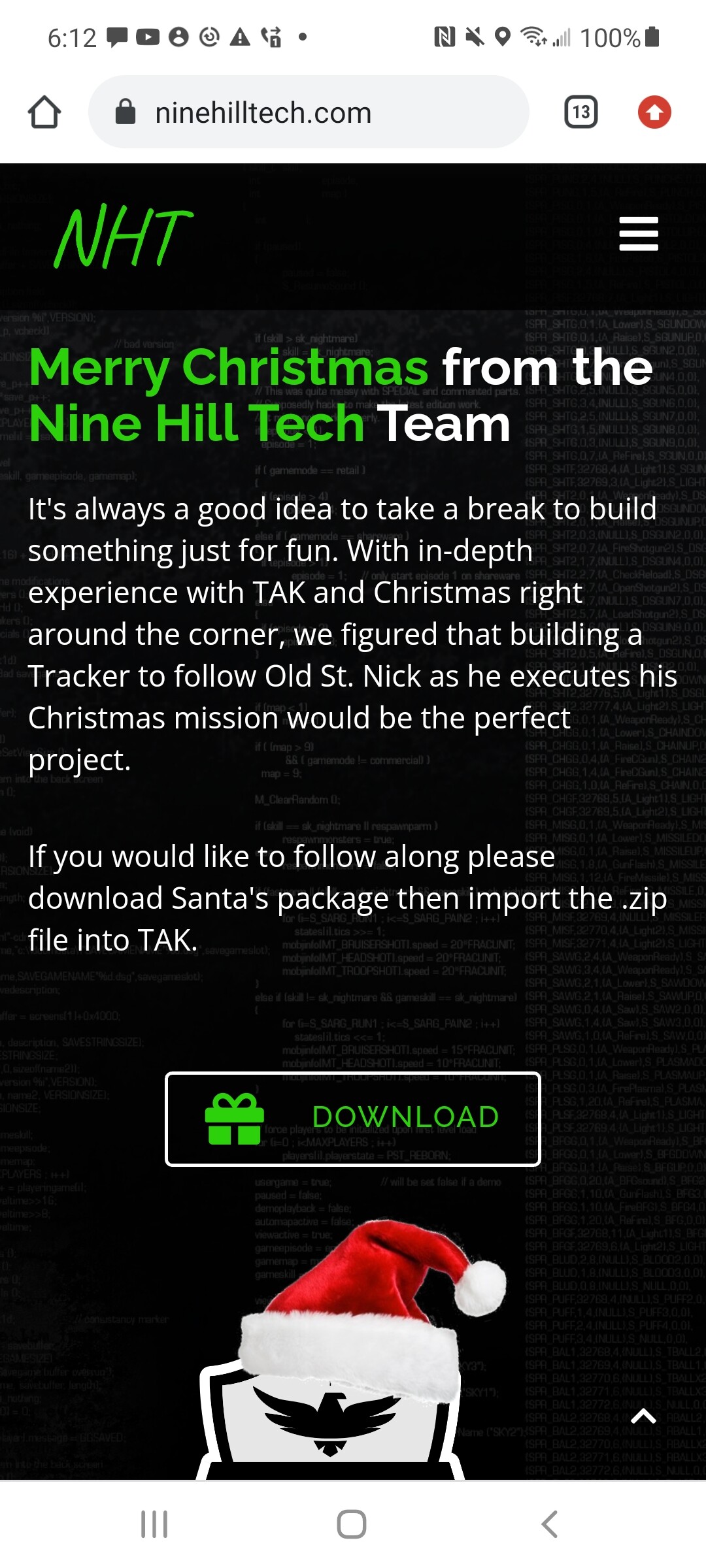
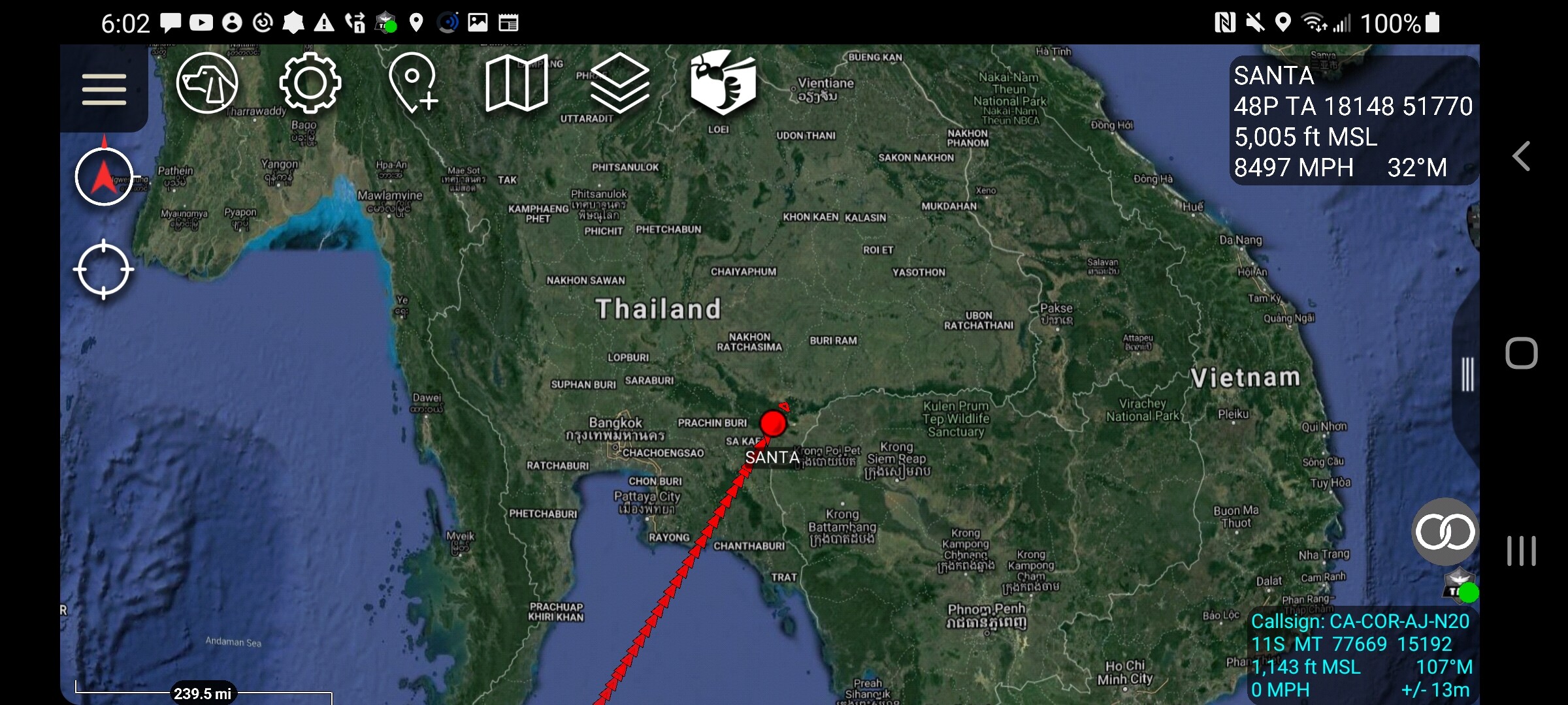
If you want to track santa in ATAK head to https://www.ninehilltech.com/ and download their Santa tracker for ATAK. After download use the import manager in ATAK and voila. Amaze the little ones in your life or even some adults!
3 Likes
TAK Fans,
The ESRI ArcGIS plugin is finally on https://tak.gov
Now you can get all that arcgis onlione data that your agency may have on a server thats perhaps password protected (If you have a NIFC account for example) or even open source stuff like traffic that ESRI hosts for free.
Not everything renders perfectly but its a great start. Its still in beta. Here is a shot of traffic layer.
4 Likes
More news that I forgot to mention. The new gui is out in 4.5 but all the guts are still there just laid out a little different in the toolbar.
Im playing around with an FTP server thats hooked to my google drive so you no longer would have to go to http://maps.takserver.us and download a data package and go to import manager to get it into atak. With the cloud/ftp plugin for atak you can go right to my google drive directory. It will download and import any data you choose right into ATAK eliminating many steps. I have a 7 day free trial so for you tak geeks give it a try and let me.know what ya think. You will need the plugin from tak.gov. once you have that import this pref file into atak and you will have all the stuff you need to browse my google drive. The name.of it is FIRIS for now as I was showing the firis team how this could be leveraged to share their geospatial videos to tak users without the need of a takserver.
But im gonna have to make you go to http://maps.takserver.us one more time to get the firis.pref file. Download and import.
Made a video of how it all works.
3 Likes
Made a short video on geospatial video in ATAK and what its all about. We wont all always have links to aircraft but its worth knowing what can be done with it. This could be from a small quad copter, a helicopter, fixed wing or an MQ-9. ATAK handles it all the same if the metadata is sent with the video. If you want to see what this is like for your self in ATAK. I have a couple videos you can download and play in ATAK for yourself. You can either go to http://maps.takserver.us or go through the Cloud/FTP plugin and browse to a folder called Video. I have two files in there. One is called Truck.ts which is just a video file and is what your watching in the video. Once you get it in ATAK open the video player and search for “Truck” and hit play. To center you map on the video hit the little icon that looks like an X, if you look its actually 4 little arrows pointing to a dot but anyway I dont know what the heck the icon is called so best description is an X. You can follow along in my video and can see how this all works. The other file i have in the Video folder is a DataPackage named DP-Thomas Fire. It contains both a video and the ops map from the Thomas Fire that corresponds with the date the video was taken. You can get to both the video and map from the DataPackage tool or just go to the video player for the video. Whats cool about this is you can see video of a fire in reference to an ops map. Videos are cool dont get me wrong but if you have ask where is that then your without probably the biggest contextual part of the puzzle. If you have questions let me know.

1 Like