Great article on UAS and ATAK integration in the may issue of
1 Like
Here is a video I made during the Mosquito fire which was made initially for internal sharing of FIRIS capability and integration into ATAK. Got permission to share publicly so enjoy. It’s main purpose is to highlight the increased context you get with having geospatial properties with video compared to just video alone. This can come from a drone, manned aircraft, still camera etc. Where the camera is facing etc increases the context a lot. This video was made live, this is not a recording of downloaded video played back in ATAK. This is the exact same program that the TACPs use when they imbed with us from the DRTI platform. In all reality, we could be doing the exact same thing DRTI does from our agency and contract aviation with the right radios in our hand. If the aircraft can transmit via satcomms like FIRIS and you have an internet connection where you are you don’t even need a downlink radio but if you are in a no-cell zone you will want the radio. This would be for a Branch/Divs. Many of the contract planes already have the downlink radios installed. We just need to put someone on the ground with ops who knows how to use the radio and ATAK.

2 Likes
If your thinking about dipping your toe into ATAK I made a little video on some cost saving ways to do it.

1 Like
No industry standard.
Courtney uses Silvus
Aevex which is CAL-OES Firis and USFS AA51 uses Persistent Systems.
I cant remember if the CO MMA has a downlink on it I will have to text a friend.
1 Like
@NaterD15 - Aevex is the aviation contractor for Firis and AA51 - Persistent Systems is the brand of their downlink mesh radio.
They also have a satellite link which is how FIRIS sends the perimeter data when they are airborne.
Want to deploy your own TAK Server to see what the hype is about? You can do this for free for a few months. After that depending on your cloud provider it could be 48 bucks a year! Check out this alternative to Digital Ocean or Linode. They are having a killer sale. SSDnodes

1 Like
Helibase mangers, your gonna love this.

2 Likes
Awesome to have a plug and play/dummy-proof PiAware-esque setup in a sturdy field-grade box. Any idea if it’ll natively stream the data over to FlightAware/ADS-B Exchange if there’s internet connectivity?
It can do that if desired. Or send it to a tak-server or both! Reach out to greg at Sensors and Signals.
I did a segment on the SmartFirefighting podcast. Its focused on TAK and situational awareness.
2 Likes
If your curious on what you can do with FIRIS data in ATAK check out this video.

2 Likes
If you have used the VNS Plugin in the past and noticed that you can no longer get a routes its because the API key that we all shared has been revoked. Each agency/group etc has to have their own API key now. This video shows how you can do this. You get 200 bucks of free credits a month and its fractions of a cent for every time you want to use it.

1 Like
If you or your agency is interested in an in-person 3 day ATAK training course, Prevent Training in Riverside is taking an interest list to see what the demand signal is. I will be teaching it with a couple other SMEs. The course description is in the link at the bottom of www.thetaksyndicate.org
1 Like
Great new capability for live geospatial video in the AVO plugin for ATAK. You can now lock the map to the gimbal orientation. Check out this video where I have have the map orientation following the FIRIS camera gimbal.

2 Likes
If you want to try out the AVO Plugin for 4.10 with some geospatial video I have two canned videos. One of a truck rolling down the highway and another one from the Thomas fire. Go to maps.takserver.us and open the video folder. Download the truck.ts file and then import that into ATAK. To play the video open the video player and search for Truck and it will show up. Click play. Upper right hit the icon with the 4 arrows pointing in. It looks like an X. Its right next to the globe. Tapping on that icon will take you to the aircraft position on the map. I have a youtube video just on general geospatial video here.

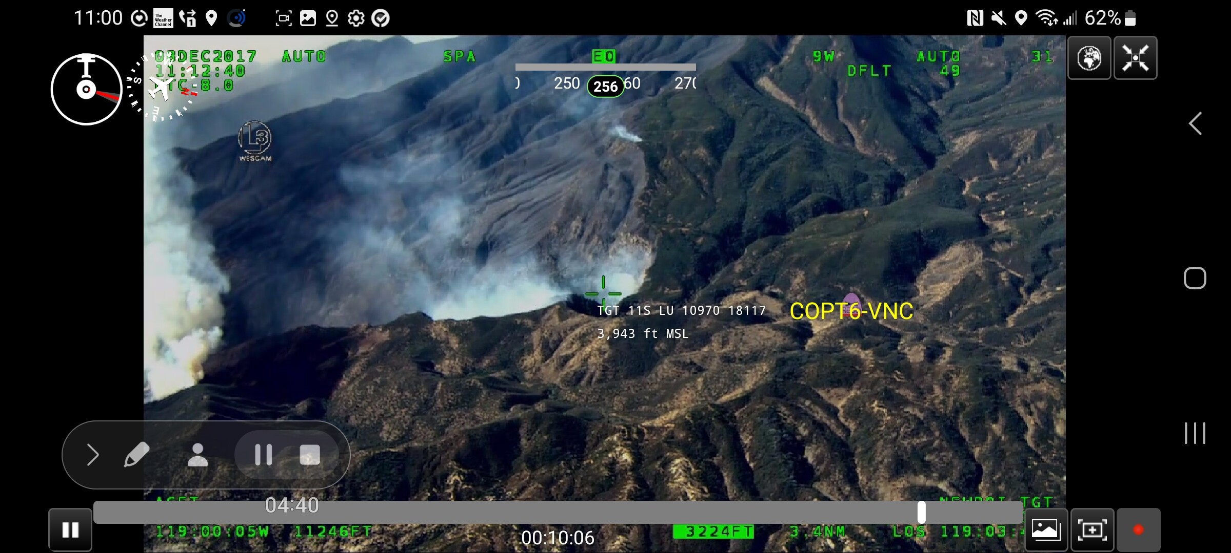
The Thomas video is in a datapackage that also includes the ops map from the day the video was shot. So you can watch the video with ops map as a layer. Download the DataPackage (400 mb) then use atak import feature. After you get it imported you can open the datapackage and load the ops map. (you cant play the video from the data package. ATAK Moved it on import) to play the video go to the video player and search Thomas and it will pop up. If you have alertwildfire cams in atak it will pop up anything with the name thomas so you may have to scroll to get to it.
Last but certainly not least is the augmented reality portion of the AR Overlay AKA AVO plugin. Any object that is on your map will show in the video. I was doing some refreshing of this to help folks with training on the AVO plugin and was playing the Thomas Fire video and VNC-Copter 6 was up flying and flew into the same frame as the video and showed up as augmented reality.
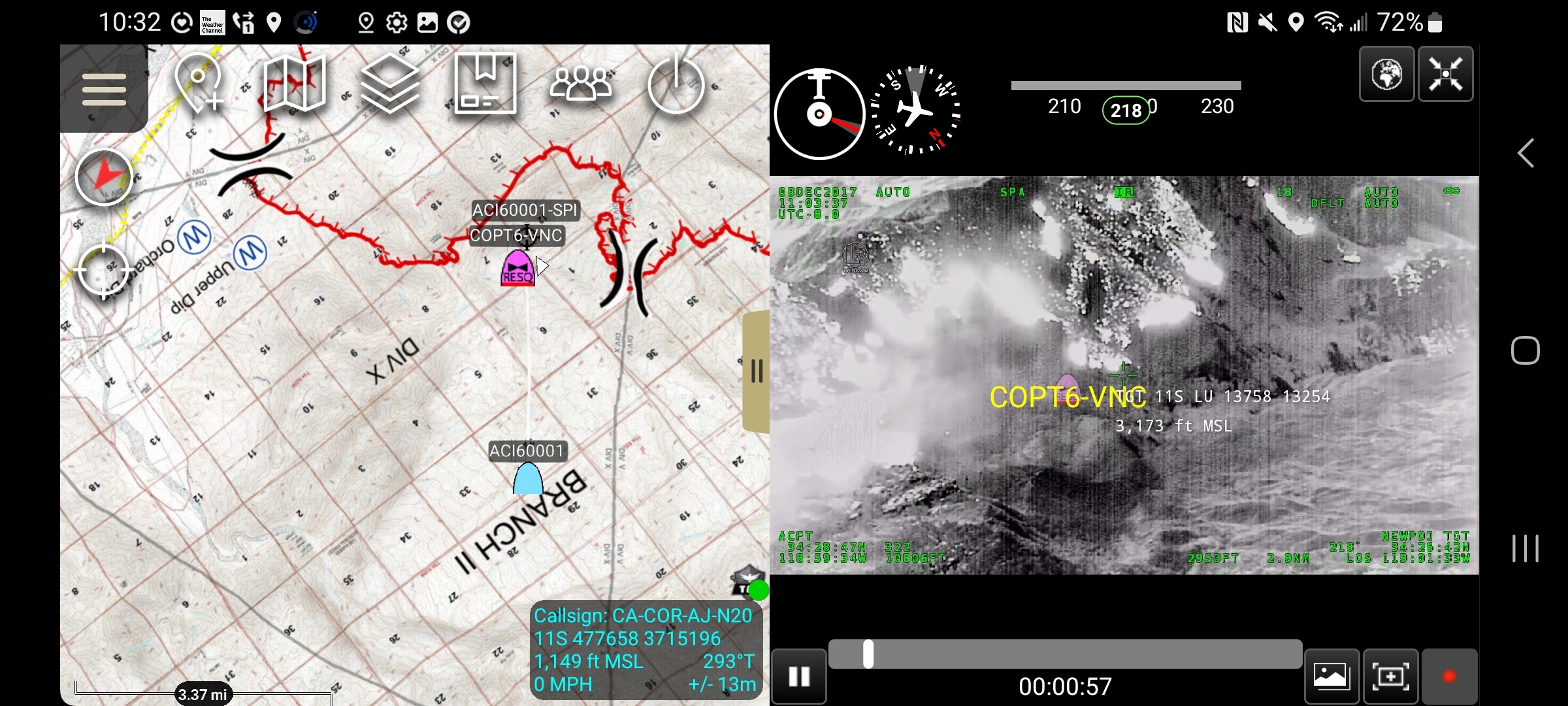
I will make a separate video next week on how the AR works with this plugin next week. If you have watched my UAS tool video it is shown off in there.
Another video just released this morning. A comprehensive review of the ATAK UAS-TOOL. In this presentation we have ATAK - UAS Tool running on an Rx Fire. Enjoy.

2 Likes
Great TAK write up from Damian Gulliani the SITL on CA CIIMT 4.
3 Likes
Check out the state of colorado’s TAK landing page. Awesome to see the progress here.
1 Like
Great write up on the TX TAK workshop by Pleasant View Fire Dept.
There is another youtube site for learning the ATAK tools. So far it looks really good.
2 Likes