To further define this, the dividing line is the border between the El Dorado NF and the Stanislaus NF. And between El Dorado and Calaveras Counties.
Pretty well defined.

To further define this, the dividing line is the border between the El Dorado NF and the Stanislaus NF. And between El Dorado and Calaveras Counties.
Pretty well defined.
I suppose, just offhand, that most people from California would consider the Monterey/San Luis Obispo County line, east to west, to be a more intuitive boundary. Then, maybe, angle up between Yosemite and Kings Canyon, or maybe between Yosemite and Lake Tahoe.
The items you posted clearly state what I have been saying.
It is what it is. The alignments have changed over the years…SCU and AEU used to be a bit more SouthOps oriented when there were 6 CalFire regions. But that has evolved.
Most people aren’t running North and South Ops. There must have been reasons, as the Feds and the State had to agree to make the alignmentswork for both.
Fun Fact. The geographic center of the state is literally delineated by a palm tree and pine tree on HWY 99 between Madera and Fresno… Yup! (actual center is east of the HWY in the middle fork I believe.) Freebie for the day.
…and so it serves to divide a Federal National Forest split between two regions, more or less equally with regard to density and travel time between them, with a carve out for SF. And for an agency funded to 40% of its responsibility. Just give them back, lol. J/K.
So if you look on a map. TCU and BEU are the start of SOPS. Kinda like a sideways S. Not a straight line. And whatever Forests, NPS, FWS, BIA, and BLM land fall under those lines, which then lay in their respective GACC.
Download that, draw the GACC Ops line on it, and upload that. I don’t know exactly where that line is, or as already posted, its just fuzzy.
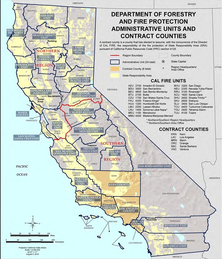
This should help
The easiest way to know if it is a NOPS or SOPS incident is this: If the CF Region number is a 1 or 2, it’s NOPS; if it is 3 or 4, it’s SOPS
What NF is split?
Not a split of a forest, but a split of the forests.
In light of this map, you say TCU was put in South for reasons, okay. Mono and Inyo make sense together. Intuitively, SC and Monterey Counties split at Pajaro, but they are really sort of one economic area. SC is sometimes called part of the south bay area, but not a lot. It would seem to make sense to keep Monterey Bay together, but that cuts off the top of LPNF, I guess. Its awkward, but surely there are some factors being left out.
TCU is SOPS as shown on the map above and carries a Region Identifier of 4. The NOPS boundary units are: CZU, SCU, AEU. Everything above that line is NOPS, everything below is SOPS with the boundary units of BEU, MMU, and TCU. We are making this way more complicated and complex than it needs to be.
You see a lot of Bay Area weather reports include Santa Cruz. There’s a pretty heavy commute on the 17. Its fine. Awkward at times, but fine.
TCU was not put in the North.
Was in the North. Fixed.
Part of Mono County is GBCC. Somewhere around Conway Summitt is the boundary between OSCC and GBCC.
Not on that map.