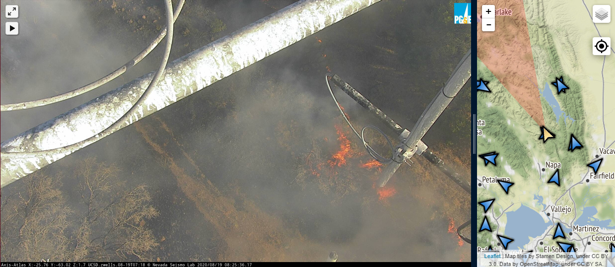
Just saw an article in my local paper about new network of web cams for fire detection in CA and other states. Looks pretty helpful for early detection or and confirmation for reports that come in. Alert Wildfire
From their about page: “ALERTWildfire is a consortium of three universities – The University of Nevada, Reno (UNR), University of California San Diego (UCSD), and the University of Oregon (UO) – providing access to state-of-the-art Pan-Tilt-Zoom (PTZ) fire cameras and associated tools to help firefighters and first responders: (1) discover/locate/confirm fire ignition, (2) quickly scale fire resources up or down appropriately, (3) monitor fire behavior through containment, (4) during firestorms, help evacuations through enhanced situational awareness, and (5) ensure contained fires are monitored appropriately through their demise.”
You’ll notice that for many of the new starts in California posted on this site have pics or links to these cameras or other older networks like HPWREN, SWFRS, etc. They are extremely useful for info sharing and for first responders and leadership.
Yes as a SITL I have taken advantage of the many older camera networks, just that this is a new network that everyone may not yet be aware of. Good addition of intel in our quiver of intel sources!
HPWREN could add more AAB cams if they are requested by the agency. Minimal cost for a HD camera like the one Ramona AAB. Cameras are powered by HPWREN and SD County Fire Authority has collaborated for high-speed wireless/internet at many fire stations. Also some USFS faculties have wireless from HPWREN, so adding a HD camera to the network is easily done.
HPWREN could also connect RRU Hemet/Ryan airbase from the network relay up on Santiago Peak, which also has cameras. The agency Cal Fire - RRU has a tower on the ramp that could have 4 cameras for a 360 view. Many of the cameras don’t cause issues with location.
I was instrumental in getting the Ramona AAB cam installed before retiring, in exchange for high speed data HPWREN/Wireless access for the airbase. I didn’t get even try for permissions since I’d already filed my Retirement papers. Management was receptive after staff saw the cam images and in full agreement.
That timelapse feature blew me away when I found out. Another trick I found was in the layer field on the map (upper right above the crosshairs) is to make sure the Camera View Field is on, which is pretty accurate, and then toggle the Camera Targets on/off as needed. What the camera operators are doing is putting the smoke in the center of the camera’s field of view. The Camera Target will put a line down the center on the map. With multiple cameras aimed, you get a pretty accurate triangulation for the fire. Also make sure the timestamp on the bottom of the pic is current. You might be looking at old footage if the data link had a hiccup, or the equipment case flooded in the rain (ahem Konocti).
The agencies today have much to lose from these Comm sites impacted by wildfires, not to mention all the new cameras being installed. . We’ve seen way to many being threatened or destroyed because of the lack of any defensible space. It’s never been a priority by most agencies to have these sites cleared off and defensible.
During the 2003 Cedar Fire, as the ATGS we put 10 S-2 loads of retardant around the SD County North Peak Comm site. That’s over 9,000 gallons to save the 2 acre site? It was spared major damage, but the retardant drift has caused many issues in those steel towers.
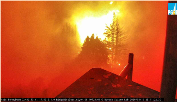
East Quincy is next, although it looks like it’s backing fire and not taking on a wall of fire. However there might be clearance issues here where even a backing fire can be jeopardizing. I watched two cams yesterday go down live, not sure I can watch a third.
I’m 22yr sysadmin by day, I can’t help but personify electronics. Servers are supposed to be cattle, not pets, and I treat them as such, but these fire cams are like silent sentinels watching our backs so we can sleep at night. They are absolutely our pets. Hang in there East Quincy!
Curious to know who (assuming PGE command center?) controls the cameras? There is a reported fire in a remote area along the Sonoma Coast at a house under construction right now and I checked the nearest camera which showed nothing but was pointed in the right direction. (the incident has been since canceled and the camera repositioned back to its original position).
I did a 15min time-lapse and I could see the camera was repositioned in the direction of the reported fire pretty close to the time of dispatch. So I was just curious who controls the zoom and direction on these? An invaluable tool for the toolbox!