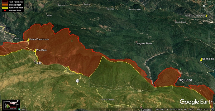
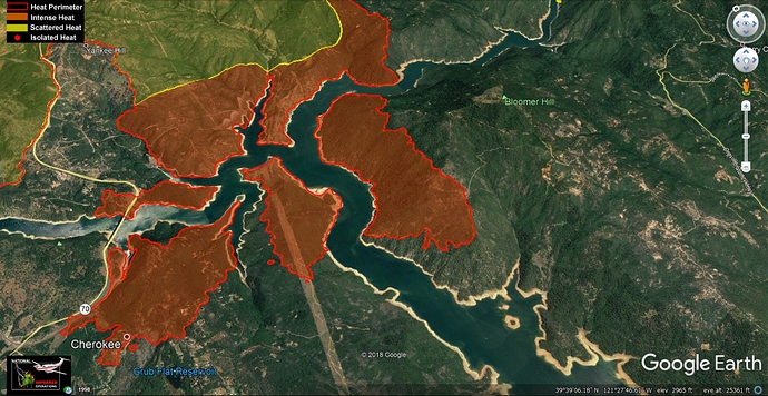
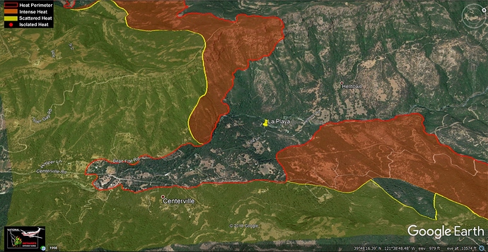
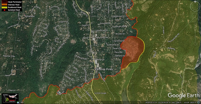
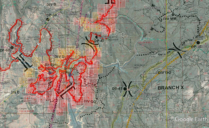
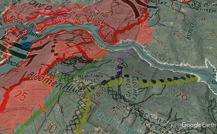
At the end of flight time, airtac did not feel the line would hold on Bloomer…could be a interesting evening/night
BCSO just confirmed 29 lives lost
Per Cal Fire 0700 update the Camp Fire went to unified command with the USFS as of 0700 today. Maybe we will get some decent maps if this fire gets listed on InciWeb.
My heart aches for those who have lost loved ones on these fires. I’m hoping and praying that no more bodies are found. Terrible.
Maps are available here:
Mapping flights are up over the fire: N149Z and “ALLIED1” are flying patterns over the fire area.
New IR map is up:
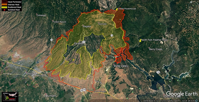
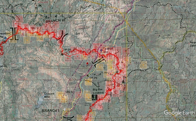
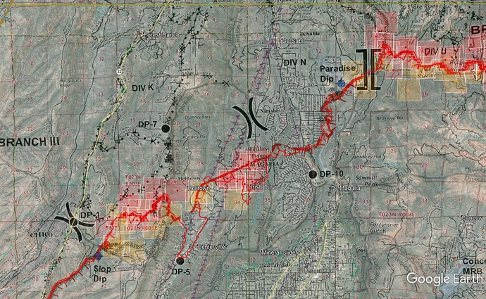
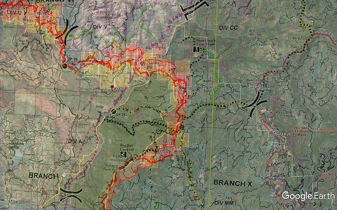
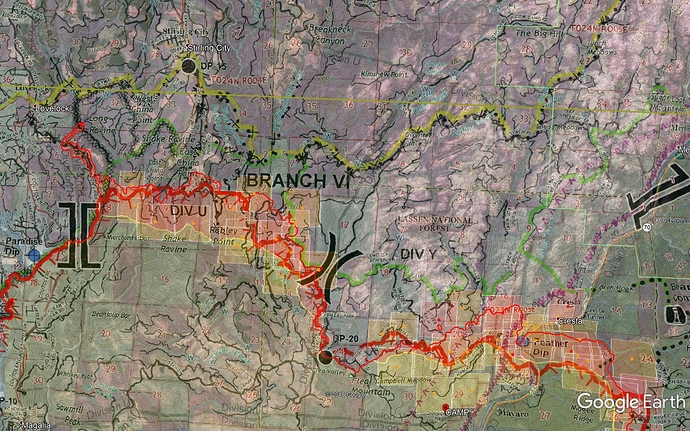
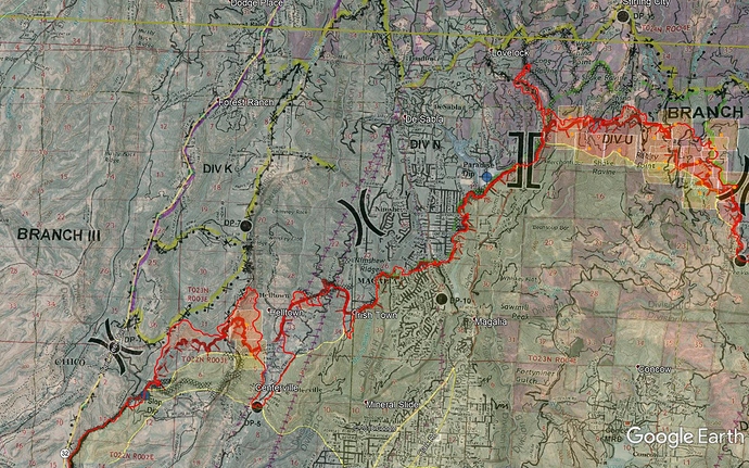
Here are Google Earth maps with last night’s IR. Sorry to be out of the action, everyone, this fire has us all spread out across the landscape.
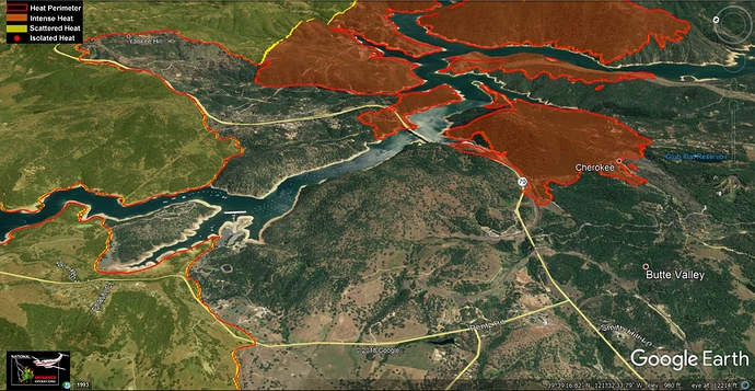
0745 Update: Yesterday afternoon into the evening became a pretty big mess down in the Cherokee and Bloomer pieces of Lake Oroville.
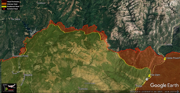
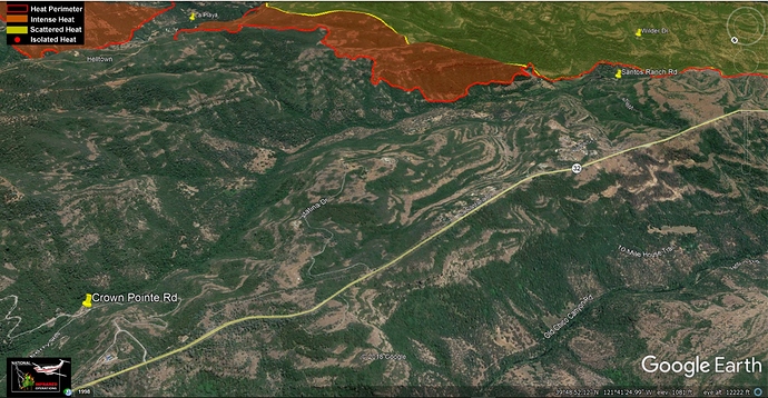
Map data is today’s Ops Map overlaid onto Google Earth, with IR data from 6:48pm Sunday night, and MODIS/VIIRS hits from the last 24hrs with the most recent passes around 0200 this morning.
Most MODIS/VIIRS data here in Div E, QQ and D is at 100% confidence at 0200 this morning. The farthest hits south in Section 3 on the Cherokee side are much lower confidence, and with wind direction probably false hits from the smoke plume.
Branch 6 and Div A/Y up near Cresta, they had some retardant work a few days ago up here, and I think they dropped some more yesterday. Ground is trying to hold it in Y along Dixie Rd. The P-Line along Branch 1 is their contingency (probably primary at this point).
Div K - the stubborn piece on the NW side just below Hwy 32 around Santos Ranch Rd. Carving out primary and contingency lines to keep spread in check to the north and west. MODIS/VIIRS confidence hits here are lower.
2 posts were merged into an existing topic: GIS and INCIDENT MAPPING
0945: Branch 6 Div Y, sounds like they lost the hold on Dixie Road and a spot has gotten established in Section 16 (in 23N 5E). Going to quickly try and see if they can use the road system just ahead of it, but without enough resources, it’ll be a long ways out until the next line.
Butte Creek Canyon and Div K really smoked in this morning, little/no aircraft support there for a while. Good air above Branch 6, will get some good fixed wing action up there today it sounds like. Launching Type1’s out of Oroville Helibase up the east side to work Branch 10 and Bloomer Hill area.
1200: KCRA3 copter over the top of Branch 1 now - live https://www.facebook.com/KCRA3/videos/880630725659683/
Good eyes into the Feather Dip and Branch 1/6 break. Clean air into the canyon.
1230: Sounds like visibility is crashing for rotors in the Div E / QQ break area (south area) and some helo’s are having to pull off for now. (Heard “Dam check” checkpoint is getting marginal visibility).
Media Briefing for tonight has started (video on Cal Fire Butte County FB)
117,000 acres, 30% contained.
Structures destroyed 7,177.
Of those, 6,453 Single family residences, 74 multi family residences, 261 commercial buildings, 389 “minor” structures
No rain expected through Thanksgiving. Winds have let up and should be topo driven tomorrow.
Cal Fire expects to have link available shortly on social media sites for checking property status by entering address.
CHP will have website link from CHP Chico website page on vehicle tow location
13 additional human remains were recovered today. That brings the current total of discovered to 42 killed. They will be bringing in additional search and recovery teams and dogs for ongoing searching of fire victims.
Structure viewer website, will be updated as they continue to do assessments:
This morning’s briefing: https://www.facebook.com/KCRA3/videos/935976669924435/
0730: showing 125,000 acres @ 30% on calfire website
0800 summary: Helos had great work yesterday until they lost visibility on most of the fire midday. Fixed wing spent the day painting well ahead of the fire in Branch X to slow it down and give the troops time to dig in and establish line. They also prepped Bear Ranch com site, a small site with UPRR microwave and Verizon cell. Looks like a firing operation up on Doon Grade Road, appears they’ll try to keep it from hooking back around into DeSabla and upper Coutolenc Rd. They had a lot of copter work up in there yesterday as well.
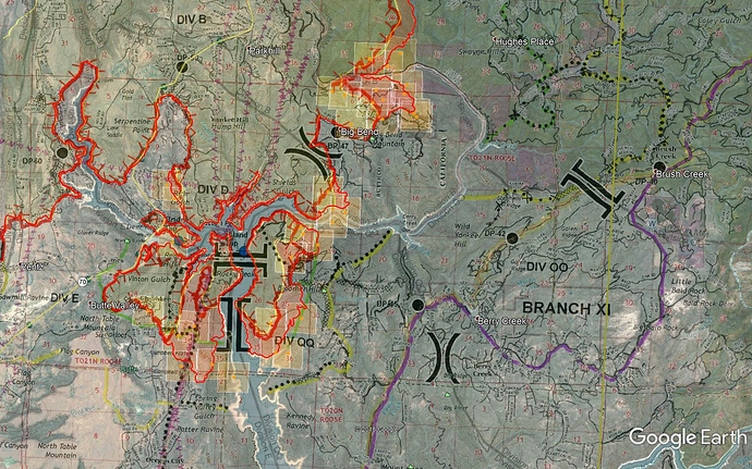
Map data: today’s Ops map, last night’s IR flight at 10pm, MODIS/VIIRS last 24hr heat with the latest pass about 1030pm last night which explains not many hits outside the IR perimeter flown 30min earlier.
Branch 11 established for the Bloomer Hill and Berry Creek area. They have been putting up a very strong fight at Bloomer Mtn. Quotes from AA multiple times yesterday “I don’t want fire past those towers”
Branch 10 - lots of retardant work in here yesterday, backing fire in timber with the winds yesterday.
Branch 6, you can see the loss of the Dixie Rd attempt in Y, and a new primary established just ahead. Lots of open land past that to the secondary line. You can see the firing ops in Div U along Doon Grade.
The stubborn Div K below Hwy 32. A run or firing op up Doe Mill Ridge
CHP Infrared Imaging from 11/11: https://www.facebook.com/CHPValleyAirOps/videos/911579355707575/
0930: I don’t normally focus on tactics at a small scale, but some good optimism is coming out of Div QQ and Bloomer area. Helco is working 5 Type 1 copters all around the fire front on QQ and fire behavior is in our favor. AA was discussing with ops bumping the primary line to the north a ridge closer to the fire and it would most likely be their final line for the north side of Bloomer. I painted the proposed line in purple below, going down Section 19 north to the river. Holding in QQ would be a great win in this battle.
Rotor disengaging due to visibility. QQ firing op in progress off Encina Grande and cutting west on Wagon Wheel.
