
@norcalscan I have been lobbying the state to put adsb receivers on mountain tops that the state has radio equipment at and backhaul the data. I think this could come to fruition to improve overall SA and tracking of incident aircraft compared to AFF. Not that AFF is bad but the interval is long. AFF though due to satelite based isnt going anywhere as someithing is better than nothing. So in the instance of the dixie you might have a bit better coverage in some of the more remote areas.
4 Likes
Just noticed on today’s maps all the Divisions have been renamed. As an ICS purist, this is not good. It will lead to confusion. If the system is broken, your better off cutting you losses and renaming them, but not If its just a little off or purely aesthics. A re-org could be the 1st link in a chain of events that go sideways.
8 Likes
Until we get an IR update, anything coming over the scanners about northwards movement? It all seems to be west to Butte Meadows, or S/SE towards Greenville. Might just be wishful thinking on my part, but the afternoon breeze today was out of the NE, not the usual daily SSW wind.
It might not be optimal to do, but it happens, or IMTs are asked to do it for overall safety. Especially if it has something to do with zoning the fire and the potential for duplicate naming conventions between east and west zones and the teams. Yes, the comm plans should not duplicate any tactical or command channels where folks on the ground would hear each other. But those flying 3-4-5,000 AGL can hear everything and it can quickly get confusing. I think most folks work it out in their brains since it is not too different than being assigned into a different division after being in one for several Operational Periods. Airspace deconfliction and mitigating confusion over call-signs for the ATGS(s) is critical.
3 Likes
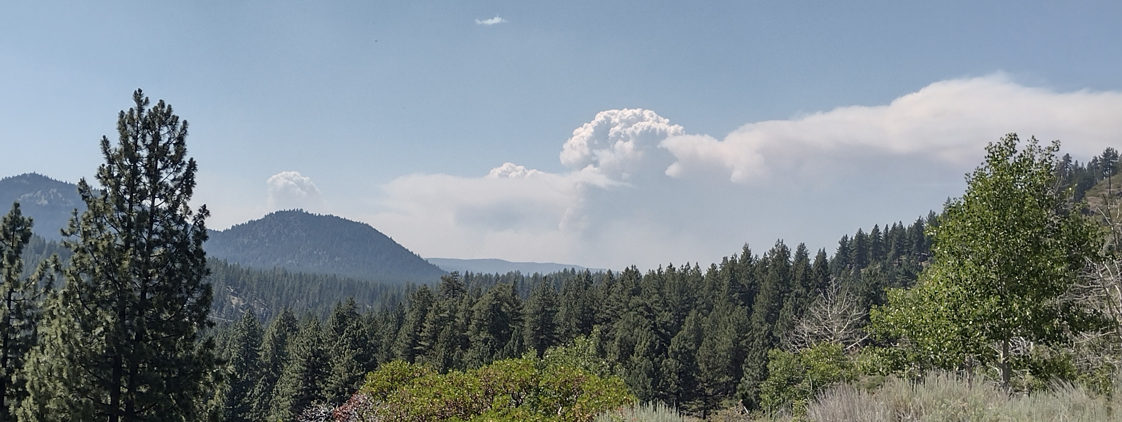
Coming out of Sacramento on the 99, theres 3 columns on this thing visible from almost 100 miles out!
4 Likes
I am seeing a header on the north Mokuleme cam…dixie, Fly, or Tanarack?
The Tamarack
2 Likes
1 Like
This was the view from Lake Davis a few hours ago looking west. Now in smoke about 1.5 miles visibility so wind is coming from west now.
2 Likes
State Route 32 is closed now from Butte Meadows turnoff (Lomo) to State Rte 36.
4 Likes
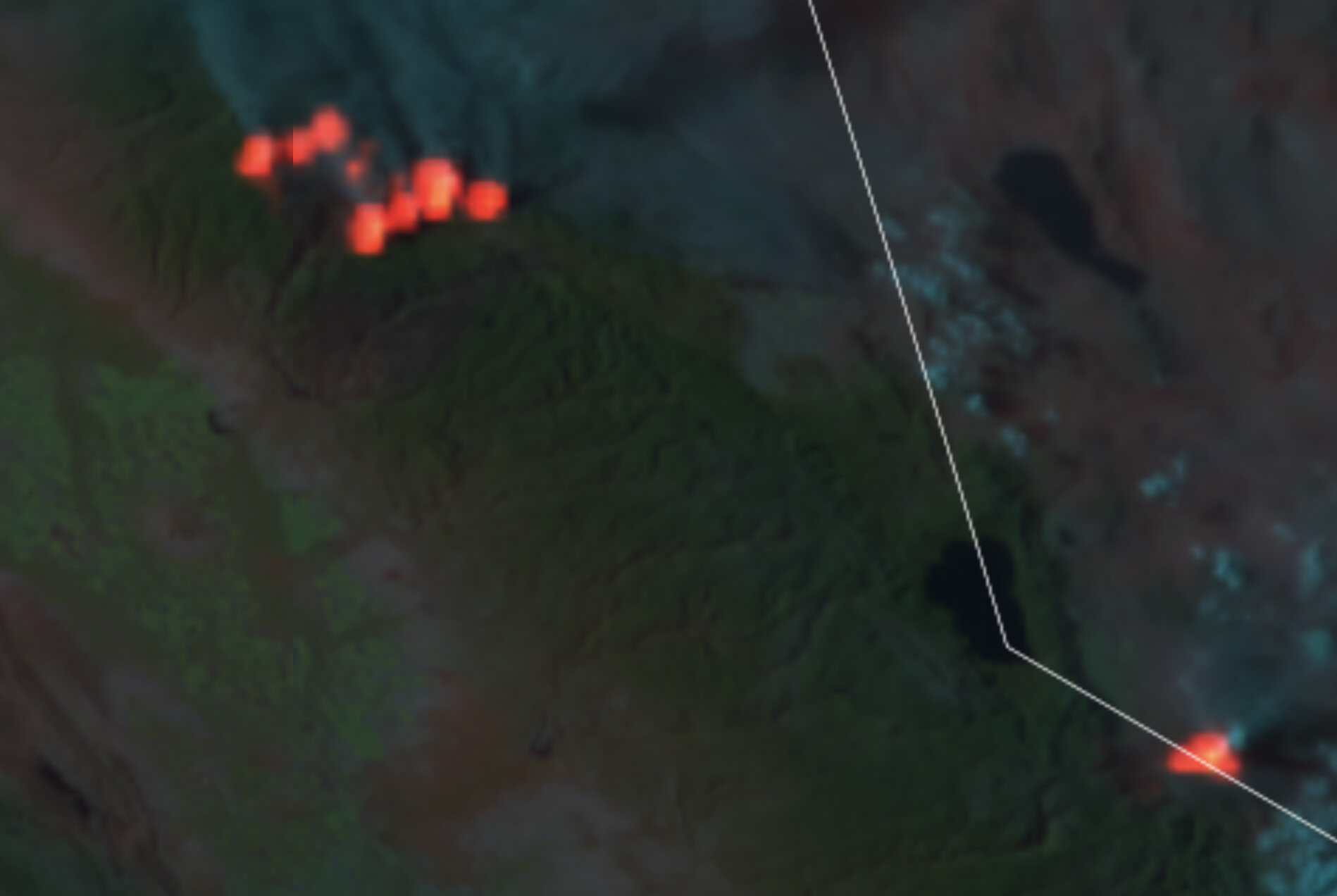
Viirs is showing Fly and Dixie have joined across Indian Creek. Also showing a spot east of the head of Fly fire. IR flight tonight will be interesting.
4 Likes
Sounds like 32 is closed for preparations for a firing op in the next 24-48hrs or so? Not much details other than some possible hail mary plans to somehow (dare I say “tie in”) 89 to roughly 32. Still looking up details and intel.
This firing operation is also the reason for pulling the trigger on Evac Orders for Butte Meadows area. There are a few small spot fires a bit ahead of the main fire, but otherwise Butte Meadows is not in immediate threat of the main fire at the moment. I think they want a buffer of life safety around this whole thing if they go with their plans.
10 Likes
Those look like artifacts from the satellite scanning the column. The linear pattern and even spacing are usually a clue.
7 Likes
NIFC portable repeaters are .50uv rx sensitivity (poor for HT) and 10 watts PA (poor for HT users to hear) into 1/4 wave length mobile antenna (not a repeater base station antenna). I placed many of these on each complex fire for multi overlap coverage and looking up/down canyon on almost every ridge. Kinda have to have many repeaters to make it all play across the incident. Boise cache used to always bug me about that. Good coverage = Safety for the forces on the line.
Now they should figure out how to make all the logistical traffic have there own repeaters.
6 Likes
Tonight’s Dixie Fire briefing meeting featured presentations from both the West zone and East zone of the fire – so there was something of interest for all of the residents of Butte and Plumas counties affected by this fire, which as of tonight has grown to 167,430 acres, is 18 percent contained and has 4,266 personnel assigned to it. The Fly Fire that established itself yesterday near Keddie in the Feather River Canyon is 3,800 acres.
he area has entered a warmer, dryer weather pattern with temperatures set to increase over the weekend. Humidity has dropped and it’s significantly dry, Winds will continue from the southwest during the day, albeit not as strong, with a northeast flow increase in the evening.
The northeast flow will continue this evening and canyon winds will be enhanced. The pattern continues tomorrow, but by Sunday mid-level moisture moves in that allows the extra tall white clouds to grow on top of the smoke columns. The smoke columns have the potential to influence the fire behavior.
The bulk of the fire’s movement came from the spot fire that established itself near Twain two days ago. The second most fire activity had to do with the Fly Fire, where crews are going direct, trying to keep it out of the Mount Hough area and Highway 70 corridor. This is the fire that has all of Quincy on evacuation warnings. He explained that the fire got its name because it started near Butterfly Valley. When dispatch receives the report of a fire they name it based on where it is geographically located.
Reporting for the West Zone, Mike Wink said the left flank is holding in the containment line. But the area toward Butte Meadow, Snag Lake and Jonesville presented problems yesterday, and crews are building indirect line on this.
Working the area of Butt Valley Reservoir, crews went back to Canyon Dam and picked up a road system. They were able to do a firing operation which paralleled Highway 89. “Folks in the area saw the fire’s edge pretty close to Highway 89; that was us doing backburns.”From Butt Valley Reservoir to Caribou, crews are trying to box in the fire and work down to Highway 70.
A combination of Dixie crews as well as the Plumas National Forest responded. By the end of the evening yesterday the fire was 1,600 acres, then 2,100 acres; now it’s 3,800 acres. The fire has not spotted over Mount Hough.
Bucks Lake containment line is mopping up and secure. He is confident Bucks Lake proper won’t be impacted.
Mike Wink provided an update for the Chester area and said that most of the fire spread has been to the north and the east. “For right now Chester is not having fire spread,” he said.
Prattville has black line below it. While there is fire several miles away, nothing is spreading quickly toward it. Both zones have groups identified for surge resources. Yesterday when the Fly Fire started the surge crews were diverted there.
There are 18 inmate hand crews on the fire.
21 Likes
Thanks j nice to know we have ir on dyer. I live in Dixie Canyon right under Indian Ridge right in the middle of this mess, Apparently the plan is to fire 89 and Dixie Canyon Rd.
1 Like
How do you get the link to the briefings?
3 Likes