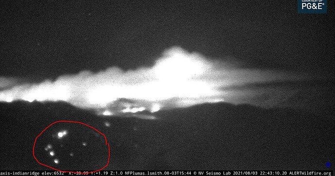
Seeing this on the Indian Ridge Camera. Is that active spotting just above Moccasin?
http://beta.alertwildfire.org/region/tahoe/?camera=Axis-IndianRidge
Couple patches of Logs and snags well inside the burn perimeter.
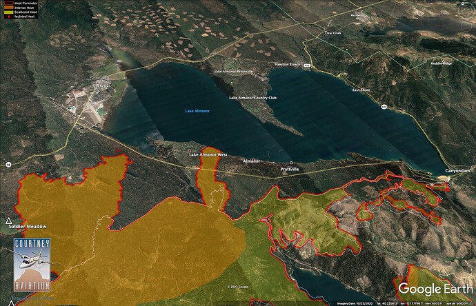
Posted IR maps here,with some analysis: Dixie Fire – 8/4/2021 – The Lookout
This is the first post on a new website I am firing up!
Thank you for your hard work. Learning a lot from your posts.
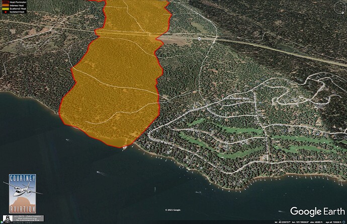
Haven’t figured out to start a subject on this board, but maybe you have some intimate info on what is happening near Lake Amanor. I haven’t seen any posts about large structure loss in LAW or anywhere else in the last days since the fire hit Greenville. To me, this is good news, because if they had lost a bunch of structures in LAW we would probably heard about it this morning. I’m sure a lot of landowners are holding their breaths waiting for word to come out how the fire is doing in the subdivision and if there was major structure damage. The fire had reached the south end of the subdivision last nite and should have impacted structures by now.
I don’t have any on the ground intel, just going off the IR and talking with my brother, who is in Indian Valley. The IR shows a glancing blow of the new finger of fire hitting the Lake just east of LAW. It hit the Lake about sundown, based on photos I saw, and the IR is from 1:30 am. Like everything with fire, they were lucky this spot didn’t get rolling a half mile west of where it did.
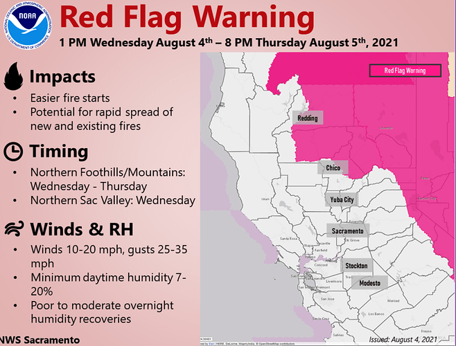
I’m a bit concerned about wx change coming up, with forecast of switch to strong west winds tmrw afternoon - lots of new flank that could become the head and run east tomorrow.
IR imagery from 8/4/21 - 01:30 hrs
Is there a unified source for past/present/planned air attack? In particular I’m interested if there are ongoing air operations or any planned, aggressive air support to stop this mess on the north before it crosses 36 and rolls up into Lassen National Park. Thanks all.
I don’t know what their plan is, but from what we’ve seen past couple days, air support is pretty ineffective against long-range spotting when you look at the sheer scale of the fire. We’ve got about 25 miles of new uncontrolled perimeter following the past 2 days of spread, and least a 3rd of that could be considered the head depending on which way wind is blowing. There is a spot a mile north of Highway 36 this morning. Not much tankers can do under these conditions. We may have some success on the flanks here or there but this fire is beyond control until the weather cooperates and we get socked in with smoke again. Then it will get up and run again when the lid comes off. I think it is really important we are honest about this with the public.
Fair enough. I appreciate the honesty. The most recent containment strategy clearly did not work. That result may have been driven primarily by exogenous factors (clearly weather among them). However, regardless of factors within or outside our control, the results have not been encouraging. Are we modifying the plan or doubling down on the same strategy?
Quick opinion inserted, I think the containment strategy on this piece of the fire was solid and nearly complete. One ember over the line is all it takes. With the current fire/weather/fuel conditions, Fire fighters have to get it right 100% of the time, the fire only needs to be right for 1 spark of the time.
edit: and the strategy is made to fit the circumstances of the moment. In this last strategy, the terrain, fuels, road systems etc allowed for dozer and firing operations to try and stop the spread. Further north, the strategy might change to ridge system dozer lines, firing ops, get-out-of-the-way-so-I-can-go-home-and-hug-my-kids, etc. There is no single strategy at any given moment…dynamic.
I agree with what you say about the weather and the fire missing the subdivision by a little south. This would indeed have been more of a problem if it had come into the subdivision spotting all over the place. I was up there a couple of weeks ago and a lot of people had already stacked their winter firewood near their structures. I hope crews staged in around these places have found ways to mitigate that hazard and also hope they are steering the fire around the bulk of the houses while the weather is conducive.
There are still 44 LG/OES strike teams assigned to the Dixie.
Since there are many new folks to the board, please permit a little grace in a longer description. Many folks do not realize that the “Air Attack,” which is a term being shied away from when ICS went All-Hazards, is technically part of the Air Operations Branch who works for the Operations Section Chief (OSC) like all the other operational branches (OPBD). The platform in the air is the Air Tactical Group Supervisor (ATGS) who is responsible for carrying out the air portion of the OSCs strategy. The ATGS should not be doing their “own thing” but coordinating the air aspect to compliment the ground portion of the OCSs strategy. On active fires (high flame length/fast moving) the ground forces can’t do their job very well until the air support mitigates some of the intensity, but inversely, an air operation requires ground forces to finish the job. As for the “past/present/planned” plan, after morning operational briefing it is quite common for the ATGS to call the oncoming OSC and talk about strategy and priorities for the operation. During the Operation, as the situation and priorities change, they talk in order to stay on the same page. I always preferred the Cphone because I need to say stuff to him/her very candidly. Whether you agree with the analogy or not, firefighting is very similar to war. It is far more complicated than the public realizes and there is a lot of “fog of war” when the enemy really gets active and comes at you from several fronts. You have to make choices with limited information, not always vetted the way you’d like it to be, but trust me, a 70% plan now is better than a 100% plan after it’s too late.
There are several OES Crews that are switching out with crews that are timing out too.
I agree; it worked until it didn’t. So many variables are included in what fire does and situations can change at a moments notice. Nothing is certain until the fire is “dead out”.
the game aint over till the fat lady sings.
This should be required reading prior to posting, kinda like the “I agree” button. Very well stated, and a lot more succinctly than I would have.
The weather this AM at the Humbug RAWS had the RH as low as 8% and as high as 18%. The FBAN talked about the FDFM(Fine Dead Fuel Moisture) being 2-3%. That translates to 100% Probability of Ignition if an ember gets into that fuel bed. Finally, the runs the fire made the last 2 days, were of a nature of that found in Chaparral & Brush not timber. But another way, it would be like talking a match to an 8" log in your fireplace, touching the lit match to the log and the log ignites and instantly begins to free burn and build instant heat without the use of Paper or kindling.
I keep hearing the plan failed, they should do this and they should do that. You had over 6000 people working their ass off for the plan would not FAIL. How do you think these crews feel going on three weeks now. You don’t think they are a little frustrated about now. Everyone out there wants to put this to bed it’s a big pride thing! We were burning brush fields off at the end of April in the motherlode. What’s that tell you about these fuels and how receptive they are. What have we had three or four big heat waves since then. I was lucky worked and fought fire on both the west and east sides on the mountains. You think the west slope is dry take a good look at the east slope. It’s most likely been dryer but my 30 plus years this is the driest I have ever seen this early. That goes for both slopes. The last thing we want to do is put anyone in jeopardy may it be in the air or ground unnecessarily.


