Bookmark for future reference.
also the link for access to IAP’s, GIS, and IR maps have been posted multiple times. You can find them in this Q&D, Continuing, or in the General Discussion Section
Bookmark for future reference.
also the link for access to IAP’s, GIS, and IR maps have been posted multiple times. You can find them in this Q&D, Continuing, or in the General Discussion Section
Heard they said in the nightly update it was 300ac
I have been keeping track of the links previously posted here and in the continuing incidents. ATAK had no IR update today. The link you posted was from 7 am and I can’t find anything newer there, so that was not helpful at all. Maybe you can help guide me to where in that link it shows or references the 50 acre spot/slop over(whatever it is) south of Beardsley Grade near Kessler peak?
The post I asked about referenced a recent IR. Was it the VIIRS? A fixed wing flight?
It means a lot to me as the cabin that my wife, daughter, two sons, some great friends and I built is in imminent danger.
#DixieFire - 8/17/2021 Evening Update
New detailed heat maps of firing operations near Westwood and in Lassen Park, firing on Beardsley Grade, fire history and what it means for firesafe communities, minimal spread toward Janesville and Susanville, and tough calls for fire bosses. Dixie Fire – 8/17/2021 Evening – The Lookout
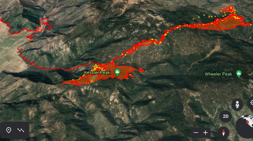
Open that first kmz file with Google earth you will see significant heat south of Beardsley almost to Kessler peak. I assume Beardsley was the control line with dozers straightening the curves
Is your cabin in franks valley?
this was a fixed wing flight from courtney at 17:51
From what i can tell beardsley grade crosses north of Kessler peak? If so yes fire has crossed the grade and up to the peak with some extension to the south side of the ridge east of Kessler peak
Thanks. I haven’t been able to see that until you mentioned the google earth part.
My parents own a cabin in Mill Creek. I don’t think it will be standing by the end of today if it even still is now. Several reports about Mineral evacuating but I haven’t seen anything yet for status on Mill Creek, probably because they are summer cabins and not primary residences.
Community meeting comment was for 50 acres. But looks much larger now. Things not looking good…
Right side it blew across Frank’s Valley.
Left side is where it has grown around Kessler peak.
We were evacuated from Bucks Lake, those are mostly summer homes also.
Yep. Seen that. Another 24-48 hours to see what it does with the N/NE winds. Have been gaming the worst case scenario for 2 weeks now about having this thing do a 180 and come back over Grizzly ridge toward Quincy…
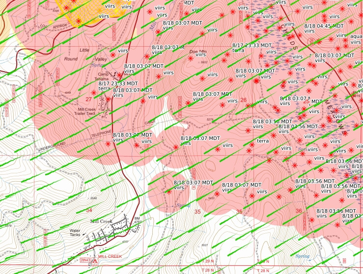
This morning’s IR shows it over Hwy 36 at Childs Meadows. I’m curious how far it will push into the frontcountry like Mill Creek/Black Rock.
Same fear I have been having. Genesee is about 9 miles from the eastern portion of Quincy/Massack/Greenhorn. The wind is heading that way until around 8 PM tomorrow evening when it will switch back to the common W/SW flow. Hopeful 9 miles is enough of a buffer for those areas, at least for this round of wind in that direction.
Wait what. They out fire on the ground around the visitor center at the park?
IR already stale as usual. Satellite heat signatures put it very close to Mill Creek structures and almost 1/2 way down off Beardsley Rd. toward Genesee…
They quit working on the secondary line atop Grizzly Ridge long time ago. Probably not enough resources to go around now to start it up again.Barely have enough for Genesee…
The WX PGE Hwy36 station is right at Childs Meadows where NIROPS from 835pm Tuesday night shows it crossed. That station took some sustained 20mph with gusts into mid 40’s late last night.
I’ve been watching this closely through the night and morning with the wind event. The VIIRS is interesting since the Stump Fire last year took a lot of the easily burnable fuel out inside that pocket. A lot of timber still stands there, likely extremely stressed, but I have not seen any GOES heat progressing like you’d expect with the winds. I think it’s stopped and the VIIRS is smoke column heat or ground fire that they could jump on and we avoided a crown run. A lot of that opinion is relying on the GOES data. If that had gone wild, we’d be seeing heat progressing south very quickly.
The current heat is all in the unburned pocket of Feather River Meadows up around Wilson Lake and Blue Lake Road, where they fired off the very top to stop this at 89. The unfortunate side affect of that is introducing fire in a critically strategic place they need to hold to keep it out of Mill and Deer Creek canyons and racing to the valley floor in a matter of a few hours. That’s one of the major puckers BTU has at the moment.
Hamilton Mt cam about to get hit
Contingency lines were being planned yesterday for Grizzly Ridge.