Some long weeks ago I said I wouldn’t be surprised if it burned around and eventually hit the Beckwourth complex. Well I’m not surprised but shocked, awed and saddened. It may be just rapid oxidation but it seems like it has a, rather nasty, personality.
But gotta say I appreciate all the fire fighters and I’ve seen fire engines parked here from BLM, Paradise and Alameda and local of course. This sure isn’t the old days.
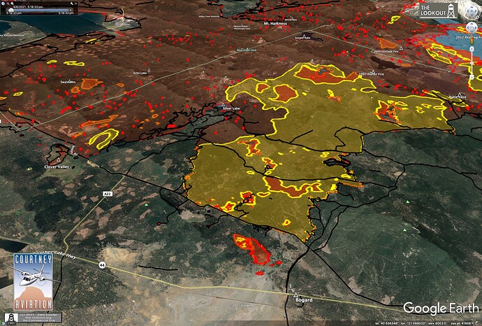
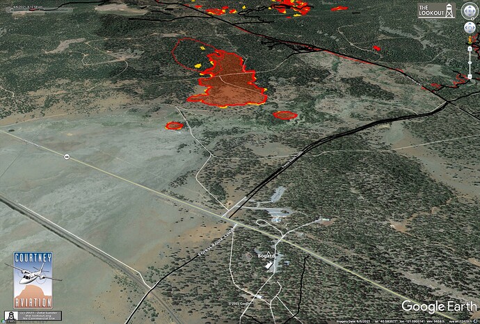
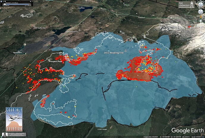
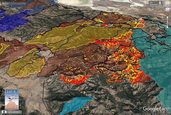
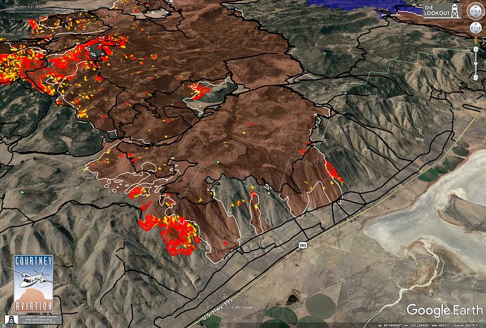
The SE side of the fire added about 8,000 acres, fire was spreading slowly down Escarpment. A 30 acre spot took off west of Bogard, and fire got up and ran a mile in the 2012 Reading Fire area. Maps and writeup on The Lookout.
Great description of Mastication.
I’ve noticed they mow the brush and don’t leave behind any debris on the gas pipelines out in NV. I assume it’s an intensity reduction thing because it leaves low brush which would help in erosion prone areas. Looks good though not sure how useful it would be in mixed brush forest areas.
KML files for 09/06 added to my post for 09/05:
Yes it was! I’m curious why they often toss a piece of plastic or tarp on top that only covers a fraction of the pile, then deteriorates and pollutes the ground?
So you can have a dry spot to light it when it’s January and super wet out.
Obviously they aren’t supposed to end up on the ground or blowing on the wind but it happens. Supposed to be weighed down by the top 3rd of the pile
Anyone know if they were able to pick up the spot that was near the Bogard Rest Area today?
I can’t answer that but 44 is closed all the way from Old Station to A-21.
HWY 44 is now open.
Ah!I went to click on the CalTrans Quick Map closed symbol and the page refreshed itself. thanks for the correction.
Small piece of 395 is closed down near Herlong. Traffic is being diverted via the Herlong access rd and returning to 395
Update: Traffic is now being stopped in Janesville and Garnier Rd in Herlong
The wind pushed it off the escarpment.
http://www.alertwildfire.org/shastamodoc/index.html?camera=Axis-ShafferMtn&v=fd40730
Yes sir. Had a good view of it as I passed by
Looking at the 5:20 pm IR, the spot fire near Bogard ran about 120 acres this afternoon, had 2 three acre spots about 1/4 mile in front of it, was about 3/4 mile from Bogard Rest Area. Looking closer at the IR last night, I noticed the spot that ran 30 acres yesterday (9/5) was actually mapped on the 9/4 NIROPS flight, so it must’ve escaped after they worked it earlier on 9/5 - it wasn’t a new spot yesterday afternoon.
The fire in Lassen Park, within the 2012 Reading Fire area (light blue) looks like it made a run which merged with a new firing operation which is using the Pacific Crest Trail along with dozer lines to try to check the fire’s northward spread. The area along the north side of West Prospect Peak which was fired unsuccessfully last week (too green to carry well) looks like it has cooled off, don’t really see much heat there at all.
The SE end of the fire looks like it ran another 8,000 acres from where it was mapped last night. 2021 Beckwourth Fire is light blue, as is (smaller) 2021 Dotta Fire.
As of 5:30 pm, fire was still coming off Escarpment in fingers.
Shout out to @tornadokat for making the dozerline and hand line KML overlays, saving me about 250 mouse clicks!
@pyrogeography
You’re welcome! Do you need hand lines broken out by themselves? Currently I do dozer lines because people seemed specifically interested in those, and then all types of lines lumped together:
‘Completed Burnout’
‘Completed Dozer Line’
‘Completed Fuel Break’
‘Completed Hand Line’
‘Completed Mixed Construction Line’
‘Completed Plow Line’
‘Completed Road as Line’
My KML files for 20210907 added to my ever growing last post here:
I think the way you are doing it works well. I like to show dozer line on maps, and having the rest of the line types as a KML is handy for interp in Google Earth to figure out what is going on.
About a week ago someone posted a tool enabling one to “tour” the forest/landscape post Dixie(Zuula??). My sister is quite fearful of returning to her cabin in Lake Almanor because of the loss of surrounding areas that she and her husband have loved for so many years. I thought it would help soften the shock. In particular I remember Chester, Canyon Dam and Warner Valley. I was wondering if there was anything for Big Springs/Yellow Creek Area? Our parents ashes are near there. Thanks in advance.
And of course thank you for all your hard and brave work! This forum has been most helpful to me throughout the years having myself been affected by several fires. BEU Asst Chief Matteson and y’all taught me most everything I know.


