DC10 just dropped on it. Must be Making them nervous to bring the big boys in. Winds have picked up and are gusting around 20 mph. If it has spotted back across the canyon the diurnal (sp?) winds may cause a problem later . It must be getting closer to the top of the ridge. in the 15 minute loop you can see they just dropped retardant maybe 100 yards in front of Sunset .
2 Likes
Three VLAT’s, and an assortment of other tankers, have been dropping on it for a week, except when hampered by poor visibility.
2 Likes
They have been dropping enough retardant on that area to paint it solid red the last week. It just does not seem to be doing the trick so far. Winds come up in the afternoon and it takes off again
1 Like

picking up the plume off bloomer now. looks like two different sides of the ridge

Sunset 2 has refocused on a new spot
you have the DC10 and the 747 following each other into the area
2 Likes
Anyone else catch that mid-slope spot (at the 14:34:20 mark) before they moved the SunsetHill2 Cam?
http://www.alertwildfire.org/shastamodoc/index.html?camera=Axis-SunsetHill2&v=81e004f
Edit: Zooming in on the pic, looks to be along a road.

4 Likes
no, nice catch. that area looks like it is in an burn scar? wind is all over the place. hope they see it as well before it gets legs and runs 

2 Likes

That spot is about 3/4 mile inside the line. The dozer line cutting across the yellow circle is the fire line on the ridge above Sucker Run Road. That entire drainage there also burned very hot in the 2017 Ponderosa Fire, which is the scar you see in Google Sat View. It’s also closer to the creek, so probably some wetter green that is smoking now that it has some great solar heating.
5 Likes
Thanks for the detailed info, Jake.
3 Likes
That goes back to a previous thread talking about showing caution when using the cameras. Don’t give a 952, unless you are 10-97, (talking old CDF guys language) based only what you see on the cameras. The cameras have proven to be deceiving at times.
10 Likes
They painted closer to the Sunset comm site tonight before pumpkin. One drop was direct on the fire heel of smoke, quite a distance and the camera still got misted from the wind intensity. Winds tonight should flank, slightly shouldering the site, closer in direction of site than this afternoon’s winds. However it looks like tomorrow night the winds will be down canyon for a little while, turning flank to head.
I’ve been in contact with some of the techs with the site. One vault and tower will be just fine. Another small one will definitely get hot if they don’t prep. They were thinking of pulling some gear out tonight or tomorrow to avoid loss, considering they are non-profit but still public safety. West Zone COML was notified and hopefully he can pull some strings to support this critical infrastructure supporting the law enforcement mutual aid for that entire area.
There’s clearance, and a backing fire would be fine except for some coax runs. But some deciduous trees by the smaller vault could pose a problem if it got too exciting up there.
7 Likes
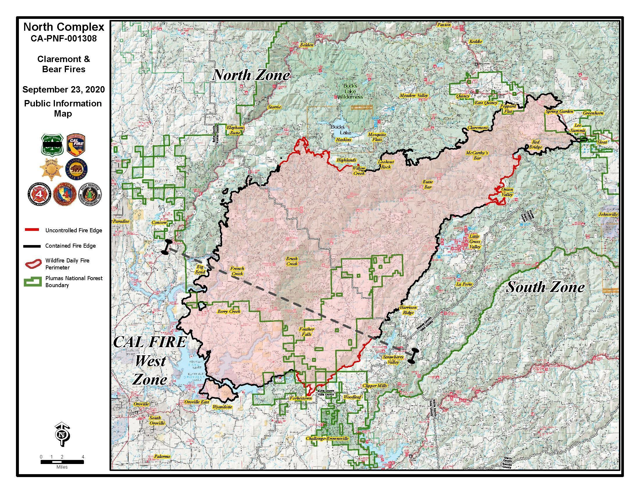
Current Approximate Acreage: 301,404
Approximate Containment: 75%
West Zone
*WEST ZONE - 82,500 acres- 63% contained
Looks like it is mainly being worked from the air by helicopters today. Have not seen or tracked fixed wing aircraft yet this morning. Darker smoke today .

2 Likes

afternoon winds are picking up over the area
PGE is now calling for a wind event. Saturday afternoon thru maybe Monday morning. Area may be in line for a PSPS (Public Safety Power Shutoff) again. Temps also are predicted to be in the lower 90’s and NOAA is in a fire weather watch status for the weekend.

6 Likes
Anybody know what’s going on here?
Sounds like Calfire is firing off of the road to Sunset Lookout.
3 Likes
The winds came up mid afternoon and it looked to take off. On the Sunset camera in the time loop you can see they are working around the towers getting ready .
3 Likes
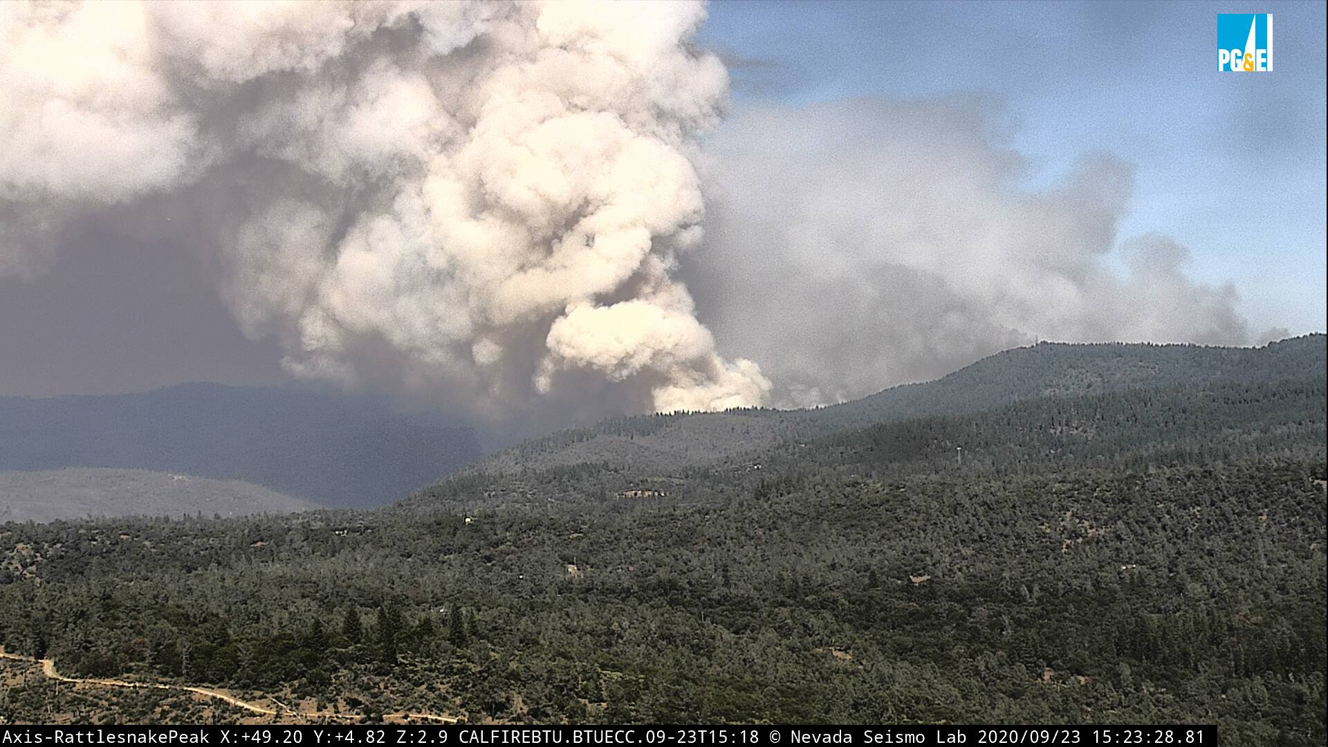
Huge air show yesterday. They painted lower Forbestown road area all day and conducted a firing operation last night. Today the firing operation continues in the Forbestown with a goal of tying it into the Ponderosa reservoir. Heavy timber lots of drainages so it’s obviously putting up a good column. Div D and F have been working their butts off trying to stop this thing.
9 Likes
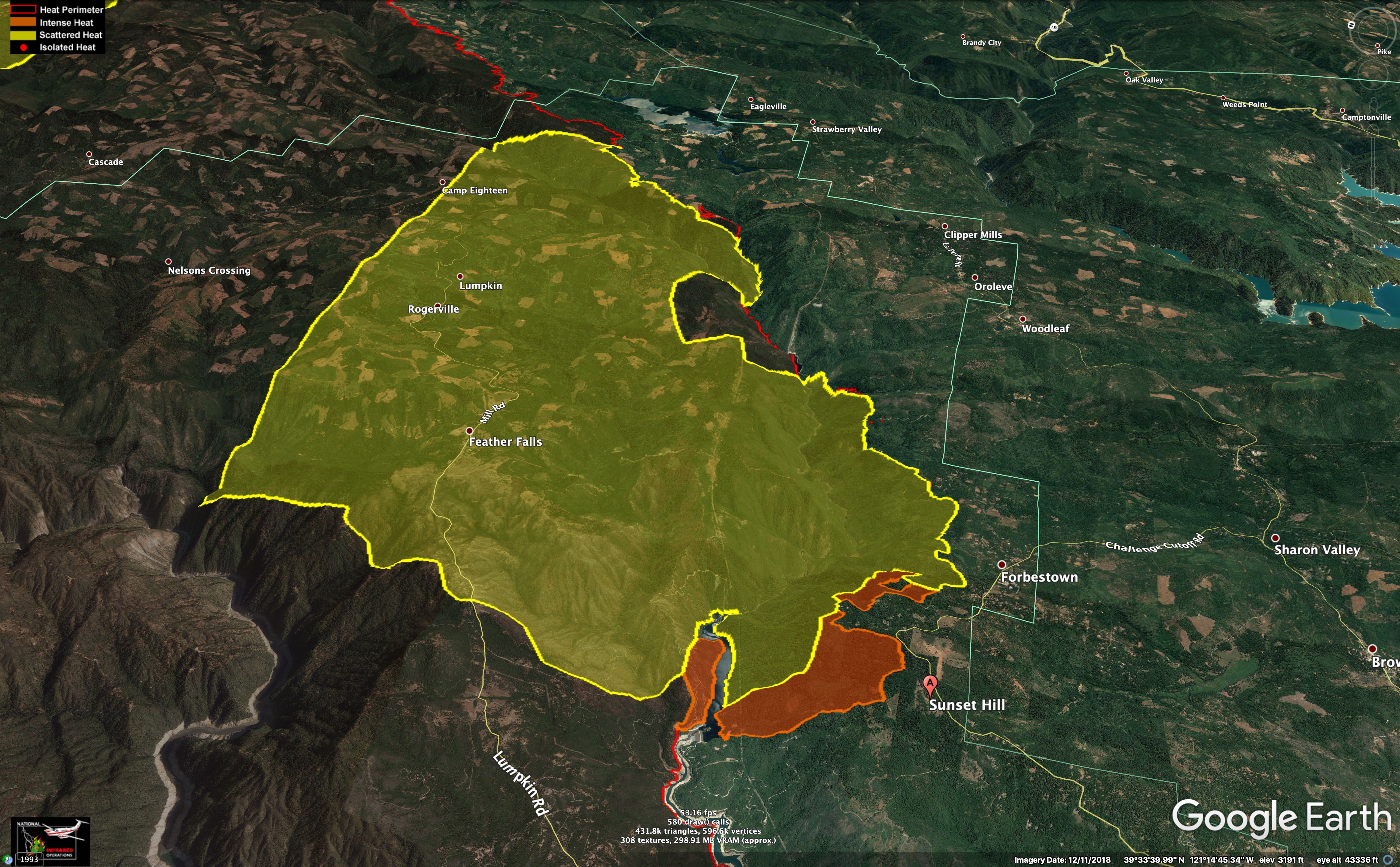
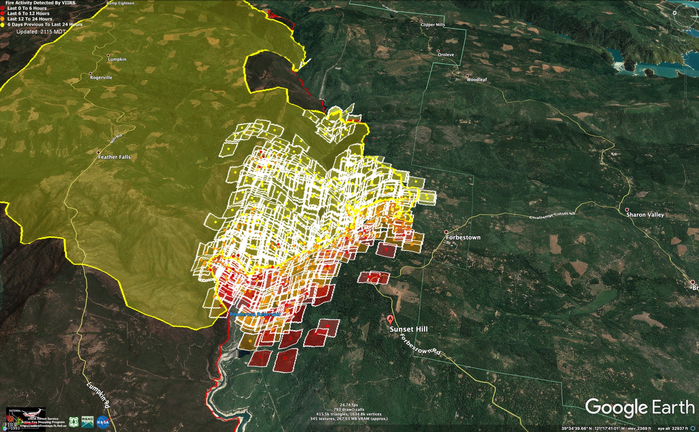
Here is last night’s IR with today’s VIIRs (around noon), looking east.
The VIIRs hits closest to the viewer, and next to Forbestown Road are suspect.
Pretty great view of the fire behavior over the course of the afternoon on the Sunset cameras.
http://www.alertwildfire.org/shastamodoc/index.html?camera=Axis-SunsetHill2&v=81e004f
Cal Fire has had a tough hand to play with this firefight.
What have the downcanyon night winds been like on the South Fork Feather?
Good luck, everyone.
Here is a satellite view of the fire about 2pm on 9/21/2020.

On a positive note, it looks like a bit of the ground between Forbestown and Feather Falls burned after the initial wind-driven push of the fire has had low to moderate severity fire. Here is an image taken 9/21/2020. Green is intact foliage. Everything left of red line has burned.

7 Likes