ST XSJ 4177C enroute. 4 engines from XSJ, 1 from XTB.
Another bad situation.
1 Like
This beast is heading straight to a lot of people who are sleeping right now.
New evac orders
1 Like
Red Flags going up into TCU now
3 Likes
A Red Flag warning, ie: extreme fire weather, was forecast originally for the north state north of Plumas county. They updated that tonight to extend down in to the Cal Fire Tuolumne-Calaveras Ranger unit. This includes the area of this fire
https://www.fire.ca.gov/programs/communications/red-flag-warnings-fire-weather-watches/
2 Likes
Fire appears to be banking down some and evac radio traffic has died way off. No panic calls either for at least an hour.
3 Likes
DATA PACKAGE POSTED FOR THE CALDOR. MAPS.TAKSERVER.US
ITS ONLY AN OPS MAP. NO IR POSTED.
BE SAFE EVERYONE.
4 Likes
XSA just punched out an IA T3 strike team 4151C
CSM
FOL
SAC
SAC
SCR
3 Likes
6500 acres per Inciweb
2 Likes
Yeah, I don’t know if I buy that. I;d be shocked if it was that small. Local estimates were running close to 10,000. We thought an inversion layer was setting in but it’s popped.
ALERTWildfire | Tahoe
1 Like
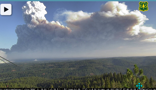
Based on “Armstrong Lookout 2” camera time lapse for the last 15min - 1hr, the Caldor is cranking early. ALERT Wildfire
8/17 Ops Map ***(take with big grain of salt, 2,257 acres is older data considering current conditions)

Unfortunately that map looks to be dated and not accurate.
Yes very much so but for folks not familiar with the area, you have to start somewhere. It will take a few op periods to get caught up with a more accurate map.
1 Like
Yeah, the fire is a lot farther north now. It jumped into Grizzly Flats across the Steely Fork at the top of that map sometime around 1am-ish? Like you said, it will take time, likely until the type 1 team gets in place.
2 Likes
Spot fire to the south of the big header. Looks like it occurred around 3 am.
5 Likes
Ya, that map is prehistoric. It’s burned off the top of the map.
3 Likes
Weather concerns from this morning’s Inciweb update:
“Hot and dry weather will continue over the fire early this week. Winds are expected to continue increase throughout the week. Forecast winds over the next 3 days have been associated with
aggressive fire growth and runs of 3+ miles are probable in the absence of an inversion.”
1 Like
South Sly Park area has just transitioned to a mandatory evacuation order. It includes everything from E16 (which is Mt. Aukm and Sly Park Roads) to Jenkinson Lake.
2 Likes
From the scanner - Law Branch communications. El Dorado County doesn’t seem to put the evacs anywhere on the web. They do ultimately show up on Cal Fire and Inciweb, but it takes quite a while.
3 Likes