NEU East just toned out S/T Charlie 9231 (sketchy reception…not 9031 as originally posted)
Eng 2396, 2356, 2386 plus ones I missed.
NEU East just toned out S/T Charlie 9231 (sketchy reception…not 9031 as originally posted)
Eng 2396, 2356, 2386 plus ones I missed.
Confirmed via CHP, Closed both ways to Pomo Rd (round about) in Myers
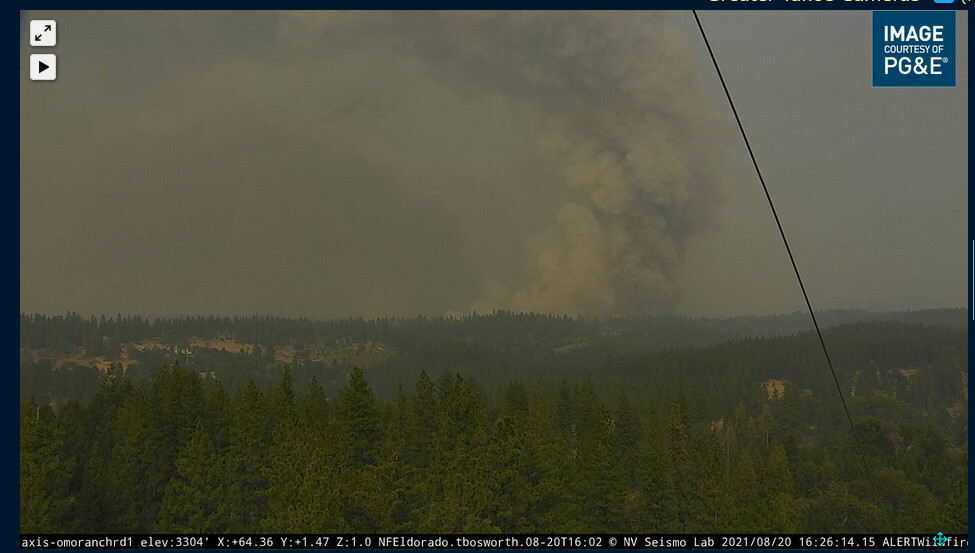
multiple columns building as visible from Armstrong Lookout2 (best viewed 1 hour time lapse)
http://beta.alertwildfire.org/region/tahoe/?camera=Axis-ArmstrongLookout2
Helco Ops diverting for imminent structure threat as fire is soon expected to crest the ridge. (Didn’t catch the name of ridge)
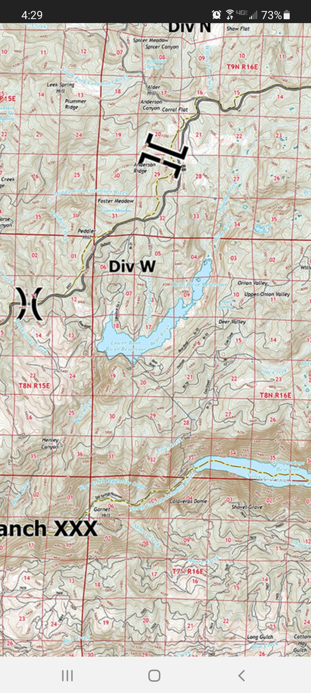
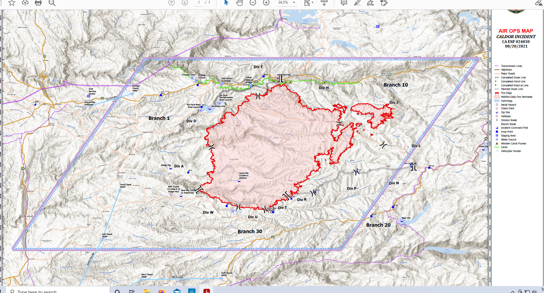
Division Whiskey…looks like lower Bear Reservoir area
Looks like it took off about 1/2 hour ago.
http://www.alertwildfire.org/tahoe/index.html?camera=Axis-OmoRanch1&v=fd40737
Last I heard this fire is nowhere near Lower Bear Reservoir, which is south of Hwy 88, east of Pioneer. Please check your source and revise your post if need be.
Good view on 1 hour tlapse
http://beta.alertwildfire.org/region/tahoe/?camera=Axis-Leek
From the chp cad page
Detail Information
4:18 PM 7 [19] *** AT 1630 HRS EB 50 AT SLY PARK WILL BE CLOSED AND WB 50 AT MEYERS/POMO WILL BE CLOSED ***
4:05 PM 6 [17] 13-S3 50 BEING CLOSED ON SLT SIDE AT MEYERS CHAIN CONTROL AND NO PARTIES WILL BE ALLOWED PASSED CHIAPA // PVILLE CLOSING DOWN ON THEIR SIDE ALSO // EDSO WILL START EVACUATING FROM ECHO SUMMIT TO THE WEST
4:01 PM 5 [15] 13-301 ENRT TO MEYERS CHAIN CONTROL CLOSURE
3:54 PM 4 [6] [Appended, 15:57:35] [1] PER 13-S3 SEND 101 TO TWIN BRIDGES TO ASSIST D1 W/ CLOSURE AND SEND 301 TO MYERS FOR CLOSURE
3:08 PM 3 [4] EDSO ADVS VIA LL NOT PROVIDING ESCORT TO PEOPLES RS
2:58 PM 2 [2] REQ TO CONFIRM CT AWARE TO MAN CLOSURE AT MEYERS CHAIN CONTROL
2:57 PM 1 [1] 13-S3 ADV 50 WILL BE CLOSED DUE TO FIRE
Huh? The Armstrong Lookout cams are looking north. Bear Reservoir is south. Div W is at the heel of the fire in the area of Omo Ranch. The fire activity in Div W is visible on the Omo Ranch Rd 1 cam.
Not sure where you heard that, they are currently dipping out of Lower Bear reservoir.
Heard them talking about Div Whiskey and based on this map someone posted on here, Div Whiskey is near Bear Reservoir
Ok, it’s the pie effect on divisions. Activity might be in Div W, but Div W does not extend out that far (yet  )
)
Looking at the map from today, division Whiskey is no where near Bear Reservoir…my apologies for not using a more updated map !!!
The letters “Div W” are on the map near Bear Resivor. The actual fires edge in Div W is much farther west.
Heat intensity with wind vector and velocity layered on
It is nowhere near lower bear is miles from it…
Per Caldor Fire Ops radio
5 helcos working Whiskey
2 Helitankers working Tango
Several more on order
75,845 acres and 5% contained.