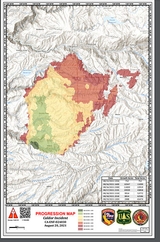
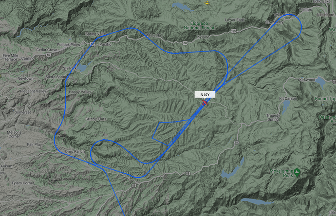
As far as I can tell, it did. Google map with IR from about 6pm today.
This feed is streaming the Caldor incident now. Some radio traffic so far. The other feeds are down as of now.
Looks like an IR flight happening now. FYI the blue line does not represent the perimeter of the fire. Not much other aircraft on the fire at the present moment.
Fire watch 51 based on scanner traffic. OPS had him look at Division A and D as priority…
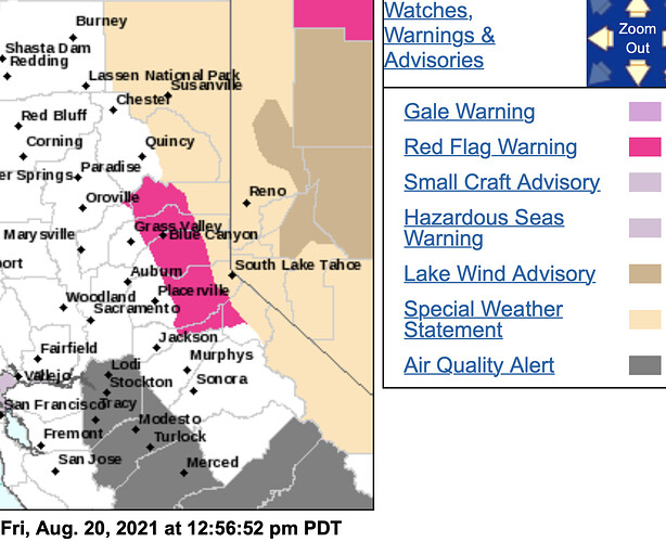
URGENT - FIRE WEATHER MESSAGE
NWS Sacramento CA
1254 PM Fri Aug 20
…Red Flag Warning on Saturday for the Vicinity of the Caldor
Fire…
.Southwest winds will increase Saturday morning, continuing into
the early evening hours. These winds combined with low humidity
and continued extremely dry fuels could cause critical fire
weather conditions in the vicinity of the Caldor Fire
…RED FLAG WARNING IN EFFECT FROM 11 AM TO 8 PM Sat.
-
AFFECTED AREA…the vicinity of the Caldor Fire along the western slope
of the Sierra Nevada. -
WIND…West to southwest wind gusts of 20 to 30 mph, locally up
** to 40 mph in favored gap**s, canyons, and higher elevations. -
HUMIDITY…Minimum humidity of 20 to 30 percent.
-
IMPACTS…Potential for rapid spread of active wildfire.
We need an “ugh” button or something like that. I’m glad you posted this. It’s important information. I just can’t bring myself to click the “like this post” button though!
Not going to be a good weekend in Tahoe. Please tell all the tourist to stay home.
Im at the bottom of 88 @ 12 and visibility today is bad. No Delta breeze today. Smoke is really settling in this afternoon. Calm before the storm? I hope not.
Looks like the winds have already switched direction. Westerly flow has started. Leek Springs Camera shows smoke moving towards the east now.
For those who live along pleasant valley Rd, sly park hills, or in Pollock. School district cancelled school till Sept 7th after talking with fire officials. Inferring that Mando evac and sealing off of roads to area could last for another week or more. So displacement could be for a while longer
With the fire heading east today, is it too premature to discuss South Lake Tahoe? Tomorrow looks like perfect conditions to travel over the Sierra with 40 MPH gusts and even stronger on the lee. Does the wind bend north with the canyon in the Highway 50 x 89 area?
Any one have any intel about it crossing the middle fork south of pipi? There’s a copter looking like it is dong a lot of drops there.
I don’t believe it’ll get there, the rock and much thinner fuels over the crest will slow progression. The smoke cover will also cause the fire activity to be diminished some. The winds tend to be channeled by the terrain and most of the drainage’s go away from Tahoe, except of course the south fork of the american. this front is not nearly as strong as the event that caused the big growth day, plus the humidity will be higher as well.
The big granite up there would be a great place to hold it.
The likelihood would be very low to spill into the basin, but who is to say for sure anymore.
Evacuation orders now all the way to twin bridges and evacuation warning all the way to Echo Summit.
As I recall, they had a significant contingency group in the Tahoe Basin during the King Fire in 2014. Of course they also had over 8,000 people assigned to that fire. Looking at the winds and topography this morning, it did cross my mind that this thing could make a push for the summit, though not necessarily all the way into the basin. The northeast corner has been showing a lot of heat on the GOES live all day.
As of a couple hours ago, there was a hot spot on the ridge about 1.5 miles WSW of the campground.
That’s what held the King fire. Higher elevations and thinner fuels. Plus granite. We ran a bunch of CWN dozers up there on the King.
Putting fire on the ground near Sly Park
https://www.facebook.com/onfirephotos/videos/653026292343036/


