Which ridge? What campground?
Pipi Campground…it looks like it is across the Middle Fork in two places there and a little farther west where I think this all started.
Remember these posts are read by some relatively inexperienced persons.
Think about it?
Basically Oroville is over 20 miles from the origin
In this season’s theme of every possible bad outcome knocking on the door on the same night, I present you with the doomsday scenario for this chapter of Wildland Nightmares, the 2021 Edition.
I’m not a meteorologist, at all, so I have no idea if weather conditions are going to be conducive to a big run. And I may be a little jumpy after having miles of open fireline hanging over my hometown for 10 days…
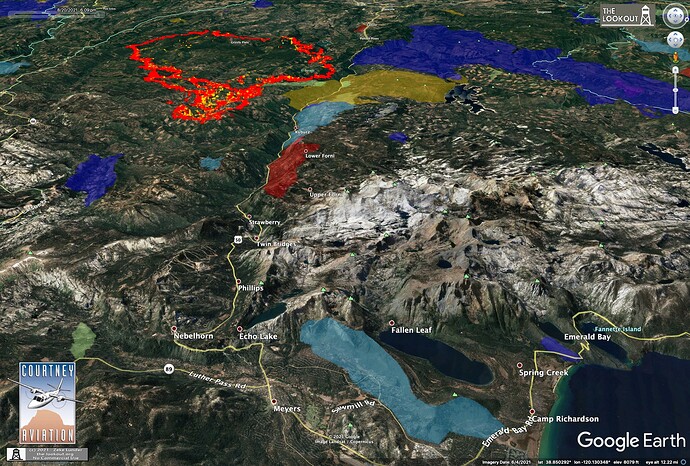
But is sure seems like the fuels and topography are all in place for it to make it to the Basin. I don’t think the granite high-country really comes into play if it is headed to Meyers. It pretty much has continuous fuel all the way into there, straight up Hwy 50. The fire has spread 18 miles in past 3 days, and many of those were without any real topographic influence. It’s only 16 air miles from the eastern tip of the fire to Meyers, and probably less after this evening’s run.
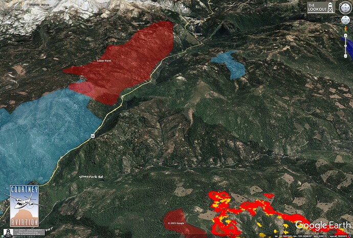
If it crosses the Silver Fork and can make a run out of there at the peak of the burning period, it’ll be in full-alignment and spot halfway to Strawberry.
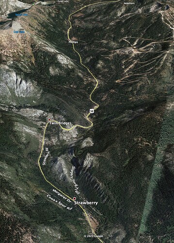
All the historic fires in the area have made big runs up the South Fork American River Canyon. There is a ton of fuel in fire-excluded forests all the way from Lover’s Leap to Echo Summit. There are some good gaps in there and big rocks, but no decent places to fight fire, and if it takes a couple days to make the run, we’ll get whipsawed by the canyon winds trying to save the hundreds of homes along the Hwy 50 Corridor with one road in and out of the whole area.
The lodgepole up on Echo Summit could burn like the sun.
Google Terrain View with today’s mid-afternoon IR.
Fire eye’s view of Silver Fork. Fire is established in bottom of this perspective.
And a RFW for peak of burning period tomorrow:
SATURDAY…
Sky/Weather…Mostly sunny. Hazy.
Max Temperature…76-82 lower elevations…except 65-75 higher elevations.
24 hr Trend…5 degrees cooler.
Min Humidity…23-29 percent.
24 hr Trend…7 percent up.
20-Foot Winds…
Valleys/Lwr Slopes…South winds 11 to 17 mph with local gusts up to 30 mph.
Ridges/Upr Slopes…Breezy. Southwest winds 15 to 27 mph with local gusts up to 35 mph.
Exactly All I’m saying is prepare for the worst and hope for the best. Especially this year… Don’t count on granite.
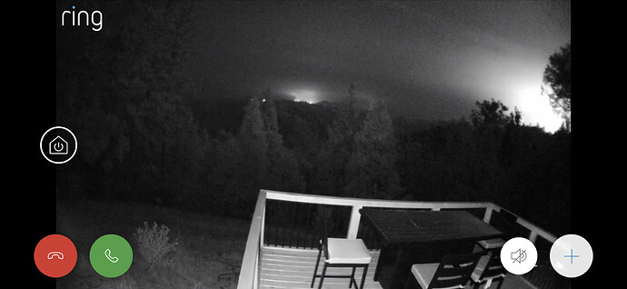
I’d appreciate any insight you all have on the SW corner near Slug Gulch. Our house is about 1/2 way up Slug Gulch (near the switchback) and we can see what looks like fire (hard to tell how far away) from our camera that faces North.
Also, we saw a fire truck cruise through the front of our house around 5:30 today when we were watching the Facebook live update. No idea if that’s a good or bad sign…
Blockquote
I’m not a meteorologist, at all, so I have no idea if conditions are going to be conducive to a big run.
Blockquote
Hey Zeke, I am and the winds are literally in perfect alignment. Already sustained 25g35 near the crest. The SW winds are already blowing just above and through the crowns. Can’t imagine the Silver Fork is more than a speed bump. Only saving grace is strong winds aloft may be occurring at night. A true 24 hour burn period ahead. Near perfect alignment and heavy fuels so stressed with such efficient spotting. No inversion to start the day tomorrow, she’ll be puffing all day. Real tough sledding ahead.
The Caltopo is always about 3 hours behind on the heat scans, due to proof reading the data. I have added the roads systems and burn history to help place the heat with physical locations on the ground. This is the fire heat signatures over the top of USFS topo maps.
It’s updated about 4-5 hour intervals. So , check back: zoom in and out and pan around…
There’s a slider tab on the left and right to open to full screen.
RAMMB satellites have the heat as kinda splotches(bright red is hot). It’s cooling off as the red is cooling down. It’s the evening humidity and temps should reduce activity a bit. Burning periods are getting shorter with each day, which something to hope for: (most recent early night scan and takes 3 minutes or longer to load)
https://rammb-slider.cira.colostate.edu/?sat=goes-17&sec=conus&x=7638.34716796875&y=3640.247314453125&z=6&angle=0&im=18&ts=1&st=0&et=0&speed=130&motion=loop&maps[borders]=white&lat=0&p[0]=fire_temperature&p[1]=band_02&p[2]=geocolor&opacity[0]=1&opacity[1]=0.5&opacity[2]=0.5&pause=0&slider=-1&hide_controls=0&mouse_draw=0&follow_feature=0&follow_hide=0&s=rammb-slider&draw_color=FFD700&draw_width=6
I would say a good thing in that they know your house is there. It may have been part of an active patrol area or even possibly looking ahead at WUI options such as prep or prep and defend.
Sorry, I was replying to a specific post so I assumed it would be clear from context - ridge is unnamed, or at least I’m not aware of a name; campground is Pipi.
Hard to say without knowing exact geographic orientation of your home in relation to the fire. I know there are engine strike teams in the area evaluating homes for potential structure defense if the fire does head that way. Very common well in advance of a fire front. It is a good thing, if your home has good defensible space and needs no work, crews well drive past after marking it and continue prepping homes. All precautionary. No word on the line that the fire is impacting structures anywhere on this fire as of this post. Pretty quiet night so far. Hopefully it stays that way.
I asked an FBAN friend if I was smoking crack to think it was possible the Caldor might make it to Meyers and he said ‘Yes, you are smoking crack’. Posting his reply here:
No. Not possible. However, I didn’t think the Dixie would hit 700K. That’s my ol’ stomping grounds and one of the factors people neglect to consider is the Delta. If you look at history, the nighttme recoveries. The day length and Delta influence should keep in between 88 and 50, which I can’t believe I’m saying. The one Crazy Ivan the Delta can bring is the westerlys. Evening winds can get a little gusty, especially in the Consumnes. The Consumnes is lined up with the Delta like no other river system other than maybe the Moke.
Getting through the Desolation or over Brockway is a tall order. The King hung up in the rock. I know, it’s not the King and it’s not the same time of year, but it’s much different up there.
My biggest fear now is the fall pattern that will most certainly set up soon. All of these fires will hammer some s*% if there’s easterly winds.
But this fire is farther south of the King fire. Doesn’t that mean it has a path to reach South Tahoe via the 50 that the King fire didn’t have?
Do not underestimate the Marine Influence, It can move the dry Valley airmass up and down any canyon in the Sacramento or San Joaquin Valleys. Look at the Rim fire, or the Creek fire. If the fog moves 20 miles, so does that dry air. The Marine Influence is a major driver of wildfire in California.
Yes I believe it does…The fuels from Silver Fork to Echo Summit are well overgrown and it would be possible to shoot the gap there, especially considering the spotting issues we’ve consistently seen this year. Desolation provides a big granite backstop north of 50, but to the south is another story. This fire provides a path that the King didn’t. Still kind of a long shot IMHO but must be considered possible.
Friends living in South Lake Tahoe said, smoke is really bad today and doesn’t feel these fires will be stopped. He’s retired FS and decided to evacuate home and head to Reno.
We are in quadrant 26 just past the switchback before blazing star. Our camera picked up some fire starting about 1:30 am. The camera orientation is facing north.
Power is off now, but we do have a generator that will last a few days.
We need to be to very careful here as many citizens are reading this page for updates and some folks here are predicting this fire burning to Tahoe. There is a lot of hysteria in the community and they don’t need anymore. If there is modeling and FBAN input that suggests this running to Tahoe, then give us a professional briefing. But for the speculators to write here that it can or may happen, doesn’t do the citizenry any good. Just my two cents
I’ll repeat my post from earlier when discussing the offshore wind event that thankfully did not come to fruition as bad as thought.
This is a very dangerous fire/situation. The winds will be blowing towards the N/NE. To my neighbors in the Southern/Western Tahoe basin, now is the time to prepare and think about what you need to take and gather it for quick loading. No one can tell you for certain whether it will arrive in the basin, but remember the Angora. Nobody up there expected its fire behavior either. You all live a area that can burn, if you haven’t already done so, make today your training for the year and plan the what ifs.
Once your done, sit back and read the commentary/info here and feel good you’ve done everything you can to prepare for this fire or the fire that might pop up in the future.


