They are not dangerous. In fact, they may save lives as nearby folks can see in live time what is occurring. Everyone that this matters to is well aware of his location.
What is dangerous is trying to shut down information. He provides a good service with disclaimers. I saw nothing dangerous in his broad cast just GOOD information.
Let’s get back to the fire and save the chit chat to private messages
Mod Note: Enough already of this debate on whether there are location errors with his broadcast. The platform he uses, which is not is first choice, does not allow the pin-point accuracy that Periscope did. Secondly, he makes note of that fact in most if not all of his broadcasts. Thirdly, he is a member of this forum, posts good information when he does and has been a solid member of the firefighting community very long before his photojournalism days. Before you begin attacking the individual, please recognize that sometimes technology not the individual is causing misinformation.
Now can we please get back to the actual business of this fire?
Hey guys,
I sure didn’t mean to ruffle feathers here. I am not completely happy with HAPPS and the location issue is one of the reasons. I have reached out to them and will express my issues with the app, especially regarding location reporting. I can certainly understand everyone’s frustration. I usually put the actual location in the title so ppl can have that as a clue. As for my reporting, I just talk about what I see, being as I am not an official source of information. What you get from me is raw video of what’s actually happening.
Take care……Tod
Looking at the GOES heat satellites looks like fire is pretty close to top of Bald Mountain. EDITED: Got some better intel it HAS reached top of Bald Mtn, but not any confirmation of spotting farther up the Canyon. That would put today’s spread at about 4 miles since last night at 8pm, and put the fire about 4 miles west of Strawberry.
Weather people, how much longer are we going to have these winds with us?
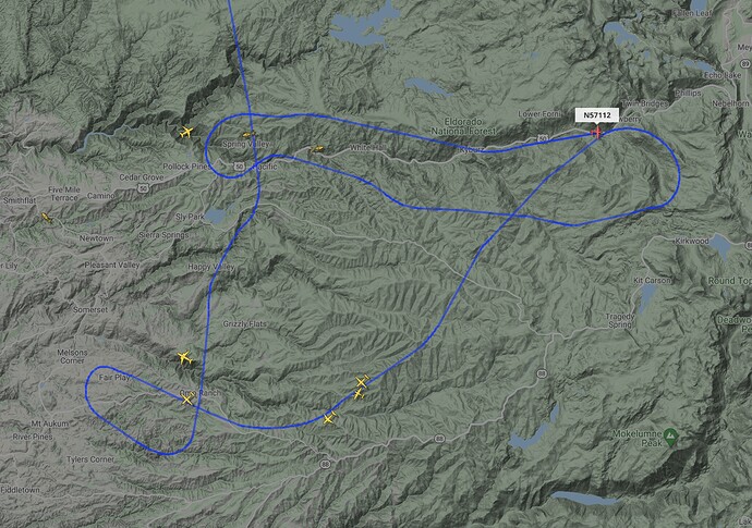
EDIT: 18:45, IR ship is over the fire, their flight path should do a pretty good job of showing the relative location of the eastward edge of the fire.
Haven’t looked closely today but by 8-9 pm the main winds should be done. Today was the key day to get through imo.
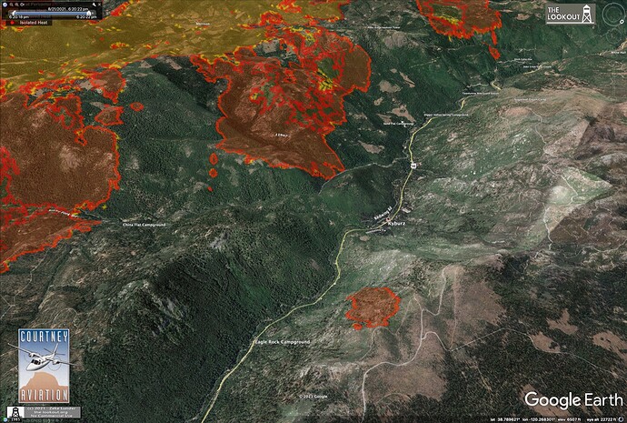
Did they catch the spot across 50
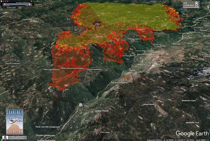
Nope, here is IR from 18:30. Show it as 60 acres.
Bunch of maps here:
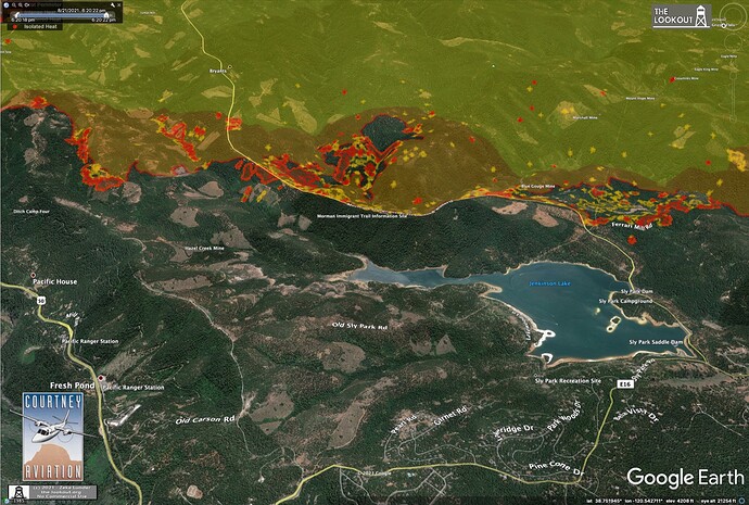
Caldor Fire – 8/21/2021 Evening Update – The Lookout
New heat detection on FIRMS & CalTopo using VIIRS. Spot one mile (.95) west of Cody Lake at 38.75732, -120.16086. Spot identified at 15:01. That is 4 miles from main fire front so I’m really hoping its a mistake and will disappear tomorrow. That would be an impressive spot but a big one to note, in the slideshow if it does in fact end up being valid.
I’m just wondering about the real possibility of this getting into Sierra at Tahoe Ski resort. And reeking havoc with all the chair lift infrastructure and lodges with little access and of course all the residential structures around it. But also continuing into twin bridges area to the south east and making runs in that back country. We’ll see if the great granite fuel break helps there’s a reason no fire history is recorded in them parts. Crossing fingers some of my favorite back country.
EDCfae…No problem, I just love instant information. Most of what we see is either hours after or days later. Its great to see what is happening as it happens. Most of us are dozens or hundreds of miles away from the fire and just want to stay abreast of fire news.
I think we are all looking at wind direction, fuel types, red flags, prior treatments, burn scars (and history) and natural barriers on a day to day to study this fire. Every day we go through the motions of the probability of spread, gauge from past days and do a few quick calculations. I’d like to think that the Tahoe Basin has had some lessons learned from fires like the Angora and have done some work within the basin to promote more of a fire safe community. Hopefully some triage is already starting to take place and folks who may have needed a little nudge are now getting the motivation they need to get things cleaned up a bit more. Every year these fires seem to get up and go a bot more in their burning periods. IF it get’s to the basin, hopefully they will be ready. Also, perhaps the team has a few ideas about possibly pulling off a burn op.
Looks like it landed in the 2004 Fred’s Fire scar. If memory serves there was a rowdy strike team of FBANs between that and the Power Fire.
South Lake Tahoe received evacuation warnings today. Family with vacation homes just on the Nevada side got calls and messages for evacuations recommendations.
I wonder if it has potential to hit South Lake and that’s becomes more of a higher probability as we monitor for days if they’ll pull some resources from other fires like Dixie nearby. Hard times with lack of resources.
If it even makes it in the area of echo summit I’d be blown away. But just doin 21 days on the Dixie it wouldn’t surprise me. Hopefully they can get some air resources into those sparse areas to make a good hold in some of those natural barriers and hope it doesn’t get a head of steam before it and steam roll over. Crossing fingers
It’s always going to have the potential it’s whether the alignment happens for it to be favorable.
Yes, I think few people ever do the math on what it takes to contain something with so much perimeter. Just measuring this thing with big straight lines, it is 60 miles around, and when you look at all the zigzags and islands this thing easily has 100 miles of perimeter, not-much of it being dozer friendly. And there is major WUI in both prevailing winds directions. It is an unmitigated disaster of a project.
The IR tonight shows spots around where they fired at Sly Park. It’s just a big messy fire with no easy prospects on just about any flank except Highway 50, and there, the spot at Kyburz might outflank us with downcanyon winds in the light-flashy fuels. And if we deal with the spot, that huge, south-facing shadeless section along the old Freds and Cleveland Burns is likely to take a lot of spots as we deal with fire in and out of all the side-drainages on the other side of the River.


