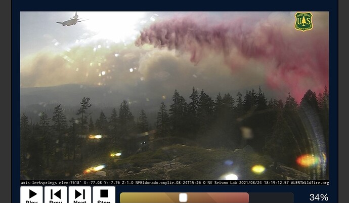
KCRA has the live update
Really unfortunate drift on the Leeks camera.
Here is the damage assessment map
https://gis.data.cnra.ca.gov/apps/366d1a3e25ce4a11a4c0846c3a337ce9/explore
It does not appear that they have assessed Slug Gulch yet, but this map will update as time goes on.
[quote=“Mjohnson, post:273, topic:19025, full:true”]
I’m having trouble finding a reliable map to see if my house is still there. If anyone has a good link, please let me know.
We are on slug gulch where there was a lot of activity last night and today. Some maps show the house may have been saved and some show it was engulfed in the fire.[/quote]
Hi TKg… check outage flight radar. hover over you home area and select a help or plane. you will see where they are doing most of their work…
good luck
Watched the briefing on the feed. It was well done! They are doing the best they can with current resources up to 2100 personal now and also priority fire in the nation for aircraft. Operations stated priorities currently are on the West or East in no particular order 1A and 1B which is in line with the diurnal wind shifts. We all know what is on each end. The big spread day was last Tuesday a week ago when the fire spread 40,000 acres with now daily sustained but not rapid growth. A lot of chiefs spoke and they answered questions from the public. Very positive and informative.
Comments: Many different agencies involved in this one depending on which way it goes. The ICS system may be the only way to overcome all these different agencies and imaginary boundaries involved in a successful fire fight. These imaginary boundaries include forests, fire agencies, potentially GACC’s, States, federal, private, water districts, … The complexity of this incident is beyond belief. This site has many former and current fire people with a wealth of knowledge and one of the few places I go for intel on fires. The quality of intel here is unmatched of any site on the internet. Please post what you can to help those boots on the ground doing the real work get intel. Take time and think it out and offer up advice and intel to make this ICS system for us all. Keep it coming!
Thank you all. I have summer home at 42 milestone, which has been in the family for 3 going on 4 generations. I know that you ALL are doing everything possible to save the memories along with our amazing playground. Myself and my family will be forever grateful, regardless the outcome. Please be safe. Life is more important than real estate.
Yes. It seems like good Rh recovery during the last few nights have helped a bit.
firebeeman1, the Intel will continue to flow well. Those that are new on the site need to pause and watch unless they have vetted and substantiated intelligence, not unverified information. As far as working with the ICS you have to ask what problem you need to solve, this site will give you access to a network of SMEs and folks that can offer advice. There are lots of discussions going on right now on some of the issues you and others are experiencing.
Indeed they have helped a lot. For weeks prior to the fire we had lows in the 70s and RHs in the 20s. One night lower Pollock had a low of 79, the hottest overnight low in the North State, it was the same as Red Bluffs. I’m 100 percent positive that inversion layer helped. Preheat this stupid fire.
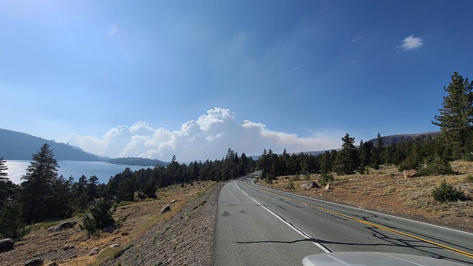
I took this picture from Hwy 88 at Caples Lake about 1630 yesterday. The picture really doesn’t due the actual scene justice.
Anyone have any first hand info on the accuracy of MODIS and VIIRS spot detections? First paper I found indicated ±1km for MODIS and 375m for VIIRS but that may depend on pixel size. NASA indicates errors are often encounter during repositioning of the equipment in space and during solar storms. Seems like this would be an important disclaimer (maybe I just didn’t see it) on the various maps being distributed using these data. People are losing their minds over the fire detections in Sly Park Hills but based on similar errors observed during the backburn along the MET south of Jenkinson I assume these are just detection error unless they felt the need to burn some yards west if the Sly Park road.
VIIRS has been pretty darn accurate for us this season as far as location goes. The Pixel count has not been as accurate for estimating size. Some fires would show just a pixle or two, but the size of the fire would range between 1/4ac & 5 acres. The location, in my opinion, is the most important part of its accuracy. Being able to locate an unreported fire, regardless of size, is what counts.
Afternoon folks, lets get back to the information relating to the incident please. Feel free to start a new thread in General Discussion regarding MODIS/VIIRS
Those charts are from South Ops Central Sierra predictive service area. The northern part of that zone is still south of the fire area, which is in area NC07. But in each you must consider the charts are showing averaged data from multiple weather stations in the specific area. Here is a link to NOPS charts from which you can select PSA NC07 or a specific station. Whitecloud and Bald Mountain are the two closest stations that have charts on that link, but are on the western side of the incident, and thus should not be seen as representative of the entire incident footprint…
North Ops PSA’s
To get the most accurate readings for the fire area, go the NOPS Predictive Services site, Fuels/Fire Danger tab. Then choose FS year round sites. Open, then click Bald Mt. This is less than 10 miles north of most of the fire and at the same elevation. VERY representative of the fire area.
Evacuation warnings just went out for Part of the Lake Tahoe Basin
It’s been that way for a few days now. Per the briefing, what will activate a warning in the basin proper is if the area up to Echo Summit becomes mandatory.
If you scroll in on the map, you will see that the evacuation warning area is at the crest.


