For sure just wondering if anyone heard radio traffic of such
Airtac let operations know they have no relief available and will have to return to base for crew swap etc. Still not enough visibility for fixed wing
Looks like they are picking out of Sly Park Resv.
It took crews four hours to even get to the heel of the last night. Blow down on logging and service roads hampered efforts. The vegetation is very dense in that area and it’s very steep. With the lack of safety zones, effective escape routes, and in terrain not seen in daylight, no size up, no one with eyes on the whole fire, you can all pretty much do the math. This was all heard on the scanner last night. The box must be getting pretty big.
Yep. Down canyon…drainage winds and those are being helped by the clockwise rotation around the High in the Great Basin. Check the IR satellite. Clouds are moving from the SE.
Any news on what is being deployed today?
The Sacramento Regional IMT was in briefing this morning, there will be no IAP posted until the team has taken the fire. I doubt the ENF is concerned about post ing an IAP that is probably mostly tbd. Let the team get on the incident and get its feet under it first.
Steep, loaded with fuel, lots of dead and down in the middle fork. Large potential, hopefully they can get aircraft if there soon. Hiked that a bunch a couple years ago. Be safe there. No time for an IAP right now.
Anyone have the IAP or any of the mapping?
https://linksharing.samsungcloud.com/xc0MznyAgczW
Here’s a IR map
I imagine when the IAP is up it will be here.
https://ftp.wildfire.gov/public/incident_specific_data/calif_n/!2021_FEDERAL_Incidents/CA-ENF-024030_Caldor/
Thank you…
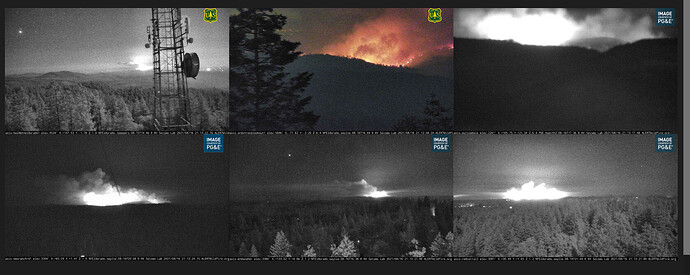
Shortly after sundown when all the aircraft left, things got a lot more active on the cameras. The images from six of the more active ones is below.
I was just looking at these. From the Danaher camera in Camino you can really see it well.
I heard on the radio that they were going to order a evacuation warning for Grizzly. Can anyone confirm?
Sounded like the local gov Chief inserted himself with a few volunteer engines (not assigned to incident) at leoni meadows and had told Ops there was a spot fire in there. Ops wanted to confirm that was accurate before making a determination. That was about 45 min ago. Nothing more about a spot fire at leoni or from local gov units.

