Another angle.
6 Likes
Intel’s flight from around noon.
5 Likes
I believe this rapid spread, at the current wind and slope driven direction, is heading for Lake Issabella. That could be many evacuations. But perhaps in a couple days or through the night? Smoke drift is already over the lake.
3 Likes
White caps on the lake and column.
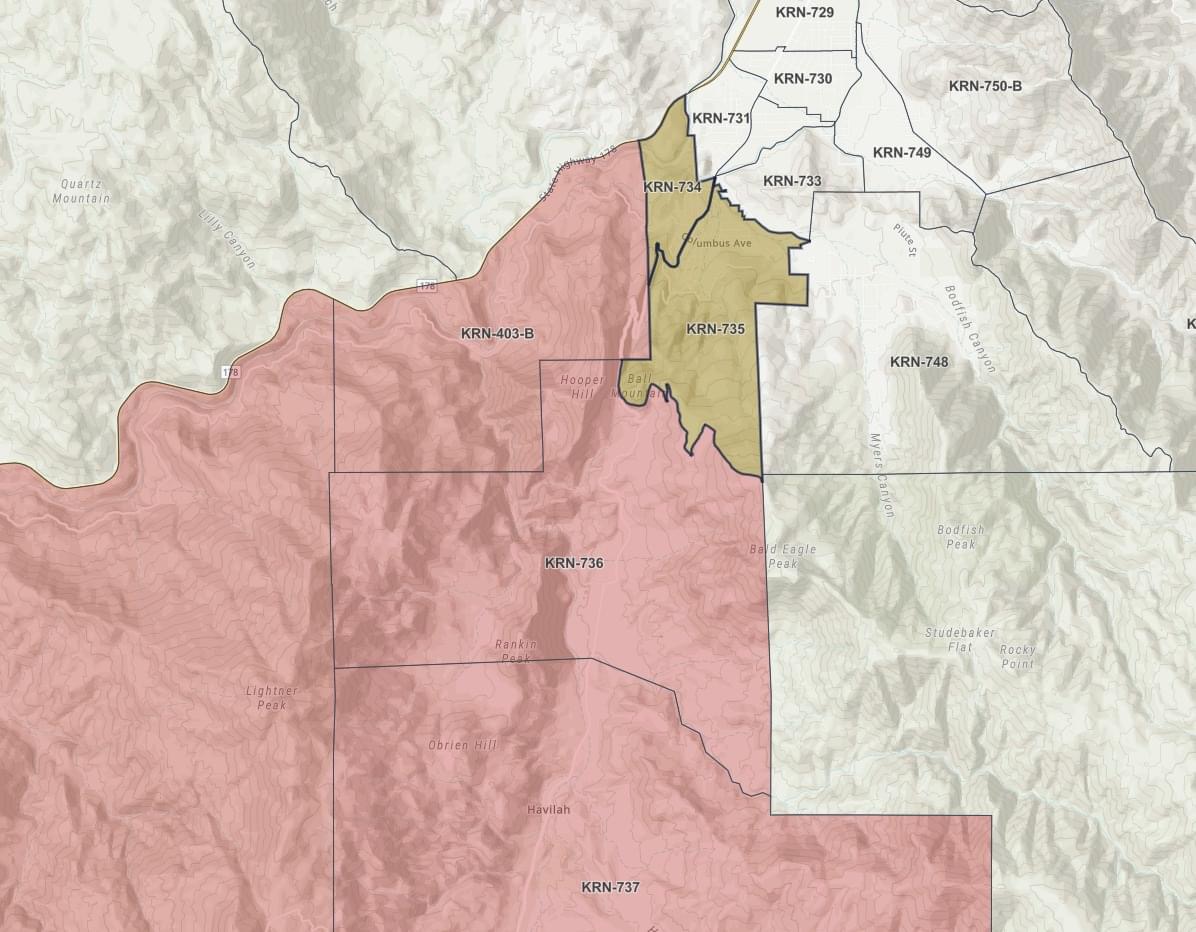
posing a real and immediate threat to Bodfish Canyon Road. Delayed but likely threat to Town of Lake Isabella.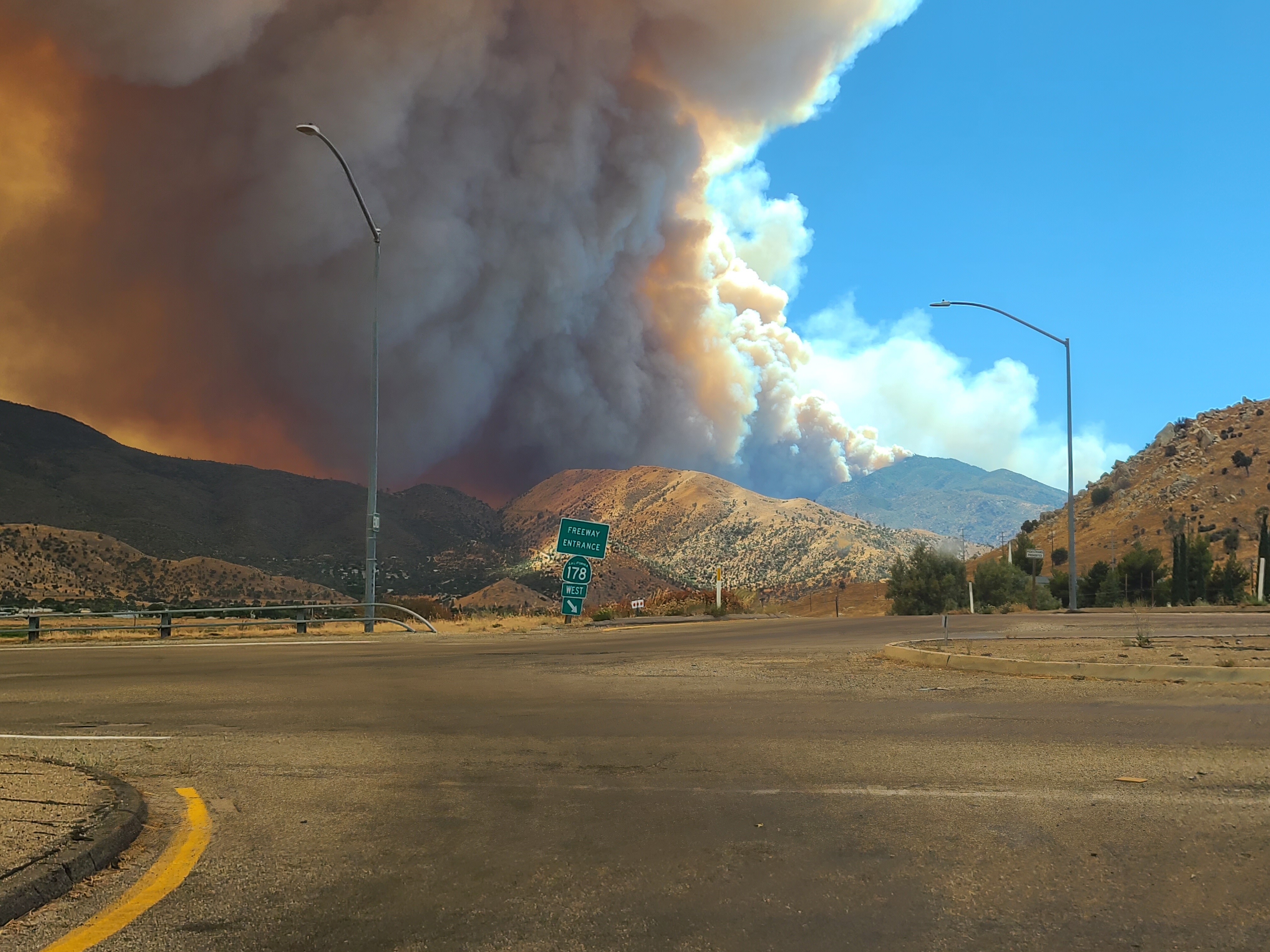
13 Likes
RAWS station Breckenridge (could be peak/ridge top winds)
Well, it’s at 7500" anyhow…
Winds direction= towards north 320-280 degrees
Speed = 4-20mph
Brush fuel stick= 4% (critical)
Air temp at 7500’= 80
Humidity= 24
Ripe for fire growth.
5 Likes
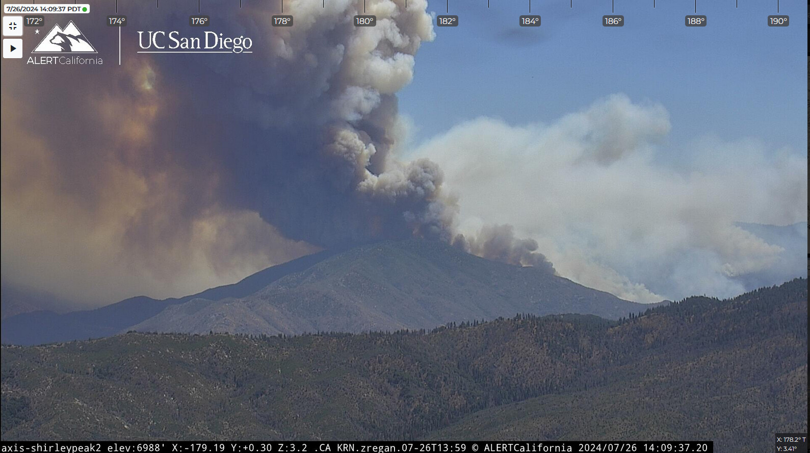
Studying the Rocky Point, Mebane, and Breckenridge cameras, it seems like this fire is following a well established historical pattern - though I’ve usually seen it on the north-side of 178, not usually on one that starts on the south-side like this one did. This site has had many discussions in the past because firefighters unfamiliar with the wind pattern in the Kern River Canyon/Lake Isabella area wonder why they are being chased downhill from the top of Shirley, through Wofford Heights, all the way to the Lake’s edge.
We would call it the toilet bowl effect. The desert heats up faster and hotter than the Central Valley. Physics make the desert want to equalize the thermal low so it draws the air up the Kern Canyon, around the sides of Cook Peak, (and Wofford Heights) and out the south lake area and through Walker pass to the desert. Areas to the north and east of the current head should have their head on a swivel because if it follows that pattern , it is going to surprise some that don’t know history.
That being said, I’ll say that in the dozen years as a Chief in that battalion and the 18 in the department I haven’t seen one do exactly what this one is doing… This is unusual in my limited book. Under the Red Flag and hot and dry conditions we are experiencing I would expect the unexpected, pay close attention to your SA, and for God’s sake, keep your head on a swivel and know where you are and how to safely get out of that location if it is needed. It’s already gone from 900 to 9,000 in short order.
7 Likes
USFS is asking CHP to shut down Caliente bodfish road from the 178 to the 58.
Evac order and warning just expanded.
2 Likes
So y’all don’t think I blew him and his question off, I replied to him in a private message.
4 Likes
I haven’t hear/read since this morning, it was 3000 acres so
over double or likely 8000 acres by 16:00? Any updates?
I see it’s side slope spreading still up slope from base of Breckenridge below the cam site. Cam site could be impacted.
1 Like
This afternoons flight had it as 7,951 acres. Based on the fire activity observed I’d say it has passed that
3 Likes
Living in Weldon about 18 miles from the fires edge. I have mapped fires going back to the 40’s. This reminds me of the fire siege of 1942, fires kept popping up every few days and many able bodied men were off on fighting the war.
Currently fuel moisture is down but not as dry as September when these canyon fires take off. Our temperatures have exceeded 100° for 25 straight days. Overnight recovery has been non existent for 2-weeks.
No inversion last night so the fire cooked straight down the east side of Breckenridge once it hit the ridge around 1:30 last night.
Too many residents here who pay no attention until the fire is on top of them. Havilah sadly had way too much tall grass waiting for a spark.
In the KRV proper, I do clearance on my and neighboring property even though I am now a senior citizen.
Question about strike teams was related to getting people to get out of the darn way and let firefighters do their job.
Thanks for the intel.
5 Likes
IMT is not using CA OES FIRS data. So the growth has not been being recorded accurately. FIRS mapped at ~951 to ~1,681 to ~3,000 to ~9,000 to ~13,000. Growth has been steady but blew up today. Winds pushing it downhill through some really dry chaparral built up since the 1970 Havilah fire. Lots of WUI along Breckenridge Road.
Winds have shifted this afternoon. Fire was heading due east but now appears to be moving NE.
Forty-four years of local insight and I am still not prepared for this one.
1 Like
It’s crossed bodfish caliente Rd heading up to the piutes very quick
2 Likes
Oh crap! That could drop it into Bodfish from the top down. Not gonna be a good week at Camp 9!
4 Likes
12,796 acres
5 Likes
VNC Charlie S/T responding to this incident as of 1700.
3 Likes
I spoke with JohnHavilah who is a regular contributor on this site. He evacuated his home right as the fire came downslope from Breckenridge. It crossed Caliente-Bodfish road in front of him and and wound up with fire on both sides of the road. He made it out okay, a little worn out and his hair might be shorter on one side. From his vantage it went across the road is established in the Piutes on the east side of Havilah. That is almost the same location where you could hear on Kern-2 that multiple engines and a KCSO deputy had a close call with fire on both sides. Unknown on structure loss in the location.
14 Likes
Caliente Bodfish Road has been closed at Kern Canyon Road, per Kern County Fire. Evacuees from the Bodfish and Breckenridge area will only be able to travel North on Caliente Bodfish Road to the shelter in Lake Isabella.
2 Likes

That was on the Golf Fire.
2 Likes