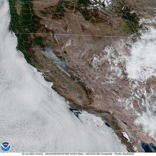
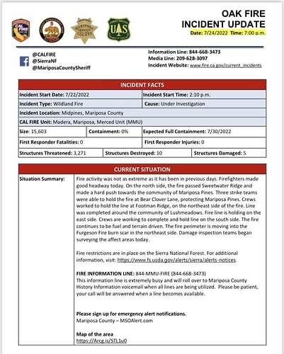
Airattack reports now @ 11,800 ac
Forecast:
Spot Forecast for OAK…CALFIRE
National Weather Service Hanford CA
242 PM PDT Sat Jul 23 2022
Forecast is based on forecast start time of 1900 PDT on July 23.
If conditions become unrepresentative…contact the National Weather
Service.
.DISCUSSION…
Hot and dry conditions will persist during the period with
afternoon breezy conditions. Return of afternoon and evening
thunderstorms across the Sierra starting on Thursday and
continuing through next weekend.
.REST OF TONIGHT…
Sky/weather…Mostly cloudy then becoming partly cloudy.
Areas of smoke.
Min temperature…63-68.
Max humidity…20-25 percent.
Eye level winds…North winds up to 4 mph in the evening shifting
to the east up to 3 mph overnight.
Surrounding ridge…North winds up to 5 mph.
Mixing height…lowering to around 100 ft AGL after 2100 PDT.
Transport winds…Northeast around 5 mph.
.SUNDAY…
Sky/weather…Mostly sunny. Areas of smoke.
Max temperature…91-96.
Min humidity…10-15 percent.
Eye level winds…South winds up to 5 mph in the morning shifting
to the southwest in the afternoon.
Surrounding ridge…Southwest winds up to 5 mph.
Mixing height…Rising to around 6100 ft AGL after 0800 PDT.
Transport winds…Southwest around 4 mph.
.SUNDAY NIGHT…
Sky/weather…Mostly cloudy. Areas of smoke.
Min temperature…64-69.
Max humidity…25-30 percent.
Eye level winds…North winds up to 5 mph in the evening shifting
to the northeast overnight.
Surrounding ridge…Northeast winds up to 5 mph.
Mixing height…lowering to around 100 ft AGL after 2100 PDT.
Transport winds…Northeast around 5 mph.
$$
Forecaster…BARLOW
Requested by…Troy Velin
Type of request…WILDFIRE
.TAG 2215573.1/HNX
.DELDT 07/23/22
.FormatterVersion 1.0.26
OES 2801A being dispatched from Monterey County
#OakFire off Hwy 140 and Carstens Rd, near Midpines, in Mariposa County is 11,900 acres. In Unified Command: CAL FIRE Madera-Mariposa-Merced and Sierra National Forest.
Link to the daily products- Maps, IAPs, etc
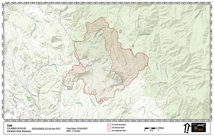
The 3 to 5am heat map update on Caltopo:
(Usual 2-3 hour delay for signatures. Also smoke will give some false heat signatures with this size of fire -FYI )
https://caltopo.com/map.html#ll=37.54145,-119.86432&z=12&b=t&o=f16a%2Cr&n=1,0.25&a=mba%2Cfire%2Cmodis_mp
Last night:
Also Signal Peak lookout said the fire laid down once it hit the Ferguson Scar into creeping. Lacking a good fuel bed of regrowth…maybe that line is controlled, so to speak.
Per this AM’s 209:
CALFIRE IMT 5
14,281 Acres (+2,381) @ 0% Containment
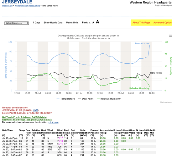
Observed Fire Behavior overnight: The fire remained active overnight primarily in Branch I and III. where the fire continued to back toward Jerseydale.
5 Structures Damaged, 10 Destroyed, 2,693 Threatened
Evacuation Order:
-North of Highway 49, east of Cole Road
-Lush Meadows north of Highway 49
-Bootjack, north of Highway 49, east of Cole Road
-North of Morning Star, east of Lakeview Road and Plumbers Creek Road, south of Highway 140
-Jerseydale
Evacuation Warnings:
-North and east of Indian Peak Road and All Red Road
-South of Morning Star and Highway 49
-West of the East Fork of Chowchilla River
-North and west of Highway 140 near Mariposa
-East of East Whitlock Road
-North of Highway 49 near Mariposa
-East and south of Oliver Creek Road, west of Chowchilla Mountain Road
-Ponderosa Basin
*Previous reporting period indicated 6,052 civilians under evacuation order. More accurate census data was obtained and the number of civilians currently under evacuation order is estimated to be 3,027. The number of civilians currently under evacuation warning is estimated to be 1,909.
Critical Resource Needs: 12hrs 20 strike teams Type 3 engines; 15 strike teams Type 1 crews; 25 dozers; 20 water tenders; 15 DIVS; 4 OPBD.
2,093 Personnel Assigned, Projected Containment Date 7/30/2022
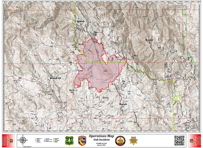
Re-sized Ops & NIROPS IR Maps for today:
Nice update.
New start Ahwanee area, loosing some aircraft:
https://www.alertwildfire.org/region/sierra/?camera=Axis-Deadwood2
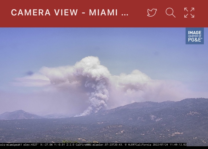
Nice column on Deadwood2 cam
I have family at 42999 Wither Ranch Road(end of Bessie Jacob’s) confirming fire on crooks mountain.
It’s down near Grub Gulch. Looks line they are getting a handle on it.
2030ish hours, FIRIS 16520 acres
IR flight underway

